Walk #134: Burnham Deepdale to Wells-Next-The-Sea
 |
 |
|
General Data
| Date Walked | 21/01/2001 |
| County | Norfolk |
| Start Location | Burnham Deepdale |
| End Location | Wells-next-the-Sea |
| Start time | 10.19 |
| End time | 14.38 |
| Distance | 9.5 miles |
| Description | This was a pleasant walk following the North Norfolk Coast Path along beaches and a little road walking. |
| Pack | I did not carry a pack today. |
| Condition | I am feeling fine, which is very good considering I did the last few miles at a deliberately fast pace as I wanted to finish as soon as possible. My feet are fine and my legs are okay with no signs of strains or pain. I was not carrying any pack (apart from a light one containing Sam's trainers and a little water), so that could explain the lack of problems. |
| Weather | The weather started off cloudy but dry, but after about an hour it started to drizzle with rain. This continued for the rest of the walk, with the rain sometimes being stronger and at other times weaker. There was no sign of sun at all during the day, and a fairly fierce wind meant that the rain was doubly less welcome. |
| OS map | Landranger number 132 (North West Norfolk, King's Lynn & Fakenham) |
 |
 |
|
Map of the walk
Maps courtesy of Google Maps. Route for indicative purposes only, and may have been plotted after the walk. Please let me have comments on what you think of this new format. For a detailed table of timings for this walk, please see the table file.
Notes
This was a pleasant walk that was spoiled by intermittent rain and drizzle for the majority of it's duration. This was an undoubted shame, as the scenery was very nice in many places and would have been best seen in decent weather. Nonetheless I found today very enjoyable despite the weather.
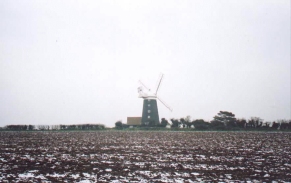
The windmill between Burnham Norton and Burnham Overy Staithe was a very nice example of this sort of building, with a nice location being matched by some pretty associated buildings. A recent map showed the windmill as being disused and the sails were not turning despite the blustery wind so it could be that the sails can no longer turn, but even so it is lovely to see such a nice example of this sort of building with its sails intact. It is apparently now let out as accomodation for holidaymakers, and it must make an unusual weekend's accomodation!
Apparently Burnham Over Staithe is the place where it is thought hat Lord Nelson learnt to sail - he was born a couple of miles to the south at Burnham Thorpe. The sea defences which we walked along on the eastern side of the River Burn after Burnham Overy Stithe were in the process of being strengthened, and this made for a very firm footpath which could be followed as far as the sand dunes. Apparently this work is as part of a one million pound flood defence scheme, where the clay ambankments at Burnham Overy Staithe are being raised and widened and defences at Wells-Next-The-Sea were being improved.
There is something about walking beside the sea and along beaches that is very plesant and relaxing, even on cold and damp days such as today. In my opinion it is equally as pleasant as mountain walking, and certainly less exhausting. Today was a classic example of this; waking along the beach towards Holkham Gap with a broad expanse of sand leading down to the barely-visible beach in the distance, treading on countless thousands of broken seashells at the tideline. It was an absolutely lovely walking location, despite the weather.
Unfortunately Sam found the going from Burnham Overy quite hard, and this meant that progress was quite slow over the dunes and along the beach on the middle section of the walk. When we reached Holkham Gap Sam was having more trouble, so when we got to the car park there I suggested that she walk down to the A149 and find shelter from the rain around that area. I then put on a fast pace so that she would not have too long a period to wait, and averaged about four miles an hour over the section of the walk to the south of the forest.
The tide was out whilst we were walking along the beach towards Wells-next-the-Sea, and the beach appeared to stretch away for miles to the sea. I twas one of the widest beaches that I can remember seeing, and at stages you could se pinpricks in the distance that turned out to be walkers or even horseriders.
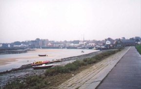
Wells-next-the-Sea was one of the greatest ports in Eastern England in Tudor Times, but since then access to the sea has reduced. It remains the only port on the North Norfolk Coast to be commercially viable (for instance Thornham saw it's last commercial ship in the 1930's). It is very much a tourist town, with a permanent population of 3,000 being joined by over 10,000 holidaymakers during the summer holidays. It is amazing to think about this increase in numbers as it did not seem that big a town - when it is busy it must be bursting at the seams! This makes me fairly glad that I visited it in January which is totally out of season. Look here for more information on Wells-next-the-Sea.
Over the last two days I have walked about twenty miles, which is unfortunately not the sort of distances that I need to be doing in order to complete all of the walking that I wish to be doing this year. Therefore I am going to have to start increasing the distances I walk each day, which will fortuitously coincide with the days getting longer. I really need to be aiming at doing regular sixteen or seventeen mile walks with all my kit by the end of March.
Directions
This walk starts from Burnham Deepdale church beside the A149 road. Turn left down the A149 and follow it eastwards for about two kilometres until you meet a road leading off to the left at TF823438. Turn left down this road and follow it into the little village of Burnham Norton.
When the road ends take a footpath that leads eastwards beside a drainage ditch, towards a windmill in the distance. This soon becomes a floodbank which crosses the River Burn via a Sluice. On the other side of the sluice continue straight across a field towards the windmill. At the top eastern edge of the field near the windmill turn left and follow a path (which avoids you walking on a road) that skirts the edge of the field before joining the A149.
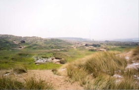
Descend downhill on a pavement beside the A149 into Burnham Overy Staithe. The road starts to bend around to the right and head eastwards, and shortly after it does so take a road to the left opposite a pub which leads to the harbour. Take the North Norfolk Coast Path as it heads along a flood bank on the eastern side of the River Burn estuary, and follow it as it heads out northwards to meet a large expanse of sand dunes. At an obvious junction turn left to gain access to the beach, or turn right as we did and stagger around in the sand dunes for a long time.
Head east across the dunes until you some to the edge of a wooded area. When you meet these turn left and head north over the dunes until you reach the beach at Holkham Bay. Turn right down the beach and follow it for a couple of kilometres until you reach Holkham Gap, an obvious gap in the trees. Head south towards the car park at Holkham Gap, at the northern edge of which is a footpath leading off to the left on the southern edge of yet another wooded area.
The path skirts the southern edge of the woodland in a roughly easterly direction for about two and a half kilometres, until the lifeboat station at Wells-Next-The-Sea is reached. Here you can turn right and follow either the road or a path on top of the floodbank south for one and a half kilometres to the harbour at Wells-Next-The-Sea.
Distances
| From | To | Distance (m) | Ascent (ft) | Descent (ft) |
|---|---|---|---|---|
| Burnham Deepdale | Burnham Overy Staithe | 2.7 | 75 | 92 |
| Burnham Overy Staithe | Holkham Gap | 3.8 | 49 | 46 |
| Holkham Gap | Wells-Next-The-Sea | 3.0 | 49 | 52 |
This makes a total distance of 9.5 miles, with 173 feet of ascent and 190 feet of descent.
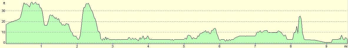
For more information on profiles, ascents and descents, see this page
Transport
We used a taxi firm to get from Wells-Next-The-Sea, where we spent the night, to the start of the walk at Burnham Deepdale. The taxi driver was an exceedingly nice Yorkshireman, and he took us on a little detour to see Burnham Market, which seemed to be a very attractive little village and one that I will have to visit again sometime for a closer look.
Disclaimer
Please note that I take no responsibility for anything that may happen when following these directions. If you intend to follow this route, then please use the relevant maps and check the route out before you go out. As always when walking, use common sense and you should be fine.
If you find any information on any of these routes that is inaccurate, or you wish to add anything, then please email me.
All images on this site are © of the author. Any reproduction, retransmissions, or republication of all or part of any document found on this site is expressly prohibited, unless the author has explicitly granted its prior written consent to so reproduce, retransmit, or republish the material. All other rights reserved.
Although this site includes links providing convenient direct access to other Internet sites, I do not endorse, approve, certify or make warranties or representations as to the accuracy of the information on these sites.
And finally, enjoy your walking!
This walk was mentioned in the following routes:
| A walk around East Anglia |
Nearby walks
| # | Title | Walk length (miles) |
|---|---|---|
| 133 | Hunstanton to Burnham Deepdale | 10.3 |
| 160 | Wells-Next-The-Sea to Cley-next-the-Sea | 11.1 |
| 254 | Hunstanton to Wells-next-the-Sea | 21.7 |
|
|

|