Walk #663: Great Shelford to Milton
 |
 |
|
General Data
| Date Walked | 01/05/2005 |
| County | Cambridgeshire |
| Start Location | Great Shelford |
| End Location | Milton |
| Start time | 09.58 |
| End time | 13.38 |
| Distance | 11.0 miles |
| Description | This was a pleasant short walk, following the River Cam northwards through the centre of Cambridge. |
| Pack | Today I carried my 70-litre Craghoppers rucksack, which contained Westwind tent, sleeping bag, inflatable roll mat and various electrical items. All of this weighed 13.7 kg (30.2lb). |
| Condition | My feet are slightly hot after this walk, a sign that my boots are still not broken in fully. Aside from this I am fine, and only the weekend closure of the railway line from Ely to Cambridge prevented me from extending it on to Waterbeach. |
| Weather | It was a nice day today, with generally good weather. It was quite warm, and although it spitted with rain towards the end I was not bothered as I soon dried off in the heat. |
| OS map | Landranger number 154 (Cambridge & Newmarket, Saffron Walden) |
 |
 |
|
 |
 |
|
Map of the walk
Maps courtesy of Google Maps. Route for indicative purposes only, and may have been plotted after the walk. Please let me have comments on what you think of this new format. For a detailed table of timings for this walk, please see the table file.
 |
 |
|
Notes
Next week I am heading off to take part on the TGO Challenge walk between Kyle of Lochalsh and Montrose, and I am well aware that I have not done quite as much practice as I should have done, particularly with a heavy pack on my back. I also did not feel much like driving anywhere, and so I decide it had to be a local walk. Whilst talking to Sencan, a friend and colleague of mine yesterday, I mentioned that I wanted to do a walk, and she mentioned that she had to go to Milton (a village north of Cambridge) to visit a computer store. The conversation continued and we then agreed that, if the weather was nice, we should use the opportunity to walk up to Milton today.
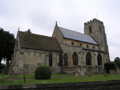
The day dawned sunny and bright, and when Sencan phoned me up still wanting to go on the walk I readily agreed. I packed up my rucksack with a reasonable loading of kit (although not as heavy as I would be carrying on the TGO), and I started off down the road towards Sencan's house, which is situated about a mile away. As I neared the entrance to a large garden centre I could see her approaching down the road, wearing her trademark Tilley Hat, and we soon started walking up the road. This was hardly a salubrious start to the walk, as it is a road that both of us know exceedingly well, and there is not much of interest to note. We soon found ourselves at a large road junction, and we then joined a winding, minor road that led us through Grantchester, heading past the gates fiercely guarding the privacy of the village's most famous residents, before reaching the church. We then diverted of to the right towards The Orchard.
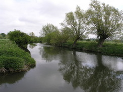
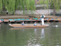
The Orchard is a tea room with a difference; not only does it serve superb food, but it has an adjacent museum dedicated to the writings of Rupert Brooke, the wartime poet who died on the way to the mud-drenched misery of French trenches. He lived in Grantchester, continuing a long association with great English poets; a short distance away is Byron's pool, where the poet is believed to have swum whilst studying at Cambridge. Thankfully road walking was now done with, and we walked along a path that led across Grantchester Meadows - the place where the early Pink Floyd spent time grooving in a cave with a Pict'. My first memories of this meadow were from the water, whilst taking part in the 1998 punt race along the river from Cambridge to Grantchester and back. I availed Sencan to stories of this as we walked, and remembered fondly that it took much longer for the return journey due to the amount of alcohol that we had drunk!
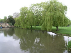
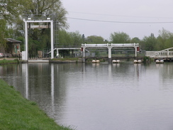
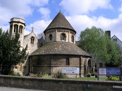
We soon found ourselves passing Scudamore's boatyard, and passing the mill pond, before walking into the centre of the city. There followed a whole series of beautiful buildings, and far too many to detail here. Instead I will just name a few; King's college, the gateway leading into Trinity College, and the round church, the latter one of only four medieval round churches left in Britain. Shortly after this we reached the end of the majority of the road walking for the day, and we settled on a nice riverside footpath that took us past Jesus Green. It was tempting to nip into the Fort St George pub for a quick drink, but time was against us, and instead we walked on. Near the Pike and eel pub we used a footbridge to cross over to the western bank of the river, and we then followed this path as it heads northwards.
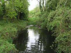
I had walked along here many times before as I used to live in Fen Ditton, on the other side of the river, and it was a joy to be walking again along this path. I looked longingly across the river at a riverside pub that I used to frequent whilst working at Acorn, and we continued chatting as we walked on, heading under the A14 and reaching Bait's Bite Lock. We knew that the shop Sencan wished to visit shut at 14.00, and as there was not much time we decide to take a short cut through Milton Country Park. This was a bit of a risk as I had never been through the park before (despite living in the village for six months in 1997/1998!), but we found a glorious route through the trees, passing the lakes, and even a light shower could not dampen our mood. We passed the visitor centre in the park, and then we emerged into a totally different world of an industrial estate; the contrast was stunning. The shop Sencan wished to visit was inside the park, and we reached it just under half an hour before it was due to shut. It had been a wonderful walk, and the shortness of the trip was more than made up for by the superb company that I had.
Directions
This walk starts off at the post office on Great Shelford, which is situated by the A1301road in the village. From the post office head north along the road; it soon crosses a rail bridge and continues on northwestwards for abut a mile and a half, before ending at a T-junction with the A1309 Trumpington High Street. At the junction turn right, and then cross the road before taking the first road off to the left, Maris Lane. This soon ends at another junction; there turn left and follow Grantchester Road as it heads in a rough westerly direction. It crosses a tributary of the River Cam at Brasley Bridge, and soon crosses the main river near an old mill.
The road winds around through Grantchester, and shortly after passing the church turn right down a path that heads past a pub. At the end of this, take an obvious footpath that heads northwards. This path is also a cycle path, and it heads northwards for about a mile and a half before ending at a road. Continue on along this road, and then turn left along Eltisley Avenue. When this ends at a junction after a short distance, turn left and follow the road northwards until it ends at the A603 Newnham road. Continue along the A603 northwards for a few yards, but then take a footpath that leads off across the common to the right. This crosses Fen Causeway on an angled crossing, and the path then follows the western bank of the Cam northwards until the mill pond is reached.
Cross the bridge in front of the mill pond, with Scudamore's punt yard on the right, and then follow Mill Lane as it heads up, starting at the Anchor pub and ending at Trumpington Street. Turn left and follow Trumpington Street as it heads northwards, soon becoming King's Parade as it passes King's College, and then Trinity Street as it passes that college. When the road ends at a crossroads by the Round Church, turn left along Bridge Street and then turn right up Thompson's Lane before the bridge over the Cam is reached. When Thompson's Lane turns sharply to the right, continue straight on along a footpath that follows the southern bank of the River Cam onwards. The Cam draws a large arc, passing Jesus Green and the adjacent river lock, before reaching Victoria bridge.
Continue on along the path along the southern bank of the river past one footbridge; the path passes under the Elizabeth Way road, and afterwards the riverside path becomes a road, passing the industrial museum before ending at the southwestern edge of Stourbridge Common. Join the riverside path and follow it until another footbridge is reached; cross this, and once at the road on the other side turn right and walk past a pub, where the northern bank of the river can be reached. Continue on along this path as it skirts the river bank; it passes under a railway bridge before eventually reaching the main A14 bridge. Continue on along the path past Baits Bite Lock and continue on for a couple of hundred yards until a track leads off to the left. Turn left and follow this track as it heads northwestwards, becoming Fen Road as it cross the railway line. Once over the railway line some houses are passed on the left; turn left through a gap and go through a gate to enter Milton nature reserve. It is hard to describe a route through the reserve, but various paths meander past the lakes towards the visitor centre; one there head out through the car park towards the Crane Industrial Estate; the walk ends at a roundabout at the end of the road, directly opposite a Tesco's supermarket.
Distances
| From | To | Distance (m) | Ascent (ft) | Descent (ft) |
|---|---|---|---|---|
| Great Shelford | King's College, Cambridge | 5.4 | 82 | 118 |
| King's College, Cambridge | Milton | 5.6 | 43 | 39 |
This makes a total distance of 11.0 miles, with 125 feet of ascent and 157 feet of descent.
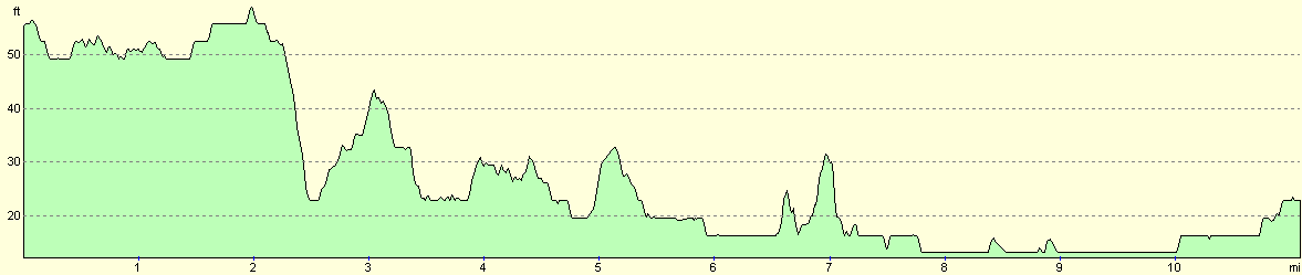
For more information on profiles, ascents and descents, see this page
Transport
Stagecoach Cambridge runs regular (half-hourly on Saturday) bus services from Milton into the centre of Cambridge, where the Stagecoach C7 bus can be taken south to Great Shelford via the railway station and Addenbrookes Hospital.
Disclaimer
Please note that I take no responsibility for anything that may happen when following these directions. If you intend to follow this route, then please use the relevant maps and check the route out before you go out. As always when walking, use common sense and you should be fine.
If you find any information on any of these routes that is inaccurate, or you wish to add anything, then please email me.
All images on this site are © of the author. Any reproduction, retransmissions, or republication of all or part of any document found on this site is expressly prohibited, unless the author has explicitly granted its prior written consent to so reproduce, retransmit, or republish the material. All other rights reserved.
Although this site includes links providing convenient direct access to other Internet sites, I do not endorse, approve, certify or make warranties or representations as to the accuracy of the information on these sites.
And finally, enjoy your walking!
Nearby walks
| # | Title | Walk length (miles) |
|---|---|---|
| 2 | Waterbeach to Newmarket Road, Cambridge | 5.4 |
| 5 | A short walk around Waterbeach to Car Dyke | 3.0 |
| 6 | Waterbeach to Newmarket Road, Cambridge | 5.4 |
|
|

|