Walk #32: Standedge to Mankinholes
 |
 |
|
General Data
| Date Walked | 09/08/1999 |
| County | West Yorkshire |
| Start Location | Standedge |
| End Location | Mankinholes |
| Start time | 08.20 |
| End time | 16.00 |
| Distance | 14.2 miles |
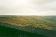
| Description | This was a pleasant walk northwards towards Mankinholes and Hebden Bridge; some pretty moorland is crossed on the way. |
| Pack | Today I carried full camping gear. |
| Condition | My legs are fine; when I got to Stoodley Pike Monument I shrugged off my pack and climbed up to get the wonderful views from the top. My feet are also okay; the two blisters from earlier in the week have almost gone, and a hotspot that has developed on my right foot has been covered with the Sccholl variant of blister pad. I did having trouble with my back, however - in places it is red, raw, and quite painful. |
| Weather | The previous night had horrendous weather, loads of rain and wind. I was quit snug though. Once the walk started, there were high winds and drizzle initially but the drizzle became more intermittent as they day went on. The wind did not die down though, and I did not see a peak of sun all day. |
| OS map | Outdoor Leisure number 1 (The Peak District - Dark Peak Area) and Outdoor Leisure number 21 (South Pennines) |
Map of the walk
Maps courtesy of Google Maps. Route for indicative purposes only, and may have been plotted after the walk. Please let me have comments on what you think of this new format. For a detailed table of timings for this walk, please see the table file.
Notes
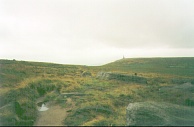
This was a fairly easy day's walking, my legs not giving much trouble and I made very good time, actually arving above Mankinholes far to arly for the opening of the YHA at 5.00 so I went up to Stoodley Pike and generally waited around for a while. This gave me the opportunity to climb up to the top of this structure to admire some fairly spectacular views, whilst I listened to the results of the Liberal Democrat leadership election.
Today was a fairly flat walk, with many short and gentle climbs and descents. It was certainly nowhere near as strenuous as the last couple of days, and this allowed me to relax a little and enjoy the walk.
My back is giving my cause for concern, though I will try another day and see what happens. At times yesterdy it was agony. Tomorrow I am going all out for Ponden, although if I am making good time I may extend to Lothersdale.
Unfortunately I have had some big problems - my entire lower back is red raw. When I was unloading my pack in the drying room here at Mankinholes Youth Hostel I think I discovered the reason - when I reassembled my pack after washing it a few weeks ago, I put the framing in in such a way that the lower half was pressing straight into the small of my back. I have now corrected this and bought some Savlon to rub into my back. The next morning it is still tender but good enough to carry on. I have also tried the pack out and it feels generally better, with the lower half not pressing into the small of my back.
Directions
I am not going to bother giving any directions for any of the stages of the Pennine Way; there are many route descriptions produced that will better anything that I could produce. The main guides I used were the OS National Trail Guides, which come complete with strip maps of the route. Click on one of the links below to go to the Amazon page for each guide.
|
| 
|
| |
| |
Distances
| From | To | Distance (m) | Ascent (ft) | Descent (ft) |
|---|---|---|---|---|
| Standedge | M62 | 5.0 | 755 | 627 |
| M62 | Light Hazzles Reservoir | 4.0 | 512 | 522 |
| Light Hazzles Reservoir | Makinholes youth hostel | 5.2 | 407 | 925 |
This makes a total distance of 14.2 miles, with 1674 feet of ascent and 2074 feet of descent.
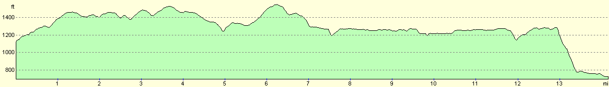
For more information on profiles, ascents and descents, see this page
Disclaimer
Please note that I take no responsibility for anything that may happen when following these directions. If you intend to follow this route, then please use the relevant maps and check the route out before you go out. As always when walking, use common sense and you should be fine.
If you find any information on any of these routes that is inaccurate, or you wish to add anything, then please email me.
All images on this site are © of the author. Any reproduction, retransmissions, or republication of all or part of any document found on this site is expressly prohibited, unless the author has explicitly granted its prior written consent to so reproduce, retransmit, or republish the material. All other rights reserved.
Although this site includes links providing convenient direct access to other Internet sites, I do not endorse, approve, certify or make warranties or representations as to the accuracy of the information on these sites.
And finally, enjoy your walking!
This walk was mentioned in the following routes:
| My sectional Land's End to John O'Groats walk |
| My Pennine Way Walk, 07th to 26th August 1999 |
Nearby walks
| # | Title | Walk length (miles) |
|---|---|---|
| 31 | Crowden to Standedge | 11.7 |
| 33 | Mankinholes to Ponden | 12.7 |
| 144 | A circular walk from Crowden to Black Hill | 8.9 |
|
|

|