Walk #144: A circular walk from Crowden to Black Hill
 |
 |
|
General Data
| Date Walked | 28/07/2001 |
| County | Derbyshire, South Yorkshire, Greater Manchester |
| Start Location | Crowden |
| End Location | Crowden |
| Start time | 08.00 |
| End time | 13.41 |
| Distance | 8.9 miles |
| Description | This is a circular walk taking in the highest points in the counties of South Yorkshire and Greater Manchester. |
| Pack | Today I carried my Craghoppers 70-litre rucksack with no tent. |
| Condition | Reasonable. My legs and ankles are fine, but my right shoulder aches a little. The worst problem is that I am suffering from a little heatstroke which is making me feel slightly woozy. Despite applying suntan lotion three times, I am slightly sunburnt on my legs. My forearms and my neck and face. |
| Weather | The weather today was very hot and sunny, with temperatures around the thirty degree mark later on. Whilst I was walking there was no sign of any cloud, and the temperature and sun was very strong. There was also absolutely no wind, which made the heat stifling. |
| OS map | Outdoor Leisure number 1 (The Peak District - Dark Peak Area) |
 |
 |
|
Map of the walk
Maps courtesy of Google Maps. Route for indicative purposes only, and may have been plotted after the walk. Please let me have comments on what you think of this new format. For a detailed table of timings for this walk, please see the table file.
Notes
The main aim of this walk was to walk to the highest point of the county of Greater Manchester, at Black Chew Head. I had walked within a few hundred yards of this on the second day of my Pennine Way walk, but at the time I was not interested in county tops and therefore I ignored it. Since I did not want to go up the Pennine Way to the point and return the same way, I decided it would be good training for my next walk in Scotland if I were to walk up from Crowden to Black Hill by a back route, and then return to Crowden via Black Chew Head and the Pennine Way.
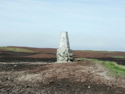
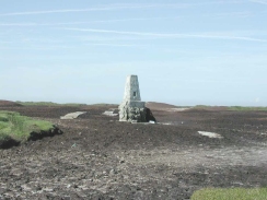
The initial part of the walk up to the top of Black Hill was quite nice, and I managed to cover the distance in a respectable time. I loitered around at the top of Black Hill (the Trig point of which is at a place called Soldier's Lump) for a while, enjoying the sun. Since I had last been up here when I was doing the Pennine Way the path to and around the Trig point had been paved, and there were paving slabs heading north from the Trig point towards the end of the plateau. The difference in the top now it has a causey laid is quite spectacular; no longer does it look like some form of Martian wilderness.
The journey back down from Black Hill was punctuated many times by my talking to people; firstly when my girlfriend phoned me for five minutes just after I had come off the summit, and later on I met a couple of gentlemen who I chatted to for about twenty minutes. We discussed how ill-prepared some of the people who were walking that day seemed to be - one group of three people had members who were wearing sandals and only a little rucksack between the three of them, which was obviously not enough to carry enough water for three people on such a hot day. They asked me what I was doing and I mentioned my attempts to walk from Land's End to John O'Groats and my County Tops walk and they seemed amazed - it was a nice (if not slightly ego-inflating) feeling to see people in awe of what I am doing.
On the descent I deviated off the Pennine Way to find Black Chew Head, the highest point in Greater Manchester. As there is no trig point on the top (or indeed any noticeable top) it was fairly hard to find, so I used my GPS to get the rough position and stood on the highest piece of ground between the groughs in the area. This was not necessarily the most scientific or accurate of approaches to find the top, but with no Trig point and the variations in height caused by the clints and groughs it had to do.
I am very glad that I set off early, as it meant that I avoided the hottest parts of the day, or at least did not have to climb hills during that period. It was also nice to get on the hills whilst they were still quiet, although I did meet a group of three people on the descent from White Low that had set off on their walk (essentially the reverse of mine) at a quarter to six in the morning!
I had been expecting the ascent up to Black Hill via White Law to be the hardest part of the walk, but in reality the descent via the Pennine Way was much harder. Although the route via White Law was less well defined, route finding was still relatively easy and the ground underfoot firm and soft. The descent by the Pennine Way was very tough, mainly due to the sun, and the path, although well defined was quite narrow and stoney.
The early finish meant that I could relax in the shower at the campsite for a while without having to hurry. Since it was still very early when I emerged I drove down the road and into the town of Stalybridge to have a look at the Huddersfield Narrow Canal, which had been reopened through the centre of the town a few months earlier. The centre of the town, complete with canal and canalside Tesco superstore was very nice, but walk away from the canal and the area was shabby and unfortunately very run-down.
After calling into the Tesco's to buy a four pack of beer and a book I drove back to the campsite and read the book for a few hours before heading to the nearest pub in Tintwistle (three miles from the casmpsite) at six for a meal. After that I went and read the book until dark and tiredness consumed me.
Directions
This walk starts off in the little village of Crowden, just off the A628(T) west of Woodhead bridge. Crowden has a youth hostel and a campsite, and this walk starts from the campsite. Turn left out of the campsite and continue past the farm. A track starts to head uphill to the right, and follow this track until a ladder stile is reached on the right. Cross this stile and follow a track uphill until it starts to bend sharply around to the left in a hairpin bend. Do not go around the bend but take a footpath that leads uphill, aiming for just left of the obvious quarry workings.
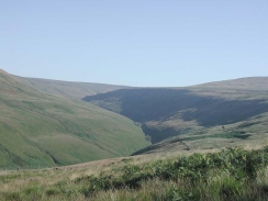
After a steep climb uphill a stile leads over a fence and onto some access land. The path then continues in a roughly northerly direction to the west of the disused quarry. The path then heads in a north-northeasterly direction up the side of the valley along an indistinct track. As the track starts to skirt leftwards along the side of the valley of Crowden Little Brook, head away from the track and slowly climb the valley side to reach Hey Moss.
From Hey Moss the track becomes more distinct on the ground and is visible climbing up the hill to the top of Westend Moss. In the distance the Holme Moss television mast can be seen on the skyline, and the next section of the walk follows the path over Westend Moss towards the mast.
After Westend Moss comes White Low. At this point the path veers away from the television mast and starts to head northwards, descending across Tooleyshaw Moor before climbing up a little ridge onto Tooleyshaw Moss in a northwesterly direction until a fence is reached. Get over the fence using one of the stiles and then head along the path to the trig pillar at the top of Black Hill.
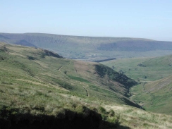
From Black Hill the path follows the route of the Pennine Way in a south-westerly direction. The initial section of the walk is caused with stone slabs and leads down over Dun Hill and over a fence onto the access land. The path then descends to meet Meadowgrain Clough which it follows all the way dwon to Crowden. The path skirts the western side of the Clough as it starts to deepen, before rising up high on the side of the valley with the brook deep below you. The path crosses several fords as it descends, some of which are dry in dry weather.
Since the main aim of this walk was to walk to the highest point of the county of Greater Manchester at Black Chew Head at SE056020, when I reached a dry ford at SE060021 I turned to the right and followed the streambed uphill. I only managed to find Black Chew Head by using my GPS, as the highest point is hard to find due to all the channels on the top.
From Black Chew Head head in a southwesterly direction across Laddow Moss until you meet the footpath that leads from Chew Reservoir to Laddow Rocks. Turn left down this footpath and follow it to the Pennine Way at the top of Laddow Rocks.
Follow the Pennine Way as it starts to descend to the floor of the valley, passing the picturesque Oakenclough Brook in the process. The path from here on is very easy to find although a little rough underfoot until it ends in a T-junction with a minot road. Turn left down this road and head downhill across Crowden Brook back to the campsite.
Distances
| From | To | Distance (m) | Ascent (ft) | Descent (ft) |
|---|---|---|---|---|
| Crowden | Black Hill | 3.9 | 1306 | 115 |
| Black Hill | Black Chew Head | 2.3 | 322 | 449 |
| Black Chew Head | Crowden | 2.7 | 102 | 1161 |
This makes a total distance of 8.9 miles, with 1730 feet of ascent and 1725 feet of descent.
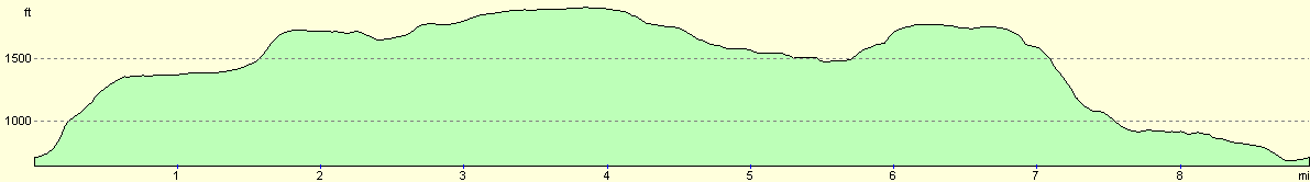
For more information on profiles, ascents and descents, see this page
Accommodation
I stayed at the Camping and Caravanning Club campsite in Crowden, Telephone 01457 866057. This is quite a nice campsite but passable facilities. There is also a Youth Hostel available in Crowden.
Disclaimer
Please note that I take no responsibility for anything that may happen when following these directions. If you intend to follow this route, then please use the relevant maps and check the route out before you go out. As always when walking, use common sense and you should be fine.
If you find any information on any of these routes that is inaccurate, or you wish to add anything, then please email me.
All images on this site are © of the author. Any reproduction, retransmissions, or republication of all or part of any document found on this site is expressly prohibited, unless the author has explicitly granted its prior written consent to so reproduce, retransmit, or republish the material. All other rights reserved.
Although this site includes links providing convenient direct access to other Internet sites, I do not endorse, approve, certify or make warranties or representations as to the accuracy of the information on these sites.
And finally, enjoy your walking!
Nearby walks
| # | Title | Walk length (miles) |
|---|---|---|
| 30 | Edale to Crowden | 16.5 |
| 31 | Crowden to Standedge | 11.7 |
| 32 | Standedge to Mankinholes | 14.2 |
|
|

|