Walk #145: A circular walk to Margery Hill from Derwent Resevoir
 |
 |
|
General Data
| Date Walked | 29/07/2001 |
| County | Derbyshire, South Yorkshire |
| Start Location | Fairholmes car park, Derwent Reservoir |
| End Location | Fairholmes car park, Derwent Reservoir |
| Start time | 08.15 |
| End time | 12.48 |
| Distance | 9.9 miles |
| Description | A hard but rewarding walk along the eastern sides of Derwent and Howden Reservoirs before ascending to the Trig point on Margery Hill, the highest point in the county of South Yorkshire. |
| Pack | Full Pennine-Way spec kit. |
| Condition | Okay. I fell much better than yesterday, although I was fairly fatigued at the end of this walk. My legs,back and shoulders are fine, but the underside of my feet ache. |
| Weather | It was very hot today, but a stiff breeze and thin, low broken cloud helped me to keep relatively cool, particularly on the tops ehere the wind was quite fierce. |
| OS map | Outdoor Leisure number 1 (The Peak District - Dark Peak Area) |
 |
Map of the walk
Maps courtesy of Google Maps. Route for indicative purposes only, and may have been plotted after the walk. Please let me have comments on what you think of this new format. For a detailed table of timings for this walk, please see the table file.
Notes
The main aim of this walk was to walk to the Trig point on Margery Hill, which is the highest point in the county of West Yorkshire. Since this is at a fairly remote piece of moorland I decided to park at the nearest available parking at Fairholmes car park and do a circular walk to the Trig point. The car park also has a visitor centre, which is open at weekends all year round and daily between Easter and the end of October.
The first part of this walk involved walking for a couple of miles along the side of Derwent Reservoir to Howden dam, and then along Howden Reservoir as far as Howden Clough. This initial part of the walk was easy going as the path alongside the reservoirs is a cycle track, and I therefore made good speed along this stretch.
The dams in this valley are very impressive, particularly the Derwent Reservoir dam which looks lovely when you stand beneath it and look up towards it's twin stone towers. They are in the process of making these dams stronger, and they have reopened a quarry nearby to provide the stone for the work. Howden dam was built in 1901 and Derwent dam in 1916, and a village called Birchinlee was built to house the workers on these two dams. The larger reservoir of Ladybower immediately to the south of Fairholmes car park was finished in 1943 and took two years to fill. At the time it was built it was the largest reservoir in Britain.
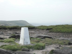
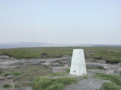
From Howden Clough the climb onto the moors started. I found this a reasonably strenuous walk, but I managed it with no trouble. The Trig point on the top of Margery Hill was strangely elusive when you were near it. It was easy to make out the lump that was the hill from the track along Howden Edge, but the Trig point was not visible until I had ascended the little hill. The views from the Trig point were lovely, however, with good views over Sheffield to the southeast and Kinder and the Dark Peak to the southwest. On hills to the north is a windfarm with thirteen wind turbines sitting on it which are very prominent from many places in the local area. They must generate much electricity, as the wind on top of Margery Hill was very strong and it kept on trying to blow me over during the walk south from the Trig point.
I was planning to use a track that is visible on the 1:25,000 OS map to get myself down from Howden Edge to Howden Reservoir. When I reached Row Top, where the track starts to descend westwards to the reservoir, I met a man walking up the hill who told me that the track was blocked by electric fences and gave me an alternative route to follow. This route was not marked on the map and hardly marked on the ground, but after a few minutes I found a rough path heading in the correct direction which eventually led me back to a lower level. A little way down from Row Top I came across the electric fences, which fortunately had a gap through which I could walk. There was a sign hanging on one of the fences stating that they were there to protect an ecologically delicate area of moorland.
The gap in the fences led to a rough track which headed towards the reservoirs for a short distance before it met a track that went through some gates and disappeared down the hillside into the valley below, meeting the cycle track by the reservoir just to the south of Howden Dam. It was then simply a case of trudging a couple of miles back to my car at Fairholmes car park; and a trudge it was as I found that I was quite fatigued.
This is an area of the Peak District that I have not walked much in before, and I will definitely have to explore it some more. At some time I will have to link this walk up with my Land's End to John o'Groats walk, and it looks as if the simplest way by which this can be done would be to walk from Edale over Kinder and to the Derwent Reservoir. Fortunately this is very much like I walk that I had been planning to do already, the two could be easily combined. Another possible walk would be to go from Langsett Youth Hostel south-westwards to Margery Hill. From Langsett it would be quite easy to get to Sheffield or Penistone, from both of which are links to other walks that I have planned.
Directions
This walk starts at the Fairholmes car park , which is situated at the very northern tip of Ladybower Reservoir. Head out of the car park along the path that passes northwards past the visitors centre until it meets a road. Turn right along this road and pass over the bridge that crosses a stream.
Once over the bridge the Derwent Reservoir dam becomes visible to the left, behind an area of green grass. Leave the road and head across the area of grass towards the eastern side of the dam, where some steps lead up the side of the valley to a road at the top of the dam.
Turn left along this road and follow it as it threads its way along the eastern side of the reservoir. After about two and a half kilometres Howden dam is reached. Continue on for another kilometre along the eastern bank of Howden reservoir until you reach Howden Clough.
Before the bridge carries you over Howden Clough take a footpath that heads northwestwards through the woodland on the eastern side of the clough. When the end of the woodland is reached the path crosses over to the northern side of the clough and passes a very small reservoir. The path then rises to the east for a short distance before turning to head northwards across Upper Hey.
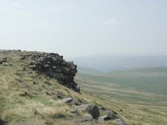
The path continues indistinctly across the ground northwards for about half a kilometre before it turns to head northeastwards and ascends slightly to skirt the bottom edge of Howden Edge. It then heads northwards to Cranberry Clough. I then turned right here and climbed up to the top of Wilfrey Edge over some very rough ground with no track; this was strenuous but fairly easy. When I reached the path at the top I turned left along it for a short distance until Margery Hill became visible; I then turned down a track towards it and the Trig point.
Initially I retraced my steps southwards from the Trig point along Wilfrey Edge. However instead of descending down the edge I continued along it for a couple of kilometres southwards to Row Top. Here the path meets a track that heads downhill to the west; I was advised to head down a indistinct track that leads off from here to the southwest. Once you get near to the edge of Row Top the path should become more visible on Howden Moor below. Descend down to the moor and then turn right to head southwestwards, paralleling the northern side of Abbey Brook.
The track is met again by a stream at SK 178 925, and can be followed down Hey bank through some woodland. The track ends at the cycle path just to the south of Derwent Reservoir, which can be followed south back to the car park.
Distances
| From | To | Distance (m) | Ascent (ft) | Descent (ft) |
|---|---|---|---|---|
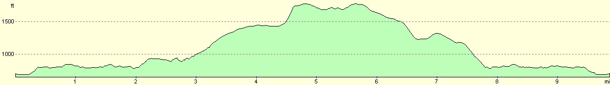
| Fairholmes Car park | Margery Hill | 4.8 | 1522 | 449 |
| Margery Hill | Fairholmes car park | 5.1 | 535 | 1608 |
This makes a total distance of 9.9 miles, with 2057 feet of ascent and 2057 feet of descent.
For more information on profiles, ascents and descents, see this page
Disclaimer
Please note that I take no responsibility for anything that may happen when following these directions. If you intend to follow this route, then please use the relevant maps and check the route out before you go out. As always when walking, use common sense and you should be fine.
If you find any information on any of these routes that is inaccurate, or you wish to add anything, then please email me.
All images on this site are © of the author. Any reproduction, retransmissions, or republication of all or part of any document found on this site is expressly prohibited, unless the author has explicitly granted its prior written consent to so reproduce, retransmit, or republish the material. All other rights reserved.
Although this site includes links providing convenient direct access to other Internet sites, I do not endorse, approve, certify or make warranties or representations as to the accuracy of the information on these sites.
And finally, enjoy your walking!
Nearby walks
| # | Title | Walk length (miles) |
|---|---|---|
| 13 | Edale and Kinder Scout | 11.0 |
| 19 | Castleton circular via Lose Hill and Mam Tor | 7.7 |
| 23 | The Limestone Way from Pomeroy to Castleton | 14.0 |
|
|

|