Walk #710: South Downs Way: Wether Down to Cocking
 |
 |
|
General Data
| Date Walked | 29/01/2006 |
| County | Hampshire, West Sussex |
| Start Location | Wether Down |
| End Location | Cocking |
| Start time | 08.37 |
| End time | 15.54 |
| Distance | 18.2 miles |
| Description | This was a superb walk following the South Downs Way as it heads eastwards across the border between Hampshire and West Sussex. |
| Pack | Today I carried my 70-litre Craghoppers containing a light load of spare clothes, waterproofs, a couple of books and food. |
| Condition | My right knee gave me a few brief periods of discomfort today, but aside from that I feel fine. I am quite tired at the end of the walk, but that is mainly down to lack of sleep than the walk that I have done. |
| Weather | The weather today was bright and sunny, allowing some superb views for most of the day. The wind was exceptionally chilly, however, and this proved to be annoying on occasion. All in all it was a god day for walking, the views more than making up for the discomfort from the cold. |
| OS map | Landranger number 185 (Winchester & Basingstoke, Andover & Romsey) and Landranger number 196 (The Solent & The Isle of Wight, Southampton & Portsmouth) |
 |
 |
|
 |
 |
|
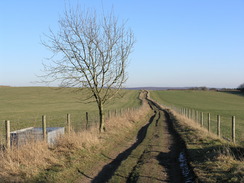
Map of the walk
Maps courtesy of Google Maps. Route for indicative purposes only, and may have been plotted after the walk. Please let me have comments on what you think of this new format. For a detailed table of timings for this walk, please see the table file.
 |
 |
|
 |
Notes
I awoke this morning in a good mood after a long and much-needed sleep, a result of the early start and long walk of yesterday. I could have done with more sleep, but the other two men staying at the hostel had an early start, and unfortunately their cars were parked right by my room. Rudely awoken by the sound of the engines I got up and read for a while, waiting for the early breakfast I had arranged with the warden for 07.30. This soon came, and I was greeted with a Continental breakfast. I was quite hungry as I had not eaten anything last evening, so I tucked in to some cereal and toast, chatting to the warden as I ate. She turned out to be a fascinating character, and all my good intentions for an early start went out of the window as we chatted. Eventually I realised that I had to get a move on, so I said my apologies and went back to my room to get ready.
The wind had been fiercely cold the day before, and as I did not want to get another chill I decided to wear my coat as an extra layer. This was not my preferred choice as I was concerned about getting too hot on the ascents, but the experience of yesterday showed that it would be prudent to wear it. It did not take me long to get ready, and after saying goodbye to the warden I went outside, to be instantly struck by a very cold wind that blew around the building. I started to wish that I had packed my balaclava for the trip, and instead I pulled the hood of my coat up to protect myself from the worst of the wind.
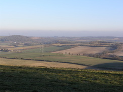
The clustered buildings around HMS Mercury were deserted and forlorn, and I wondered what uses the buildings and site would eventually be put to. It made the conversion of some of the buildings into the hostel seem a very good idea, and I found myself hoping that other good uses could be found for the other buildings. I was still exposed to the wind as I headed around the eastern side of the buildings and approached Hyden Cross, where I got the first good views of the day over towards East Meon. There followed a long and gradual climb uphill along a track, where I was fortunately protected from the wind as some cyclists made their way uphill past me.
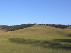
A long stretch of road with some good views to the west followed, before the way headed off into a car park on the flank of Butser Hill. I was tempted to nip up to the trig pillar at the top of the hill by the large radio mast, but I decided to press on as the path descended down a lovely grassy slope towards the A3(T). An underpass took me under the road, and I then reached the large car park for the Queen Elizabeth Country Park, and when I reached the main visitor centre I nipped into the toilets. When I emerged the shop was about to open, so I waited around for a few minutes, and then went inside. There was nothing much that I wanted to buy, so instead I walked across the courtyard to the café and went inside.
I quickly ordered a large mug of tea and a bacon and egg sandwich, and read the guidebook as I waited ten minutes for the sandwich to arrive. I soon scoffed it down, and I ignored the temptation of buying some chocolate when leaving the building. The country park is a series of interconnecting paths but I found the route very easy to find as it headed towards the base of Gravelhill Bottom. This is a little valley, and the path headed uphill along this, and the route was fairly busy for the early hour of the day with cyclists and horse riders. I found myself being quite impressed with the country park - it was a very well organised and planned area in attractive surroundings, and as I walked I found myself wishing there was a similar hilly area near to me in Cambridge.
As the path climbed I could see three cyclists coming down a small track on the hillside to my left, roar across the track and then over a little bunny jump on the right and up the other side of the valley. They were repeatedly doing this, and as I passed I saw that they were some cyclists who had been in the café. They were well padded up, and I stopped to watch them do some jumps. The first two men completed successfully, but the third one hit the little cess at he left-hand side of the track at the wrong angle, lost his balance and skidded sideways across the track. There were cries of 'wipeout!' from the hillside to the right, but when they saw that the man had not gone up they ran down to see. I held back, and when I could see he was relatively okay I continued on up the hill.
The path became quieter when I reached the top of the hill, and I was disappointed to see that the views were blocked out by the trees that surrounded the path. A descent followed to another car park at Fagg's Farm, and there followed a long road walk with occasional good views north over Buriton. The road ended and the sound of a train passing through the tunnel under the hill reverberated through the air as I stood admiring the views. The track soon became a road and it allowed me to have an exceedingly easy stroll as it headed eastwards towards Sunwood Farm. This used to be the western end of the South Downs Way before it was extended to Winchester in 1989, and I could not help but feel that Winchester is a far more suitable place to end a long-distance trail.
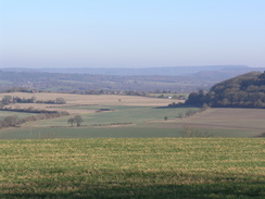
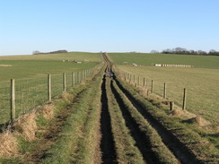
A steep climb up a track followed, and it continued on, occasionally climbing and falling before dropping down to cross the B2146 road. My feet were starting to feel slightly sore by this time, and the next stretch through woodland did not improve matters as it followed a rough track uphill to eventually meet another road. On the other side of this there was a car park, and there were plenty of people about as I followed the path along the edge of Harting Down, where there were some nice views over the village of South Harting. The path descended down to a little cross, and instead of heading straight up to the summit of Beacon Hill it started climbing up past Bramsholt Bottom. After the superb views of the last mile this was a slight disappointment as there were no views, and when the path turned to head north near Telegraph House the views did not improve.
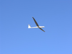
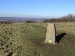
The South Downs Way does not visit the top of Telegraph Hill, and so I decided to divert off to visit the summit. An easy but steep path led me uphill towards the trig pillar and topograph at the summit, and just when I reached them a white glider came overhead, contrasting beautifully against the blue sky. I was tempted to stop for a rest at the pillar, but just as I was starting to unbuckle my rucksack some people came up, and I decided to head on. A steep stretch of path led me down to the South Downs Way once again, and a muddy track led me up to the next summit, Pen Hill. There were some more good views to be had from here, but these started to vanish as I headed down to Mount Sinai .
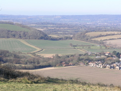
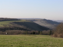
The next couple of miles proved to be fairly boring as it wound around southeastwards, before eventually climbing uphill onto Philliswood Down along a track that had no views. The path passed a little memorial to a Greman who died in 1940, before passing the Devil's Jumps tumuli and curving to head eastwards past Monckton House through dark and gloomy trees. It was a relief when the track emerged from the trees onto Didling Hill, descending slightly before climbing up towards Linch Ball. Here I diverted away from the good track to go into the field to visit the trig pillar, which was easy to find in the middle of the field. When I reached it I was greeted with some good views, and as it was slightly sheltered from the wind I decided to take a break for a few minutes; there was still plenty of daylight left to ensure that I would get to Cocking before dusk.
It was a pleasant place to stop, and I sat down with my back against the pillar as I nibbled on some nuts and raisins, looking out back along the track towards Didling Hill. As I sat a glider came overhead, and I started to feel as though this was the best possible way to spend the day. It was quite magical, but after a while I knew that I had to press on, so I walked down the field and rejoined the track, which soon started descending down towards Cocking Down. The track was easy to walk on and there were some good views, so the walk was quite enjoyable as it passed a large chalk boulder that is apparently a sculpture. The track passed Hilltop Farm before reaching the A286, which I soon decided was too busy to walk down as there was no pavement beside it.
Instead I walked along the South Downs Way for another couple of hundred yards to the farm at Hillbarn, where I left the way and started heading down a muddy and seemingly never-ending track towards Cocking. I was quite tired by this time, and the muddy terrain took its toll on my knees and legs as I descended. It was a relief when the track ended at a road, and this led past a pretty church before heading slightly uphill to meet the A286 by the post office. The Blue Bell Inn, where I was staying was within sight, so I headed to it and booked myself in. Unfortunately I had missed the afternoon opening hours, and as there was not going to be any evening meals I knew that I would not be able to get anything substantial to eat until the next morning. When the bar reopened at seven I went down and had a couple of drinks, and looked back at fondness with what had been a superb days walk.
Directions
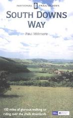
The walk is also covered in detail in the South Downs Way National Trail Guide, by Paul Millmore, ISBN 1 85410 966 9 published by Aurum Press Ltd.
The exception to this is at the end of the walk; when the A286 road is reached cross over it, and continue on eastwards up a surfaced road for a couple of hundred yards until Hillbarn Farm is reached. Here turn left, keeping some barns on the left along a track that starts to descend downhill to the north. The track passes an old quarry area at The Butts, before eventually ending at a road. Turn left along this road, passing Cocking Church on the right and then climbing up to meet the A286 in the village beside the post office. The Blue Bell Inn, where this walk ends, is a few yards away to the left.
Distances
| From | To | Distance (m) | Ascent (ft) | Descent (ft) |
|---|---|---|---|---|
| Wether Down | Queen Elizabeth Country Park | 4.1 | 400 | 676 |
| Queen Elizabeth Country Park | Beacon Hill | 7.9 | 1450 | 1056 |
| Beacon Hill | Hill Barn Farm | 5.5 | 676 | 1063 |
| Hill Barn Farm | Blue Bell Inn, Cocking | 0.7 | 16 | 220 |
This makes a total distance of 18.2 miles, with 2542 feet of ascent and 3015 feet of descent.
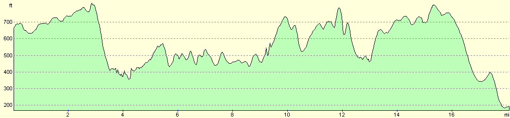
For more information on profiles, ascents and descents, see this page
Accommodation
I spent the night at the Blue Bell Inn in Cocking, which cost me Ł40.00 for the night. This was not the nicest place that I have ever stayed; the room was en-suite, but the radiator in my room stopped working (without my having touched anything) and the room was quite cold overnight. The address is: The Blue Bell Inn, Bell Lane, Cocking West Sussex GU29 0HN, telephone 01730 - 813449. There is also some camping available here as well.
Disclaimer
Please note that I take no responsibility for anything that may happen when following these directions. If you intend to follow this route, then please use the relevant maps and check the route out before you go out. As always when walking, use common sense and you should be fine.
If you find any information on any of these routes that is inaccurate, or you wish to add anything, then please email me.
All images on this site are © of the author. Any reproduction, retransmissions, or republication of all or part of any document found on this site is expressly prohibited, unless the author has explicitly granted its prior written consent to so reproduce, retransmit, or republish the material. All other rights reserved.
Although this site includes links providing convenient direct access to other Internet sites, I do not endorse, approve, certify or make warranties or representations as to the accuracy of the information on these sites.
And finally, enjoy your walking!
This walk was mentioned in the following routes:
| The South Downs Way |
Nearby walks
| # | Title | Walk length (miles) |
|---|---|---|
| 709 | South Downs Way: Winchester to Wether Down | 20.4 |
| 711 | South Downs Way: Cocking to Pulborough | 18.1 |
| 797 | A walk from Wickham to Old Winchester Hill | 23.1 |
|
|

|