Walk #456: Lendalfoot to Electric Brae
 |
 |
|
General Data
| Date Walked | 29/05/2003 |
| County | Strathclyde |
| Start Location | Lendalfoot |
| End Location | Electric Brae |
| Start time | 09.19 |
| End time | 17.43 |
| Distance | 20.8 miles |
| Description | This was a lovely and varied walk north through Girvan and Maidens, and passing the lovely Culzean Castle. |
| Pack | Today I carried my 30-litre Karrimor HotRock rucksack, which was filled with my packed lunch, waterproof leggings, water bottle and a couple of spare shirts, together with the usual assortment of odds and ends. |
| Condition | My feet ache slightly after today's walk, mainly because I was wearing my trainers and got them soaked. Aside from this I had very few troubles, although I was quite tired at the end of the walk. |
| Weather | This was the best day for some time, with lots of sunshine and no sign of any rain. The day was overcast at times and there was not much wind, so it got quite hot by the end of the day. It was really nice to have a warm day with absolutely no rain. |
| OS map | Landranger number 76 (Girvan, Ballantrae & Barrhill) and Landranger number 70 (Ayr, Kilmarnock & Troon) |
 |
 |
|
 |
 |
|
Map of the walk
Maps courtesy of Google Maps. Route for indicative purposes only, and may have been plotted after the walk. Please let me have comments on what you think of this new format. For a detailed table of timings for this walk, please see the table file.
 |
 |
|
 |
 |
|
Notes
After a few weeks where it has taken me four or five days to finish each Ordnance Survey map, it is nice to be able to finish a map in less than two days. This gives me a real feeling of progress, and this will be the position for the next few days as far as Glasgow. Unfortunately the downside of this good progress is the fact that I have to walk along roads, and this is a big problem, especially when they are busy main roads.
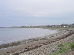
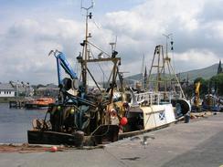
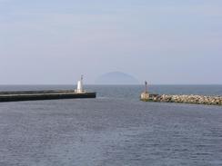
I made good time for the six miles north to Girvan, and I reached Mervan feeling quite good and ready for the rest of the walk. Sam was in the library in the town doing some research on the Internet, so I sat down and ate my sandwiches and wrote some notes up on my Psion, a nice relaxing change from the walk. Before I left Sam arrived, and we chatted for a few minutes before I left to look around the harbour. I was very surprised to see a seal in the water bobbing up and down between the boats, so I went back to fetch Sam so that she could see it. Apparently there are regularly five or six seals in the harbour, so it is far from an unusual sight.
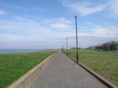
I walked through the town, which is quite nice, so that I could cross the river on the first bridge. On the other side I walked back to the sea and started following a path that was trapped between the sea and a golf course. As I was walking along I got a phone call from Sam, who was at a newspaper in the town, so I arranged to meet the reporters at the farm at Girvan Mains. To get there I had to walk inland slightly along a track, and I waited for a few minutes before they arrived. They turned up, and Sam arrived a few minutes later, and we had a very jovial chat before a few photographs were taken of me with the fields behind. One of the reporters actually did a very long walk in the Far East a few years ago, and we chatted about the ways and habits of long distance walkers.
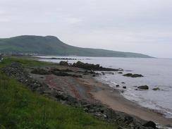
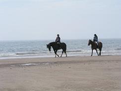
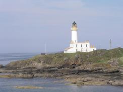
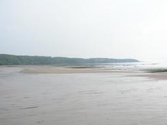
The next stretch of the A77(T) road heading north was so close to the sea that I chose to walk along this instead of along the low cliffs, as it allowed fast progress. When I reached Turnberry, however, the road moved away from the coast and so I diverted to the beach and walked along Turnberry Bay. Fairly soon there was a stream to cross, and in doing this I got my trainers absolutely soaked, which caused my feet to ache fairly soon afterwards. At the northern end of Turnberry Bay the sands finished, so I skirted the edge of the championship golf course northwards around Turnberry Point to the lighthouse. From here the cliffs were too near the holes for my liking, and so I decided that I would walk along the rocky foreshore under the cliffs rather than risk being hit by low-flying balls. Unfortunately this made the walk quite hard, and it was with relief that I reached the little pier at Maidens.
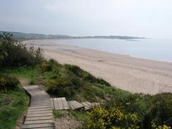
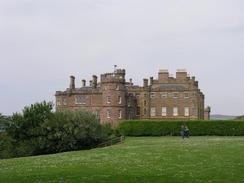
The next stretch of walk was through the grounds of Culzean Castle, and this was an absolutely superb little walk. There are a series of good tracks through the woodland, and I was surprised to find a lovely little lake and a pagoda through the trees. Near the castle is a set of small cannons, set up to repel French invaders (apparently this is the only remaining original earthworks of this type in the country). The castle itself looks absolutely lovely, and I wish that I had time to go and have a look around it. The master architect Robert Adam built it in 1777 for the Earl of Cassillis, and the castle displays a mix of Gothic and Georgian styles. Instead of walking around the castle I descended down to the boathouse, before heading under the castle along the rocky foreshore to reach Culzean Bay.
I ended today's walk at the weirdly named Croy Brae (otherwise known as Electric Brae). Sam was waiting for me in the lay-by by this famous stretch of road, and we sat for a few minutes watching cars stop and roll uphill, for that is what the stretch of road is famous for. It is quite a spectacular optical illusion, as the surrounding scenery makes a slow decline look like an incline. We could not really spend the night in he lay-by, so we chose to drive on into Ayr for the night. We spent the night on the roadside in the centre of the town, and this evening we went into a few local pubs to collect some money. A few pubs let us in (the manager of one club had heard me on Radio Scotland and let us in because of that), and people were generally very friendly and generous. In one pub, however, we got permission to collect, but the first man we went to started saying that we were taking liberties and should not collect from people. He seemed rather outraged and would not listen to any explanation that we were trying to give. Rather than create more of a scene, we decided the best thing was to leave. It is a shame that this happened, as I would not like to think that we are taking liberties or forcing people to give us money in any way. I think that I would much prefer to think that we met an unreasonable drunken Scot!
Directions
This walk starts off at a lay-by beside the A77(T) road in Lendalfoot. Turn lest and head northeastwards along the A77(T) road, passing a little memorial immediately outside the village. Continue northwards for about six miles, climbing up over Kennedy's Path before descending down to Ardwell Bay. The road was not too busy, and for most of the way the verge was wide enough to make the walk relatively safe. At Black Neuk the road has been diverted inland for a sort distance, but I walked along the old, windy section of road instead.
When a car park is reached to the south of Girvan enter the car park and head north along a footpath beside the sea. After two kilometres the harbour at Girvan is reached, and when this is reached turn right to walk past the harbour and on along the southern bank of the river until a bridge is reached. Cross the bridge and follow the northern bank of the river along until the sea is reached once more. Turn right and head north along a path that runs between the golf course and the sea, and when the golf course ends climb over a fence and follow the edge of a field until a track is reached. Turn right and follow this track southeastwards for a short distance as it passes through the farm at Girvan Mains and ends at the A77(T) road.
Turn left and walk north up the A77(T) road for about four miles, passing a factory at Dipple and reaching the southern end of Turnberry Bay to the southwest of Drumbeg. When I reached a short track that led west to a cottage by the sea I walked down it to gain access to the beach. Turn right and walk northwards along the beach until it ends near Turnberry Point, and then climb up along a path that skirts the edge of the golf course to the lighthouse. From here you could either walk along the edge of the cliffs northeastwards, but as this was too near some golf course holes I descended onto the rocky foreshore and walked northeastwards past Castle Port and Port Murray.
When the pier in Maidens is eventually reached head south along the pier until it joins a road, and then follow this around the edge of the harbour, and then join the beach. Walk northwards along the beach until it ends at Barwhin Point, and then turn to the right to climb up some wooden steps into the wooded Culzean Country Park. Make your way through the park towards Culzean Castle on good tracks; there is a cliff top path that gives occasional good views out to sea. Just before Culzean Castle is reached walk past some cannon and then, if the tide is low, turn left to head down to the boathouse. Note that if the tide is high then you will have to walk past the castle to get to the southern end of Culzean Bay. I descended down to the boathouse and then turned right to walk northward along the rocky foreshore to reach the southern end of the bay. Walk north along the beach for about a mile and a half towards Croy House, and then turn right to ascend the cliffs on a surfaced road. After about a kilometre the A719 road is reached; turn left and walk on for a few hundred yard until a lay-by is reached at Electric Brae, where this walk ends.
Distances
| From | To | Distance (m) | Ascent (ft) | Descent (ft) |
|---|---|---|---|---|
| Lendalfoot | Girvan | 6.8 | 328 | 322 |
| Girvan | Maidens | 8.6 | 495 | 502 |
| Maidens | Eletric Brae | 5.4 | 610 | 312 |
This makes a total distance of 20.8 miles, with 1433 feet of ascent and 1136 feet of descent.
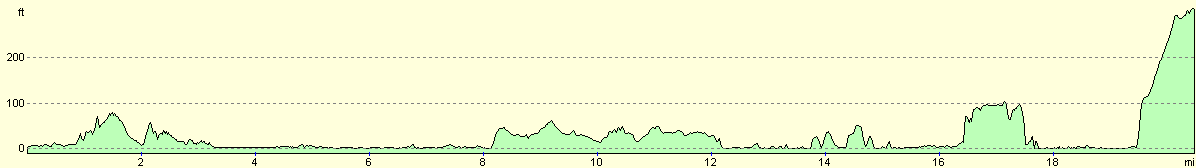
For more information on profiles, ascents and descents, see this page
Accommodation
We parked Mervan for the night in a side street in the centre of Ayr, about nine miles from where I finished the walk. This was handy for quite a few pubs, and was a relatively quiet place to spend the night.
Disclaimer
Please note that I take no responsibility for anything that may happen when following these directions. If you intend to follow this route, then please use the relevant maps and check the route out before you go out. As always when walking, use common sense and you should be fine.
If you find any information on any of these routes that is inaccurate, or you wish to add anything, then please email me.
All images on this site are © of the author. Any reproduction, retransmissions, or republication of all or part of any document found on this site is expressly prohibited, unless the author has explicitly granted its prior written consent to so reproduce, retransmit, or republish the material. All other rights reserved.
Although this site includes links providing convenient direct access to other Internet sites, I do not endorse, approve, certify or make warranties or representations as to the accuracy of the information on these sites.
And finally, enjoy your walking!
This walk was mentioned in the following routes:
| My walk around the coastline of Britain |
Nearby walks
| # | Title | Walk length (miles) |
|---|---|---|
| 455 | Cairnryan to Lendalfoot | 20.3 |
|
|

|