Walk #457: Electric Brae to Irvine
 |
 |
|
General Data
| Date Walked | 30/05/2003 |
| County | Strathclyde |
| Start Location | Electric Brae |
| End Location | Irvine |
| Start time | 08.22 |
| End time | 17.24 |
| Distance | 25.5 miles |
| Description | This was quite an enjoyable and varied day, with lots to be seen on the way. |
| Pack | Today I carried my 30-litre Karrimor HotRock rucksack, which was filled with my packed lunch, waterproof leggings, water bottle and a couple of spare shirts, together with the usual assortment of odds and ends. |
| Condition | I feel absolutely fine, if slightly fatigued, after this walk, and I was tempted to walk further if the bridge had been open. |
| Weather | The weather today was quite varied. Before I set off there was a heavy rainstorm, and as there were still black clouds overhead I started walking with my coat on. The sun soon came out, however, so I walked for the rest of the day without my coat on. At one stage after lunch I heard a thunderclap and there were black clouds overhead, and there were a few spots of rain but thankfully the main rainfall just missed me. Later on it became very hot, although the sky was exceedingly hazy. |
| OS map | Landranger number 70 (Ayr, Kilmarnock & Troon) |
 |
 |
|
 |
 |
|
Map of the walk
Maps courtesy of Google Maps. Route for indicative purposes only, and may have been plotted after the walk. Please let me have comments on what you think of this new format. For a detailed table of timings for this walk, please see the table file.
 |
 |
|
 |
Notes
5I am pleased to say that at 25.5 miles this was the longest day of the trip so far, and that I have not really suffered for it. Doing a twenty-five mile walk is quite good for me, especially as I have done so many long days recently. The fact that I have been doing such long days shows that I am getting fitter and more confident about the walk. In winter I was doing only 110 to 120 mile weeks, but recently I have been doing up to 150 miles - a large difference.
The weather today was totally mixed up - I was never unsure about whether it was going to rain or not, especially when there were black clouds overhead. Even when it was sunny the sky was quite hazy, which had an upside as it meant that I did not get too sunburnt. I wore my coat as far as Ayr as it had been raining on the drive back to Electric Brae, but the sun came out a few minutes after I started and I soon overheated. When I reached Ayr I left my coat in Mervan, and about ten minutes after I set off a black cloud came overhead and I heard a thunderclap. As I did not have my coat wit me I was worried that I would get soaked, but although there was some spitting the rain cloud just missed me.
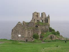
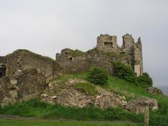
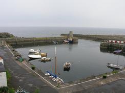
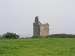
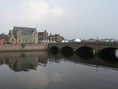
Early on in the walk I diverted into Dunure, as the road through the village was nearer to the sea than the main road. This was definitely worth doing, as it allowed me to have a quick look around the impressive ruins of the fifteenth-century Dunure Castle, which was the stronghold of the Kennedy clan. The castle is built on top of a low cliff, and although ruinous is still a nice structure. The harbour in the village was also quite picturesque, and it looked lovely in the early morning sun. A little later on I passed another ruined castle at Longhill Point to the south of Ayr - over the last few days I have passed at least one castle every day, which shows exactly how much this area was riven by strife and war in the past. A little further on I had expected to have to divert inland slightly to cross the River Doon, but fortunately a new pedestrian bridge has been built over the mouth of the river, and this allowed me to gain access to the promenade in Ayr easily.
I met Sam at a car park beside the promenade to the south of Ayr, and as I had already walked nine miles I decided to have an early lunch. We had a nice old natter for a while, and then I set off once more. No sooner had I done so than I got a phone call from a local newspaper, and we arranged to meet at the big top that was by the promenade. The reporter duly came, and we did a quick interview and she took some photographs before I went on my way once again. I am getting slightly better at dealing with the press the more interviews I do, and I no longer dread each interview. Radio interviews are still difficult, but I am finding them easier with time.
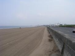
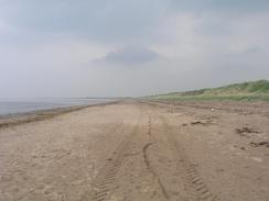
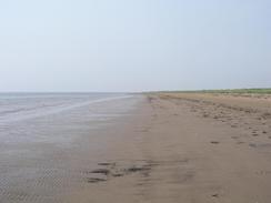
I decided not to take my life in my hand and cross the Royal Troon golf course, so I walked along the beach instead. This was a lovely, long stretch of sand and I enjoyed walking along it into the town. The town itself was quite nice, although I felt that I was the youngest person on the promenade by about thirty years! I walked over a large hill of ballast (built to protect the port) and then descended to an entrance to the port, before heading back towards the beach. From Troon I walked northwards along a large expanse of beach, which I highly enjoyed until about ten minutes from the end, when I tried to jump over a wide stream of water and got wet feet and trousers for my trouble!
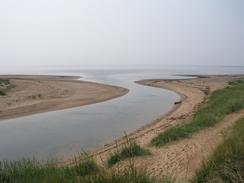
It was with some relief that I reached the car park at the mouth of the River Garnock in Irvine and I saw Mervan waiting patiently for me. As I approached I saw a bridge over the river that was not marked on my map, and I was instantly excited as a bridge over the mouth of the river could save me a very boring walk around the river via Kilwinnig and Stevenson. Unfortunately I could also see a gap in the bridge, although it did not look as though it was under construction. As I neared it I could see that part of it is on rollers, and hopefully it will be accessible in the morning so I can use it to cross the river. It had been built to allow access to the Big Idea complex on the northern bank of the river, and could be very handy for me.
Directions
This walk starts off beside the A719 road at Electric Brae. Continue northeastwards along the road for a mile until Dunure Mains is reached, and then turn left down the road that passes the castle and the harbour before climbing up through Fisherton and rejoining the A719 road. Continue on along the road, passing Lagg and the Head of Ayr farm park before a cycle path leads off down a surfaced path to the left, just before the road climbs up to go over an old railway bridge. This path heads northwestwards for a little under a kilometre, before turning to the right and heading eastwards parallel to the coast. After a car park on the left the path turns to the left and joins a short promenade along the coast that lead to a new bridge over the River Doon.
Cross the pedestrian bridge and join the promenade that head northwards for a couple of miles past Ayr. When the mouth of the River Ayr is reached turn right to head downstream past a new development of houses until the first bridge over the river is reached. Turn left to cross the bridge and then follow the cycle path northwards as it heads through the town and rejoins the coast. When the path heads to the right away from the coast continue straight on along a track that heads between a golf course and the sea until it joins a promenade on the south side of Prestwick. Follow the promenade northwards and when it ends continue on northwards along the beach. When the mouth of Rumbling Burn is reached turn right and walk inland for about half a mile to the first bridge over the burn, which is near to a caravan park; at low tide it may be possible to ford the mouth of the burn. Once across the bridge walk back towards the sea and then head northwestwards along the coast towards Troon.
On the southern outskirts of Troon either join the promenade or continue northwards alongside the beach. I followed the promenade until it joined the large ridge of earth called the ballast bank, and when this ended I descended down to a road, and then turned right to head past an entrance to the port, and then turned right to head back along the B749 main road. Near a roundabout I turned to the left to follow a track beside the beach eastwards past Pan Rocks. You then have two choices; you can either walk along the promenade through Barassie, or walk along North Sands. Whichever you do, at the northern end of Barassie you will have to join the beach, and walk north along that for another few miles until the mouth of the River Garnock is reached to the southwest of Irvine. Turn right and head into a car park, where this walk ends.
Distances
| From | To | Distance (m) | Ascent (ft) | Descent (ft) |
|---|---|---|---|---|
| Electric Brae | Ayr | 10.8 | 446 | 748 |
| Ayr | Troon | 9.8 | 233 | 230 |
| Troon | Irvine | 4.9 | 108 | 102 |
This makes a total distance of 25.5 miles, with 787 feet of ascent and 1080 feet of descent.
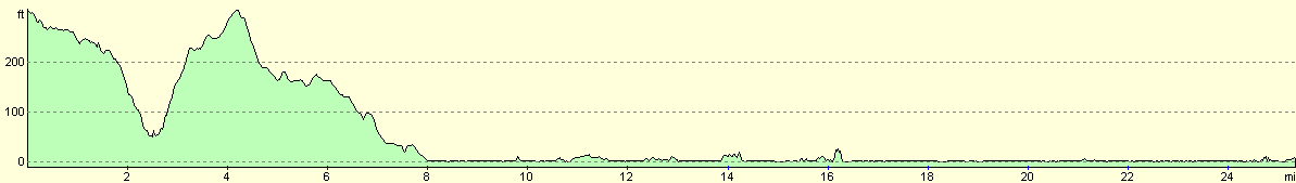
For more information on profiles, ascents and descents, see this page
Accommodation
We parked Mervan in the car park by the bridge over the River Garnock that leads to the Big Idea. There were some public toilets nearby, and we were both too tired to go to any pubs.
Disclaimer
Please note that I take no responsibility for anything that may happen when following these directions. If you intend to follow this route, then please use the relevant maps and check the route out before you go out. As always when walking, use common sense and you should be fine.
If you find any information on any of these routes that is inaccurate, or you wish to add anything, then please email me.
All images on this site are © of the author. Any reproduction, retransmissions, or republication of all or part of any document found on this site is expressly prohibited, unless the author has explicitly granted its prior written consent to so reproduce, retransmit, or republish the material. All other rights reserved.
Although this site includes links providing convenient direct access to other Internet sites, I do not endorse, approve, certify or make warranties or representations as to the accuracy of the information on these sites.
And finally, enjoy your walking!
This walk was mentioned in the following routes:
| My walk around the coastline of Britain |
Nearby walks
| # | Title | Walk length (miles) |
|---|---|---|
| 456 | Lendalfoot to Electric Brae | 20.8 |
|
|

|