Walk #111: Ancrum to Melrose
 |
 |
|
General Data
| Date Walked | 16/09/2000 |
| County | Borders |
| Start Location | Ancrum |
| End Location | Melrose |
| Start time | 07.30 |
| End time | 13.55 |
| Distance | 13.8 miles |
| Description | This was another pleasant day's walk, following St Cuthbert's Way, including a section alongside the River Tweed and a climb over the Eildon Hills. |
| Pack | Today I carried full Pennine Way kit. |
| Condition | I feel okay after this walk. I have stacks of energy left, despite climbing two of the summits in the Eildon Hills that I did not need to. My left calf gave me much less trouble than I had been getting yesterday, although it is still sore to the touch. The biggest problem of the day has been the middle toe on my left foot, which feels bruised. I shall apply plasters to it tomorrow morning to give it some extra protection. |
| Weather | A beautiful sunny day occurred today with initially very little cloud to be seen, maybe as little as 20%. There was quite a fierce wind, particularly in exposed places, and the temperature was not too high. Later in the day it started to cloud over, but again this caused no problems. |
| OS map | Landranger number 74 (Kelso & Coldstream, Jedburgh & Duns) and Landranger number 73 (Peebles, Galashiels & Selkirk, Tweed Valley) |
 |
 |
|
Map of the walk
Maps courtesy of Google Maps. Route for indicative purposes only, and may have been plotted after the walk. Please let me have comments on what you think of this new format. For a detailed table of timings for this walk, please see the table file.
Notes
This was an absolutely superb day. When I left the campsite I decided not to join Dere Street but to walk along he A68 which parallels it. Due to the petrol crisis traffic was light, and at the top of the first hill a superb panorama of the Eildon Hills became visible, and the range would become more and more visible as the day wore on.
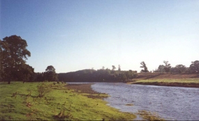
At Forest Lodge on the A68 I turned right for about a hundred yards to join Dere Street for the last couple of hundred yards. I then followed St Cuthbert's Way down to the Tweed, and then along the river to St Boswells.
In St Boswells I decided to rejoin the A68 instead of following St Cuthbert's Way alongside the river. Fortunately there was a pavement for the whole distance, so this was a safe if unspectacular stroll.
I stopped to have a five minute break under the old railway bridge in Newtown St Boswells, so I took off my pack and sat down. When I picked it up again later water was streaming out of my left balance pocket, so I assumed that my water container has burst. The walk up to Bowden was consequently slightly unpleasant as my left thigh and midriff were getting soaked from the water dripping out of the pocket.
After crossing the picturesque Bowden Burn I stopped in the lovely village of Bowden, where I had a piece of chocolate cake and a cup of coffee at a lovely little tearoom in the old school. As I waited for the coffee to arrive I checked the balance pocket and discovered that somehow the top had come off the water bottle, allowing about two thirds of the water to leak out. Fortunately this still left enough water for me to finish the walk, but I filled up my spare bottle anyway just in case.
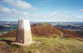
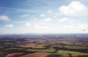
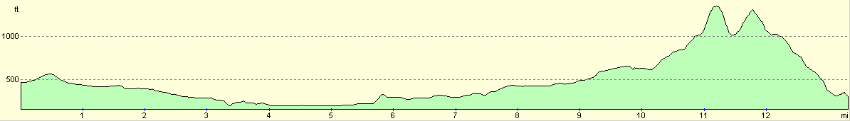
The walk up to the Col between Eildon North and Mid Hills was not as bad as I had been expecting, and navigation was easy along the forest tracks. When I reached the Col I dropped my pack into the heather and thus unencumbered climbed up to the top of Eildon Mid Hill (422 metres), where stupendous views could be obtained of all the surrounding area. The Cheviots were visible to the southeast, and the Lammermuir Hills were to the north, and hence I could see about four days worth of my walk from one point!
I then left Eildon Mid Hill, descended down to the Col and made the much easier climb up to Eildon North Hill, which is much flatter and slightly less high at 404 metres. The views were again marvellous, and I spent a few minutes at the summit letting the scenery soak in. I then descended back down to the Col, picked up my pack and made the mile walk into Melrose.
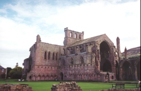
Melrose is a lovely little town, and I spent a couple of hours looking around it and the spectacular remains of Melrose Abbey. I also had a nice meal in a cafe, an experience that yet again showed up the friendliness of the Scottish people.
Directions
From the campsite at Liliardsedge Park I should really have gone back and joined the St Cuthbert's Way and Dere Street; instead I opted to walk along the A68(T) as it paralleled the footpath. Fortunately the road was very quiet, probably due to the fuel shortages that were beginning to bite.
I rejoined Dere Street at Forest Lodge and followed it for a couple of hundred yards to a minor road. I then turned right down this road and followed it as it crossed over an old railway line and into the little village of Maxton.
St Cuthbert's Way turns right along the A699 for a short distance before taking the first left turn downhill to the church. Pass the church and take a footpath that follows the southern bank of the River Tweed, initially ascending and descending the bank before settling to the valley floor and continuing onto Mertoun Bridge.
Follow the river around and through the grounds of a golf course. At the far end of the golf course the Way meets a road which is followed uphill to the B6404. Turn right along the B6404 and heads through St Boswells.
St Cuthbert's Way leaves the B6404 and follows the river along to Newtown St Boswells. I chose to continue on to the A789(T) and walk along the footpath north-westwards to Newtown St Boswells. Take the B6398 past a college and into the centre of the village. When you reach the centre at the bottom of the hill turn left and follow a road under an old railway bridge and up the hill, following the hillside to the south of Bowden Burn.
When the road curves around to the south at Whitlee head straight on through a gate and along a footpath on the southern side of the burn. The path soon drops down to the valley floor and crosses the Burn via a little footbridge. It then follows the northern side of the Burn and then leads uphill along a track and then a road to the village of Bowden.
Turn right along another road and then left up another one past a nice café. Head across fields and start the ascent up to the saddle between Eildon Mid and North hills. On the way up to the top of the hills the path enters an area of woodland as the ascent becomes steeper. A short distance after the path breaks out of the woodland the top of the saddle between the two hill summits is reached.
From here you can turn left and follow a steep track that leads up to the top of Eildon Mid hill, which commands wonderful views back to the Cheviots where I started this trip and northwards to the Lammermuir Hills which I shall reach the day after tomorrow.
A path also leads up from the saddle to the northeast to the fort on the top of Eildon North Hill. This fort was apparently present before the Romans, and the Romans took it over to be used as a watch point for the Fort and camps in the river valley to the northeast. Now unfortunately there is not much to see on the top of the hill except for wonderful views in all directions.
Once you have finished exploring the summits (I personally did not bother visiting the lowest, southernmost of the three summits) descend via well-worn paths to the north. This brings you out onto the B6359, which you can follow downhill for a short distance into Melrose and the end of St Curthbert's Way.
Distances
| From | To | Distance (m) | Ascent (ft) | Descent (ft) |
|---|---|---|---|---|
| Lilliardsedge Park | Maxton | 3.0 | 135 | 302 |
| Maxton | Newtown St Boswells | 5.0 | 479 | 436 |
| Newtown St Boswells | Melrose | 5.8 | 1496 | 1499 |
This makes a total distance of 13.8 miles, with 2110 feet of ascent and 2237 feet of descent.
For more information on profiles, ascents and descents, see this page
Accommodation
I stayed in the Melrose SYHA (Scottish Youth Hostel Association), which is in a very nice building in the centre of the town. It did not do evening meals, so I went into town to sample the delights of the local cuisine.
Disclaimer
Please note that I take no responsibility for anything that may happen when following these directions. If you intend to follow this route, then please use the relevant maps and check the route out before you go out. As always when walking, use common sense and you should be fine.
If you find any information on any of these routes that is inaccurate, or you wish to add anything, then please email me.
All images on this site are © of the author. Any reproduction, retransmissions, or republication of all or part of any document found on this site is expressly prohibited, unless the author has explicitly granted its prior written consent to so reproduce, retransmit, or republish the material. All other rights reserved.
Although this site includes links providing convenient direct access to other Internet sites, I do not endorse, approve, certify or make warranties or representations as to the accuracy of the information on these sites.
And finally, enjoy your walking!
This walk was mentioned in the following routes:
| My sectional Land's End to John O'Groats walk |
Nearby walks
| # | Title | Walk length (miles) |
|---|---|---|
| 110 | Morebattle to Ancrum | 13.6 |
|
|

|