Walk #803: Fareham to Bursledon
 |
 |
|
General Data
| Date Walked | 19/12/2007 |
| County | Hampshire |
| Start Location | Fareham car park |
| End Location | Bursledon station |
| Start time | 07.48 |
| End time | 16.16 |
| Distance | 23.5 miles |
| Description | This was a pleasant walk; initially walking down the eastern side of Portsmouth Harbour to Gosport, before joining the Solent Way and then up the River Hamble. |
| Pack | Today I carried my 30-litre Karrimor rucksack, filled with waterproofs, a book and other odds and ends. |
| Condition | I feel absolutely fine after this walk. |
| Weather | The day was bright and sunny, although quite chilly. |
| OS map | Landranger number 196 (The Solent & The Isle of Wight, Southampton & Portsmouth) |
 |
 |
|
 |
 |
|
Map of the walk
Maps courtesy of Google Maps. Route for indicative purposes only, and may have been plotted after the walk. Please let me have comments on what you think of this new format. For a detailed table of timings for this walk, please see the table file.
 |
 |
|
 |
 |
|
Notes
I really wanted to do this stretch of coastal walking again, as I had some fond memories of it from when I walked along it at the end of 2002. I had never been to Fareham before, and as I arrived the roads were busy. Eventually I came across signs for a long-stay car park, and I pulled up and purchased a ticket. It was only then that I realised that I was actually a good mile away from the station, which was where I wanted to start the walk. It did not seem necessary to move the car, so I packed my kit up and headed up through the car park to the High Street.
The walk through the centre of Fareham was surprisingly enjoyable; the pedestrianised stretch of the street had metal sculptures scattered along it, and market traders were setting out stalls. I reached the station, turned around and headed back the way that I had come. As I headed down towards the bus station a large, red sun was rising - a lovely sight. This continued as I approached Town Quay, where the sun was over the harbour. An underpass was painted with a jaunty nautical scene. All of this made Fareham far better than I had expected.
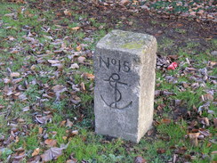
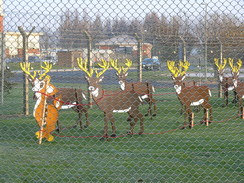
A pleasant walk followed through a park alongside the water, which eventually ended at a main road that I had to follow south past the large Royal Navy Armaments Depot at Bedenham. At least the military were in the Christmas spirit - through the fence by one of the gates into the complex was a Santa and sleigh, being pulled by a full complement of reindeer. The boundary of the depot was marked by a series of stone blocks, engraved with numbers and an anchor, which I believe donates the limit of military land.
Although thre was a pavement to walk along it was still a relief when I left the main road, and started following a road eastwards through Elson. Unfortunately I did not get a very good view of Fort Brockhurst, one of the 19th Century 'Palmerston's Follies'. Unlike many of the other defensice forts it is mostly intact, and is open to the public every so often.
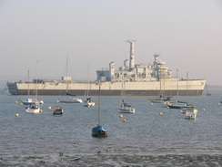
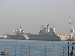
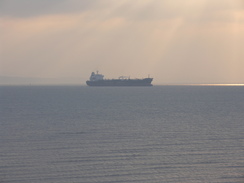
In Elson I joined the coast for a while, heading southeastwards. Here I got my first view of a military ship, what looked like a rusting cargo ship. A little further on were two more, grey warships laid up. The foreshore was muddy, and eventually I climbed up to walk along a road that paralleled the shore. I started to get better views of the warships. Some had obvious rust, and I guessed that they were not in use. One of my bugbears is the tragic way that the Royal Navy has been downsized massively over the last ten years (a situation that is only going to get worse as the number of ships we are building continues to decrease), and I wonder if we would even be able to fight another Falklands War.
A little further on was the Explosion! Museum, tracing the story of naval warfare over the last few Centuries. This led me onto the Haslar bridge over Forton Lake; this is a lift bridge, and a scissors lift was on it, and some men were working on the mechanism. They let me past, after telling me that in a few minutes they were shutting the bridge off for half an hour whilst they worked. It was kind of them, and I continued on past new housing development to reach the seafront by the ferry landing in Gosport.
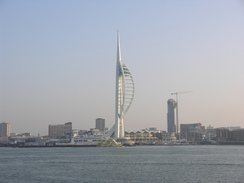
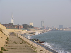
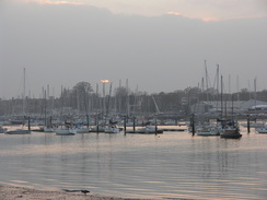
I could see across to the graceful Spinnaker Tower, designed to look like a large sail, and watched the ferries cross to and from from Portsmouth on the other side of the entrance to Portsmouth Harbour. Off to the left were two of our aircraft carriers - HMS Invincible is being sold to the Indians, and the remaining two ships are being forced to sail without any fixed-wing aircraft. This is a terrible example of how the Government is treating the Navy with contempt - an aircraft carrier without any aircraft!
I must admit I liked Gosport, for reasons I could not really say. Perhaps it was the history, the views over the water or the sunshine, or the gardens around the ferry landing. There was a memorial bust to Admiral of the Fleet The Lord Fieldhouse, just one of the many connections to the Navy. At the ferry landing I joined the Solent Way, which I would be following for most of the rest of the day. The next stretch took me along a road with a military hospital on the left; the large brick wall had occasional warning signs 'This is a Ministry of Defence road, Parking is not permitted.'
A path led towards the seashore just to the north of Fort Monckton, and I headed through a car park to reach this, hoping that there was a way past the fort to Gilicker Point. Unfortunately there was not; to the north was a jail, and to the south by the fort there were ominous-looking fences going down to the sea and cameras observing me. Fort Monckton is the main training centre for the SIS (MI6), which explains the fences. I had to walk back to the road and follow the Solent Way along a track past a golf course and two lakes to reach Fort Gilkicker.
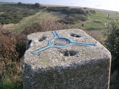
The fort is a Victorian structure designed to protect Spithead. It is in a semi-ruined state, and there are various plans to open it as a museum or build on the site. I walked past the gated entrance and walked around, before climbing up the steep slope to visit the trig pillar. Although the banking was not too high, there were some very good views to be had. A ferry worked its way across to the Isle of Wight, and Spitbank fort was easily visible out to sea.
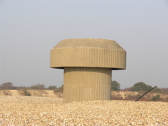
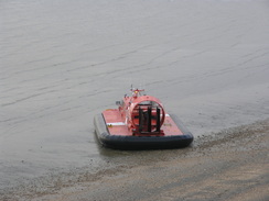
I clambered down and started following the beach up towards Browndown. This is a military area, but there were no red flags flying and so I proceeded on along the beach. A short distance away across the shingle beach there was a strange concrete mushroom-like structure. The camp has had a long association with hovercraft, and apparently the army use it for such purposes to this day. At the end of the camp I joined the promenade that headed through Solent-on-Sea, and from the promenade this seemed an attractive enough place.
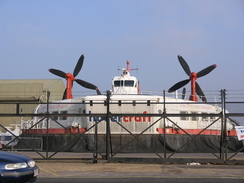
I diverted off the promenade for a short distance to climb up to the road to take some photographs of the < href="http://www.hovercraft-museum.org/" target="_blank">hovercraft museum, and some large craft were visible through the fence. Hovercraft fascinate me, and I would like to visit the museum sometime (this was turning into a day when I passed many things that I wanted to visit 'sometime in the future').
When the promenade ended I joined the beach for a while, and reached the tiny Hillhead Harbour, tightly packed with boats. Behind this were the lakes of Titchfield Haven, and I passed a little café and visitor centre. This was too tempting not to use, so I nipped in and had an omelette, which was absolutely delicious.
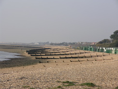
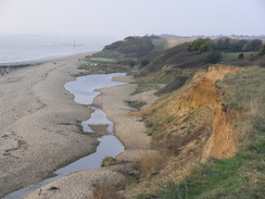
After the Haven the Solent Way clambered up onto cliffs for an enjoyable stroll, descending down to cross a stream before climbing once more to meet a trig pillar. Out to sea there was a hovercraft, and it would occasionally come onto the beach below the cliffs before roaring out to sea once more. The cliffs got lower as the path approached the Solent Breezes Caravan Site, and the rest of the path to the mouth of the River Hamble was not as pleasant as the last stretch. There were some interesting views over to the marine terminal at Fawley, which is related to the large oil refinery.
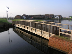
Eventually the path turned to the right to start heading up the east bank of the River Hamble. It passed a large pier with what looked like life rafts at the end, and then entered Warsash. On the wall of the rising Sun pub was plaque commemorating the 3,000 Commandos who sailed for the Normandy beaches on the evening of the 5th June 1944. I said a little prayer and continued on along the path.
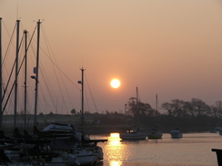
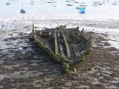
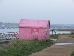
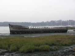
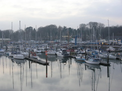
The River Hamble seemed to be covered in boats of all shapes and sizes, and I studied these as I passed the ferry landing, a small concrete hut painted in a garish shade of pink. Here the Solent Way was left behind as it took the ferry across to Hamble, but my route continued on up the eastern side of the river. As the sun was starting to go down I tried to put a spurt of speed on as I followed the good path northwards. The tide was out, and the orange sun glinted on the water and on pools that lay on the large expanse of exposed mudflats. There were a couple of half-rotted boats on the marshes, skeletal structures sticking out of the mud.
It was getting dark when I reached the main road, and I sped along the main road, making my way to Bursledon station. Unfortunately this was for nothing, and I had just under an hour to wait for the next train. I had a book with me, so I sat down in the lit shelter to read as I waited. When the train arrived in Fareham I had to walk back to the car from the station, another mile to walk, but one that I did on surprisingly light feet after a very enjoyable day's walk.
 |
 |
|
 |
 |
|
Directions
This walk starts off at the long-stay car park off the High Street in Fareham. The first part of this walk is to Fareham railway station; ascend up the sloping car park and go through an alleyway to reach High Street. Turn left to head downhill to the south for a hundred yards until it ends at a T-junction. Turn right, to start heading westwards along East Street. When this becomes pedestrianised continue on westwards through the centre of the town. After the pedestrianised area ends head straight on along West Street, and at a roundabout head straight on to ascend up to the railways station.
Leave the station and head back through eastwards through the town for half a mile until the pedestrianised area is reached; here turn right and follow West Street down towards a roundabout with the A27. Just before the roundabout is reached head straight on down a short road that ends at a footbridge. Climb this footbridge and use it to cross the A27 and adjacent railway line. On the other side follow the A27 southwards for a couple of hundred yards until Town Quay is reached on the left.
Here leave the road and start following roads and lanes southeastwards past the Quay. This then breaks out onto a footpath that follows the western side of Fareham Lake across a grassy area, passing Salterns Quay before starting to curve to the right. A narrow channel is reached on the left, and the northern edge of this is followed until the path ends at the A32 road.
Turn left to start following the A32 southeastwards for 1.7 miles, passing RNAD Gosport on the left. At a traffic-light controlled junction in Holbrook turn left to head eastwards along a road for three-quarters of a mile, heading immediately to the north of Fort Brockhurst. At a roundabout turn right to head southeastwards down another road for a couple of hundred yards towards Elson, and then turn left to join a footpath that skirts the foreshore all the way towards Priddy's Hard. When the Explosives museum is reached turn right along another road, and follow this as it immediately curves to the left to reach a footbridge over the Forton Lake.
Cross the footbridge and then head south down Weevil Lane until the A32 is reached. Turn left and follow the A32 southeastwards through Gosport for 0.4 miles until the road curves sharply to the right near the ferry landing. Leave the road and walk up to the ferry landing, and then turn right to start following the Solent Way southwards. A little harbour is crossed on a bridge, and then the path joins a road to cross Haslar Lake via the Haslar Bridge. Continue southwestwards along a road for half a mile passing a hospital on the left, and then take the first major road off to the left, Fort Road. Follow this as it curves to the right to head in a more westerly direction. After three-quarters of a mile turn left, still following the Solent Way, along a track that leads past two lakes on the left to reach the entrance to Fort Gilkicker.
At the entrance to the fort turn left and walk around to the southern edge of the fort, and continue along the Solent Way as it heads northwestwards along the foreshore. After a mile and a half Browndown is reached; when the road curves to the right continue on along the foreshore past Browndown Battery. There is a military danger area to the right, so you may need to make a diversion inland via the B3333 road to the north if the area is closed.
After 1.3 miles the danger area is left behind, and a promenade can be followed northwestwards through Lee-on-Solent. The Solent Way sticks close to the foreshore all of the way until Hillhead Harbour is reached. Jon the road to cross the bridge over the entrance to Titchfield Haven, and when this curves to the right continue straight on along a track. The Solent Way follows a footpath northwestwards along the top of the cliffs, and after a couple of miles the Solent Breezes Caravan Park is reached. The path passes on the seaward side of this, and after the park the path continues on for a little over a mile beside the sea towards Hook Lake and the mouth of the River Hamble.
Here the path turns to the right to start heading north along the eastern bank of the river. After three-quarters of a mile Warsash is reached; at the end of the road continue on northwards along a footpath that soon passes the ferry landing and continues on for a little over two miles until it ends at a main road in Lower Swanwick. It sticks to the riverside except for one small point where it diverts through a boatyard. At the main road turn left to start following the road northwestwards for a third of a mile as it crosses the River Hamble on a bridge, and on the other side turn left down a road that leads towards Bursledon. Take the first road off to the left, which heads for a hundred yards to Bursledon Station, where this walk ends.
 |
 |
|
 |
 |
|
Distances
| From | To | Distance (m) | Ascent (ft) | Descent (ft) |
|---|---|---|---|---|
| Fareham car park | Fareham station | 1.3 | 36 | 26 |
| Fareham station | Gosport ferry | 6.5 | 82 | 125 |
| Gosport ferry | Titchfield Haven | 8.2 | 167 | 161 |
| Titchfield Haven | Bursledon station | 7.5 | 328 | 318 |
This makes a total distance of 23.5 miles, with 613 feet of ascent and 630 feet of descent.
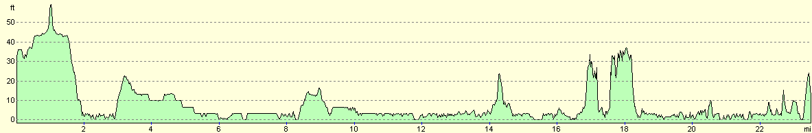
For more information on profiles, ascents and descents, see this page
Transport
There are regular (usually hourly) train services between Bursledon and Fareham.
 |
 |
|
 |
 |
|
 |
Disclaimer
Please note that I take no responsibility for anything that may happen when following these directions. If you intend to follow this route, then please use the relevant maps and check the route out before you go out. As always when walking, use common sense and you should be fine.
If you find any information on any of these routes that is inaccurate, or you wish to add anything, then please email me.
All images on this site are © of the author. Any reproduction, retransmissions, or republication of all or part of any document found on this site is expressly prohibited, unless the author has explicitly granted its prior written consent to so reproduce, retransmit, or republish the material. All other rights reserved.
Although this site includes links providing convenient direct access to other Internet sites, I do not endorse, approve, certify or make warranties or representations as to the accuracy of the information on these sites.
And finally, enjoy your walking!
Nearby walks
| # | Title | Walk length (miles) |
|---|---|---|
| 304 | Langstone to Tipner | 16.8 |
| 305 | Tipner to Browndown | 18.9 |
| 306 | Browndown to Bursledon | 12.9 |
|
|

|