Walk #306: Browndown to Bursledon
 |
 |
|
General Data
| Date Walked | 24/12/2002 |
| County | Hampshire |
| Start Location | Browndown |
| End Location | Bursledon station |
| Start time | 08.30 |
| End time | 13.46 |
| Distance | 12.9 miles |
| Description | This was a nice walk heading up Southampton Water towards Southampton. |
| Pack | Today I carried my 30-litre Karrimor HotRock rucksack, which was filled with my packed lunch, waterproof leggings, water bottle and a couple of spare shirts, together with the usual assortment of odds and ends. |
| Condition | I feel absolutely fine after this walk, which is to be expected after such a short walk. I feel slightly more fatigued than I normally do after a walk of this length, but that is probably due to the fact that I am slightly dehydrated after last night. |
| Weather | The weather today was very changeable, with cloudy periods being intermingled with short-lived drizzle showers and sunny periods. It was very mild for the time of year, and it felt more like spring than winter. It was quite windy, but this never really made me feel cold. All in all it was a reasonable day. |
| OS map | Landranger number 196 (The Solent & The Isle of Wight, Southampton & Portsmouth) |
 |
 |
|
 |
 |
|
Map of the walk
Maps courtesy of Google Maps. Route for indicative purposes only, and may have been plotted after the walk. Please let me have comments on what you think of this new format. For a detailed table of timings for this walk, please see the table file.
Notes
I woke up fairly early this morning, but could not really do anything as Sam was fast asleep beside me and Mike was comatose in the other bed. I waited a while before getting a book to read, and eventually Sam woke up. Unfortunately for her she was very much the worse for the drink that she had had last night, and she looked very rough. Eventually Mike also got up, and we had breakfast whilst we waited for dawn to come. They were both really suffering, so I was glad that I could leave directly from the campsite without Sam having to drive me anywhere in the van.
This morning I had a radio interview to do with Radio Solent at ten to eight. Since Sam was recording the interview I did not want to get any feedback, so I walked over to a telephone booth in the campsite so that I could talk. The interview did not really go very well, as I got the impression that the interviewer was not really interested in my answers, and it was also a very short interview. I am finding it easier to do interviews each time that I do them, and I am certainly less nervous than I have been for previous interviews.
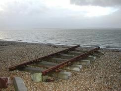
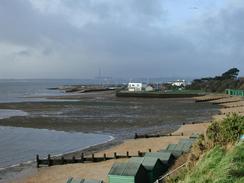
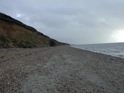
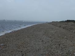
Between Hill Head and Warsash I alternated between walking on the foreshore below the cliffs and along the cliffs themselves. This went well until I reached a holiday camp that I managed to get totally lost in. I walked through the site to the other side, but I could not find any way through the fence, so I was forced to walk around to the entrance to the site and then go around from there. This probably added over half a mile onto the walk, and put me in quite a bad mood that did not ease until after I had a short stop. It was my fault that I got lost as I decided to press on through the site rather than following the footpath signs, but the fact that it was my fault angered me more than if it had not been.
Warash had a part to play in the D-Day landings, as Commandos embarked here for the journey over to France. On the riverfront here are a couple of memorials to the soldiers who took part in the landings, and I unsuccessfully tried to visualise what it must have been like to get on board the ships that would take them over to France, but I found it too hard. It is at times like this that the sacrifice that people of a couple of generations ago made for us really strikes me.
By the time that I reached Warsash I was feeling slightly fatigued, so I decided to nip into the Rising Sun pub, which is on the riverfront, for a drink. It was a very nice pub, and it was quite full. I had a long chat with a couple who were doing a little walk from Bursledon whilst I drank, and I just enjoyed the relaxing atmosphere in the pub. After I left I found it hard to get into the walk once more, and I felt like dawdling and looking at things rather than pressing on to the end. I wanted to finish relatively early as I wanted to give Sam some company, but I could not get my legs to go any faster.
Directions
This walk starts at the Kingfisher Caravan Park in Browndown. Leave the park and turn left along the road, crossing over the River Alver before reaching a roundabout. At the roundabout turn right for a hundred yards until the beach is met by a car park. If no red flag is flying then turn right and walk westwards along the beach past Browndown Point through the military base - if red flags are flying then you will have to walk inland along the B3333 past the base. When the base ends the B333 road comes in from the right to meet the base by the Elmore car park and a seawall begins.
Follow the seawall northwestwards along the seawall as it heads past Lee-on-the-Solent until the wall ends at a car park near Hill Head. Leave the car park via its exit and then turn left down Crofton Lane. At a T-junction turn left down Hill Head Road, which becomes Cliff Road as it progresses on and eventually becomes Meon Road as it descends down to the bridge over Titchfield Haven. Cross the bridge and on the other side either follow the beach if the tide is out or follow the path along the tops of the cliffs northwestwards. If you take the latter route then a caravan park on top of the cliffs is met; here a path leads around the park inland. Do not try to walk through the park as it is fairly confusing and I spent much time wandering around it.
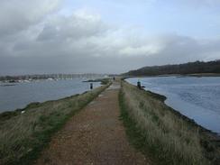
The path and beach continue on northwestwards before eventually turning to head northwards into Warsash. In the town join Shore Road and when it curves around to the right to become Passage Lane turn left up a footpath that carries the Solent Way. Pass the ferry terminal for ferries across the Hamble River and continue on along a narrow path that runs northwards along the eastern bank of the river. For the majority of the time the path runs along a narrow band of land with the river to the left and marshes to the right.
The path ends at Swanwick Shore Road by a car park. Join the road and follow it northwards until the A27 is met. Turn left along the A27 and follow it as it crosses over the River Hamble and then dives under a railway bridge. On the other side of the bridge turn left down Church Lane, and then take Station Road to the left that leads to the station car park, where this walks ends.
Distances
| From | To | Distance (m) | Ascent (ft) | Descent (ft) |
|---|---|---|---|---|
| Browndown | Hill Head | 5.0 | 115 | 112 |
| Hill Head | Warsash | 5.0 | 233 | 233 |
| Warsash | Bursledon | 2.9 | 89 | 75 |
This makes a total distance of 12.9 miles, with 437 feet of ascent and 420 feet of descent.
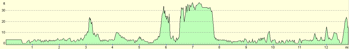
For more information on profiles, ascents and descents, see this page
Accommodation
We stayed at the Kingfisher Caravan Park, Browndown Road, Stokes Bay, Gosport, Hampshire PO13 9BG. They can be contacted on 023 9250 2611. This site was quite nice with some good facilities, although the grass between the pitches (which were all hard standing) was waterlogged, which they cannot really be blamed for. The showers were powerful and the toilet blocks warm, so all in all it was worth the eleven pounds that we paid to stay at the site.
Disclaimer
Please note that I take no responsibility for anything that may happen when following these directions. If you intend to follow this route, then please use the relevant maps and check the route out before you go out. As always when walking, use common sense and you should be fine.
If you find any information on any of these routes that is inaccurate, or you wish to add anything, then please email me.
All images on this site are © of the author. Any reproduction, retransmissions, or republication of all or part of any document found on this site is expressly prohibited, unless the author has explicitly granted its prior written consent to so reproduce, retransmit, or republish the material. All other rights reserved.
Although this site includes links providing convenient direct access to other Internet sites, I do not endorse, approve, certify or make warranties or representations as to the accuracy of the information on these sites.
And finally, enjoy your walking!
This walk was mentioned in the following routes:
| My walk around the coastline of Britain |
Nearby walks
| # | Title | Walk length (miles) |
|---|---|---|
| 304 | Langstone to Tipner | 16.8 |
| 305 | Tipner to Browndown | 18.9 |
| 307 | Bursledon to Southampton | 9.2 |
|
|

|