Walk #307: Bursledon to Southampton
 |
 |
|
General Data
| Date Walked | 25/12/2002 |
| County | Hampshire |
| Start Location | Bursledon station |
| End Location | Southampton (Ocean Village) |
| Start time | 08.00 |
| End time | 11.30 |
| Distance | 9.2 miles |
| Description | This was a nice walk on Christmas Day, heading north up Southampton Water into the centre of the city. |
| Pack | Today I carried my 30-litre Karrimor HotRock rucksack, which was filled with my packed lunch, waterproof leggings, water bottle and a couple of spare shirts, together with the usual assortment of odds and ends. |
| Condition | My angle ached a great deal towards the end of this walk. This was the first time in weeks that it had done so and I find it more than a little worrying. Hopefully it will be better for tomorrow's walk. |
| Weather | The weather today was truly excellent, and was more like spring than winter. It was sunny for most of the day with only occasional clouds and it was very mild at about twelve degrees. All in all it was a superb day for a walk, although it was not exactly a white Christmas! |
| OS map | Landranger number 196 (The Solent & The Isle of Wight, Southampton & Portsmouth) |
 |
 |
|
 |
 |
|
Map of the walk
Maps courtesy of Google Maps. Route for indicative purposes only, and may have been plotted after the walk. Please let me have comments on what you think of this new format. For a detailed table of timings for this walk, please see the table file.
Notes
It feels really strange to be walking on Christmas Day. This is the first Christmas Day that I have spent away from my family, and I did miss them - Christmas is not Christmas without them near me. It is Sam's fourth Christmas away from her family, and so I now understand how she feels at this time of year. Early in the morning the roads were very deserted, and not many cars passed me for the first hour or so. The only people I saw until later on in the morning were a couple of joggers, the ever-present dog walkers and a canoeist on Southampton Water. Everyone was in the Christmas spirit and in good cheer, and later on I saw children riding their new bikes whilst wearing their new Spiderman outfits!
As I walked over the Itchen Bridge I got a very good view of the Vosper Thornycroft yard in Southampton. There were two navy ships tied up alongside the yard and there were at least one more that I could see the top of in the town. The ships were quite impressive, and I wished that I could have had a look around them.
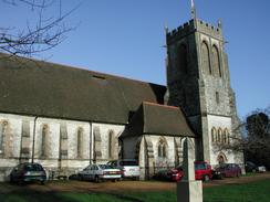
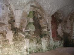
As I was passing through Netley I decided to divert slightly to have a look at the church, which was nice but not really that impressive. Right beside the church, however, was Netley Abbey, which was co-founded by Henry III. The ruins of this abbey were very impressive with many of the walls remaining to a high height. The reason for this was that the abbey was converted into a private house in Tudor times, which prevented it from being destroyed. I spent a good ten minutes looking around the abbey and taking photographs, and I was very impressed by the scale of the ruins.
I was considering extending the walk by not crossing the River Itchen and Itchen Bridge (the first crossing point) and walking up to Northam Bridge, the next bridge upstream. I decided against this as Sam phoned and said that she was bored (which is not a nice state to be in on Christmas Day) and my ankle was hurting. I therefore decided to meet her in Ocean Village, which meant that this was only the second walk on the whole trip when I have done less then ten miles in a day.
After the end of the walk we drove up to Salisbury to see two friends of Sam's, Dom and Emma, where we had a superb Christmas dinner with some lovely people. It was a really nice afternoon and evening, and we did not watch any television at all during the day, and I must admit that I did not miss it at all. By nine in the evening I was getting really tired, so I decided to go to bed, and Sam joined much later at about midnight.
Directions
This walk starts off in the car park of the station at Bursledon. Leave the car park and turn left to head uphil along a narrow lane called Station Hill that is blocked by bollards about twenty-five yards up. At the top of the hill the lane widens and then forks. Take the right-hand fork along a road called High Street and when it ends at a triangular junction by a red phone box turn left, still following High Street.
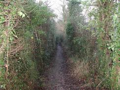
High Street passes The Vine Inn and the junction with Salterns Lane, where High Street becomes Kew Lane. When the road curves around to the right take a footpath that leads off beside a cottage and heads downhill before ending at another road. Follow this road and when it curves around to the right head straight on along another footpath that heads downhill. The footpath crosses an unsurfaced track and then becomes a bridleway that heads uphill through a wooded area.
At a fork in the path turn left, still following the bridleway, and do not take the footpath to the right. When the bridleway meets a surfaced track turn right along the track for about ten yards and then turn left, following the bridleway as it heads beside a chain-link fence and out of the trees. The path and fence both turn to the left and continues on, before crossing a track and then the railway line by a bridge before ending at a road called Satchell Lane.
Turn left down the road and follow it as it twists and turns as it heads in a general southerly direction into Hamble. The road does not have a pavement, so care is needed on some of the bends. Satchell Lane ends at a roundabout in Hamble, and at this roundabout turn right through the town for a short distance before taking the first road to the left down School Lane. When this road ends at a T-junction turn left, still following School Lane. When School Lane ends at a marina by Southampton Water enter a car park beside the riverbank.
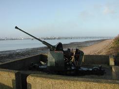
From the car park turn right past a Bofors anti-aircraft gun and take a footpath that leads on northwestwards. The path (called the Solent Way, which will be followed until the end of the walk) enters an area of brush land for a short distance before dropping down onto the foreshore and then climbing up onto the top of a seawall. The seawall passes under a jetty leading to a BP storage plant to the right and continues on until the seawall ends.
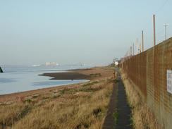
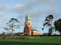
At the end of the seawall drop down onto the shingle beach and follow it as it heads northwestwards until it reaches the Royal Victoria Country Park. Here climb onto a surfaced path that parallels the foreshore as it heads northwestwards past the remains of the Netley military hospital,a brick-built chapel with a copper dome. Near the end of the park the path drops down to follow the top of the seawall until it ends at a little marina. Here turn to the right to join Victoria Road, which heads northwestwards through the village of Netley. Victoria Road becomes Abbey Hill near the ruins of the abbey before descending to meet the shore. Follow the road as it parallels the shore until it turns sharply to the right to head inland near a car park.
At the bend in the road continue straight on along a surfaced path that follows the beach as it continues northwestwards before turning to the right to head along the eastern bank of the River Itchen. Near a jetty the path ends at Victoria Road, which can be followed northwards past a large Vosper Thornycroft factory on the left (Note: 2018: the factory has been demolished and replaced with housing) before reaching some steps that lead up to the top of the imposing Itchen Bridge. At the top of the steps turn left and cross over the river using the bridge before taking some steps on the left that lead down to another road. Follow this road as it heads southwestwards towards Ocean Village and then turn left into Ocean Village, where the cinema car park where this walk ends is immediately on the right.
Distances
| From | To | Distance (m) | Ascent (ft) | Descent (ft) |
|---|---|---|---|---|
| Bursledon Station | Netley Church | 6.1 | 331 | 305 |
| Netley Church | Ocean Village, Southampton | 3.1 | 125 | 154 |
This makes a total distance of 9.2 miles, with 456 feet of ascent and 459 feet of descent.
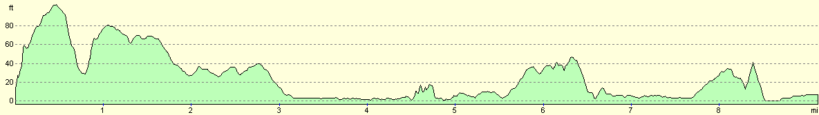
For more information on profiles, ascents and descents, see this page
Accommodation
We parked the van outside our friend's house in Salisbury, which meant a reasonably long drive to get there this afternoon and the same tomorrow morning when we have to get back to Southampton.
Disclaimer
Please note that I take no responsibility for anything that may happen when following these directions. If you intend to follow this route, then please use the relevant maps and check the route out before you go out. As always when walking, use common sense and you should be fine.
If you find any information on any of these routes that is inaccurate, or you wish to add anything, then please email me.
All images on this site are © of the author. Any reproduction, retransmissions, or republication of all or part of any document found on this site is expressly prohibited, unless the author has explicitly granted its prior written consent to so reproduce, retransmit, or republish the material. All other rights reserved.
Although this site includes links providing convenient direct access to other Internet sites, I do not endorse, approve, certify or make warranties or representations as to the accuracy of the information on these sites.
And finally, enjoy your walking!
This walk was mentioned in the following routes:
| My walk around the coastline of Britain |
Nearby walks
| # | Title | Walk length (miles) |
|---|---|---|
| 305 | Tipner to Browndown | 18.9 |
| 306 | Browndown to Bursledon | 12.9 |
| 308 | Southampton to Fawley | 16.4 |
|
|

|