Walk #308: Southampton to Fawley
 |
 |
|
General Data
| Date Walked | 26/12/2002 |
| County | Hampshire |
| Start Location | Southampton (Ocean Village) |
| End Location | Fawley |
| Start time | 09.15 |
| End time | 15.59 |
| Distance | 16.4 miles |
| Description | This was a boring road walk through Southampton that was followed with more road walks through Eling, Marchwood and Hythe to Fawley. |
| Pack | Today I carried my 30-litre Karrimor HotRock rucksack, which was filled with my packed lunch, waterproof leggings, water bottle and a couple of spare shirts, together with the usual assortment of odds and ends. |
| Condition | I feel absolutely fine after this walk, and have no problems to report. My ankle, which I had problems with yesterday, was fine today and did not ache at all. |
| Weather | It rained heavily all night, so I did not hold out much hope for a dry day today. This was a good thing, as I was not to be disappointed. I delayed the start of the walk by half an hour until a dry spell started, but within an hour it started pouring down. The rest of the day was a mixture of dry spells, showers and heavy rain, which meant that I got fairly wet today. It was a very mild day, however, so in the dry spells I dried out quite quickly, although there was not much wind to help this process. |
| OS map | Landranger number 196 (The Solent & The Isle of Wight, Southampton & Portsmouth) |
 |
 |
|
 |
Map of the walk
Maps courtesy of Google Maps. Route for indicative purposes only, and may have been plotted after the walk. Please let me have comments on what you think of this new format. For a detailed table of timings for this walk, please see the table file.
Notes
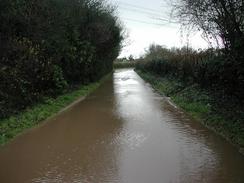
The main feat of today's walk was the weather, which can only be called bad. The rain had been falling for some time, and I had to contend with footpaths that were very boggy in places and even roads that were flooded over ankle deep all the way across the road, leaving me with little choice but to plough on through the water. In one of these places past Eling a car seemed to take great joy in speeding through the fifty-yard long puddle, drenching me with water in the process. This was not so bad as it could have been because I was already sodden on the outside, so a little extra did not make that much difference.
I had never been to Southampton before, so I was surprised to find that the city had walls. The first art of today's walk passed some of these medieval walls, and I enjoyed looking at the way they clashed with the modern architecture that was around them. There is a walk around the walls that can be done, but I decided not to do them, as I could not afford the time to do this. It was nice to see that many of the buildings around the remaining sections of wall had information boards or plaques on them, which is nice and made the walk through the town so much more interesting.
I have an old friend called Hilary who I knew from our time in university in London. Her parents live in Dibden Purlieu, and it was coincidental that I happened to be passing within a couple of miles whilst she was there (Hilary is flying out to Boston tomorrow, so it was very lucky that I was far enough ahead of schedule to catch her). We arranged to meet at Hythe Pier, so Sam and I had a look around the nice pier head (the pier has a railway running along it, which reminded me of Southend Pier). When she arrived we went into a nearby pub that was one of the few things open in the town on Boxing Day and had a good old chat - it was the first time in a couple of years that I had seen her.
When I was passing Dibden Church I decided to nip in to have a quick look around. The church is quite nice, but is nothing outstanding. This could be due to the fact that it was the first church in Britain to be destroyed in the Second World War after incendiary bombs hit it on the morning of the 20th of June 1940. The church was restored in 1955, although the north and south aisles were not rebuilt. During the fire in 1940 the bells fell from the tower and damaged the font, which dates from around 1200, but this was later rebuilt. The bells themselves were destroyed, but new ones were cast from the metal of the old ones.
Directions
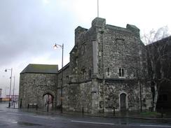
This walk starts off in the car park of the cinema in Ocean Village in Southampton. Leave the car park and turn left to head a short distance to Canute Road. Turn left down Canute Road and cross over a railway line that leads into the docks on the left and continue on until Canute Road ends. Head straight on down Platform road past the fifteenth century God's House Tower, where the road becomes Town Quay. God's House Tower is part of the city walls, which continue near the road until a roundabout is reached. At the roundabout continue straight on along the dual carriageway West Quay Road.
There is no pavement beside West Quay Road, but the verge was wide enough to allow me to walk easily. When Mountbatten Way comes in from the right cross Mountbatten Way and continue on as the road swings to the left to climb up onto a bridge over the railway line. On the other side of the bridge climb the steps onto a pedestrian footbridge beside Millbrook Station that allows you to access the other, left-hand side of the road. Continue on along the left-hand side of the road as it passes two roundabouts, the first giving access to the A35 and the second one the M271.
After the second roundabout the road rises up to climb onto a bridge over the River Test before descending down and then rising up to a bridge over the Southampton to Bournemouth railway line. Along this stretch of road there is a cycle path that allows the road to be negotiated safely. The road passes to the right of a chemical plant before a cycle path branches down to the left, signposted for Eling and Marchwood. At the bottom of this path Eling Lane is met. Turn left down Eling Lane and follow it as it curves to the right to cross Bartley Water on a toll bridge beside a tidal mill.
On the other side of the bridge the road climbs up past Eling Church and the Village Bells Pub, where the road becomes Bury Lane. When Bury Lane ends at a T-junction a short distance later turn left down Marchwood Road. This road heads southeastwards and as it passes Bury Farm it becomes Bury Road. When a roundabout to the northwest of Marchwood is reached turn left down Normandy Way that curves around the northern part of the village. When Cracknore Hard Lane is reached on the left the road becomes Main Road and curves aouthwestwards through the village past St John the Baptist Church and cross a level crossing over a railway line.
Past the level crossing the road swings around to the left and becomes Hythe Road. This roughly parallels the A326 road as it heads southeastwards out of Marchwood. Shortly after Church Farm Close on the left turn left along a footpath that heads uphill across a field before entering the churchyard of All Saints Church. In the churchyard join a surfaced path that leads out to a little track. Turn right down this track for a couple of hundred yards until it ends at Main Road. Turn left down Main Road and follow it as it heads eastwards past Lock's Farm and the Dibden Golf Centre.
The road becomes Southampton Road as it approaches Hythe, and take the first road to the left, West Street, that crosses over the railway line before turning sharply to the right before becoming St John's Street as it passes the pier and then Shore Road. Continue along Shore Road as it passes to the right of RAF Hythe before the road curves to the right to cross over the railway line and become Frost Lane.
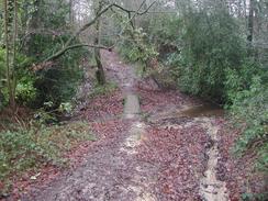
As the road curves to the left turn left down Hart Hill, following the Solent Way path. This surfaced lane becomes increasingly rougher as it passes the Travellers Rest pub until it becomes a muddy track as it crosses a stream at the bottom. It then climbs uphill and continues southwards and becomes surfaced once more. The surfaced road ends at the Esso Hythe Terminal where the bridleway continues on the right, skirting the depot's fence before ending at a surfaced road by the entrance to the depot. Turn right down this road and follow it for a short distance until it ends at a public road. Cross over the road and take the left most of two tracks that continues on for a short distance until it meets the A326 road.
Turn left and follow the A326 road as it heads southeastwards for about a mile until a roundabout with the B3053 is reached. At the roundabout turn left down the B3053 and follow it for a little over a kilometre into Fawley. In Fawley take the first road to the left, Church Lane, that heads northeastwards to the church in Fawley, where this walk ends.
Distances
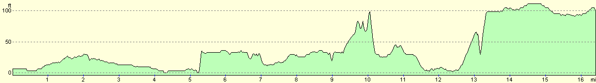
| From | To | Distance (m) | Ascent (ft) | Descent (ft) |
|---|---|---|---|---|
| Southampton | Totton | 4.8 | 62 | 66 |
| Totton | Hythe | 6.8 | 249 | 249 |
| Hythe | Fawley | 4.8 | 194 | 98 |
This makes a total distance of 16.4 miles, with 505 feet of ascent and 413 feet of descent.
For more information on profiles, ascents and descents, see this page
Accommodation
We parked on the roadside on a road near the church, which means that I will be able to start the walk in the morning without Sam having to move the van.
Disclaimer
Please note that I take no responsibility for anything that may happen when following these directions. If you intend to follow this route, then please use the relevant maps and check the route out before you go out. As always when walking, use common sense and you should be fine.
If you find any information on any of these routes that is inaccurate, or you wish to add anything, then please email me.
All images on this site are © of the author. Any reproduction, retransmissions, or republication of all or part of any document found on this site is expressly prohibited, unless the author has explicitly granted its prior written consent to so reproduce, retransmit, or republish the material. All other rights reserved.
Although this site includes links providing convenient direct access to other Internet sites, I do not endorse, approve, certify or make warranties or representations as to the accuracy of the information on these sites.
And finally, enjoy your walking!
This walk was mentioned in the following routes:
| My walk around the coastline of Britain |
Nearby walks
| # | Title | Walk length (miles) |
|---|---|---|
| 306 | Browndown to Bursledon | 12.9 |
| 307 | Bursledon to Southampton | 9.2 |
| 309 | Fawley to Bucklers Hard | 15.4 |
|
|

|