Walk #309: Fawley to Bucklers Hard
 |
 |
|
General Data
| Date Walked | 27/12/2002 |
| County | Hampshire |
| Start Location | Fawley |
| End Location | Bucklers Hard |
| Start time | 07.15 |
| End time | 12.32 |
| Distance | 15.4 miles |
| Description | This was a nice walk, finally leaving Southampton Walking and joining the Solent for a short distance before heading up the Beaulieu River. |
| Pack | Today I carried my 30-litre Karrimor HotRock rucksack, which was filled with my packed lunch, waterproof leggings, water bottle and a couple of spare shirts, together with the usual assortment of odds and ends. |
| Condition | I feel absolutely fine after this walk, and I had no major problems to report. I had a few little aches from my ankle, but I tightened up my boot severely and this stopped it. |
| Weather | It was overcast all day, but fortunately there was no rain whilst I was walking. It was another mild day, and there was not much wind to spoil the day. I was fairly lucky as it absolutely poured down whilst we were in the museum this afternoon, and I managed to miss all of the rain. |
| OS map | Landranger number 196 (The Solent & The Isle of Wight, Southampton & Portsmouth) |
 |
 |
|
 |
 |
|
Map of the walk
Maps courtesy of Google Maps. Route for indicative purposes only, and may have been plotted after the walk. Please let me have comments on what you think of this new format. For a detailed table of timings for this walk, please see the table file.
Notes
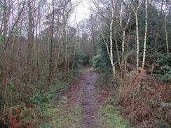
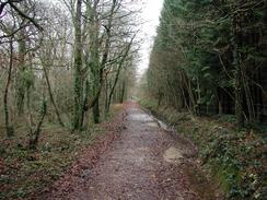
Both Sam and myself wanted to visit the National Motor Museum, which is at Beaulieu, about three miles away from where I ended this walk. I did not want to do a very short day, so I decided that I would set off before first light in the morning. As I walked the short distance to the church in Fawley from where we had parked on the roadside I could see that the church was lit up with spotlights, making it a truly beautiful sight. Later on as I walked along the footpath from Ashlett I could see the lights from the oil tankers berths in the river glinting magnificently in the water. Unfortunately in places the path was waterlogged and even flooded, which meant that my feet got wet as I waded through these patches. It was lovely to be walking as the sun was coming up, although I was quite paranoid about hurting my ankle on unseen rough ground.
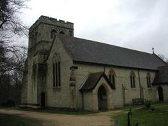
St Katherine's Church in Exbury was open, so I went in for a look around. This is quite a nice little church and I enjoyed studying it was I wandered around. One item in particular - there is a raised tomb dedicated to two soldiers who died in the First World War. It is nice to see a traditional-styled tomb that has been built fairly recently, and the supine statue on top of the tomb had clothes of the era on. It was quite a nice sight, and I read the plaques around the tomb before I left.
Bucklers Hard was a lovely little place and was a quiet and peaceful place as I walked through. It is hard to believe that this was the place was a hive of shipbuilding activity as recently as the Second World War. Warships were built here for nearly a century from 1698, including Nelson's favourite ship, HMS Agamemnon. Shipbuilding ceased until the Second World War, when motor torpedo boats and sections of Mulberry Harbour were built along the Beaulieu River. There were also some Special Operations Executive bases nearby, so the area was a hive of secret activity during the war. Today the place is sylvan, with a museum dedicated to the history of the place.
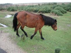
Whilst walking northwestwards from Exbury I entered the New Forest, and I saw my first New Forest ponies. These were walking across the road stopping what little traffic there was, and they looked lovely despite the fact that they were bedraggled. I love horses but I have always had trouble with them - whenever I get on one I always seem to be off it within a few minutes. When we parked the van this evening in East Boldre there were some more ponies wandering around and along the road.
The National Motor Museum was absolutely superb, and we enjoyed going around it. I am far from being very knowledgeable about cars, but it was nice to be able to go around and put images to names that I have heard over the years - Talbot Sunbeam, Ferrari F40, and so on. The highlight for me had to be Bluebird, the car in which Donald Campbell took the World Land Speed Record. It is a truly beautiful, and more of a sculpture than a car, with the streamlining looking absolutely superb. Sam liked the fact that it had an Australian flag as well as a British flag - a sign that the record had been set on a lakebed in Australia. Going to the museum got me away from the routine of the walk and allowed me to recharge my batteries, which is something that I think that I needed.
Directions
This walk starts off at Fawley Church. Turn left down Marsh Lane for about a hundred yards before turning to the left down Church Lane. Take the second road to the left, Copthorne Lane, and when this road turns to the left turn right to follow another road. This road curves around before it forks. Take the left-hand fork and follow the road as it passes to the left of a white house and descends downhill to the Jolly Sailor pub in Ashlett.
At the pub turn right through a gate and down a track that then turns to the left to reach a marina. When the track enters the marina at a cattle grid turn right and walk across a field. This path meets the shore and continues into an area of sparse woodland where a better path leads onwards to the southeast towards the large power station. When it meets a chain link fence guarding the power station that path turns left alongside the fence for a short distance before turning to the right. The path passes the power station before crossing an inlet using a heavily fenced footbridge before the chain link fence ends on the right. When this happens continue straight on down a track until it reaches a road beside the beach and some brightly coloured beach huts to the northeast of Calshot.
Turn right to walk southwestwards along the road towards Calshot. When the road meets a car park continue straight on up a little hill and follow the road as it turns to the right. Follow the road around to the right and into a little area of housing. Near the brow of a hill turn left down Tristian Close and then turn right down a short little access road. At the end of this road a gap in the fence allows access to a footpath.
Turn left along this footpath and follow it as it heads westwards through an area of trees until it ends at Stanswood Road. Turn left down this road and follow it as it heads southwestwards past Stanswood Farm until it ends at a T-junction with Lepe Road. Turn left to head southwards down another road for a kilometre until the car park beside the sea at Stone Point is reached.
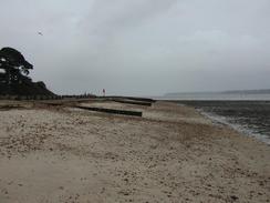
The road curves around to the right by the car park to head westwards towards Lepe. When the road moves to the right continue straight on to the west along a footpath that runs along the top of the seawall to the right of a white house. When the seawall ends the path continues on along the beach below some low cliffs past Inchmery House before it meets the road once again. This path may be impassable at high tide; it was not a nice path to walk along even when the tide was low. When the path meets the road once more turn left along it and follow it as it swings to the right to head northwards for a mile to the church at Exbury.
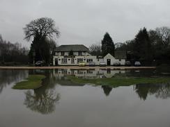
Continue on as the road heads northwestwards through a pleasant wooded area, passing the Forestry Commission Moonhill car park before ending at a T-junction with another road. Turn left down this road for about fifty yards to another T-junction with the B3054 road beside the Royal Oak pub. From here, the route follows the Solent Way for the rest of the day. Turn left and head southwestwards down the B3054 road for a mile into Beaulieu. Cross the bridge over the river and then take the first road to the left, called Fire Station Lane.
The lane becomes narrower until it eventually becomes a path that heads uphill before entering Keeping Copse. The path is very well signposted and it would be hard to get lost. As the path leaves the Copse it joins another track that heads south past some moored boats to the marina at Bucklers Hard. Cross the marina access road and turn half-left down a footpath that heads for a hundred yards to the riverbank. Turn right along the riverbank along the path and then when some buildings are reached on the right turn uphill. When the houses on the left finish turn to the left and pass the museum. The car park where the walk ends is immediately on the right.
Distances
| From | To | Distance (m) | Ascent (ft) | Descent (ft) |
|---|---|---|---|---|
| Fawley | Lepe | 6.3 | 115 | 213 |
| Lepe | Beaulieu | 6.6 | 161 | 161 |
| Beaulieu | Bucklers Hard | 2.5 | 135 | 89 |
This makes a total distance of 15.4 miles, with 411 feet of ascent and 463 feet of descent.
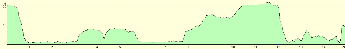
For more information on profiles, ascents and descents, see this page
Accommodation
We decided that parking in Beaulieu would be too difficult as it is such a small place, so we drove to East Boldre and parked on the roadside there. This was a reasonable place to spend for the night except for some motorbikes being ridden noisily along the street this evening.
Disclaimer
Please note that I take no responsibility for anything that may happen when following these directions. If you intend to follow this route, then please use the relevant maps and check the route out before you go out. As always when walking, use common sense and you should be fine.
If you find any information on any of these routes that is inaccurate, or you wish to add anything, then please email me.
All images on this site are © of the author. Any reproduction, retransmissions, or republication of all or part of any document found on this site is expressly prohibited, unless the author has explicitly granted its prior written consent to so reproduce, retransmit, or republish the material. All other rights reserved.
Although this site includes links providing convenient direct access to other Internet sites, I do not endorse, approve, certify or make warranties or representations as to the accuracy of the information on these sites.
And finally, enjoy your walking!
This walk was mentioned in the following routes:
| My walk around the coastline of Britain |
Nearby walks
| # | Title | Walk length (miles) |
|---|---|---|
| 305 | Tipner to Browndown | 18.9 |
| 306 | Browndown to Bursledon | 12.9 |
| 307 | Bursledon to Southampton | 9.2 |
|
|

|