Walk #310: Bucklers Hard to Milford on Sea
 |
 |
|
General Data
| Date Walked | 28/12/2002 |
| County | Hampshire |
| Start Location | Bucklers Hard |
| End Location | Milford on Sea |
| Start time | 08.00 |
| End time | 15.04 |
| Distance | 19.0 miles |
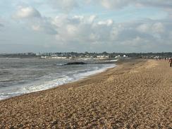
| Description | This was a walk of two halves; a long road walk to Lymington was followed by a nice seawall and shingle beach walk to Milford on Sea. |
| Pack | Today I carried my 30-litre Karrimor HotRock rucksack, which was filled with my packed lunch, waterproof leggings, water bottle and a couple of spare shirts, together with the usual assortment of odds and ends. |
| Condition | I am absolutely fine after this walk, and I could easily have walked further after a little rest if I had needed to. I did have a little trouble with my ankle early on in the walk (see text below) but this went away. Yet again I have no blisters, and no other part of my body found this walk hard. |
| Weather | Today's weather was absolutely superb - it was fairly mild for the time of year and the sky was mostly sunny with only slight cloud. This made for a wonderful day to do some walking, although in exposed places the wind was annoying although not troubling. |
| OS map | Landranger number 196 (The Solent & The Isle of Wight, Southampton & Portsmouth) and Landranger number 195 (Bournemouth & Purbeck, Wimborne Minster & Ringwood) |
 |
 |
|
 |
 |
|
Map of the walk
Maps courtesy of Google Maps. Route for indicative purposes only, and may have been plotted after the walk. Please let me have comments on what you think of this new format. For a detailed table of timings for this walk, please see the table file.
 |
 |
|
 |
 |
|
Notes
At St Leonards Grange early on in the walk there was a massive stone gable end wall on the inside of the bend. This wall dwarfed the barns that were inside the area, and I wondered what it could have been. It was very rudely constructed so I doubted that it could have been part of a church, but there was a tithe barn marked on the map so I can only assume that it was part of that. A little further on there was an information board beside the road that marked the site of a little airfield, or advanced landing ground, that was built in 1943. There is absolutely no sign of the airfield any more, and it is hard to believe that one of the runways even crossed the road. The small but important base became the home for over 100 Hawker Typhoon fighter-bombers, and there were four blister hangers built. By the end of July the planes had all moved to airfields that had been constructed in Normandy, thus ending the use of the airfield.
By the time that I reached Keyhaven I was quite desperate to go to the toilet so I nipped into quite a smart pub and restaurant called the Mayflower that had a distinctly nautical theme. I had a nice conversation with the staff there and read one of the newspapers that were by the bar whilst I supped my pint. This break allowed me to recharge my batteries and marked the boundary between the road walking and footpath sections of the walk.
It is annoying that there are no footpaths south from Bucklers Hard to the sea and then along the coast, as I was forced to do a long road walk with only occasional glimpses of the sea being visible from the road. It would have been a much better walk if there was a footpath around the coast for this section, but unfortunately there is not. There are some estate roads further towards the coast, but as these are not public roads and would have involved doing some large loops I decided against walking along them.
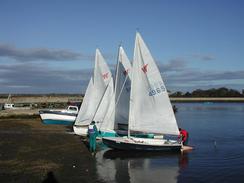
I had arranged to meet Sam in Milford on Sea, and by the time I reached Keyhaven I was feeling fit and willing to extend the walk. Since it was such a lovely sunny day I decided to extend it by walking down Hurst Beach to Hurst Castle and then back again. This was a very pleasant walk with the Isle of Wight and the Needles very visible, but I hated the fact that it was along shingle. The trip to the castle seemed to last forever over the partially compacted shingle, but the journey back flew by as I listened to a play on Radio Four and the sound of my boots on the shingle was quite entrancing.
I had some more trouble with my ankle today, but of a curious kind. When I first started having trouble with it when I was near Rochester I thought that it was actually my little toe giving me trouble (since the nerves are mucked up in my left ankle I sometimes get sensations in strange places in my foot). Today I was getting exactly the same sort of sensation - a sharp pain in my left ankle whenever I tried to move my little toe upwards. This was slightly stunting my progress, so when I got to the pub I took my left boot off and rearranged the seam of the sock so that it was no longer pressing on the toe. About half an hour after I restarted the walk I no longer had the problem and my ankle was absolutely fine, which is leading me to believe that the problem is more with my little toe than my ankle.
Having just seen the start of the South West Coast Path this afternoon I am incredibly keen to start the walk on that particular long distance trail as I have been looking forward to it for the entire trip so far. I should be starting it at the start of the New Year in a few days, as I have to get around Poole Harbour before I get there, but I really want to start it now. I guess patience will be a virtue that I shall have to show over the next few days. Of course the South West Coast Path also marks the start of some very hard walking, so in a few weeks I could be looking back with fondness to the flat seawalls of Essex!
Around Sowley there were lots of ponies on the roadside, all of whom looked very bedraggled and wet. I am really quite enamoured by the fact that ponies are allowed to roam freely along the roads, and cannot help but thin that other areas of the country would benefit from having them roam freely, but of course they have undesirable side effects for traffic.
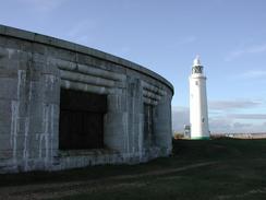
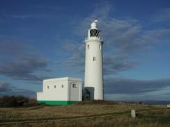
Hurst Castle was very impressive, and in style it somewhat reminds me of some of the Thames Forts that I saw a few weeks ago. It was initially built by Henry the Eighth to defend the Solent, but was extensively modified in the 1960's. I did not really want to pay the money to go into the castle to look into the exhibition when I would have to hurry around it, so with regret I turned away and walked back along the long spit.
Directions
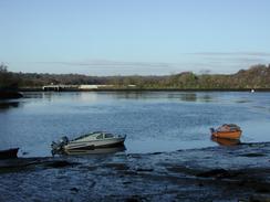
This walk starts off at the car park at Bucklers Hard, near the western bank of the River Beaulieu to the south of Beaulieu. Leave the car park and join the access road that ends at a bend in a public road. Turn left and follow the road southwards. When a T-junction is reached turn left towards St Leonards, where the road turns sharply to the right beside a large and imposing stone gable end wall.
The road then heads in a a roughly westerly direction, passing the entrance to the Log House and the site of an old airfield that has nice views toward the Solent and the Isle of Wight. Shortly after a road leads off to the right take a road to the left, signposted Sowley Lane, that heads southwards before turning southwestards towards Sowley House.
From Sowley House the road passes to the south of Sowley Pond before reaching a road junction after another mile. At the junction follow the road as it swings around to the right and after a couple of hundred yards take the first road to the left. This road continues towards South Baddesley and after a couple of kilometres turn left down Shotts Lane towards Lisle Court, where the road turns sharply to the right to head westwards and becomes Lisle Court Road.
The road descends to a road junction, where you turn left towards a car park beside Lymington Ferry Station. Here the road turns to the right and heads northwards through Walhampton before ending at a T-junction with the B3054 Bridge Road. Turn left along Bridge Road and cross the bridge over the Lymington River and then the railway line over a level crossing before entering the town.
When a mini roundabout is reached turn to the left to head southwards through the town along Gosport street. When the road turns to the right continue straight on down Captains Row that fairly soon turns to the left and then the right to head southeastwards along Bath Road past a marina. Follow the road as it curves around to the right by a car park and the lifeboat station until the Mayfower pub is reached on the left.
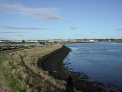
Immediately past the pub turn left down a road and follow it for a couple of hundred yards. When the road curves to the right turn to the left along an entrance driveway to Lymington Yacht Haven. Follow the driveway as it curves to the left and then the right before joining a sea wall to the left.
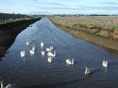
Follow this sea wall as it curves around an area of marshes that is a nature reserve. The path winds in and out before crossing a slightly triangular creek by a sluice. Eventually the path settles on a south-westerly course before curving around to enter Keyhaven.
In Keyhaven the path along the sea wall ends at a narrow car park beside a road. Turn left and walk westwards along this road for a short distance until the footpath and sea wall turns off to the left once more. Follow the footpath around for another kilometre until a road is met before a wooden footbridge leads off over a stream straight ahead.
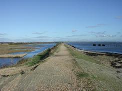
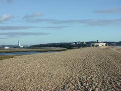
Cross the bridge and climb up onto the top of the shingle bank. Turn left and walk along the top of the spit for a couple of kilometres until Hurst Castle is reached. Walk around the right-hand, seaward side of the castle until the lighthouse is reached, and then head back towards the spit along the landward side of the castle. Walk back along the spit towards and past the bridge before heading on into Milford on Sea. This walk ends in the second car park by the sea in the town, which has some public toilets beside it.
Distances
| From | To | Distance (m) | Ascent (ft) | Descent (ft) |
|---|---|---|---|---|
| Bucklers Hard | Lymington | 8.4 | 213 | 243 |
| Lymington | Keyhaven | 6.1 | 89 | 108 |
| Keyhaven | Milford on Sea | 4.5 | 69 | 66 |
This makes a total distance of 19.0 miles, with 371 feet of ascent and 417 feet of descent.
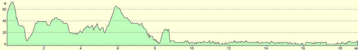
For more information on profiles, ascents and descents, see this page
Accommodation
We spent the night in the car park by the sea in Milford on Sea where this walk ended, which hopefully means that I will be able to have an early start in the morning.
Disclaimer
Please note that I take no responsibility for anything that may happen when following these directions. If you intend to follow this route, then please use the relevant maps and check the route out before you go out. As always when walking, use common sense and you should be fine.
If you find any information on any of these routes that is inaccurate, or you wish to add anything, then please email me.
All images on this site are © of the author. Any reproduction, retransmissions, or republication of all or part of any document found on this site is expressly prohibited, unless the author has explicitly granted its prior written consent to so reproduce, retransmit, or republish the material. All other rights reserved.
Although this site includes links providing convenient direct access to other Internet sites, I do not endorse, approve, certify or make warranties or representations as to the accuracy of the information on these sites.
And finally, enjoy your walking!
This walk was mentioned in the following routes:
| My walk around the coastline of Britain |
Nearby walks
| # | Title | Walk length (miles) |
|---|---|---|
| 306 | Browndown to Bursledon | 12.9 |
| 307 | Bursledon to Southampton | 9.2 |
| 308 | Southampton to Fawley | 16.4 |
|
|

|