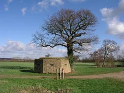
Walk #591: Maidstone to Tonbridge
 |
 |
|
General Data
| Date Walked | 08/02/2004 |
| County | Kent |
| Start Location | Maidstone West Station |
| End Location | Tonbridge Station |
| Start time | 08.45 |
| End time | 14.07 |
| Distance | 15.7 miles |
| Description | This was a fairly nice walk following the River Medway southwestwards through the lowlands of Kent. |
| Pack | Today I carried my 30-litre Karrimor HotRock rucksack, which was filled with my waterproof leggings, water bottle, trainers and a couple of spare shirts, together with the usual assortment of odds and ends. |
| Condition | Aside from a small hot-spot on the big tow of my left foot (the result of wearing my new boots for only the second time), I feel fine after this walk, and could easily have walked further if I had needed to. |
| Weather | There was a gale overnight, and unfortunately this turned out to be a headwind as I walked along. Fortunately I was sheltered from the wind for long periods, and it was only a problem at times. There was no sign of any rain as I walked, which was a dramatic difference from the overnight weather. |
| OS map | Landranger number 188 (Maidstone & The Weald, Royal Tunbridge Wells) |
 |
 |
|
 |
Map of the walk
Maps courtesy of Google Maps. Route for indicative purposes only, and may have been plotted after the walk. Please let me have comments on what you think of this new format. For a detailed table of timings for this walk, please see the table file.
Notes
I had not done a walk in the southeast for some time, so I decided that a trip to that area might be nice. After consulting one of the few maps of the southeast that I have with me in my new house in Cambridge (the rest of them still being up at my parents' house in Derbyshire), I decided on doing a walk from Maidstone. Whilst looking at the best route on the AA website, I was surprised to see that it would take me under an hour and a half to get there, so that settled the idea into a firm plan.
Once I arrived at Maidstone I pulled into the first car park that I found, which was near to the Odeon cinema. Fortunately this was also near to a railway station, so it would be easy to get back to at the end of the walk. Even better, on Sundays the car park is free to park in, whilst for the other six days of the week it costs four pounds. This little fact alone put me in a good mood, and the money saved essentially paid for my train fare back to Maidstone.
For the entire day I would be following the Medway Valley walk, which follows the river as it heads southwestwards through Kent to Tonbridge. It proved to be exceptionally easy to find the path from the car park where I had parked, as it was just around the corner from the cinema complex that dominated the area. I soon found myself passing a nice, modern pedestrian footbridge over the river, with a pretty church located on the other bank.
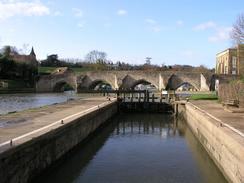
The footpath was initially very churned up, and I found that my boots and trousers were, as usual, getting very muddy. I soon left the outskirts of Maidstone behind me as I passed through a semi-derelict industrial area, with some attractive, expensive houses on the other side of the river. A railway line came to join me on the right, although this was not too noisy or bothersome, with infrequent trains travelling along it. I soon found myself at the lock and attractive multiple arched bridge at East Farleigh, a lovely spot that I would not have minded lingering at. The walk called me on, however, so I continued on along the path.
There were canoeists on the river near the bridge at Teston, and it looked as though they were enjoying themselves as they powered past me upstream. I took a much more leisurely pace, enjoying the walk much more now that the path had become less churned up and muddy underfoot. Not much happened as I passed Nettlestead Station, which was complete with rows of boats moored up, and time and mile seemed to fly by as I reached the B2162 road near Yalding. I had to follow the road for a short distance to another lock and weir, where there were some more canoeists enjoying the white water conditions downstream of the sluice gates.
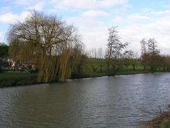
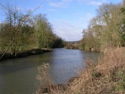
From here on the path took to the other, eastern, bank of the river as it heads southwestwards. It soon passed under the railway line, which was left far behind, and under the A228 road before reaching the lock at East Peckham. From here on the path became much more rural and far nicer, with the river seeming quite secluded in places. I enjoyed the stroll along the path, and there were only a few other walkers about to spoil the solitude.
At several places there were fallen trees across the path, victims of the recent high winds, but most of these were easy to climb over. The exception, however, as a big tree that had fallen parallel to the path. The branches were pointed towards me, and with the river on my right and a boggy area on my left I had no choice but to try and make my way through the branches. This initially meant breaking and bending a multitudinous horde of small branches that were in my way, and these were followed by larger branches that I had to climb under and over to get to the main trunk, which had broken near its base leaving large jagged wooden spikes pointing skywards.
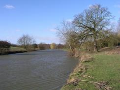
Slightly the worse for wear by the episode I continued on, passing a series of locks as the river headed westwards towards Tonbridge. The Medway is the longest river in Kent, and even here, thirty miles from the sea, it was still a wide and sprawling river. About two miles from the end of the walk I came across some lock gates that were purposefully left open to relieve floodwaters, and the river beyond here was significantly reduced in depth. This was actually quite interesting as it exposed the part of the riverbanks that you normally do not see, and proved yet again the old adage that rivers erode on the outside of bends, and deposit on the inside of them.
Eventually I reached the outskirts of Tonbridge, where I went slightly wrong and had to walk along a main road past a B&Q to gain access to the river once more. I have never been to Tonbridge before and the riverside areas of the town were quite nice, with old riverside buildings having been relatively tastefully converted into pubs and restaurants. When I reached Town Bridge, however, I had the biggest shock - on the other side of the river was the ruinous curtain wall of a castle, the keep of which was visible nearby. I had not expected Tonbridge to have a castle, and it was a remarkable nice spot.
I did not bother standing around to explore the area as I was unsure what time the next train was due, so I hurried on down to the station, where it turned out I had a thirty-minute wait. I settled down in the waiting room and read the Sunday Times, satisfied at having done a very nice and satisfying walk. For more information on the River Medway navigation, see Jim Shead's webpages.
Directions
This walk starts off at the Barker Road car park in Maidstone, which is near to the Odeon Cinema and just off the A20 road near the centre of the town. Leave the car park and turn right towards the cinema, and then turn left to walk along a short road and along a path to gain access to the western bank of the River Medway. Once at the riverbank turn right and walk along a footpath that follows the western bank of the river, initially passing a new pedestrian footbridge before slowly leaving Maidstone.
The path is part of the Medway Valley Walk, and this follows the river all the way to Tonbridge. At the B2163 road the Medway Valley Walk goes over to the southern bank; I continued on into Nettlestead along a footpath on the northern bank of the river that in places squeezes between the river and railway line for about a mile and a half until the Medway Valley Walk is rejoined immediately to the south of Wateringbury. From here, continue south along the western bank of the river. Once the B2162 road is reached turn left and follow the road southeastwards for a short distance until it crosses a bridge over a canal lock; when the bridge over the River Medway is reached son afterwards turn right past the sluice gates and start walking along the southern bank of the river.
The path continues on this bank of the river for a little under four miles until East Lock is reached, where it crosses over to the northern bank. This can then be followed westwards into Tonbridge. On the outskirts of the town a track leads off through a recreation ground to Swanmead Way and the A26; do not take this road but continue on along the footpath as it skirts slightly away from the river.
At the bridge that carries the A26 over the river the path crosses to the southern bank, and this can be followed all the way to Town Bridge and the High Street. At this bridge turn left and walk down the High Street. The road climbs up to a bridge over a railway line; this walk ends at Tonbridge Station, the entrance to which is on the right at the top of the bridge.
Distances
| From | To | Distance (m) | Ascent (ft) | Descent (ft) |
|---|---|---|---|---|
| Maidstone | Wateringbury | 5.4 | 289 | 285 |
| Wateringbury | East Peckham | 3.7 | 52 | 39 |
| East Peckham | Tonbridge | 6.6 | 49 | 7 |
This makes a total distance of 15.7 miles, with 390 feet of ascent and 331 feet of descent.
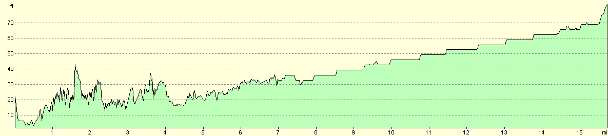
For more information on profiles, ascents and descents, see this page
Transport
There are regular (hourly on Sundays) train services between Tonbridge and Maidstone, calling at all of the station en route if you want to do a shorter walk. The ticket cost me £4.90 for a single journey.
Disclaimer
Please note that I take no responsibility for anything that may happen when following these directions. If you intend to follow this route, then please use the relevant maps and check the route out before you go out. As always when walking, use common sense and you should be fine.
If you find any information on any of these routes that is inaccurate, or you wish to add anything, then please email me.
All images on this site are © of the author. Any reproduction, retransmissions, or republication of all or part of any document found on this site is expressly prohibited, unless the author has explicitly granted its prior written consent to so reproduce, retransmit, or republish the material. All other rights reserved.
Although this site includes links providing convenient direct access to other Internet sites, I do not endorse, approve, certify or make warranties or representations as to the accuracy of the information on these sites.
And finally, enjoy your walking!
Nearby walks
| # | Title | Walk length (miles) |
|---|---|---|
| 645 | Tonbridge to Edenbridge | 17.1 |
| 679 | Otford to Strood | 19.8 |
| 680 | Strood to Hollingbourne | 21.8 |
|
|

|