Walk #592: Boston to Sleaford
 |
 |
|
General Data
| Date Walked | 14/02/2004 |
| County | Lincolnshire |
| Start Location | Boston Station |
| End Location | Sleaford Station |
| Start time | 09.15 |
| End time | 15.39 |
| Distance | 19.2 miles |
| Description | This was a quite straightforward and fairly uninteresting walk, with scarcely any hills to be climbed anywhere on the route. This is probably to be expected in Lincolnshire. |
| Pack | Today I carried my 30-litre Karrimor HotRock rucksack, which was filled with my waterproof leggings, water bottle, trainers and a couple of spare shirts, together with the usual assortment of odds and ends. |
| Condition | I feel absolutely fine after this walk, and I could have walked further if I had needed to. My feet ache slightly, which is to be expected as I am wearing relatively new boots, but fortunately there are no signs of any blisters. |
| Weather | The weather today was quite miserable - when I reached Boston to start the walk it was raining a light yet persistent rain, and although this stopped for a couple of hours it restarted by the time I reached Asgarby. It was not a cold day, however, and there was not much wind to chill me, so it could have been much worse. |
| OS map | Landranger number 131 (Boston & Spalding) and Landranger number 130 (Grantham, Sleaford & Bourne) |
 |
 |
|
Map of the walk
Maps courtesy of Google Maps. Route for indicative purposes only, and may have been plotted after the walk. Please let me have comments on what you think of this new format. For a detailed table of timings for this walk, please see the table file.
Notes
For a couple of years now I have been wanting to connect Boston westwards to my Land's End to John O'Groats walk at Bingham (near Nottingham). My coastal walk prevented me from doing this, but now that is out of the way I decided it would be a good idea to get the walk out of the way. I had planned the walk in three stages, the longest of which is to be the stretch from Boston westwards to Sleaford, and it was this one that I wanted to do first.
It was raining as I reached Sleaford station, and I was tempted to call the walk off as I really did not fancy getting soaked. The train soon arrived, however, and I found myself on the twenty-minute trip to Boston. On the way I realised that I had left my Walkman behind in the car, so I knew that I would have to keep myself entertained for the day. This normally would not be difficult, butt the terrain promised to be flat and potentially boring, so I was slightly concerned that I would get bored as I walked.
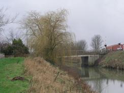
The initial stretch was following the A52 as it headed southwestwards out of Boston, until I reached the bridge over the South Forty Foot Drain. I could have walked along the A1121 road that follows the northern side of the drain beside the railway line, but instead I opted to walk the footpath that runs along the southern bank. For the first five kilometres the drain runs in a dead-straight westerly direction, passing Hubbert's Bridge before eventually reaching a curve to the left. As the rain was quite heavy at this time I just put my head down and walked on, and I was surprised to find that the walk went quite quickly.
Eventually the bank reaches the A17(T) and Swineshead Bridge, and it was here that I was faced with a quandary. The South Forty Foot Drain curves to head southwestwards, away from the direction that I wanted to head, so I was forced away from the drain. Unfortunately there was no easy alternative except for walking along the A17(T) towards Heckington, which for obvious reasons I was reluctant to do. In the end I decide to walk through a farmyard and along a track that follows the northern side of the drain to a sluice, passing a frightening bird-scarer on the way, a strange green pipe powered by bottled gas.
Once I reached the pumping house at the bend in the river the footpath followed the river, so I was forced to walk westwards across the fields beside the railway line. There was no footpath here so technically I was trespassing, and in two places I had to skirt onto the wide median strip of railway line between track and field to cross field drains. I did not like having to trespass like this, but I was faced with little choice. The ground underfoot was very wet, and whenever I trod onto the ground my feet formed inch-thick clods of mud underneath them, weighing my feet down and making progress harder. To avoid this I tried walking on the unploughed strip at the edge of the field beside the fence, but in many places this strip was too narrow to be easily able to do it.
Eventually, and with some relief, I reached a little level-crossing that headed across the railway line towards a farm. This allowed me to make easier progress as I could follow a track that heads westwards across Great Hale Fen, before joining a road that took me into Great Hale. After stopping to have a quick look at Great Hale church I walked down to the station, which has a prominent sail-less windmill beside it. The level crossing was shut when I reached the station and I was tempted to jump on the train back to Sleaford, cutting the walk short, but it was just a fleeting thought and as I was still feeling fine I decided to walk on.
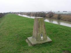
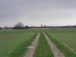
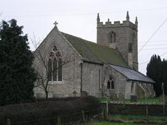
I probably did not see the best side of Sleaford and I did not really find it particularly pretty, although it was certainly not ugly. On my way out of the village along the B1394 road I passed another windmill - this time just a brick pillar, with no woodwork at all left on it, before taking a track that headed westwards past Lodge Farm and a trig point (nearly hidden in a field with a very inquisitive horse), before reaching a road. I then followed this road northwards to the A17(T) and the beautiful village church at Asgarby, which has a tall and slender stone tower that was a prominent landmark for miles around.
A footpath across fields took me the two kilometres to the church at Kirkby la Thorpe, and whilst this is not as spectacular as its neighbour at Asgarby it is still a lovely little church. It was after this that I went wrong; the road heads south, crossing the A17(T) via a bridge, but instead of immediately turning to the right once across the bridge I continued straight on - I was too bust daydreaming to realise that I had taken the wrong road, and I only realised as I approached a level crossing and I awoke from my daydreaming.
Annoyed with myself I headed back up to the bridge and then started the walk back towards Sleaford. The rest of the walk was along roads, heading west and passing under a railway bridge to reach the outskirts of the town. Before I reached the centre I passed a strange tiled mosaic, which closer examination showed to be a tribute to the Roman settlements in the town. I passed the beautiful carved stone cross in the centre of the town before eventually reaching the railway station and my car after a surprisingly enjoyable walk.
Directions
This walk starts off at Boston station. Leave the station by the eastern entrance and then turn right for a few yards down Station Approach until it ends at a T-junction with the A52 Sleaford Road. Turn right and follows the A52 as it immediately crosses the railway line on a level crossing before curving to head southwestwards pout of the town. At a mini-roundabout by a level crossing turn slightly to the left to cross the level crossing and the bridge over the South Forty Foot Drain. Once on the southern side of the drain turn right to join a footpath that run along the southern bank of the drain.
Stay on this footpath as it heads westwards for about five and a half miles, passing Hubbert's Bridge on the way. When the A17(T) is reached at Swineshead Bridge turn right to cross the bridge and continue on up the A17(T) for a few yards. When a farm is reached on the left turn left to follow a track that heads through the farmyard before heading southwestwards across a field for a short distance to meet the railway line. The track then follows the railway line westwards for a kilometre until it reaches a pump house beside the drain.
From the pump house I followed the northern side of the railway line as it headed westwards; there is not footpath so I trespassed across a few fields. It should be noted that in two places there are drains that needed to be crossed, and the easiest way of doing this was to go up onto the median strip between railway line and field, which was also trespassing on railway property. Eventually another track was reached by an informal planked level crossing; join this track and follow it as it heads westwards across Great Hale Fen for a little under a mile before joining the surfaced Great Hale Drove.
Follow the road westwards passing under some power lines and over the railway line before reaching Great Hale. On the outskirts of the village turn right down Grove Street and follow it until it reaches the B1394 Hale Road near the church. Turn right and follow the B1394 as it heads northwards past the railway station to a crossroads in the centre of Heckington. Here turn left along the B1394 High Street, which heads westwards through the village. A little over a kilometre later the road passes the stump of an old windmill on the right, and shortly afterwards take a track that leads off to the left.
This track crosses the railway line and then heads westwards to head across fields towards Lodge Farm. The track passes through Lodge Farm before ending at a T-junction with Burton Road. Turn right down this road and follow it northwards for a little under a mile until it reaches the A17(T). Here a footpath is marked on the map heading northwards to Asgarby but I could find no trace of the path on the ground, so I turned left to walk along the A17(T) for a short distance before turning to the right up a road that leads northwards to Asgarby Church. At the church turn left to walk through the graveyard past the church; at the far side a footpath heads off to the left, heading across fields for a couple of kilometres towards the church in Kirkby la Thorpe.
When the footpath ends at Church Lane near to Kirkby la Thorpe church turn left to head southwards along the lane towards the A17(T). Cross the road using the bridge, and once on the other side of the bridge turn right to head westwards along Boston Road. This road eventually enters the town after passing under a railway bridge, and ends at a t-junction with the B1517 South Gate near to the town cross. Turn left for a few yards along the B1517 until just before it reaches a level crossing, and then turn right down Station Road to Sleaford Station, where this walk ends.
Distances
| From | To | Distance (m) | Ascent (ft) | Descent (ft) |
|---|---|---|---|---|
| Boston Station | Swineshead Bridge | 6.8 | 0 | 0 |
| Swineshead Bridge | Heckington | 5.3 | 39 | 7 |
| Heckington | Sleaford Station | 7.1 | 95 | 85 |
This makes a total distance of 19.2 miles, with 134 feet of ascent and 92 feet of descent.
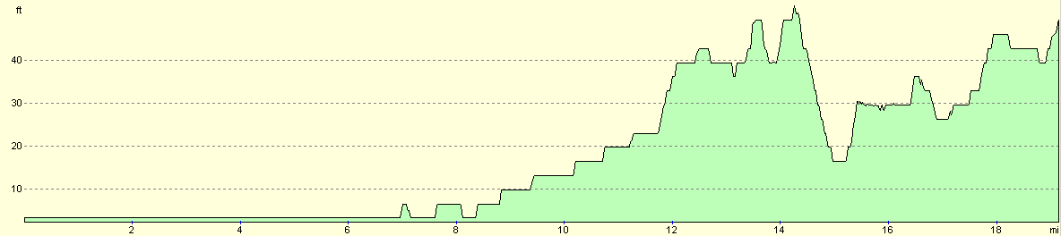
For more information on profiles, ascents and descents, see this page
Transport
There are regular railway services between Sleaford and Boston, costing a three pounds seventy pence for a single ticket. These services are less frequent on a Sunday, however. You can park at Sleaford station for a pound all day, which is not a bad price for station parking in a town. If you wish to cut this walk short there are some intermediate stations, most notably the one at Heckington.
Disclaimer
Please note that I take no responsibility for anything that may happen when following these directions. If you intend to follow this route, then please use the relevant maps and check the route out before you go out. As always when walking, use common sense and you should be fine.
If you find any information on any of these routes that is inaccurate, or you wish to add anything, then please email me.
All images on this site are © of the author. Any reproduction, retransmissions, or republication of all or part of any document found on this site is expressly prohibited, unless the author has explicitly granted its prior written consent to so reproduce, retransmit, or republish the material. All other rights reserved.
Although this site includes links providing convenient direct access to other Internet sites, I do not endorse, approve, certify or make warranties or representations as to the accuracy of the information on these sites.
And finally, enjoy your walking!
Nearby walks
| # | Title | Walk length (miles) |
|---|---|---|
| 181 | Boston to Fosdyke Bridge | 11.6 |
| 249 | Gibraltar Point to Boston | 24.7 |
| 250 | Boston Station to Holbeach St Matthew | 20.7 |
|
|

|