Walk #532: Wick to Lybster
 |
 |
|
General Data
| Date Walked | 19/08/2003 |
| County | Highlands |
| Start Location | Wick |
| End Location | Lybster |
| Start time | 09.54 |
| End time | 16.23 |
| Distance | 17.2 miles |
| Description | This was a nice walk southwestwards along the coast from Wick. |
| Pack | Today I carried my 30-litre Karrimor HotRock rucksack, which was filled with my packed lunch, waterproof leggings, water bottle and a couple of spare shirts, together with the usual assortment of odds and ends. |
| Condition | I did not have many problems on this walk; thankfully my left knee gave me no troubles, and the only thing that I can complain about is the fact that the underside of my feet ached by the time that I finished the walk. |
| Weather | The main feature of today's weather was the wind, which was gusting strongly at times. Before I set off in the morning there was some heavy rain, but this had stopped by the time that I eventually set off. There was one heavy shower at about two in the afternoon, but this did not last long and the wind helped me dry off fairly quickly. It was also a relatively cold day, and the wind made this worse, so I was glad that I had my coat on. |
| OS map | Landranger number 12 (Thurso & Wick, John O'Groats) and Landranger number 11 (Thurso & Dunbeath) |
 |
 |
|
 |
 |
|
Map of the walk
Maps courtesy of Google Maps. Route for indicative purposes only, and may have been plotted after the walk. Please let me have comments on what you think of this new format. For a detailed table of timings for this walk, please see the table file.
 |
Notes
I must admit that I was not very impressed with Wick, and if it came to a choice between Wick and Thurso to live then I would definitely prefer Thurso. This is a shame as Wick has some lovely touches - one building next the harbour has a large barometer on it, and some of the buildings are very nice. But the town seemed to me to be in decline, which was a shame. I had to set off a little later than I wanted this morning as I had to wait to do a telephone interview with the local paper, although this was not a great loss as it meant that I missed the worst of the rain, which had been heavy for much of the morning. This meant that the weather matched my mood quite well, as I was definitely not looking forward to the day's walk.
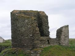
The Castle of Old Wick was not the most impressive castle that I have seen in the last few days, but it was nice to look around nonetheless. You can walk around the ruins, and I was amazed by the thickness of the stone walls of the fortress. It was probably built by the earl of Caithness, Harald Madddadon as his chief seat on the mainland. In the 14th Century the castle was held by Sir Reginald de Cheyne, who was a supporter of King Edward I. Sailors know the castle as 'The Old Man of Wick', and was an important navigational aid to ships trying to find Wick Harbour.
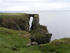
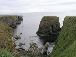
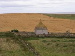
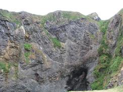
The walk along the coast south of the castle took me past several impressive inlets in the cliffs, including the Brig o'Trams, a 300-foot high natural bridge linking he mainland to a stack. I walked over this bridge thinking it was a narrow promontory, and only when I got a short distance away could I see what I had walked over! By the time that I neared Sarclet I was fed up with wading through the heater, so I chose to walk along roads as far as possible. This decision took me to the Mains of Ulbster, where some farmers herded a flock of sheep past me as I stood on the verge. At the Mains of Ulbster there is an intriguing little building in what looks like a private graveyard. On the map there is a path shown heading southwest from the farm to the A99(T) over the Hill of Ulbster, but I could not find this on the ground and ended up making my own way across the ground, which was not much of a hardship as the scenery was nice.
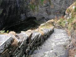
I had intended the highlight of the day to be the steps of Whaligoe, which people had recommended to me. There are over 300 steep steps that leads from the top of the cliffs down to the tiny haven at the bottom, zigzagging down the sheer cliff face. It is an impressive sight, but unfortunately just as I arrived at the top of them it started to rain. I made my way carefully down, and once at the bottom I waited for the rain to stop so that I could take some photos. I sat down on a little stone jutting out from the base of the steps and pressed myself into the face of the steps (which shielded me from the worst of the rain) as I ate my sandwiches. After fifteen minutes the rain ceased, and I could start to look around the Haven. In the 19th Century the steps were used by fishermen's wives to carry heavy baskets of fish up to the top of the cliffs, and then on to Wick for sale. It was hard enough going up the steps with a rucksack, yet alone with a heavy load of fish! They certainly made people hard in those days.
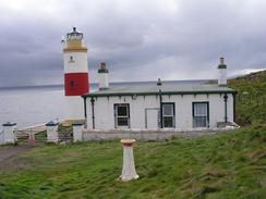
The majority of the rest of the walk was along the A99(T), except for the fact that I made a little diversion down to see the lighthouse at Clyth Ness, which is perched at the top of 100 foot cliffs. At West Clyth Farm I diverted along a track that took me to a road that led westwards into Lybster, where I found Sam waiting for me on the wide main street of the is model village, founded by Sir John Sinclair in the early 19th Century. I had intended to walk on towards Latheron, but Sam was lonely and the undersides of my feet were hurting, so I decided to end the day early. This was a good decision, and it allowed me to use the computer at the campsite to get some work done in the late afternoon.
As of today I have done over 4,010 miles of walking this year, which seems to me to be an almost astronomical figure. I do not have far to go now to the end of the walk - a mere matter of 500 miles (in a perverse way this small mileage seems much larger than the 5,500 I have already completed). This mileage is likely to increase, as I am about a week ahead of schedule to reach Edinburgh by the 27th of September, and I may extend the walk by going around some of the estuaries (e.g. the Dornoch Firth and the Firth of Tay) rather than taking the first bridges over them. Doing these would be valid as they are river estuaries, and they may well pad out the walk nicely. I have not planned them yet, however, and so I may make the decision about whether to go walk around them or not once I got to each one.
Directions
This walk starts off on the northern side of the Wick Harbour Bridge in Wick. Cross the bridge onto the southern side of the Wick River, and then turn left down Martha Terrace for a few yards and then turn right down Harbour Terrace, which leads uphill. At the top of the hill turn left down Smith Terrace, which in turn becomes Bexley Terrace. At the end of the road join a footpath that head along the top of the cliffs towards South Head. Just before the head is reached the path joins a road, and this heads around the headland to head southwestwards before it ends at a car park.
At the car park a footpath leads on across a field towards the Castle of Old Wick. At the castle a rough path follows the edge of the cliffs southwards as it passes a series of inlets and islands for about four kilometres towards Broad Geo. Here I headed inland slightly to a little cottage, from where a track head southwestwards and becomes a road. Follow this road southwestward past Corbiegoe, and when it ends at a t-junction turn right up another road.
When this road curves slightly to the right turn left down another road, which heads southwards for a couple of kilometres to the west of Loch Sarclet until it ends at the farm at Mains of Ulbster, where the road becomes a track. Follow the track through the farm, and then turn to the right to climb westwards along the southern flank of the Hill of Ulbster. Although there is a path marked on the map over the hill I could not find this on the ground and so I made my own way southwestwards over the hill, eventually emerging onto the A99(T) by a cottage called 'The Fields'.
Turn left to head south down the A99(T) through Ulbster. After about a mile Whaligoe is reached; if you want to visit Whaligoe haven then turn left immediately after a road junction on the right down an access road past a row of cottages to where there is a house. Skirt to the right of the house and turn the corner to the top of the more than three hundred steps that lead down to the Haven.
Once you have visited the Haven return to the A99(T) and turn left, to follow it as it winds southwestwards through Bruan and Blackness. After a few miles West Clyth Farm is reached; a hundred yards past the farm turn left down a track that heads southwards past a small patch of woodland on the left. The track passes a steel fabrication company and goes through a couple of gates. After the second gate another track leads off to the right.
Take this track and follow it westwards for a few hundred yards through a farm, where it joins a road near Hillhead House. Join this road and follow it westwards for about a kilometre until it ends at a crossroads In Lybester, and then turn left and head southwards down another road. This walk ends a couple of hundred yards down this road, at the junction with another road that leads off to the right towards the harbour.
Distances
| From | To | Distance (m) | Ascent (ft) | Descent (ft) |
|---|---|---|---|---|
| Wick | Whaligoe Haven | 10.0 | 1385 | 1388 |
| Whaligoe Haven | Lybster | 7.2 | 692 | 502 |
This makes a total distance of 17.2 miles, with 2077 feet of ascent and 1890 feet of descent.
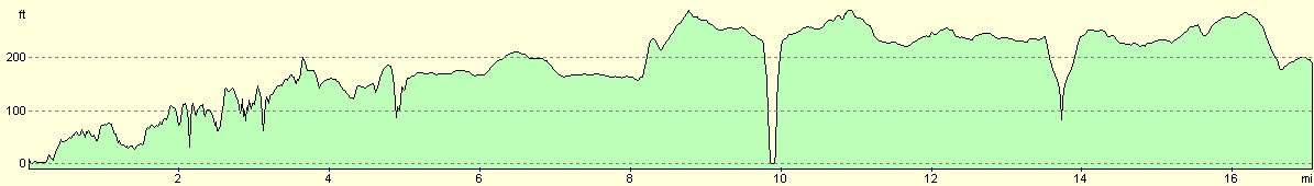
For more information on profiles, ascents and descents, see this page
Accommodation
We stayed at the Inver Caravan Park, Houstry Road, Dunbeath, Caithness KW6 6EH. They can be contacted on (01593) 731441, or by email at rhonagwillim@aol.com, or on the web at www.holidayincaithness.com. This small site was very nice with clean facilities and the owner was very friendly and welcoming. the site cost us eleven pounds for the night, plus one pound for each load of washing, which got dried quickly in the fierce winds.
Disclaimer
Please note that I take no responsibility for anything that may happen when following these directions. If you intend to follow this route, then please use the relevant maps and check the route out before you go out. As always when walking, use common sense and you should be fine.
If you find any information on any of these routes that is inaccurate, or you wish to add anything, then please email me.
All images on this site are © of the author. Any reproduction, retransmissions, or republication of all or part of any document found on this site is expressly prohibited, unless the author has explicitly granted its prior written consent to so reproduce, retransmit, or republish the material. All other rights reserved.
Although this site includes links providing convenient direct access to other Internet sites, I do not endorse, approve, certify or make warranties or representations as to the accuracy of the information on these sites.
And finally, enjoy your walking!
This walk was mentioned in the following routes:
| My walk around the coastline of Britain |
Nearby walks
| # | Title | Walk length (miles) |
|---|---|---|
| 531 | Duncansby Head to Wick | 22.4 |
|
|

|