Walk #531: Duncansby Head to Wick
 |
 |
|
General Data
| Date Walked | 18/08/2003 |
| County | Highlands |
| Start Location | Duncansby Head |
| End Location | Wick |
| Start time | 09.02 |
| End time | 18.03 |
| Distance | 22.4 miles |
| Description | This was an absolutely superb walk along the cliffs south from Duncansby Head to Wick, passing several ruined castles on the way. |
| Pack | Today I carried my 30-litre Karrimor HotRock rucksack, which was filled with my packed lunch, waterproof leggings, water bottle and a couple of spare shirts, together with the usual assortment of odds and ends. |
| Condition | My left knee ached a little at times today, but this was not continuous or too severe. At times my left ankle also ached, but again this was not enough to worry me overly. |
| Weather | The most notable feature of today's weather was the wind, which had strong gusts at times. The day started off quite grey, but the sun soon came out. Towards the end of the day there was some drizzle, but fortunately this did not become rain until after the walk finished. |
| OS map | Landranger number 12 (Thurso & Wick, John O'Groats) |
 |
 |
|
 |
 |
|
Map of the walk
Maps courtesy of Google Maps. Route for indicative purposes only, and may have been plotted after the walk. Please let me have comments on what you think of this new format. For a detailed table of timings for this walk, please see the table file.
 |
 |
|
 |
 |
|
Notes
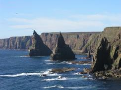
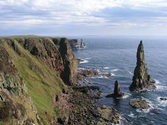
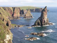
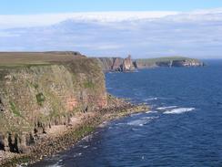
The first couple of miles south from the lighthouse at Duncansby Head were absolutely superb, with some great scenery. It was a brilliant way to restart my walk down the east coast (having turned the corner onto the south coast early last December). The highlight of the early pat of the walk were the Duncansby Stacks, some massive stacks sticking out of the sea half a mile to the south of the lighthouse. There were literally hundreds of seabirds flying around the stacks, and I could not help but take many photographs of the stacks. The cliffs in the area are split by many narrow and deep chasms, and I had to be careful in places not to fall into them.
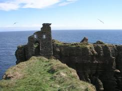
Once I reached the northern side of Freswick Bay near Skirza Head I decided to follow the road westwards for a mile before heading south to the beach. This little road diversion allowed me to get some speed up, and I do not think that I really missed anything by avoiding that little stretch of coast. I walked south under the cliffs from the beach past Freswick House, and then climbed up onto the top of the cliffs and walked to Ness Head, from where there was a great view northwards over Freswick Bay. A little further down the coast I came across the ruins of a castle at Castle Geo. There was very little left of this castle, but what there was - mainly the area around the entrance - was very spectacular. I went up so that I could have a closer view, but there was a sheer drop on either side of the approach to the gateway, and just before it was a six-foot drop that I would have to climb down and up (perhaps where there used to be a drawbridge). I very much chickened out of doing this, and made do with just looking at it from the outside.
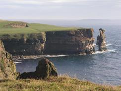
The cliffs south from Castle Geo were lower than those that I had passed earlier in the day, but they were still characterised by deep chasms. At Nybster I passed three curious and eccentric cairns, bedecked by statuettes, which were apparently built in the 19th Century by a gentleman called John Nicolson. These seemed very out of place, but certainly were points of interest. Further south I passed the ruins of Keiss Castle, which were very impressive and sited next to the equally impressive Keiss House. I met Sam for lunch a little further on at the nice Keiss Harbour, which looked very nice in the sunshine. Sam had made me some ham salad sandwiches, and I wolfed these down before heading out one more into the wind.
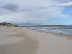
The beach beside Sinclair's Bay is the longest in the whole of Caithness, and although it started off stony it soon became a nice strip of sand, which was narrow due to the high tide. The northern end of the beach was dominated by lines of tank traps, leftovers from the Second World War that still looked in reasonably good condition. In places the lines were still intact, but on others the sea had thrown them all over the beach. I find it quite strange that having seen very few (if any) Second World War defences on the northwestern or northern coast of Scotland; I walk a short distance down the east coast and find plenty. These lines ended when the sand dunes began, and the walk along the beach was very enjoyable.
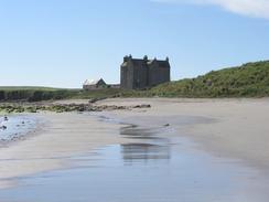
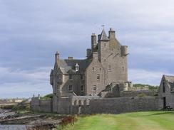
Just before I reached Ackergill Tower I met a gent who was rebuilding a thick stone wall the marked the boundaries of the tower's grounds. Part of the wall had been swept away by the sea, and so he was rebuilding it as it used to be. I chatted to him for a while, as dry stone walling is an art that you do not see being done much nowadays, although the wall was of a different style and far thicker than those of my native Derbyshire. The tower itself is exceedingly grand (it is more like a castle than a simple tower). It was built in the fifteenth or sixteenth century and is the oldest inhabited house in Scotland.
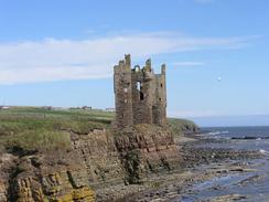
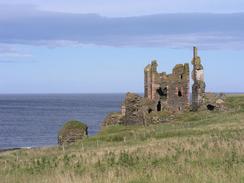
The walk eastwards along the cliffs towards Noss Head was quite enjoyable, with a sweeping vista available over Sinclair's Bay. Just before I reached the lighthouse at Noss Head I came across one of the strangest sights of the trip so far - what are virtually semi-detached castles! Castle Sinclair is quite ruined with only a few walls left, but next door to it was the much more complete Castle Girnigoe. The two castles are so close together that they look as if they are all part of one building, and I wonder why they were built in such a manner. Because the sun was quite low in the sky I could not get a decent photo of them, and I did not bother to explore the ruins further. The lighthouse at Noss Head looked far better than the one at Duncansby Head, looking much more like the archetypal lighthouse. The rest of the walk was simply a case of following the cliffs southwards into Staxigoe, and heading into Wick along roads and footpath from there.
Sam was waiting for me by the first bridge over the river in Wick, which seems a reasonably nice town. At eight thirty we went out to the Wetherspoons pub in the town for a quick drink, which is a new (and very clean) pub. Unfortunately they did not have any real ales on tap. We were surprised by how quiet the town was - there was hardly anyone on the streets, although it did not stop a couple of giggling girls from knocking on Mervan's door at two in the morning! Tomorrow I am going to be heading further southwest down the coast towards Latheron; how far I get will depend on the weather and the going underfoot.
 |
Directions
This walk starts off in the car park by the lighthouse at Duncansby Head. Leave the car park and head along an obvious path that passes a trig point before descending along the top of the cliffs past The Knee. The path then ascends past Thirle Door and passes the Stacks of Duncansby before reaching the top of the Hill of Crogodale. From here the path becomes increasingly indistinct and eventually disappears, and I followed the coast southwards past the two dramatic inlets of Fast Geo and Wife Geo, which in bad weather could be easy to fall into. Follow the coast southwards for a little over a kilometre until a track is reached. Join this track and follow it westwards to a farm, and then join a road that heads westwards along the road for a little under a mile.
When the road curves to the right just before a church, turn let down a track that leads to the northern end of the beach at Freswick Bay. Join the beach and follow it southwards, passing under Freswick House and passing around a small headland (at high tide you may have to join the clifftop at Freswick House) and scrambling up the cliffs to reach the clifftop.
Follow the top of the cliff southeastwards to Ness Head, and then head south along the coast past Castle Geo, Black Score and Samuel's Geo, before reaching a little car park beside the coast in Nybster, which is guarded by a strange cairn. Continue on down the coast, passing another large cairn, before reaching the dramatic ruins of Keiss Castle. Just south of the castle a path leads down towards the foreshore, and onwards to Keiss Harbour.
At the harbour take some steps that lead up to the road at the top of the hill. Turn left and follow the road as it heads towards the A99 road, but after a few yards there is a gravel path that heads off to the left downhill. Follow this path as it heads southwestwards before it ends at a track, and then follow the track as it follows the foreshore southwards to a car park at the Rough of Stain. Here join the beach, and follow this southward for a few miles until it ends near the Ackergill Tower.
When the beach ends and the foreshore becomes rocky, join a little path that runs on the seaward side of the wall around the grounds of the tower. Pass under the tower, and at a cottage join a track for a few yards. When the track curves to the right continue straight on down a path that leads across a field and leads to a gate into a children's playground. Cross this and cross over a road and head along a track across a field to the farm at Shorelands.
At Shorelands turn left to head northwards along a track back to the top of the cliffs. Turn right to head eastwards along the top of the cliffs, passing the ruins of Castle Sinclair and Castle Girnigoe and eventually reaching Noss Head Lighthouse. At the lighthouse turn right and follow the edge of the cliffs southwards for a couple of kilometres to the farm at Field. Go through the farm and leave it southwards along a track that becomes a road in Staxigoe.
Follow this road through the village as it curves to the left past a road junction, and heads through Papigoe and past Broad Haven. When the road curves to the right in Broadhaven turn left down a minor road that heads along the southern side of Broad Haven to North Head, where a path heads westwards along the northern edge of Wick Bay. Pass a war memorial and above the North River pier join The Shore, which leads westwards to Wick Harbour Bridge, where this walk ends.
Distances
| From | To | Distance (m) | Ascent (ft) | Descent (ft) |
|---|---|---|---|---|
| Duncansby Head | Freswick House | 5.5 | 1165 | 1316 |
| Freswick House | Keiss Harbour | 5.4 | 784 | 771 |
| Keiss Harbour | Noss Head | 7.3 | 640 | 528 |
| Noss Head | Wick | 4.2 | 285 | 407 |
This makes a total distance of 22.4 miles, with 2874 feet of ascent and 3022 feet of descent.
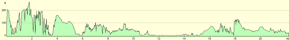
For more information on profiles, ascents and descents, see this page
Accommodation
We parked Mervan in a little car park on Market Street in Wick, right next to Wick Harbour Bridge. This was very handy for some of the pubs in the town, had a lovely view over the river and was reasonably quiet.
Disclaimer
Please note that I take no responsibility for anything that may happen when following these directions. If you intend to follow this route, then please use the relevant maps and check the route out before you go out. As always when walking, use common sense and you should be fine.
If you find any information on any of these routes that is inaccurate, or you wish to add anything, then please email me.
All images on this site are © of the author. Any reproduction, retransmissions, or republication of all or part of any document found on this site is expressly prohibited, unless the author has explicitly granted its prior written consent to so reproduce, retransmit, or republish the material. All other rights reserved.
Although this site includes links providing convenient direct access to other Internet sites, I do not endorse, approve, certify or make warranties or representations as to the accuracy of the information on these sites.
And finally, enjoy your walking!
This walk was mentioned in the following routes:
| My walk around the coastline of Britain |
Nearby walks
| # | Title | Walk length (miles) |
|---|---|---|
| 530 | Dunnet Head to Duncansby Head via John O'Groats | 19.7 |
|
|

|