Walk #530: Dunnet Head to Duncansby Head via John O'Groats
 |
 |
|
General Data
| Date Walked | 17/08/2003 |
| County | Highlands |
| Start Location | Dunnet Head |
| End Location | Duncansby Head |
| Start time | 09.05 |
| End time | 17.51 |
| Distance | 19.7 miles |
| Description | This was quite a nice walk, mostly along the cliffs on moorland or fields, but also a little bit of main road walking. |
| Pack | Today I carried my 30-litre Karrimor HotRock rucksack, which was filled with my packed lunch, waterproof leggings, water bottle and a couple of spare shirts, together with the usual assortment of odds and ends. |
| Condition | I feel absolutely fine after this walk, and have no significant problems to report. The underside of my feet ached slightly when I started walking on the roads, but this eased once I had changed into my boots. |
| Weather | The forecast for today was for rain in the afternoon, and indeed the morning did dawn dry, but with a lot of cloud and a strong, gusting wind. However instead of worsening the weather soon improved, and he day ended up mostly sunny if hazy, although the strong wind was still present. |
| OS map | Landranger number 12 (Thurso & Wick, John O'Groats) |
 |
 |
|
 |
 |
|
Map of the walk
Maps courtesy of Google Maps. Route for indicative purposes only, and may have been plotted after the walk. Please let me have comments on what you think of this new format. For a detailed table of timings for this walk, please see the table file.
 |
Notes
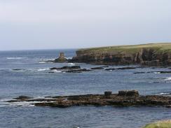
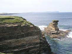
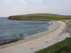
I woke up to a far cloudier day than I had gone to sleep to, with Hoy on the Orkneys barely visible through the general haze. The forecast was for rain later on in the day, and so I was keen to have an earlier start that I had recently. Sam walked with me to the little trig point above the lighthouse, and I then walked alone south along the beautiful cliffs to the B855 road. I then did a combination of road and clifftop walking eastwards along the coast, eventually passing the Castle of Mey, until recently the Queen Mother's residence. Here I got attacked by a large swarm of large black flies that got in my nose and my ears. I tried twirling my hat above my head to swat them away, but the arms of my coat were black with them. It was incredibly unpleasant, and I could not speed up too much as he ground underfoot was rough and did not permit it. I had a little relief from them at St John's Point, but by the time that I reached Scotland's Haven they were back, and I decided to divert to the road so try to get away from them.
Fortunately this worked, and although there were some flies in the hedges they were nowhere near as bad as they had been on the moorland. I met Sam at the jetty at Gills Bay, which is a ferry port over to Orkney. I assume that this is a relatively new port, as the ferry service is not marked on my Ordnance Survey map. Sam made me some lovely sandwiches, but I did not want to wait around, as Sam wanted to get off to have a look around the Castle of Mey.
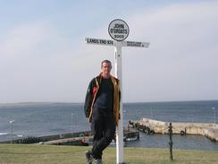
I had expected finally reaching John O'Groats to be a very emotional moment, but it really did not turn out to be so. Although reaching the Last House meant that I had finished my sectional Land's End to John O'Groats walk, four years after I started it, that walk feels like a different lifetime and a different task. With over five hundred miles left to walk on my coastal walk the last thing I need is a sense of closure, so the feeling of satisfaction at finishing my sectional Land's End to John O'Groats walk shall have to wait until after this trip is over.
As well as finishing my sectional Land's End to John O'Groats walk, today I also finished my continuous Land's End to John O'Groats walk around the western coast. This was a 3,423.4-mile walk, over six months, and must be one of the longest LE-JOG walks that you can possibly do without taking a ferry across to Ireland and walking around that island as well (which someone has done). In a strange way I have got a bigger sense of satisfaction from having completed this walk, a small part of my coastal walk, than I do from having completed the sectional walk, which has been a much longer-term operation.
Despite all this, I was quite happy to reach John O'Groats. I have never been there before, and I was quite keen to have an exploration. Sam met me there after a flying visit to the Castle of Mey, and we went of a quick look around. John O'Groats is owned by the same company who own Land's End, and the feel of the places are quite similar. John O'Groats, however, is nicer in a way, with a harbour and lower cliffs than Land's End. When I was at Land's End I had a photograph taken of me at the famous signpost, and I was hoping to have the same thing done here, but unfortunately the stall was shut for the day. This was disappointing, but even worse was the fact that the Groats Inn was shut, even on a Sunday with hundreds of people milling about! I had dreamt of going into the pub to have a pint to celebrate, so after a quick look around we went back to Mervan. I found it hard to believe that the two features that I wanted to use were shut, even on a summers Sunday, when they had been open on a wet winters weekday at Land's End!
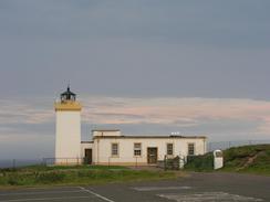
As the pub was shut I really did not want to stop at John O'Groats, so I decided to walk on to Duncansby Head, the real northeastern point of mainland Britain. The walk to the lighthouse was exceedingly pleasant, with a good path leading to the Ness of Duncansby and vague tracks leading on around the cliffs to the lighthouse. Near the lighthouse there is a massive slit in the ground that is a blowhole, a dramatic feature that is fortunately fenced off!
The views from the car park at Duncansby Head lighthouse this evening were superb, even with the haze, and as the sun went down in the west the clouds glowed a beautiful orange colour. I could just make out Dunnet Head where I started today's walk, to the north was the Island of Stroma and to the east were the twin lighthouses on the Skerries. It was a truly great way to finish the north coast of Britain, and a superb place to celebrate having reached John O'Groats, which I did with a couple of glasses of whisky.
Directions
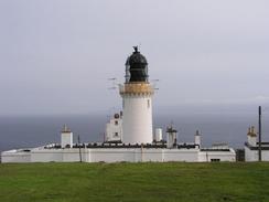
This walk starts off at the car park by the lighthouse at Dunnet Head. Leave the car park and climb up an obvious path to an observation point beside a trig point. From here descend downhill eastwards to the top of the cliffs, and then turn right to follow the edge of the cliffs southwards for a couple of miles past Sow's Geo and Meikle Score. Eventually fields replace the moorland and a cottage is reached near Sinigeo, so climb some fences and join the A855 road at a sharp bend. Walk south along the B855 road for a little under a kilometre until the road turns sharply to the right in Brough.
At the end turn left down a minor road that heads eastwards for a couple of kilometres to Ham. At a bend in the road beside Sir John's Castle turn left and climb uphill onto the top of the cliffs, and follow the edge of the cliff eastwards towards Kirk o' Tang, where I turned to the right down a driveway for a few hundred yards until a road is reached. Turn left along this road to head northeastwards for a short distance to Scarfskerry, where it turns to the right to skirt the top of the cliffs. When the road curves to the right away from the cliffs follow the edge of the cliffs across fields to Tang Head, before eventually reaching a road above Wester Haven.
Once the road is reached continue straight on down a surfaced track that heads eastwards past the Castle of Mey and then on along the cliffs. When the track turns to the right to head inland to a road continue on along the cliffs to Longgeo Skerries, and then onwards eastwards to St John's Point. From the point head southeastwards along the cliffs to Scotland's Haven. Here I turned to the right to head across the moorland to a road, and then turned left to head southwards to the A836 road; you could just as easily continue on beside the cliffs across the moorland to Gills Bay.
Head southeastwards down the A836 road southeastwards to Gills Bay, and then onwards eastwards through Kirkstyle and past Canisbay Church. When the road ends at a T-junction with the A99 road turn left to head northwards for a few hundred yards along the A99 until the harbour at John O'Groats is reached. At the harbour turn right along a path that leads eastwards along the low cliffs to the Ness of Duncansby, and then go over a low headland to the Bay of Sannick. From here I climbed uphill steeply along the edge of the cliffs to the car park beside the lighthouse at Duncansby Head, where this walk ends.
Distances
| From | To | Distance (m) | Ascent (ft) | Descent (ft) |
|---|---|---|---|---|
| Dunnet Head | St John's Point | 10.3 | 804 | 1083 |
| St John's Point | John O'Groats | 7.4 | 541 | 581 |
| John O'Groats | Duncansby Head | 2.0 | 276 | 177 |
This makes a total distance of 19.7 miles, with 1621 feet of ascent and 1841 feet of descent.
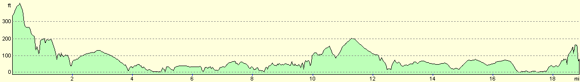
For more information on profiles, ascents and descents, see this page
Accommodation
We spent the night in the car park by the Duncansby Head lighthouse, a lovely place to spend the night with some tremendous views westwards along the north coast and south down the east coast.
Disclaimer
Please note that I take no responsibility for anything that may happen when following these directions. If you intend to follow this route, then please use the relevant maps and check the route out before you go out. As always when walking, use common sense and you should be fine.
If you find any information on any of these routes that is inaccurate, or you wish to add anything, then please email me.
All images on this site are © of the author. Any reproduction, retransmissions, or republication of all or part of any document found on this site is expressly prohibited, unless the author has explicitly granted its prior written consent to so reproduce, retransmit, or republish the material. All other rights reserved.
Although this site includes links providing convenient direct access to other Internet sites, I do not endorse, approve, certify or make warranties or representations as to the accuracy of the information on these sites.
And finally, enjoy your walking!
This walk was mentioned in the following routes:
| My walk around the coastline of Britain |
| My sectional Land's End to John O'Groats walk |
Nearby walks
| # | Title | Walk length (miles) |
|---|---|---|
| 529 | Thurso to Dunnet Head | 17.3 |
|
|

|