Walk #529: Thurso to Dunnet Head
 |
 |
|
General Data
| Date Walked | 16/08/2003 |
| County | Highlands |
| Start Location | Thurso |
| End Location | Dunnet Head |
| Start time | 10.15 |
| End time | 16.32 |
| Distance | 17.3 miles |
| Description | This was a lovely walk along the coast up to and around the western side of Dunnet Head. |
| Pack | Today I carried my 30-litre Karrimor HotRock rucksack, which was filled with my packed lunch, waterproof leggings, water bottle and a couple of spare shirts, together with the usual assortment of odds and ends. |
| Condition | I feel absolutely fine after this walk, and have no significant problems to report. My left knee ached slightly early on, but this soon passed and I had no other problems. |
| Weather | Today was generally overcast with only occasional sunshine, and there was a stiff breeze that cooled me down significantly when I was exposed to it. Although some of the clouds were quite grey, especially in the afternoon, there was no sign of any rain. |
| OS map | Landranger number 12 (Thurso & Wick, John O'Groats) |
 |
 |
|
 |
 |
|
Map of the walk
Maps courtesy of Google Maps. Route for indicative purposes only, and may have been plotted after the walk. Please let me have comments on what you think of this new format. For a detailed table of timings for this walk, please see the table file.
 |
 |
|
Notes
As we had mains power once again I spent quite a significant amount of time this morning doing a lot of work on the computer, trying to catch up with the work that I have not done over the last four days. I had a great deal of work to do, especially as I had taken many photographs, but I got them done earlier than I had expected. Sam made me some absolutely superb pancakes for breakfast. It was tempting to take a day off so that I could have a look around Thurso, but I took a day off four days ago and I could not really justify taking another day off.
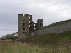
Sam walked with me for the first half mile to the mouth of the River Thurso, and it was nice having her walking beside me. It had been a late start, but I still diverted into the centre of Thurso for a quick look around, before crossing the river by the road bridge. The town is not the best that I have passed through on the walk, but it is the largest place that I have seen since Ullapool (seemingly an age ago), and therefore had a certain charm. On the eastern side of the river I passed the ruins of Thurso Castle, which had a quite impressive curtain wall. This castle intrigues me slightly, as although it is ruinous it seems of a relatively modern design, and had nice detailing in areas, such as around the windows. Just beyond the castle I had to wade through thistles that came up to my armpits, and I was particularly glad when this stretch was over.
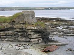
The walk along the clifftop to Castletown allowed me some fine views eastwards to Dunnet Head and northwards to the Orkneys, and these views kept me going on what otherwise may have been a boring plod. Just to the west of Castletown I passed a ruined building that I initially thought was a small hut, but on closer examination I found that it was the remains of an old gun battery made out of flagstones! The whole area has been dominated by the use of flagstones in construction, and virtually all the old buildings are made out of them. This leads the buildings to have a certain charm about them once they become ruinous, as the flagstones decay in a much more natural was than bricks or large stone blocks do.
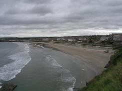
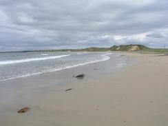
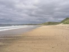
The long beach to the northeast of Castletown was surprisingly quiet, and I read the latest edition of Private Eye as I walked along. The beach was strewn wit hundreds - and perhaps thousands - of dead jellyfish, there sometimes being ten per foot of beach at the tide line. The vast majority of these were of a transparent variety and small in size, and there were only a few larger brown ones. At the northeastern end of the beach there were a few surfers about, enjoying the long rolling waves that were breaking onto the shore, and once I got slightly above them on the cliffs I watched them for a few minutes. Surfing is not exactly my idea of fun, but they certainly seemed to be enjoying themselves!
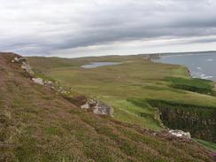
The walk from the beach around the cliffs to Dunnet Head was along some beautiful moorland, and I cold make good progress along the ground, which was mostly level with only occasional climbs. In places there was quite a wide path through the heather, but in others I had to follow tiny sheep tracks exhilaratingly near to the edge of the cliffs. The erosion to the cliffs was very much of the kind that I had seen yesterday afternoon, with some long vertical cracks running inland by twenty or thirty yards. I had to be careful not to fall into any of these, but I could not resist the temptation of looking down into the sea from them.
Dunnet Head is the northernmost point on the mainland of Britain, and as such is the fourth cardinal point that I have visited on the walk, after the easternmost point (The Ness in Lowestoft), the southernmost (the Lizard), and the westernmost (Ardnamurchan Point). The Lizard feels like it was a very long time ago, and I have travelled an awfully long way north since then. Now then I have done all four cardinal points I feel like a chapter of the walk has finished, and that it is downhill all the way from now on.
The view from the car park this evening as the sun went down was superb - the Orkney Islands were clearly visible, and as the light went down we could see a distant flare on one of the islands, probably from an oil installation. One of the most magic aspects of this walk has been the views that we get from Mervan at night; most nights these are nothing to write home about, but at others they have been magical and even spiritual, and tonight is one of these nights.
Tomorrow will very much be a red-letter day of the walk so far - reaching John O'Groats will be an amazing feeling, especially as Land's End was such a long time ago. As well as finishing a Land's End to John O'Groats walk in one go around the west coast of Britain, I shall also be completing my 1,600-mile section LE-JOG walk that I started in 1999 (the last leg of which was along the north coast of Scotland from Cape Wrath to John O'Groats), and so this will definitely be worth a whisky or three.
Directions
This walk starts off at the campsite in Thurso. Leave the campsite and follow the path that runs eastwards along the top of the cliffs. The path drops down to join the Esplanade, and follow this until it ends at a point at the mouth of the River Thurso. Turn right and walk south along the western bank of the river along Rivrside Road, passing some public toilets before reaching the Ellan footbridge over the river. I continued a short distance further on into the town and crossed the river by the road bridge at Georges Street. I then followed the road eastwards and then turned left up St Archibald Road. When this road ends near the mouth of the river a path continues on along the coast, passing the curtain wall of Thurso Castle and then passing under the castle itself.
A good path continues onwards along the coast to the northeast. When the path eventually peters out near Clardon Head continue on along the clifftop around Clardon Haven and on to the beach at Murkle Bay. The low cliffs can be followed around for another couple of miles until a car park is reached beside the road in Castlehill. Join the road and follow it southeastwards past a pier and then join the beach beside Dunnet Bay. Walk northeastwards for a couple of miles along the beach until it ends, and then climb up onto the cliffs and turn left to follow the edge of the cliffs westwards. After a cottage there are another couple of fields, before a road is met beside Dwarwick Pier.
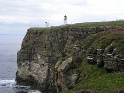
From the pier climb steeply uphill along a path that leads over Dwarwick Head, and continue on following a narrow path that skirts the edge of the cliffs towards a little beach, after which it climbs up and heads between the cliff edge and the Loch of Bushta. A descent down to a stream is then followed by a steep ascent up the side of Dunnet Hill, again following the cliff edge. Eventually the ground flattens out and the last couple of miles made for a lovely walk across moorland beside the cliff edge, with some superb views out to the Orkneys. At the lighthouse complex join the road by the gate through the wall and turn left to the car park in the complex, where this walk ends.
Distances
| From | To | Distance (m) | Ascent (ft) | Descent (ft) |
|---|---|---|---|---|
| Thurso | Castletown | 8.5 | 466 | 509 |
| Castletown | Dunnet Head | 8.8 | 2726 | 2398 |
This makes a total distance of 17.3 miles, with 3192 feet of ascent and 2907 feet of descent.
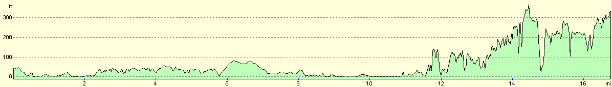
For more information on profiles, ascents and descents, see this page
Accommodation
We spent the night in the car park beside the lighthouse at Dunnet Head, which had some superb view past the lighthouse to the Orkney Islands.
Disclaimer
Please note that I take no responsibility for anything that may happen when following these directions. If you intend to follow this route, then please use the relevant maps and check the route out before you go out. As always when walking, use common sense and you should be fine.
If you find any information on any of these routes that is inaccurate, or you wish to add anything, then please email me.
All images on this site are © of the author. Any reproduction, retransmissions, or republication of all or part of any document found on this site is expressly prohibited, unless the author has explicitly granted its prior written consent to so reproduce, retransmit, or republish the material. All other rights reserved.
Although this site includes links providing convenient direct access to other Internet sites, I do not endorse, approve, certify or make warranties or representations as to the accuracy of the information on these sites.
And finally, enjoy your walking!
This walk was mentioned in the following routes:
| My walk around the coastline of Britain |
| My sectional Land's End to John O'Groats walk |
Nearby walks
| # | Title | Walk length (miles) |
|---|---|---|
| 528 | Melvich to Thurso | 21.6 |
|
|

|