Walk #528: Melvich to Thurso
 |
 |
|
General Data
| Date Walked | 15/08/2003 |
| County | Highlands |
| Start Location | Melvich |
| End Location | Thurso |
| Start time | 09.30 |
| End time | 18.19 |
| Distance | 21.6 miles |
| Description | This was a lovely walk, with some superb views along the coast and north to the Orkney Islands. |
| Pack | I used my new Highlands water hydration pack, which contained a two-litre water bottle, some spare batteries and a couple of chocolate bars. |
| Condition | This was quite an unusual day, in that I started off with my left knee hurting, at lunchtime my right knee was hurting and by the time I finished my left ankle was aching! Fortunately none of these happened at the same time, and I could put the pain to the back of my mind for most of the time. |
| Weather | There was yet more wind and cloud this morning, but fortunately there was no rain. As the day drew on the cloud lessened, and it turned out to be a lovely day, although the wind was quite biting at times. |
| OS map | Landranger number 10 (Strathnaver, Bettyhill & Tongue), Landranger number 11 (Thurso & Dunbeath) and Landranger number 12 (Thurso & Wick, John O'Groats) |
 |
 |
|
 |
 |
|
Map of the walk
Maps courtesy of Google Maps. Route for indicative purposes only, and may have been plotted after the walk. Please let me have comments on what you think of this new format. For a detailed table of timings for this walk, please see the table file.
 |
 |
|
Notes
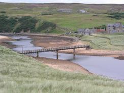
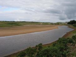
When I woke up this morning my left knee was quite stiff, and if I raised it up high I got a fairly intense pain underneath it. I sprayed it liberally with deep heat before I set off, and hoped that it would help to improve matters. It had been my intention to walk around the cliffs towards Dounraey, but the pain in my knee scuppered that plan and so I chose to walk along the road, which runs close to the coast anyway. I did divert off the road for the first section, however, as there is a nice footbridge over the Halladale River that I could use. This river is really very nice, and I walked around a little so that I could take some varied photographs of it before making my way along he road back to the A836 road.
The next stretch of walk as far as the little village of Raey was quite unremarkable, and I motored along it until I got near to the village. Here I had hoped to divert around tracks past Sandside House to Fresgoe and Sandside Head, but the entrance to the tracks from the road were blocked by a seemingly large construction plant, with large five-ton dumpers going in and out from the main road. This did not devastate me, and so I just continued on into the village. I nipped into the little shop in the village to buy myself refreshment, and I ended up chatting to the proprietor for a while about the walk.
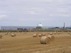
Sam was waiting for me at the Dounraey nuclear power station visitor centre, and so I tried to keep a good pace up for the last section to the centre. Mervan was waiting for me in the car park, and so after I had taken the hydration pack off Sam and I went into the centre. Dounraey is the home of the Nuclear Power Research Establishment, and it had two main experimental reactors - the Dounraey Fast Reactor (housed in an archetypal nuclear power plant globe), which opened in 1958 and was closed in 1977, and the Prototype Fast Reactor, which was opened in 1974 and shut down in 1994. As both of the reactors are closed, Dounraey is bring used as an experiment to work out the best way of decommissioning nuclear sites, and the visitors centre now goes into details of this work. The costs are massive, but the intention is to leave a brownfield site with only the dome of the Dounraey Fast reactor standing. This will take over sixty years to accomplish, but I found the details absolutely fascinating. The DFR cost only fifteen million pounds to build, but in 2000/2001 alone 130 million pounds will be spent on the decommissioning of the site! As someone who has always been fascinated by process I found the information to be absorbing, particularly the details of one small part of the process - emptying a large underground shaft that had been filled with intermediate level wastes.
Unfortunately as I walked around the site I found that my right knee started hurting a great deal - this was strange, as my left knee that had been hurting this morning had stopped hurting just in time for the other one to start! I picked up lots of informational brochures in the centre (which is housed in an old aircraft control tower), which I shall peruse over the next few days. After we had finished in the centre we went back down to Mervan and had some lunch, which helped provide me with some much-needed fuel for the rest of the day.
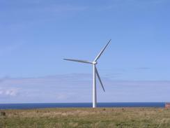
After lunch my right knee unseized itself and I found that I could walk much easier, and so I decided to head off along the coast. I left the A836 road and passed the Hill of Lybster (complete with two wind turbines) on a track before coming to a large and imposing metal fence that was being pulled down by contractors. I therefore skirted this area, and headed past St Mary's Well (simply a spring coming out of the ground) and reached the ruins of St Mary's Chapel. This is a delightful little ruin with very low doorways, but it is unfortunately ruined by the close proximity of a small factory site that is guarded by the high fences. I looked around the church for a little while before making my way along the coast to Crosskirk and Brims Ness, where I came across the ruinous Brims Castle, now part of a working farm. I diverted inland here to avoid a field full of young bulls, and it amused me that this was the first time that I have had to do this since near Stranraer, which feels like an eternity ago!
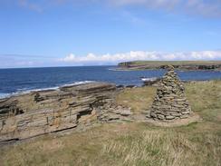
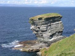
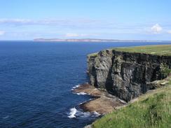
The cliffs on the last section of this walk to Holborn Head were fantastic - large, horizontal expanses of metamorphic rock exposed by the sea. There were several impressive stacks eroded by the sea into grotesque shapes, and the cliffs themselves were impressive and in places high. Near the Ness of Litter there is the remains of an old quarry that you can walk through, and I enjoyed looking at the flat expanses of the stone that had been exposed by the workings - in places it was extremely flat. The stone is used for, amongst other things, field boundaries, and instead of building a drystone wall as they would in my native Derbyshire; they just put the flat stones vertically into the ground, making a very effective and easy barrier! Even the campsite in Thurso that we are staying in tonight has such a border, and I can only recall seeing other such field boundaries in North Wales.
I eventually reached the headland at Holborn Head, where I turned right to head south towards the port at Scrabster. At Holborn Had there were some dramatic blowholes in the cliffs that were unfenced off, and I got as close as one as I felt safe (not very!) so that I could have a look down into one of them. It was another example of how dramatic the coastal scenery in the area is. I passed through the port of Scrabster (the main port for the Orkney Islands), and then headed over the cliffs to the campsite on the outskirts of Thurso where Sam was waiting for me. This ended an absolutely superb day's walk, and I can hardly wait for tomorrow's walk around Dunnet Head, the last cardinal point of the entire trip.
Directions
This walk starts off at the Melvich Hotel in Melvich. Head east along the road for a few hundred yards before turning to the left down a track that leads down to the beach beside Melvich Bay. Here there is a little pedestrian footbridge over the Halladale River. Cross the bridge and on the other side turn right along a road that heads through Brighouse before ending at a T-junction with the A836 road. At the junction turn left and walk eastwards along the A836 road towards the village of Raey. Here the road turns to head northeastwards, passing the Dounraey Nuclear Power Development Establishment and continuing on. When the road curves to the right turn left down a road that heads north past the Hill of Lybster and two wind turbines.
When the fence of a factory is reached turn right and follow the edge of the fence down to the coast by the ruins of St Mary's Chapel. Here turn left and follow a distinct path eastwards along the coast for a short distance to the little bay at Crosskirk. Cross a bridge over Forrs Waters and then climb up onto the cliffs to the left. Follow the cliffs around northwards towards Ushat Head, and then head east into Port of Brims and past the farm at Brims Castle. Continue on eastwards along the coast as it heads eastwards, slowly climbing uphill towards an old flagstone quarry at the Ness of Litter. Walk through the quarry and then continue on eastwards along the cliffs past Spear Head to Holborn Head.
At Holborn Head turn right and follow a distinct path along the cliffs southwards, which eventually descends to the Holborn Head lighthouse. Here join a small road that soon lead to Scrabster port and becomes the A9(T). Follow the road as it climbs uphill onto the cliffs, and then turn left along a private road that soon becomes a path as it skirt the edge of the cliffs. The path becomes East Gill, which eventually joins the A9(T) Scrabster Road. Take the first road to the left (Burnside), which almost immediately joins a footpath that heads eastwards past Chapel Point to the campsite at Thurso, where this walk ends.
Distances
| From | To | Distance (m) | Ascent (ft) | Descent (ft) |
|---|---|---|---|---|
| Melvich | Dounreay power station | 9.0 | 545 | 659 |
| Dounreay power station | Thurso | 12.6 | 2274 | 2333 |
This makes a total distance of 21.6 miles, with 2819 feet of ascent and 2992 feet of descent.
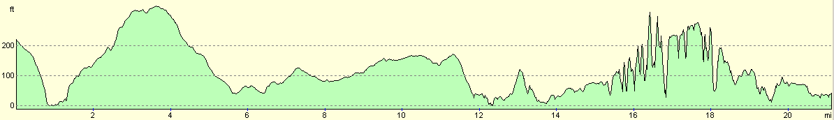
For more information on profiles, ascents and descents, see this page
Accommodation
We spent the night at the Thurso Caravan and Camping Park, Scrabster Road, Thurso, Highlands KW14 7JY. This should have cost us ú12.40 for the night, but they kindly gave it to us for free. They can be contacted on (01847) 805508. This was a nice site that is close to the centre of Thurso, and has lovely views over to the Orkney Islands.
Disclaimer
Please note that I take no responsibility for anything that may happen when following these directions. If you intend to follow this route, then please use the relevant maps and check the route out before you go out. As always when walking, use common sense and you should be fine.
If you find any information on any of these routes that is inaccurate, or you wish to add anything, then please email me.
All images on this site are © of the author. Any reproduction, retransmissions, or republication of all or part of any document found on this site is expressly prohibited, unless the author has explicitly granted its prior written consent to so reproduce, retransmit, or republish the material. All other rights reserved.
Although this site includes links providing convenient direct access to other Internet sites, I do not endorse, approve, certify or make warranties or representations as to the accuracy of the information on these sites.
And finally, enjoy your walking!
This walk was mentioned in the following routes:
| My walk around the coastline of Britain |
| My sectional Land's End to John O'Groats walk |
Nearby walks
| # | Title | Walk length (miles) |
|---|---|---|
| 527 | Bettyhill to Melvich | 21.3 |
|
|

|