Walk #921: Great Glen Way: Fort William to Laggan
 |
 |
|
General Data
| Date Walked | 14/09/2011 |
| County | Highlands |
| Start Location | Fort William (GGW) |
| End Location | Laggan YHA |
| Start time | 07.42 |
| End time | 15.41 |
| Distance | 23.8 miles |
| Description | This walk follows the Great Glen Way northeastwards from its start point in Fort William, following the Caledonian Canal to Gairlochy and the western shore of Loch Lochy to Laggan. |
| Pack | Today I carried my 30-litre Karrimor rucksack, filled with water, my waterproofs, a book and other odds and ends. |
| Condition | I feel very tired after this walk, but am otherwise okay. |
| Weather | Sunshine and drizzle dominated today's weather, with most of the sunshine at the beginning and the drizzle towards the end. It was quite a warm day despite this, and this allowed me to dry off quickly after the showers. |
| OS map | Landranger number 41 (Ben Nevis, Fort William & Glen Coe) and Landranger number 34 (Fort Augustus, Glen Albyn & Glen Roy) |
 |
 |
|
Map of the walk
Maps courtesy of Google Maps. Route for indicative purposes only, and may have been plotted after the walk. Please let me have comments on what you think of this new format. For a detailed table of timings for this walk, please see the table file.
 |
 |
|
Notes
Just over ten years ago I walked the middle two-thirds of the Great Glen Way as part of a walk from Fort William to Cape Wrath. That journey was slightly more adventurous than I would have liked, and I have always wanted to complete the top and bottom segments of the trail. I therefore set off from Cambridge yesterday in what turned out to be a ten-hour drive to Fort William. The Bank House Lodge was full, so I travelled a couple of miles out of the town to a rather good hostel in Banavie before having dinner at the Lochy Inn and going to bed, tired to my core.
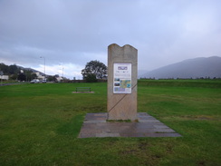
I awoke early in the morning but waited until after seven before heading off. Sun was streaming through the hostel's window as I left, but by the time I parked in the long-stay car park (£1.50 per hour) by the station in Fort William it had started drizzling. It was annoying to be starting the trail in the rain, but an upside was a rather lovely rainbow over Loch Eil. Because it was only a light drizzle I headed off with just my black fleece on as I walked to the stone monument that marks the Great Glen Way's western trailhead.
The rain got heavier as I took photos of the monument so I headed off fairly immediately. Unfortunately the downpour increased and I was soon hiding under a petrol station canopy as I put my coat on. I then made my one and only mistake of the day - I took the wrong path out of the town, following a road instead of a path. The mistake was easily rectified and I soon rejoined the trail at a shinty pitch.
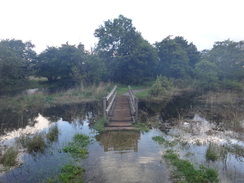
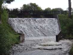
Shortly after this the trail crossed a bridge over the River Nevis and soon afterwards the path split; the main path was guarded by warning of floods, and the other was a wet-weather alternative. Despite the rain I chose the former and was soon heading through a delightful area of sparse woodland. I soon came across the floods - two footbridges that were so close to the water that the planks sploshed into it as I crossed. Crimson carriages soon became visible off to the right, above which was some smoke - I guess a steam locomotive getting ready for a journey to Mallaig.
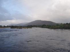
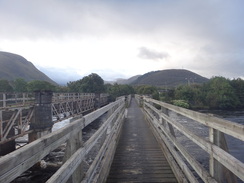
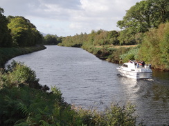
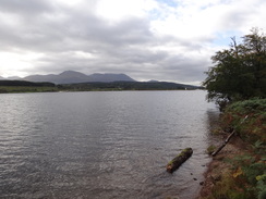
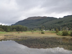
Both the path and the weather had dried out by the time the Soldier's Bridge came into view. This wooden structure spans the River Lochy beside a rather more substantial railway bridge, and it took me safely across the water to a road on the other side. It got its name because soldiers built it, and it seems to be a well-used alternative to the road bridge. There is not much to be said about the next mile or so of the walk which took me along roads and along the northern shore of Loch Linnhe. Two boats were heading towards the sea lock on the Caledonian Canal, and the summit of Ben Nevis behind me was firmly wreathed in clouds.
A nostalgic feeling swept over me as I followed the road. This is frequently the case when I re-walk parts of the coast that I did on my CoastWalk, that trip having formed countless memories. These came flooding back as I walked, not just this area but of the entire coast towards Ardnamurchan. Part of me wanted to abandon the trail and just follow the coast westwards. In the end sanity won and I resolved to finish this trail - the coast could wait for another visit.
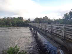
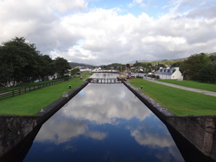
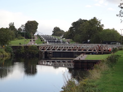
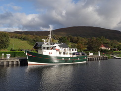
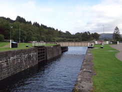
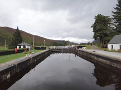
A path led me on to the main objective of the trail - the Caledonian Canal. I stopped to take a few photos of a lock before heading off along the towpath. After passing the Lochy pub, where I ate last night, I approached the two swing bridges that takes the railway and the main road to Mallaig over the canal, and then reached the bottom of Neptune's Staircase. This set of locks is really quite special - they are far broader than most locks in this country (having been designed to take sea-going ships) and stride imperiously up the hillside. It is a magnificent sight, although it is a shame that the close-set locks mean that the best views can only be obtained from the air.
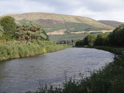
Sadly the top of the incline was the start of what was a fairly ordinary six mile stroll along the towpath of the Caledonian Canal. Some of the views over the hills to the west were superb, but only silvery glints of the River Lochy could be seen through the surrounding trees. The sun had come out, however, meaning that I was soon roasting in both my fleece and coat.
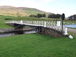
I did not bother to divert off the trail to examine either of the two aqueducts on the route, but I was impressed by the superb iron swing bridge at Moy. This is the only manual bridge on the canal, and as it is in two halves the operator has to go across the canal in a boat to open the other side. This must be a rather convoluted and time-consuming procedure, but the operator certainly did not seem to mind. An information board told a story of how a ship's captain had been fined when he had gone through the bridge without it being opened - one can only assume the boat pushed it open.
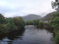
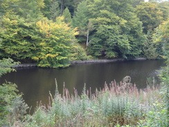
The towpath climbed up about twenty feet above the canal before dropping down once more to rejoin the canal. It must have been hard for horses to pull boats along this section and this led me to wonder if boats ever sailed through the canal. Soon I came across a wonderful section of path, with the canal to the left and the wider, shallower River Lochy to the right, the latter complete with fishermen sanding waist-deep in the raging waters.
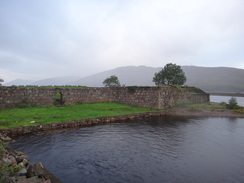
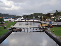
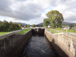
I was thankful when the canal took me out to the lock and swing bridge at Gairlochy. Two men were lifting their canoes out of the water at the bottom of the lock, and I met up with one of them at the swing bridge that carries the main road over the river. They were both rowing the canal and were planning to take four days to reach Inverness - the same time it would take me to walk it. I had heard rumours of a cafe here, but I knew that I was pressed for time if I was going to catch the 16.06 bus and so pressed on. The lock was open; apparently it is kept open most of the time and is only closed during exceptional weather.
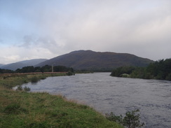
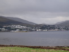
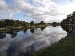
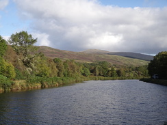
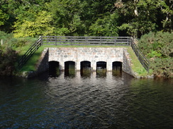
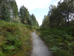
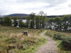
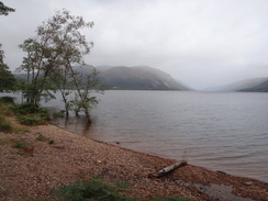
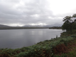
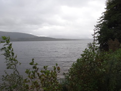
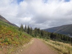
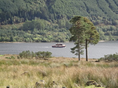
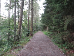
Initially the path followed the road, but soon it diverted off uphill along a path. Soon afterwards it crossed the road and headed down towards the shoreline. What followed was the best bit of trail I saw all day - a rollercoaster of a path through sparse woodland that granted superb views across the length of Loch Lochy. The whitewashed pepperpot hat guides boats into the lock was visible behind, and ahead the clouds threatened more rain. I was in heaven as I strolled confidently along paths that were lined with red and white mushrooms.
The magnificent Glenfintaig House became visible on the other side of the loch, its whitewashed walls contrasting with the grey-blue of the water and the greens of the wooded hillside behind. Sadly the path had to end, and it unceremoniously dropped me back onto the road.
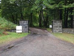
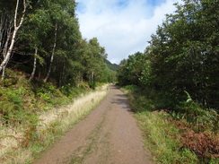
This took me on towards Achnacarry, where I knew that there was a museum dedicated to the Clan Cameron that I would not have minded visiting. Sadly a sign stated that this did not open for another hour, so instead I strode on along the road which passed through a area with a very colourful collection of broad-leaved trees; yellows, greens and vivid reds all being visible. It was a spectacular display, but must be superb in a few weeks during the height of autumn. The road soon led onto a track at Clunes, which passed a forest school before heading on.
Last time I walked this way - over ten years ago - I had done so in the company of an American who was carrying a large roll-bag in each hand rather than a rucksack. It looked terribly uncomfortable, but his insistence on asking me the Latin name of each tree we passed proved incredibly grating and it was a relief when we parted company. I have walked many thousands of miles since, but have never come across someone quite like that gentleman.
A runner came past in the opposite direction; Leslie Spiers was raising money for the Motor Neurone Disease Association, which sadly claimed his dad. We stopped to chat for a couple of minutes and, unlike the American, he was totally inspiring - a really top man.
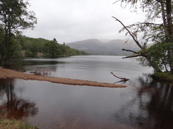
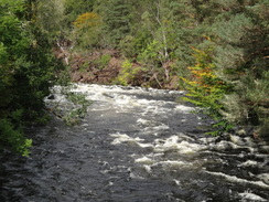
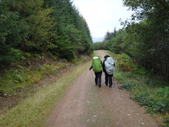
I soon overhauled a couple walking in the same direction and we walked together for the rest of the day. They were from Belgium and annoyingly young, but I could forgive them that as they turned out to be absolutely A1 company. We chatted as we walked along, admiring the white torrents of rushing water that burst down the hillsides and the occasional views that unfolded across the loch.
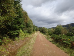
The couple had started off from Fort William on Tuesday, and therefore had caught the worst of yesterday's rain. A kind landlady had dried all their clothes after they realised that their rucksack covers were not quite as waterproof as they had hoped. The miles just flew by in their company, which was a good thing as the track itself was far from interesting. Gaps in the trees offered occasional tantalising glimpses over the loch below, but these were few and far between. Instead we chatted away - perhaps I should try doing less solo walking in future...
Sporadic bouts of light drizzle proved annoying rather than bothersome, and indeed I was overheating in my coat. Eventually civilisation intruded in the form of wooden holiday huts, and soon afterwards I had to explain to the Belgians what a cattle grid is! It is surprising the way that something that can seem ever-present and obvious can be unusual for someone with different life experiences. I left them behind at Laggan Locks and walked on, but they caught me up as I left the trail and joined the main road.
They were spending the night at the Great Glen Hostel, which is just down the road. My stopping place was a bus stop which, according to the timetable, was 150 metres north of the hostel beside a postbox. This seemed rather like instructions from a spy novel but sure enough there was a postbox at the right place, right beside a muddy lay-by. However there was no sign of a bus stop and so I was nervous right until the bus pulled up beside me. The journey back was enlivened by part of the ceiling falling off and hitting a passenger; fortunately she was only bruised, but it could have been much worse if it had hit her on the face. I must remember not to sit under large signs in the front of a coach...
Once back in Fort William I walked the short stretch of path that I had missed off this morning, then headed off to the nearby McDonalds. I am not really a fan of their food but sometimes I have a creeping desire for it. It had been a long and memorable day's walk which had been enlivened by some good company.
For years there was no marked starting point of the Great Glen Way in Fort William, but recently a little monument was erected as an official starting point (there is a similar monument at the other end of the trail in Inverness, which hopefully you will see in a few days). This monument is at NN105742, on the grass in the old fort and opposite the car park of a Morrisons Store. It is only a short walk away from the railway station.
Follow the road northeastwards for a short distance to a roundabout, passing a little inlet on the left; there is a pavement on the left. Take the second road off this roundabout and follow it heads straight on, passing a McDonalds and a pub on the right and a fire station on the left. The road soon becomes a path that continues northeastwards, soon reaching a raised bank on the right, on the other side of which is a shinty pitch.
At the end of the shinty pitch the path curves to the right and, after passing a house on the left, turns left to reach a road called Camanachd Crescent. Turn right along this for a few yards and then left between houses to reach a bridge over the mouth of the River Nevis. Here there are two alternative routes; a road route for use in wet weather and a much prettier riverside path that can flood in bad weather.
(road route)
The path continues straight on for a short distance before jinking to the left and then right to continue northeastwards along Inverlochy Court. When the road ends continue between two bollards to join a path. The path skirts houses on the right; when the main path jinks to the right after a couple of hundred yards continue straight on along an area of grass. It passes three houses on the right and continues eastwards with a stream on the left. After a quarter of a mile it meets a track beside the railway line; turn left and start following the track northeastwards with the railway line to the right. At NN119753 the riverside path is rejoined.
(riverside route)
After crossing the bridge over the River Nevis, immediately turn left along a path that leads through trees to the bank of the River Lochy. This path soon curves to the right to parallel the riverbank; when the path forks, take the right-hand fork which soon curves to the left. It crosses the end of a track and continues on through the trees with grand views over the river and loch to the left before reaching a couple of footbridges over streams; the areas around the bridges can flood after heavy rain or at high tides. The path leaves the trees and curves slightly to the right, still keeping the River Lochy roughly to the left. Shortly after leaving the trees go through a clapper gate and continue on to two field gates. Go through a clapper gate beside the gates to join a surfaced track at NN119753; turn left down this track with the railway line on the right. Here the alternative route is rejoined.
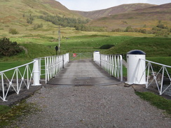
The track crosses a bridge over the ugly concrete tailrace from the Fort William aluminium factory before curving to the right to head under the railway line. Do not turn right, and instead climb a ramp to the left that leads onto the narrow Soldier's Bridge footbridge over the River Lochy. Climb the ramp onto the bridge and cross it, with the railway bridge on the right. At the end of the bridge turn left to take a ramp that leads up to the left onto the B8006 road. Turn left and follow the road as it heads in a rough westerly direction beside a tributary of the river; there is a pavement on the right-hand side of the road.
Shortly after the road curves to the right, turn left to head southwestwards down Glenmallie Road. This soon swings to the right, becoming Erracht Terrace. Follow this road northwestwards; when it reaches a small parade of shops on the right it curves to the left and right to continue paralleling the shore. When the road ends continue straight on across a gravel path past playing fields, keeping the shore of the loch to the left.
At the end of the playing fields the path curves to the right, crossing a bridge over an outfall from the canal and heading up a slope to reach the canal's towpath beside a lock. Climb the bank and turn right to follow the gravel towpath southeastwards with the canal on the left; it soon curves to the left to start heading northeastwards. Just after the Lochy pub is passed on the right at NN111767, turn right down a grassy path that slopes down to reach a road. Turn left and follow this road as it curves to the right and then left to reach a level crossing over a railway line. Shortly afterwards the road ends at a T-junction with the A380(T).
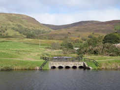
Carefully cross the A380(T) to reach a pavement on the northern side of the road, then turn left to follow the pavement back towards the canal. Just before the Banavie Swing Bridge over the canal is reached turn right, squeezing past a metal gate and the building controlling the swing bridge to join the towpath beside a canal lock. This is the first of the flight of eight locks called Neptune's Staircase that lifts the canal up 64 feet. Follow the towpath as it follows the locks uphill on the left to reach the summit level. At the top go through a metal field gate; from here it is simply a case of following the towpath northeastwards for 6.4 miles, keeping the canal to the left all times. It passes over a couple of aqueducts and the pretty Moy Bridge. Eventually it passes Gairlochy Bottom Lock, passes a canalside building and goes through a gate to reach the B8004 road in Gairlochy at NN176841.
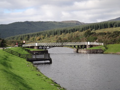
From Gairlochy Bottom Lock at NN176841, turn right to cross the swing bridge over the canal and continue along the road. As it curves to the left, turn right to head uphill along the B8005 road in a north-easterly direction. Pass a road junction on the left and shortly afterwards at NN177844 turn left along a gravel footpath. This climbs uphill slightly before curving to the right to contour through the woodland above the road. The path soon descends back to the road at NN181848; as it does so turn left along the road for about five yards to reach a Great Glen Way trail marker that points downhill to the right.
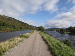
Turn right and follow the path as it descends to the shoreline of Loch Lochy; it then follows the shoreline northeastwards. The path underfoot is often gravel, and it crosses four footbridges as it winds, climbs and falls. Despite these changes of direction the path is easy to follow. One and a half miles after leaving the road the path curves to the left away from the shore, climbing uphill to rejoin the road at NN185867.
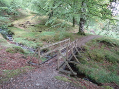
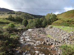
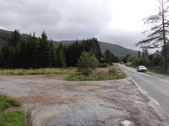
The road winds around the hillside through a forestry plantation, gaps in the trees giving tantalising glimpses of the southern reaches of Loch Lochy. After a third of a mile at NN183870 pass the junction with the road which leads up to Achnacarry, then immediately cross a bridge over a pretty stream. Continue along the road for half a mile around a little bay to cross a bridge over the River Akraig at Bunarkaig. About a mile further on the road crosses the Allt Bhan burn at Clunes. Shortly after the bridge it passes three wooden houses on the right and curves sharply to the left at NN200886; here turn right to join a forestry road.
Follow the forestry road as it becomes a track and starts to head through the forest, soon passing Clunes Forest School on the right, which is situated in two wooden barns. It climbs slightly to reach a little car park situated on a bluff above the loch; pass the car park and follow a track as it curves to the left, heading through a field gate. Immediately after the gate the track forks; take the right-hand, lower, branch. The trail is very easy to follow as it heads north-eastwards parallel to the northern shore of Loch Lochy. It slowly rises and falls as it crosses a series of bridges over streams. After 6.6 miles it makes one last ascent, passing a large quarry on the left before meeting another track coming in from the left. Turn right and follow this track as it descends, crossing a cattle grid and passing some lodges on the right to meet a surfaced road at the bridge over the Kilfinnan Burn at NN277957.
Follow the road as it immediately crosses the Kilfinnan Burn; continue straight on along the road for nearly half a mile until it reaches a fork in the road at NN282963. Do not take the branch that heads straight on up the hillside, but instead take a track that leads off across a cattle grate to the right. This soon curves to the right and passes holiday chalets on the left before crossing a flat area of ground to reach the two Laggan Locks at NN285963.
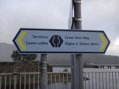
Cross over the canal at either of the locks and then turn left to head northwards along a path that follows the eastern bank of the canal. When the path splits take the higher path that continues on top of a bank above the canal towpath. It enters a wooded area and climbs to quite a height above the lock; it finally emerges just before a wooden footbridge across a stream. Here the trail is left for the day; turn right down a track for a few yards to reach the A82 road. Turn right to head south down the road; the Laggan hostel is about two hundred yards away on the right, whilst the bus stop is by a post box next a track exit onto the road at NN294973.
This makes a total distance of 23.8 miles, with 1562 feet of ascent and 1453 feet of descent.
To get between Laggan and Fort William, I used the Scottish CityLink service 919 that runs between Inverness and Fort William. This service runs every couple of hours during the day, although less frequently during the winter timetable. The bus stop is at a lay-by beside a psotbox a little north of Laggan Youth Hostel; the service also calls at Spean Bridge, a couple of miles from Gairlochy if you wish to have a shorter stroll.
I spent the night at the Chase the Wild Goose hostel, situated right beside Neptune's Staircase in Banavie a couple of miles from the centre of Fort William. This hostel was good value at £14.50 for the night, and there were several places to eat a short stroll away.
Please note that I take no responsibility for anything that may happen when following these directions. If you intend to follow this route, then please use the relevant maps and check the route out before you go out. As always when walking, use common sense and you should be fine.
If you find any information on any of these routes that is inaccurate, or you wish to add anything, then please email me.
All images on this site are © of the author. Any reproduction, retransmissions, or republication of all or part of any document found on this site is expressly prohibited, unless the author has explicitly granted its prior written consent to so reproduce, retransmit, or republish the material. All other rights reserved.
Although this site includes links providing convenient direct access to other Internet sites, I do not endorse, approve, certify or make warranties or representations as to the accuracy of the information on these sites.
And finally, enjoy your walking!
Directions
Distances
From To Distance (m) Ascent (ft) Descent (ft) Fort William Corpach station 4.5 95 89 Corpach station Gairlochy 6.4 295 226 Gairlochy Clunes 4.3 358 305 Clunes Laggan hostel 8.6 814 833 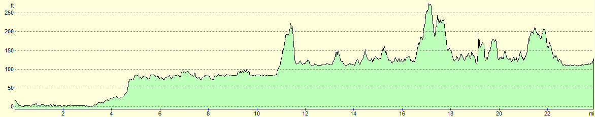
For more information on profiles, ascents and descents, see this page
Transport
Accommodation

Disclaimer
Nearby walks
| # | Title | Walk length (miles) |
|---|---|---|
| 153 | Kinlochleven to Fort William | 14.1 |
| 154 | Ben Nevis from Fort William | 11.8 |
| 185 | Fort William to Glenfinnan | 15.2 |
|
|

|