Walk #920: Viking Way: Barnetby le Wold to Barton upon Humber, and across the Humber bridge
 |
 |
|
General Data
| Date Walked | 31/08/2011 |
| County | Humberside |
| Start Location | Barnetby station |
| End Location | Barton-Upon-Humber station |
| Start time | 06.43 |
| End time | 13.33 |
| Distance | 19.4 miles |
| Description | This pleasant stroll followed the Viking Way as it heads north for fourteen miles to its northern trailhead at Barton-upon-Humber. After this I crossed and recrossed the Humber Bridge before making my way to the railway station. |
| Pack | Today I carried my 30-litre Karrimor rucksack, filled with water, my waterproofs, a couple of books and other odds and ends. |
| Condition | The underside of my feet really ache after this walk; my feet have overheated and realy suffered towards the end of the day. |
| Weather | Today's weather was dominated by light, high cloud with occasional sunny periods. It was quite warm, but there was a slight breeze to help me keep cool. |
| OS map | Landranger number 112 (Scunthorpe & Gainsborough) and Landranger number 106 (Market Weighton & surrounding area) |
 |
 |
|
Map of the walk
Maps courtesy of Google Maps. Route for indicative purposes only, and may have been plotted after the walk. Please let me have comments on what you think of this new format. For a detailed table of timings for this walk, please see the table file.
 |
 |
|
Notes
My task for the day was to complete the Viking Way. Fortunately I had only fourteen miles left before I reached the end of the trail beside the Humber at Barton-on-Humber, which promised to be an easy stroll. I woke early and set off for the short drive from my campsite near Caistor to Barnetby station, where I had ended yesterday's walk. I parked up and got my kit together before heading off down the road. I soon stopped at a little newsagents a short distance up the road, only to end up chatting with the lady behind the counter for a good five minutes. Human contact can be rare on my walks and I tend to take any opportunity to chat that I can find, especially when that contact is so friendly.
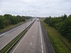
The road took me uphill towards the A18, and then across a bridge over the end of the M180 motorway. The traffic noise was very obtrusive, although the early hour meant that the traffic was not too bad; it was definitely the worst road crossing on the entire trail. It was a relief when an old dead-end lane headed away from the roundabout; this soon became a green lane that slowly descended to reach a road. Another path led off northwestwards, passing the site of the old Elsham airfield on the left; this closed shortly after the Second World War and has now been neatly bisected by the A15(T) that leads to the Humber Bridge.
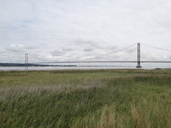
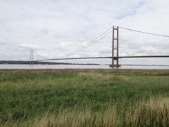
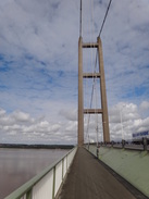
I got my first view of the bridge as I followed the path as it angled towards the main road, the massive twin towers sticking up above a hedgeline off to my right. A thin silver-grey line further to the right marked the Humber, again a tantalising indication of my final destination. Unfortunately the next couple of miles were fairly noisy as the trail paralleled the main road before finally crossing it on a bridge. Rather pedestrian paths took me onwards, the only thing of note being the towers of the bridge that slowly grew larger as I approached them.
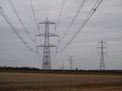
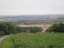
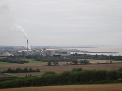
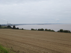
So far the scenery of this part of the trail had been distinctly underwhelming with few good views. This changed as a road took me westwards past Horkstow Wolds, when magnificently expansive views suddenly unfolded to the west. The chimneys of a large cement works were visible beside the Humber at Ferriby Sluice, and the twin sets of high-tension power lines could be traced as they stretched off towards Scunthorpe.
The trail paralleled the edge of the slope northwards, and thankfully the large hedge on the left had frequent gaps that granted me more views. A conveyor belt stretched up from a quarry beside the trail towards the cement works; obviously they get their raw materials for the cement from the quarry. Slowly the track descended to meet the A1077 in South Ferriby, after which another track led on towards the southern bank of the Humber.
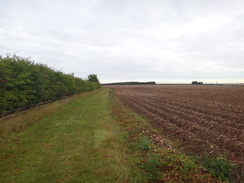
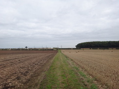
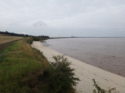
Repeated gunshots were coming from an old quarry to the right and it was here that I chose to go repeatedly wrong. It took me two attempts to find the proper course of the trail as it headed down towards the foreshore, the new route (as shown by markers on the ground) being slightly different to that shown on the map. Unfortunately the field beside the path had been ploughed and I was forced to walk along a narrow strip of grass between the muddy field and the edge of the low cliffs.
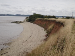
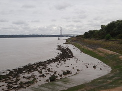
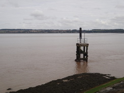
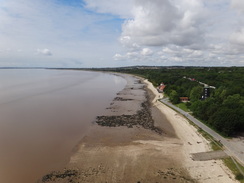
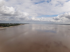
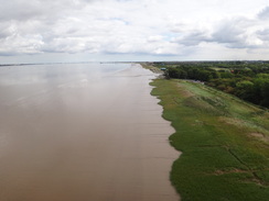
South Ferriby Cliffs were interesting - they were made of a reddish friable clay that sloped down towards a beach of white pebbles. This was set against the brown, muddy waters of the Humber and gave the scene a fair amount of colour. Waymarkers diverted me away from the coast and inland towards South Cliff Farm; the floodbanks beyond had been deliberately broken by Associated British Ports to create a wildlife haven and the path diverted inland. Fortunately the diversion was well waymarked and I was soon back on the riverside path. Some fishermen were at a car park, and I watched as one landed a small flatfish.
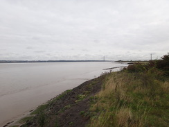
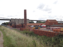
The trail took a more easterly course as it passed Chowder Ness, and from here on the Humber Bridge grew as I approached. The old clay pits to the right had been developed into a series of facilities for the public, including a visitor's centre and a hotel. A little further on was a tile works, one of the many that once dominated the area. It did not look as though it was still active but much work was being done on it, including some re-roofing; a large expanse of newly-laid tarmac made it seem as though the site was being converted to some public use. The boundary wall around the site was made of stacks of beautiful orange-red tiles.
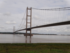
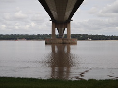
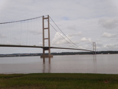
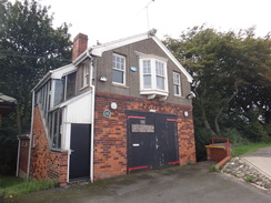
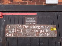
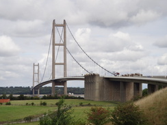
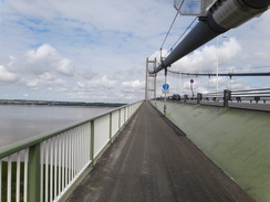
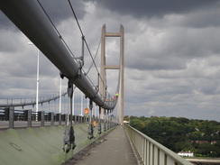
The path took me under the southern end of the Humber Bridge, which was the longest suspension bridge in the world when it opened in 1981. Soon afterwards I reached the end of the Viking Way, which is marked by a sign on a wall on an old coastguard station. My feet were really aching by now but I had only walked about fifteen miles, so I decided to extend the walk by walking over the bridge. First I had to get to the southern end of the bridge, and that involved following a road through the outskirts of the town.
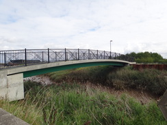
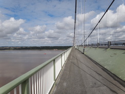
A new visitor's centre sat on the other side of a marshy inlet, and an equally new bridge led over the inlet towards it; these had not been built when I had passed on my coastal walk nine years before, and would have saved me all of a mile's walk. Soon I was climbing up the steps onto the western walkway on the bridge and started the walk over it.
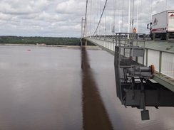
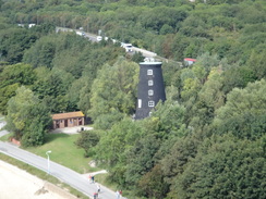
I love engineering of all sorts, and this magnificent bridge was no exception. I studied all the little details, from the way the down cables attached to the bridge deck to the thick lightning conductors that spanned down from the main cables. The views upstream along the river were not particularly noteworthy, aside from a tall windmill stump that stood on the northern bank.
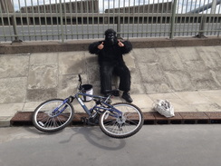
A man dressed in a monkey suit cycled past as I approached the large concrete anchor blocks for the suspension cable. He stopped for a rest by one of the blocks and we chatted for a couple of minutes. He was doing a sponsored cycle ride for charity and I gave him a donation before heading on - it was worth it just for the unusualness of the sight.
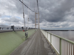
I headed down the steps at the northern end of the bridge and swapped over to the eastern walkway. The views from this were far better, and a cruise ship could be seen berthed in Hull. My mind flashed back to when I had walked over the bridge on my coastal walk; it had been only a few weeks into my year-long stroll and crossing the bridge had felt like a great milestone at the time.
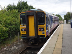
There was one train every couple of hours back to Barnetby, and the next was due soon so I increased my pace, despite my tired feet. I did not take much notice of things after I got off the bridge and concentrated on reaching the station in time. In the end I got there with ten minutes to spare, so I went into a nearby shop to buy some snacks for the journey. I spread my OS maps out on a table on the train and watched the landscape, studying the features as they sped past. I had to swap trains at Harborough, but did not have long to wait before one came to take me back to Barnetby.
It had not been a classic day's walk, and the highlight had undoubtedly been the crossing of the Humber Bridge. I got back to the campsite in the early afternoon and had a decision to make; I had planned to spend an extra night at the campsite before driving home in the morning; however I felt fit and so I decided to pack up and head home. Sadly birds had done their business all over my tent's flysheet, so that will need to be washed as soon as I get back. All in all it had been a good trip, and another good trail - the Viking Way - has been completed. Next (hopefully) comes Scotland...
 |
 |
|
Directions
This walk starts at Barnetby station. Leave the station and head down the station approach until it reaches King's Road, with a railway bridge to the right. Turn left to follow the road northwards for about 0.4 miles as it heads out of the village; there is a pavement on the left. When it reaches a junction with the A18 turn right for a few yards to reach a junction with another branch of the main road. Carefully cross this road to reach its eastern side, and then turn left to head northwards for a short distance to a roundabout over the M180. Head around the eastern side of the roundabout, carefully crossing a sliproad to reach the bridge over the motorway.
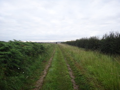
Carefully cross the northern sliproad, and on the other side turn right along a surfaced path that curves to the left away from the sliproad. The path joins a surfaced track that heads northeastwards; after 0.4 miles it crosses Middlegate Lane and continues north-northeastwards across a series of fields. As the track curves to the left, continue straight on along a green lane that slowly starts to curve to the right to head northeastwards. The path finally reaches a road at TA065133 opposite the southern corner of some woodland.
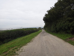
Turn left along this road. When the woodland on the right ends turn left down a gap in the hedge to join a footpath. This heads northwestwards across a series of fields; just keep the hedge to the left. After 1.2 miles the path reaches a road at TA050148; turn left to follow this road northwestwards for a fifth of a mile until the road curves sharply to the left; here turn right and immediately left to join another footpath with a hedge on the left. It heads in a rough west-northwesterly direction for nearly a mile, angling towards the A15 dual carriageway before meeting a track that plunges downhill to end at a road at TA036158.
Cross this road and continue northwestwards for two-thirds of a mile with the dual carriageway on the left. The path curves to the right as it meets a sliproad leading down onto the A15; shortly afterwards squeeze past a set of double gates to meet the sliproad. Turn right up the sliproad as it curves to the left to reach a T-junction. Turn left to cross over the dual carriageway on a bridge and reach a junction with the B1218 on the south side of the road at TA027169.
At the junction turn right to follow the B1218 north-northwestwards for a third of a mile; just after the road curves to the right turn left along a track. As the track immediately curves to the left continue straight on along a green lane towards a vehicle barrier. Do not go through the barrier and instead turn right to walk northwestwards with a hedge on the left. After three-quarters of a mile it curves to the right to take a more northwesterly course for a quarter of a mile until it reaches a road at TA014184.
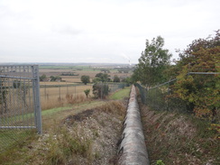
Turn left along the road for 250 yards; shortly after it curves to the right turn right to head northwestwards along a footpath that runs between fields. At the end of this field the path becomes a firm track, initially with a hedge only on the right and then only on the left. When it curves to the left after passing under a set of power lines, turn right along another track that soon curves to the left, passing under a second set of power lines. The track continues northwards for a couple of hundred yards to reach a set of double field gates. Squeeze past these to reach a bend in a road at TA005194.
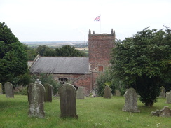
Turn left and follow this road in a rough westerly direction, passing under both sets of power lines once more and large barns on the right before it starts to plunge downhill. After a mile a road junction is reached on the left, here turn right to head northwards along a rough track. This passes under the power lines once more; at the end of the first field it becomes a firmer track that continues on between hedges. The track passes a chalk pit on the right; continue on along the track as it slowly curves to the right to take a more northerly heading, descending to pass South Ferriby church on the left before ending at the A1077 High Street in South Ferriby at SE988210.
Carefully cross the main road and continue on down North End road. As this curves to the left, continue straight on along another track with woodland on the right. When the woodland ends a good track heads on northeastwards. When some old quarry workings are reached at SE995218 ignore paths heading off to the left and the right, and instead head through a flat area of waste ground. When this meets a field, turn left to reach the southern bank of the Humber. At the water's edge turn right to head northeastwards along the narrow boundary between the river on the left and the fields on the right.
After a third of a mile it passes South Ferriby Cliff and joins a good track that follows the coast. Here the route differs from that shown on the 1:25,000 OS map; the floodbank has been purposefully breaches to create saltmarsh. This means that the path curves to the right, heading off the floodbank. It crosses a footbridge over a ditch and curves to the left to head towards South Cliff Farm. As the farm is reached follow the obvious path that turns right and finally left again to pass immediately inland of the farm. Continue past the farm for a few yards to reach Far Ings Lane. This soon curves to the left to head northwards with a lake on the right; when the lane curves to the right to head eastwards between two lakes, continue straight on northwards with another lake on the right.
When a car park is reached beside the foreshore, turn right to head northeastwards along a path for a quarter of a mile; at Chowder Ness the path curves to the right to head eastwards for about 1.2 miles along an obvious track. It passes under the approach viaduct for the Humber Bridge and passes a car park on the right; shortly after this it reaches an old coastguard station on the right, which marks the end of the Viking Way.
Continue on or a few yards to reach the end of the B1218 road in Barton Waterside. Turn right to head this road for nearly a third of a mile until Far Ings Road leads off to the right. Follow this road westwards for a quarter of a mile; immediately after it passes under the approach viaduct to the bridge, turn left down a track that leads to some steps that lead up to the bridge. Once on the bridge turn left to follow the western walkway northwards for 1.7 miles as it crosses the Humber.
After passing the anchor blocks on the northern side of the river, turn left down some steps to reach a track that heads down to a road. Turn left along the road to pass under the bridge, and then immediately turn left to climb up steps back onto the bridge's eastern walkway. Cross the bridge until the steps are reached on the southern side of the bridge; go down these and walk across to Far Ings Road. Turn right and follow Far Ings Road eastwards for a quarter of a mile until it ends at Waterside Road. Turn right and follow the road south for a quarter of a mile; Barton-upon-Humber railway station is soon reached on the left at TA028225.
 |
 |
|
Distances
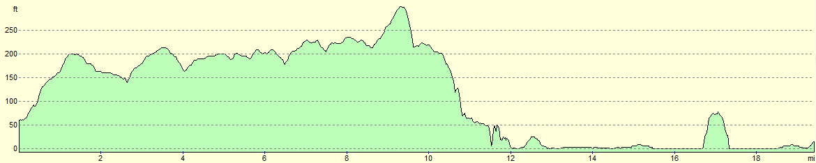
| From | To | Distance (m) | Ascent (ft) | Descent (ft) |
|---|---|---|---|---|
| Barnetby station | B1206 | 6.0 | 299 | 157 |
| B1206 | South Ferriby | 4.8 | 220 | 348 |
| South Ferriby | End of Viking Way | 3.7 | 131 | 207 |
| End of Viking Way | Barton-upon-Humber station via the Humber Bridge | 4.9 | 121 | 105 |
This makes a total distance of 19.4 miles, with 771 feet of ascent and 817 feet of descent.
For more information on profiles, ascents and descents, see this page
Transport
The journey by train from Barton-upon-Humber station to Barnetby is not too difficult; take a train from Barton towards Grimsby, and change at Harborough for one of the many servces that call at Barnetby. See the National Rail website for more information.
 |
 |
|
 |
 |
|
 |
 |
|
 |
 |
|
 |
 |
|
 |
 |
|
 |
 |
|
 |
 |
|
 |
 |
|
 |
 |
|
 |
 |
|
 |
 |
|
 |
 |
|
 |
 |
|
 |
 |
|
 |
 |
|
 |
 |
|
 |
 |
|
Disclaimer
Please note that I take no responsibility for anything that may happen when following these directions. If you intend to follow this route, then please use the relevant maps and check the route out before you go out. As always when walking, use common sense and you should be fine.
If you find any information on any of these routes that is inaccurate, or you wish to add anything, then please email me.
All images on this site are © of the author. Any reproduction, retransmissions, or republication of all or part of any document found on this site is expressly prohibited, unless the author has explicitly granted its prior written consent to so reproduce, retransmit, or republish the material. All other rights reserved.
Although this site includes links providing convenient direct access to other Internet sites, I do not endorse, approve, certify or make warranties or representations as to the accuracy of the information on these sites.
And finally, enjoy your walking!
Nearby walks
| # | Title | Walk length (miles) |
|---|---|---|
| 244 | Paull to Barton-Upon-Humber | 15.7 |
| 245 | Barton-Upon-Humber to Pyewipe | 23.7 |
|
|

|