Walk #244: Paull to Barton-Upon-Humber
 |
 |
|
General Data
| Date Walked | 23/10/2002 |
| County | Humberside |
| Start Location | Paull |
| End Location | Barton-Upon-Humber |
| Start time | 09.20 |
| End time | 16.48 |
| Distance | 15.7 miles |
| Description | This was a fairly uninteresting walk along roads and riverside footpaths to reach the first crossing point of the Humber. The bridge itself, the Humber Bridge, was the literal high point of the walk, and was a very windy but lovely crossing. |
| Pack | Today I carried my 30-litre Karrimor HotRock rucksack, which was filled with my packed lunch, waterproof coat, water bottle and a couple of spare shirts, together with the usual assortment of odds and ends. |
| Condition | My feet are slightly sore after this walk, which is probably a result of the long sections of road walking that I had to do. Aside from this I am fine, with no problems to report. |
| Weather | The main feature of today's weather was the wind, which was a very strong westerly all day. This was less noticeable in the built up areas, but on the riverbank and bridge some of the gusts were fairly fierce. There was a little rain in the wind when I crossed the bridge, but this was the full extent of the rain and it was not enough to cause me to put my hood up. |
| OS map | Landranger number 107 (Kingston upon Hull & surrounding area) |
 |
 |
|
 |
 |
|
Map of the walk
Maps courtesy of Google Maps. Route for indicative purposes only, and may have been plotted after the walk. Please let me have comments on what you think of this new format. For a detailed table of timings for this walk, please see the table file.
Notes
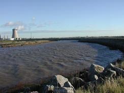
The wind that greeted me in Paull when I gout out of the van was manageable, but after I had walked a short distance past the shipyard to where the flood defences began it was really noticeable. Wind like this can make walking quite difficult at times, particularly when it gusts, and this was not helped by the fact that the BP chemical plant across the Hedon Haven was placing some noxious odours into the air.
When I got to Kingston upon Hull I diverted inland into the city centre to try and find myself an internet cafe. I found one just down the road from the tourist information office, but it cost an extortionate two pounds for fifteen minutes! I was still half expecting a phone call from Radio Humberside, so after checking my emails I went to a pub and had a pint. When I had not had a call after half an hour I decided that I had to press on, which was a shame,
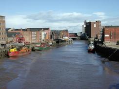
Hull itself is a surprisingly nice place (at least the areas that I saw of it were), and it is very much built around it's water heritage. The main shopping centre, the Princes Quay, is at the end of Hull Marina and is a quite imposing building. Before getting into the very centre of the town I passed The Deep, a large and modern aquarium which had some very long queues of people waiting to get in. All in all Hull gave off the air of a city that was trying to reinvent itself from its industrial past - and succeeding.
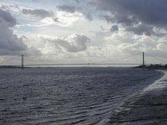
The highlight of the day was definitely the Humber Bridge, which for many years was the longest suspension bridge in the world. There was quite a wind coming from my right as I crossed it, and it caused me to wobble on occasion near the middle of the span. After I had passed the southern tower I saw Sam coming towards me, and when we met I paused so that she could take some photos of me before we continued on together towards the campsite. I had been planning to walk further today, but it was starting to get late and I did not really want to have to force Sam to move the caravan unnecessarily, so I decided to finish the walk at the van.
There are two Dutch cyclists who are staying in the site who are over in England for a week's cycling holiday. Last night they went to a pub up the road and they came back to find that their bike's have been stolen. When Sam arrived at the site the site owner told her that Radio Humberside had interviewed them, and this evening we found out that a local pub has bought them two new bikes to replace those that were stolen. This is a lovely, heart-warming story, although it is slightly spoilt by the fact that the bikes were stolen in the first place.
Tomorrow I should be able to reach Immingham or maybe even Grimsby if I do a long walk, and this means that I will have finished the Humber estuary section of the walk and it will then simply be a case of walking south for a couple of days to get to the wash. I am now nearing territory where I have walked before, and am feeling quite happy about being able to walk long distances each day.
Directions
This walk starts off at the post office outside Paull, to the southeast of Kingston upon Hull. Walk north along the road out of the village, passing a small shipyard on the way. Immediately beyond the shipyard turn left and follow a footpath that runs along the top of the seawall. The path twists and turns as it joins the eastern side of the Hedon Haven.
when the path ends at a road turn left along the road, crossing over Hedon Haven by a bridge. Continue along this road as it heads to the northwest until it ends at a roundabout with the A1033(T). At the roundabout turn left and follow the A1033(T) as it heads westwards for a couple of miles. The road passes under a railway bridge and at the next roundabout turn left down to a second roundabout. At this roundabout turn second right to head south along a road through the docks.
Just before the road curves around to the left turn right and enter a car park. Walk through the car park and exit it along a footpath that leads to a bridge over the Holderness Drain. On the other side of the bridge the path follows the seawall westwards around the docks.
The path crosses over the entrance to another dock by means of the dock gates before continuing on to enter Victoria Dock Village. The path continues on following the seawall until it ends when it reaches the distinctive building that houses 'The Deep' aquarium.
Turn right immediately before you reach the aquarium and follow the road that leads through the car parks towards the A63(T) road. There is a new footbridge that is under construction and which is due to open in the autumn; this may well cause you to alter the route that I describe here. Cross under the A63(T) bridge and then climb up the spiral ramp that leads up to the A63(T). At the top turn right and follow the pavement beside the main road over the River Hull and down the other side. Continue on along the A63 road as it heads westwards and becomes Castle Street. Pass the end of the marina and once on the other side turn left to a bridge over the mouth of a dock.
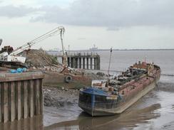
From the marina pass the Spurn Lightship and follow the road as it skirts the seafront and reaches the entrance to the Associated British Ports. Turn left and enter the port; the way is well marked on the ground and lead to a set of lock gates. Cross over the gates and then climb up some steps that lead up to a walkway that runs at the top of a warehouse beside the riverfront.
Follow the walkway along the top of the warehouse and then descend down steps on the other side. The path then passes between the seafront to the left and the docks to the right, with a large fence in between them. A series of buildings are met on the right before the path meets the St Andrew dock gates.
Cross the gates and follow the path onwards as it heads to the southwest. The areas of the docks have now been replaced with a retail park that includes a multi-screen cinema. Fairly soon the retail park ends and scrubland appears on the right until the end of St Andrews Quay is reached.
The path turns to the right to head inland towards the A63(T) before turning to the left to run alongside and slightly below the main road. After about a mile the path curves around a roundabout beside the road and then climbs up some steps to the right that leads to a slip road running from the roundabout to the main road. Turn left down the slip road and then turn left down Livingstone Road.
Follow Livingstone Road as it heads westwards to Hessle Haven. Here it turns sharply to the left beside the haven and then to the right. At the right turn continue straight on down a footpath that meets the river front once more. Head west along this path towards the Humber Bridge.
Before you get to the bridge turn right down a footpath that runs between some trees to the left and a wooden fence to the right; this path climbs some steps before ending at Livingstone Road where it passes over the A63(T). Join the road and continue straight on northwards and then turn left down a close, following the national cycle route 1signs. The road ends and a path continues on, passing under the approach roads to the Humber Bridge and turning around through an area of parkland before reaching some steps that lead up to the bridge.
Climb the steps and turn right to cross over the River Humber. On the other side climb down steps that lead to a road, and then turn right along this road and pass under the bridge and follow it eastwards until it ends at a main road in Barton-upon-Humber. The campsite where we stayed is about fifty yards down the road to the left.
Distances
| From | To | Distance (m) | Ascent (ft) | Descent (ft) |
|---|---|---|---|---|
| Paull | Kingston Upon Hull | 7.6 | 66 | 66 |
| Kingston Upon Hull | Barton-Upon-Humber | 7.8 | 82 | 82 |
This makes a total distance of 15.7 miles, with 148 feet of ascent and 148 feet of descent.
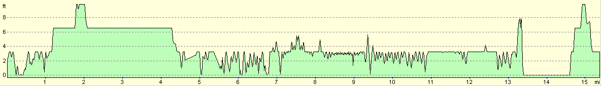
For more information on profiles, ascents and descents, see this page
Accommodation
We stayed at the Silver Birches Tourist Park, Waterside Road, Barton upon Humber, DN15 5BA, Tel. 01652 632509. This site cost us 1.50 for the night as they gave us the site pitch for free and charged us for electric, which as exceedingly kind of them.
Disclaimer
Please note that I take no responsibility for anything that may happen when following these directions. If you intend to follow this route, then please use the relevant maps and check the route out before you go out. As always when walking, use common sense and you should be fine.
If you find any information on any of these routes that is inaccurate, or you wish to add anything, then please email me.
All images on this site are © of the author. Any reproduction, retransmissions, or republication of all or part of any document found on this site is expressly prohibited, unless the author has explicitly granted its prior written consent to so reproduce, retransmit, or republish the material. All other rights reserved.
Although this site includes links providing convenient direct access to other Internet sites, I do not endorse, approve, certify or make warranties or representations as to the accuracy of the information on these sites.
And finally, enjoy your walking!
This walk was mentioned in the following routes:
| My walk around the coastline of Britain |
Nearby walks
| # | Title | Walk length (miles) |
|---|---|---|
| 243 | Skeffling to Paull | 18.9 |
| 245 | Barton-Upon-Humber to Pyewipe | 23.7 |
|
|

|