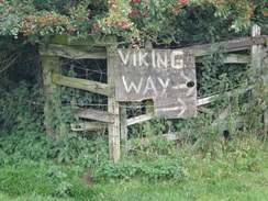
Walk #919: Viking Way: Market Rasen to Tealby and Barnetby le Wold
 |
 |
|
General Data
| Date Walked | 30/08/2011 |
| County | Lincolnshire, Humberside |
| Start Location | Market Rasen |
| End Location | Barnetby station |
| Start time | 07.39 |
| End time | 16.24 |
| Distance | 21.9 miles |
| Description | This was a very enjoyable walk, following the Viking Way northwards through Lincolsnhire, with a little diversion off to visit the Lincolnshire county top. |
| Pack | Today I carried my 30-litre Karrimor rucksack, filled with water, my waterproofs, a couple of books and other odds and ends. |
| Condition | I feel relatively okay after this walk, except for the underside of my feet which really ached by the end of the day. |
| Weather | Today's weather was dominated by high, thin cloud, and the sun often burst through. The wind was nowhere near as fierce as it was yesterday, but was strong enough to keep me cool. |
| OS map | Landranger number 113 (Grimsby, Louth & Market Rasen) and Landranger number 112 (Scunthorpe & Gainsborough) |
 |
 |
|
Map of the walk
Maps courtesy of Google Maps. Route for indicative purposes only, and may have been plotted after the walk. Please let me have comments on what you think of this new format. For a detailed table of timings for this walk, please see the table file.
 |
 |
|
Notes
I felt relatively fine after yesterdays stroll and woke refreshed and ready for another walk. I had had a good nights sleep despite a large jet plane flying over very low at about ten oclock; the roar seemed to ever increase to a crescendo and the navigation lights illuminated my tent. Condensation had formed in my tent once more - not too bad as I was car camping and could dry a few things out in the car during the day. A couple of people were out and about around the campsite as I started the drive north to Barnetby station.
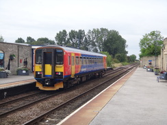
My walks was to start in Market Rasen and end at Barnetby, so I decided to drive to the endpoint so that I could catch an early train down to Market Rasen. It proved difficult to find somewhere to park at Barnetby station; initially I tried a little car park beside the station but had a bad feeling about it - in the end it turned out to be a staff car park, so I parked on the roadside instead.
I chatted to an exceedingly jovial man on the station platform; he was an engineer working in Lincoln, and had one of the heartiest laughs that I had heard in a long time. It was a feature that he used to full effect as we talked, and he left me feeling exceedingly happy.
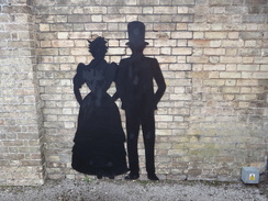
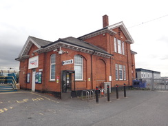
The train dropped me off at Market Rasen station, which was quite well looked after. Silhouettes of people in period costumes had been placed against the walls, and there was even a poets corner. It was certainly an improvement on the soulless Barnetby station, which was dominated by a bleak and oversized footbridge.
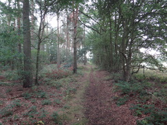
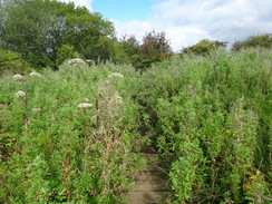
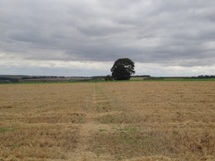
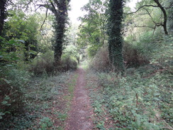
I had hoped to nip into a shop in Market Rasen to buy some provisions for the day, but I did not pass any and was soon heading along a footpath out of the town. My initial target was to join the Viking Way where I had left it the previous day in Tealby; unfortunately this involved a three-mile walk from the town. A good footpath took me to a large area of woodland, which eventually dropped me out onto the Rasen Road. Google Maps had showed a pavement alongside the road, and this turned out to be little more than a gravel path in places.
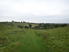
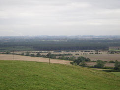
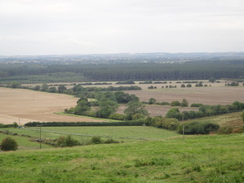
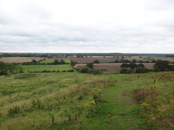
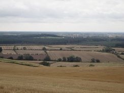
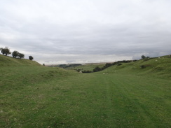
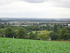
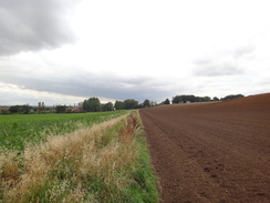
Tealby had enchanted me yesterday, and sadly I did not get to see much of it today as I joined the trail on the western outskirts of the village proper. This prevented me from seeing the glorious church or visit the well-stocked community shop that proved too much of a diversion so early in the day. A good footpath took me up across fields, soon descending and climbing onto the top of a hill. It proved to be an energetic but rewarding stroll, with some grand views over the plains to the west; a couple of power stations were visible in the distance, and Scunthorpe steelworks was on the horizon.
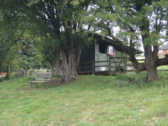
A few signs about sheep came into view as I approached Risby Manor Farm. Another sign pointed through a gate towards a large wooden hut. This proved to be a well-stocked honesty shop, with (amongst other things) bags of wool from their sheep for sale. There was not really room in my pack for a bag of wool, but I did buy a tub of ice cream, leaving the money in the honesty box. Unfortunately as I walked on I remembered that I didnt have a spoon to eat it with.
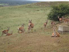
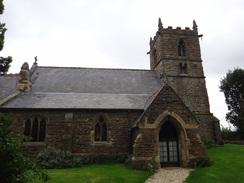
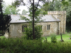
A steep descent - perhaps the steepest on the Viking Way so far - took me down to a stream and through a large gate into a deer enclosure. A score of deer were standing nearby and they remained motionless as I strolled nearby - they are evidently used to people. A similar steep ascent led me out of the deer park and to the exquisite Walesby Hall church, situated on a hill above the village. A note on a board stated that, after a recent theft, the lead on the roof had been replaced with an alternative and worthless material. Yet again I found my ire rising against the scrap-metal thieves that seem to be plaguing us now that scrap metal prices are sky-high.
A long descent down a track took me down into Walesby, which seemed plain and uninteresting after the beautiful Tealby. Soon a track took me back uphill, the exertion being rewarded with splendid views over the plains to the west. In the distance I saw five thin streams of smoke winding through the air. Yesterday I believed that I had seen smoke trails from the Red Arrows, barely discernable in the distance. Todays clearer view left me in no doubt - particularly due to the red and blue colours that hung in the smoke stream. As they are based at nearby RAF Scampton, it seems fairly likely that they were indeed the Red Arrows.
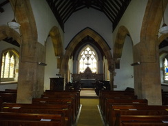
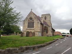
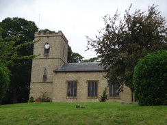
The next stretch of path was particularly enjoyable. The harsh winds of yesterday had subsided to little more than a chilly breeze and the views to the left were utterly uplifting. Unfortunately they had to end, and they did so in the form of the delightful Normanby le Wold church. Situated on the top of a hill, the church seemed far too large for such a small hamlet. Fortunately it was open and I spent a few minutes exploring the interior.
The road out of the village was blocked by a farm digger, an elderly farmer standing in the raised front bucket as he cut branches off an overhanging tree. He was shouting instructions to his wife at the controls in an operation that looked as much rural as it was precarious. A little further on I had a decision to make - five years before I had walked from Newark to Market Rasen in order to visit Lincolnshires highest point, which is just to the north of the village. I had never extended the walk to visit the top, but todays route would be going just a few miles away and I wondered if I should visit it.
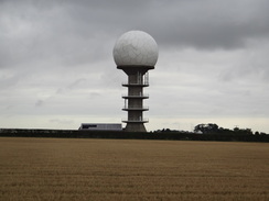
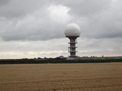
In the end I decided to do it and I diverted off the trail, heading down a road towards a structure that seemed like a golf ball standing proudly on top of a tee. It was obviously a radar system, and further research shows it to be the National Air Traffic Control radar installation. A small wooden cross sat on the verge beside the road, inscribed with only the cryptic NG269. Given its location I assumed it was a memorial to a crashed airplane, and later research showed it to refer to a Lancaster that crashed on the wold in 1946, sadly killing four of its seven crew.
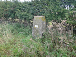
Next I had to cut across a field of recently-cut corn, the low stalks brushing against my legs. Naturally enough the trig pillar that marks the Wolds Top was on the other side of the hedge and I had to cross into the next field to reach it.
The pillar itself was buried inside a hedge, and sadly the views were not particularly good due to the flat nature of the summit. The plains were visible to the northwest, but there was little else to see of any note. Instead of hanging around I re-entered the corn field and headed back to the road. A tractor was making its way through the next field to the left and I hurried away, not wanting to get caught trespassing.
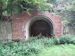
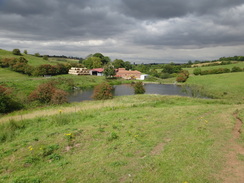
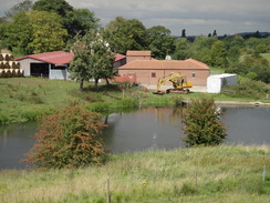
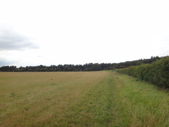
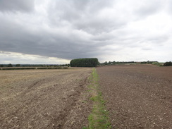
A long road walk took me north to Acre House, and the superb views to the left caused me to slow down so that they could sink in. A path then led through a long valley northwards. This was not a bad walk, but I wondered why they did not take the trail over Nettleton Top to the west; it would have involved more road walking but also would have allowed superior views. Instead this stretch of path proved to be fairly boring and never seemed to end. The only thing of interest were some brick arches built into the hillside above a lake; they looked a little like lime kilns, but I could see no hole in the top and they were also quite shallow. Although they were obviously industrial in purpose, I have absolutely no idea what they were. Later research shows that they were the entrance to old ironstone mine workings that had been bricked up. The mine had shut in 1968, and it was surprising how well vegetation had reclaimed the site.
I met a young man as I entered Nettleton. He had set out to do his first walk, following a print-out from a guidebook. His nervousness was obvious and I gave him some words of encouragement before we parted. I did not get to see much of Nettleton, but I liked what I saw. The stone had altered over the last few miles, the stone here being a rosy ironstone that gave the buildings a healthy glow. A rather bitty path then led on to the outskirts of Caistor.
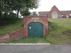
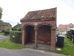
A little alcove in a bank in the town was marked as being an old fire station, which was fed with water from an adjacent spring. I stopped to take a photo and a man did the same; we both walked up the hill and started chatting before stopping at the bustling community cafe. This was part of the Caistor Arts and Heritage Centre, which had recently been featured on a TV program called Village SOS. Perhaps that was the reason it was so popular, or perhaps it was the high quality of the food - far better than is usually served in a cafe.
We both sat down at the only available table and continued to chat as we awaited our food. It turned out that the gentleman was surveying the buildings in the area, checking that the character of the area was not being spoilt by development. Our rather eclectic conversation took in planning laws, architecture, roman history, farming and mountains and I left feeling much happier, having had both my mind and my body fed.
I had walked around Caistor the previous evening and had not been particularly impressed; now, however, I was in a much more appreciative mood. A steep path took me down into a valley and up the other side before finally descending once more to reach Hundon Manor. The trail kept more or less to the low ground from here on, with the high ground stretching up to the right. It crossed the main road by the tiny hidden church at Clixby before reaching Grasby.
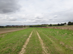
My feet were starting to ache by now and I wanted another little rest, but the picturesque church proved to be locked. Instead I plodded on, my aching feet removing some of the joy that I should have been getting. Searby and Somerby were soon passed, the -by endings of the name pointing to Viking origins. The trail recrossed the main road in Bigby and turned to take a more northerly course, heading across fields towards Barnetby-le-Wold. The going was thankfully flat and it was a relief when the railway line came into view in the distance.
A woman was walking five black Labradors along the path. They were proving a handful and she had to stop every few yards to swap leads between hands as the dogs criss-crossed in front of her. Her troubles seemed to make my task less onerous and I sped up for the last half-mile. Eventually I met the road near the station and nipped into a shop before making my way to my car.
It had been a good days walk, and there was only about fourteen miles to do tomorrow to reach the end of the trail on the Humber. However I was slightly concerned about the way my feet were aching; it was not a good sign after what had been a not particularly strenuous stroll. I drove back to Caistor to try and find somewhere to eat; the only obviously good restaurant did not start serving food until seven, so I phoned a friend who knew the town only to find that good eateries are distinctly sparse. In the end I went into the White Hart and had a rather filling meal before going back to my tent for some sleep.
 |
 |
|
Directions
This walk starts off at Market Rasen railway station. Leave the station and head down the station approach until it ends at a T-junction with Chapel Street. Turn right and immediately pass under a railway bridge; the road soon ends at a T-junction with the B1202. Turn left to follow this road northwards; when it meets a traffic-light controlled crossroads with the A631 carefully cross the road and continue straight on along Jameson Bridge Street.
Jameson Bridge Street crosses a bridge over a stream. Shortly after Waterloo Street comes in from the left, turn right down a surfaced track that carries a pubic footpath. This leads into a car park; at the end of the car park join a narrow footpath that runs between a hut to the right and a hedge to the left. The footpath soon curves to the left to reach the end of Old Dairy Road. Turn right past the end of the road and continue eastwards along a path, with a hedge on the left and a fence on the right. This eventually crosses a stile to enter a field. Head straight across this field to reach a footbridge that leads into some woodland.
Follow a good path that heads east-northeastwards through the woodland; the path is flat and easy to follow, and for much of the way it follows power lines immediately to the left. A mile after entering the woodland the path emerges from the trees to meet Rasen Road at TF136903. Head straight on eastwards along this road for 1.3 miles as it enters the village of Tealby; there is a pavement on the left for most of the way. At TF155908, just before the road reaches the church, turn left along a driveway.
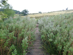
This passes a double garage on the right and climbs up a slight slope to reach a clappergate beside a field gate. Go through this to enter a field. Flank the hillside northwestwards; the path is well waymarked as it curves to the left to descend to meet a fence and hedge on the left. Continue on to a clappergate through a fence and head on with a hedge on the left. At the end of this field the path crosses a boardwalk over boggy ground. Ignore a footpath leading off to the left and continue on along the boardwalk.
When the boardwalk ends keep the fence on the left; at the end of this field go through a gap in the fence and continue on uphill along a track. As it approaches a copse called Bedlam Plantation on the right, the path curves to the left slightly to continue ascending. It reaches the top of the hill and goes through a clappergate with a barn on the left. The path heads through the edge of the trees with a fence on the left. The path climbs, going through a pedestrian gate and finally leaves the woodland via a second.
As the path leaves the woodland it turns slightly to the left, heading downhill past a pond on the left, aiming for a clappergate at the bottom left-hand corner of the field. Go through this and continue on with a fence on the right.
Go through a clappergate and cross a surfaced track (the approach driveway to Risby Manor Farm) to reach a second clappergate. Keep a fence on the right; when it curves sharply to the right continue straight on across the field, still climbing slightly towards a hedge on the right. Follow the hedge as it plunges steeply downhill to reach a gate. Go through this and cross a footbridge over a stream to reach a tall deer gate.
Keep a tall fence on the right as the path climbs; leave the fence near the top and turn half-left to angle through some scrubland, aiming for the upper left-hand corner of the field. Go through another tall deer gate and cross a track to enter a field, aiming immediately to the right of the tower of Walesby Hall Church. The path goes through a metal gate and continues on with a fence to the right as it heads slightly downhill, aiming for a wooden gate that leads into the churchyard.
Angle half-left downhill through the churchyard, passing the tower on the right to reach a set of double gates. Go through these to join a green track that runs between hedges, curving to the left to head westwards into the village of Walesby. The track meets a bend in Rasen Road at TF134923; turn right down this road and then take the first road to the left, Walesby Hill Road.
Follow Walesby Hill west through the village; when a junction is met continue straight on westwards along Moor Road. After a quarter of a mile turn right up a track that runs northwards between hedges. When the track forks after a couple of hundred yards, take the left-hand branch which heads diagonally across a field between fences. It then crosses a cattle grid and curves to the right to head northwards uphill across a field with a hedge on the left.
Go through a field gate and continue on uphill along the track. When the hedge curves away to the left continue along a path that climbs slightly, keeping to the left of a small hill. The path passes the hill then follows a small escarpment on the left, always climbing. At the top left-hand corner of the field turn left through a pedestrian gate into another field. Follow a hedge on the right; the path slowly climbs with expansive views to the left.
Keep the edge of the field to the right; the path curves to take a more northerly course along the crest of the hill, with Claxby Wood some distance away on the left. It heads through a metal pedestrian gate to enter another field. At the end of this field cross a stile and continue on with the hedge still on the right. It eventually crosses another stile to join a track that continues northwards towards Normanby le Wold church. The track becomes surfaced and curves to the right and then the left as it passes the church.
Follow this road northwards for a fifth of a mile until a road junction is reached at TF122950, with a phone box immediately ahead. Turn left to follow this new road westwards; immediately before it plunges downhill turn right through a clapper gate to join a footpath. This heads northwestwards for about 250 yards with a hedge on the right; it descends down the field to reach another clapper gate that leads onto a road.
Turn right and start following this road northwards. When a road junction is reached after a fifth of a mile at TF119955 I decided to head off to visit Lincolnshires highest point; this is an optional extra that involved trespass. To do this I left the trail and turned right to head northeastwards along a road. This passes a road junction on the right and continues on; after a quarter of a mile turn left through a gate to gain access to a field. Keep a hedge on the left along this field, and when it ends turn right. When a gap in the hedge is reached go through it and turn right, keeping the hedge on the right until a trig pillar buried inside the hedge is reached at TF121964; this is the highest point of the county. From there retrace your steps back to the road junction where you left the trail.
From the road junction at TF119955 continue straight on for another 0.9 miles north-northwestwards along the road, with grand views to the left. Immediately after a farm near Acre House is reached on the left, turn right through a metal gate. This leads onto a track that immediately skirts the base of a telecoms mast on the left. This track heads eastwards with a hedge on the right; shortly after it curves to the right go through a metal bridleway gate and turn left to head northeastwards down a dry valley.
Head towards a metal pedestrian gate at the bottom of the field; on the other side of this cross a boardwalk to reach a second pedestrian gate. Continue on down a field with a fence on the left, near to a stream called Nettleton Beck. The path and fence curve to the left to approach some woodland. When the trees are reached go through two gates to enter the trees. The path climbs up some steps past some brick arches in the hillside (the remains of an old ironstone mine). At the top of the steps turn left to follow a path past more archways to join a track. This curves to the right as it heads uphill, emerging from the trees.
At the top it joins a concrete track; turn left down this to head westwards along this track for a few yards, and before the bottom of the hill is reached turn right through a metal gate to join a footpath. This heads northwards with a fence and the Nettleton Beck a short way on the left. It crosses a small causey and reaches a metal pedestrian gate to reach another causey. Cross this and go through another pedestrian gate, still with a fence on the left.
The path crosses a footbridge over a ditch and then climbs slightly before descending to pass a pond on the left. Go through a gap in the hedge ahead to reach a track at TF116994. Turn left along this track; it immediately crosses a ladder-stile beside a gate. On the other side it immediately curves to the right, passing Nettleton Grange on the left and ending at a T-junction with another road. Turn right along this road and follow it northwards for a third of a mile until Mansgate Hill road leads off to the right in Nettleton at TA111001.
Follow Mansgate Hill road as it curves northeastwards. As the road curves to the right after 250 yards, turn left up a surfaced driveway and then immediately right through a clappergate into a field. Turn left to head north diagonally across this field, initially with a fence on the left; when the opposite corner of the field is reached, go through a wooden clappergate and turn right into the next field. Keep the hedge to the left across another three fields separated by clappergates; as the fields are crossed the path and hedge curves to take a more northeasterly course.
After crossing the hedge out of the third field, head straight on to meet a hedge on the right. Keep it on the right as it crosses hedges into two fields. The third field is rather short; the path climbs a steep concrete slope to reach the A46 Caistor Bypass. Carefully cross this and on the other side descend another concrete path. At the bottom the path curves sharply to the right to run between fences with houses on the left. The path soon curves to the left and then left again for about five yards to reach the end of Westwold Road. At the road turn right down the dead-end road and then right once more; when the road ends take a surfaced path that kinks left and the right to run with a fence on the left and hedge on the right; it soon ends at Nettleton Road in Caistor.
Turn right and follow Nettleton Road as it curves to the left to head northwards uphill, becoming Horse Market and then Plough Hill as it reaches the centre of the town. Head across the market place and continue on to reach the A1084 in Caistor at TA118013.
Turn left to follow the A1084 westwards for about 150 yards before turning right down a narrow footpath with a house on the right and a wall on the left. The path crosses North Street and continues on, initially with houses on the right before running steeply downhill between hedges. At the bottom it crosses a footbridge over a stream and climbs uphill with a hedge on the right. At the top go through a clappergate to reach a track, cross this and go through another clappergate to continue slightly west of northwards across a field. Go through a clappergate at the end of this long field and head on downhill, angling away from the fence on the right to reach a stile beside a double field gate. Cross the stile to reach a surfaced track at Hundon Manor at TA115024.
Cross the track and go through a clappergate into a small paddock. After fifteen yards cross a stile over a fence and continue on for twenty yards to another clappergate with a pond to the left. Go through the clappergate and on the other side cross a plank bridge and a stile. After this follow the path as it curves to the right, angling across the middle of a field
At the far side of the field it crosses a footbridge over a ditch and then a stile; continue on with a hedge on the left. The path passes under some high-tension power lines; just before the end of the field turn left across a stile and then right to reach a stile in the hedge on the right. Continue straight on with a hedge on the left as the path heads towards Fomaby House Farm. When it reaches a fence before the farm, turn left keeping the fence and the farm on the right.
When the fence ends with a gate on the left, cross a stile beside the gate and turn right, keeping a fence and the farmhouse on the right. After about thirty yards turn right through a wooden clappergate and continue on with a fence on the right for about ten yards to another clappergate. Go through this and continue on, still with a fence on the right. The path soon ends at the driveway to the farm at TA111030.
turn left to head west down the track away from the farm, and then turn right through a clappergate to join another track. This passes a house on the right. As the main track curves to the right into the house, a footpath continues straight on along a grassy track, following a hedge on the right. At the end of this field go through a clappergate that leads into an area of woodland. The path curves slightly to the left as it heads through the trees. It goes through a gate to emerge out into a field on the northern side of the trees. Follow a slight track northwards between two fields; it soon reaches a surfaced track to the west of Audleby.
Cross the track and continue straight on along another path that immediately passes the end of a lake on the left. Continue on with a fence on the right past a house on the left. As it passes the house, the path curves to the left to meet a hedge guarding the house. The path then curves to the left to head northwestwards across another field with a fence on the right. When a hedge is reached ahead, turn left down a slight slope with the hedge on the right for about thirty yards, then turn right through a gap in the hedge. Follow a path that heads between two fields; this eventually meets a field boundary on the left. As the boundary to the right, turn left to cross a stile and then head diagonally across a paddock, aiming for the main road. Cross a stile beside a field gate to reach the A1084 road in Clixby opposite Church Farm.
Turn right and carefully follow the road northwestwards for a few yards, then as the road swings to the right, turn left down a surfaced track that leads towards Clixby Manor Farm. When the track curves to the left at the far side of the farm, continue straight on along a footpath between fields, aiming for the right-hand edge of some woodland ahead. It skirts the woodland and continues on across another field in a west-northwesterly direction. Squeeze through a hedge and continue on across the next field; soon a hedge is joined on the left. Follow this hedge; squeeze past a wooden field gate into another field and continue on between hedges. The path becomes a surfaced track called Clixby Lane, with houses to the right.
When Clixby Lane ends at a T-junction, turn left along Vicarage Lane. As this curves to the left turn right, passing the church on the left. Continue along the road westwards; when it ends a surfaced lane runs on between fields. Half a mile after the church a wooden gate leads onto a road below Owmby Hill at TA078050. Cross the road and go through a wooden gate to follow a path with a fence on the left and a hedge on the right. This leads to another wooden gate; about ten yards further on there is a third gate. Continue on with a fence on the left; it goes through a pedestrian gate and heads through woodland. It goes through a clappergate and heads on with a hedge on the left. This path leads to a clappergate that in turn leads to a track that ends at a road in Searby directly opposite the church.
Turn left along the road for a few yards past the church, and then turn right up Back Lane. Shortly after this curves to the left, turn right over a plank bride over a ditch and then through a pedestrian gate to enter a field. Head northwestwards across a field, skirting a fence for a short distance before reaching the corner of the field. Go through a metal gate and head northwestwards with a hedge on the right. Cross a clapergate into another field and continue with the hedge on the right. Shortly after passing Grange Farm on the left, the path goes through a pedestrian gate and continues on across an area of scrubland to reach a clappergate. Go through this and turn right to join a surfaced track that continues straight on to reach a road at TA064065.
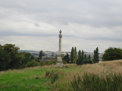
The road curves to the left shortly after passing a church on the left; just before the apex of the bend turn right through a clappergate to enter a field. Head northwestwards across the field, passing the Somerby Monument on the left. Go through a pedestrian gate and cross a plank bridge to reach another pedestrian gate. The path slowly curves to the right to reach a clappergate that leads out onto the A1084 road immediately to the south of Bigby. Carefully cross the road and follow Main Street northwards through Bigby.
After 300 yards turn left along Smithy Lane, which soon curves to the right and then the left, becoming a footpath with a fence on the right. The path curves to the right once more, following a ditch on the right. At the end of this field the path turns to the right to cross a bridge over a ditch, and then immediately left to cross a bridge over another ditch. On the other side continue on with a hedge on the left. This meets a track; turn left down this track for about ten yards and then turn right down another track that runs northwards between fields.
At the end of the field the path curves to the right for about ten yards and then the left to continue between two fields. At the end of this field, cross a footbridge over a large ditch and on the other side turn left and then immediately right to head straight on, again between fields. Eventually it follows hedges towards the outskirts of Barnetby-le-Wold.
The path becomes a track that ends at Marsh Lane to the south of Barnetby le Wold. Turn left to head west-northwestwards along Marsh Lane for nearly a quarter of a mile and then turn right up a green track that runs between fields. Follow the track northeastwards for a third of a mile across a couple of fields until it meets another track at Low Farm; turn left to continue northeastwards, keeping the farm on the right. This track ends at St Marys Avenue in the village; turn left along this road and follow it as it curves to the right to end at Victoria Road. Turn left to follow Victoria Road west-northwestwards; it soon curves to the right to head under a bridge under a railway line at TA054099; Barnetby station is along the first road to the left.
 |
 |
|
Distances
| From | To | Distance (m) | Ascent (ft) | Descent (ft) |
|---|---|---|---|---|
| Market Rasen station | Tealby | 3.5 | 187 | 36 |
| Tealby | Normanby le Wold | 4.0 | 627 | 407 |
| Normanby le Wold | Caistor | 6.3 | 390 | 558 |
| Caistor | Barnetby station | 8.1 | 387 | 630 |
This makes a total distance of 21.9 miles, with 1591 feet of ascent and 1631 feet of descent.
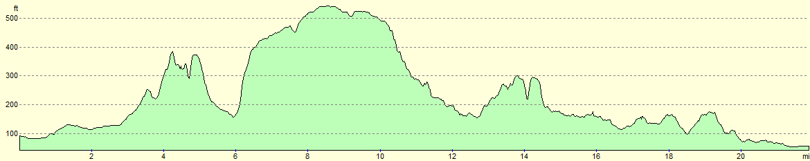
For more information on profiles, ascents and descents, see this page
Transport
Regular railway services run between Barnetby and Market Rasen; see the National Rail website for more information.
Accommodation
I spent the night at the Caistor Fisheries campsite, situated about a mile to the north of the town. This had good, basic facilities and cost only eleven pounds for the night.
 |
 |
|
 |
 |
|
 |
 |
|
 |
 |
|
 |
 |
|
 |
 |
|
 |
 |
|
 |
 |
|
 |
 |
|
 |
 |
|
 |
 |
|
 |
 |
|
 |
 |
|
 |
 |
|
 |
 |
|
 |
 |
|
 |
 |
|
 |
 |
|
 |
 |
|
 |
 |
|
 |
 |
|
Disclaimer
Please note that I take no responsibility for anything that may happen when following these directions. If you intend to follow this route, then please use the relevant maps and check the route out before you go out. As always when walking, use common sense and you should be fine.
If you find any information on any of these routes that is inaccurate, or you wish to add anything, then please email me.
All images on this site are © of the author. Any reproduction, retransmissions, or republication of all or part of any document found on this site is expressly prohibited, unless the author has explicitly granted its prior written consent to so reproduce, retransmit, or republish the material. All other rights reserved.
Although this site includes links providing convenient direct access to other Internet sites, I do not endorse, approve, certify or make warranties or representations as to the accuracy of the information on these sites.
And finally, enjoy your walking!
Nearby walks
| # | Title | Walk length (miles) |
|---|---|---|
| 608 | Market Rasen to Lincoln | 24.1 |
| 918 | Viking Way: Donington on Bain to Tealby and back | 22.0 |
|
|

|