Walk #608: Market Rasen to Lincoln
 |
 |
|
General Data
| Date Walked | 15/05/2004 |
| County | Lincolnshire |
| Start Location | Market Rasen |
| End Location | Lincoln |
| Start time | 08.45 |
| End time | 16.33 |
| Distance | 24.1 miles |
| Description | This was a flat and fairly boring walk, winding its way southwestwards towards Lincoln. Any walk that ends by passing Lincoln Cathedral cannot be too bad, however. |
| Pack | Today I carried my 30-litre Karrimor HotRock rucksack, which was filled with my waterproof leggings, water bottle, trainers and a couple of spare shirts, together with the usual assortment of odds and ends. It weighed slightly more than usual as I also carried a couple of litres of extra water. |
| Condition | I am quite tired after this walk, and have a couple of blisters on the outside of my feet, which is somewhere that I have never had blisters before. I could not have walked much further in any circumstances; I was exceedingly glad when I reached the end. |
| Weather | The morning started off quite cloudy, but as the day went on the clouds lifted revealing glorious sunshine, It must have been one of the hottest days of the year so far, and there was not much of a breeze to keep me cool. |
| OS map | Landranger number 121 (Lincoln & Newark-on-Trent) |
 |
 |
|
 |
 |
|
Map of the walk
Maps courtesy of Google Maps. Route for indicative purposes only, and may have been plotted after the walk. Please let me have comments on what you think of this new format. For a detailed table of timings for this walk, please see the table file.
Notes
This was a walk that I was really not looking forward to; in its most direct form it was to be a twenty mile flat stroll through Lincolnshire, mainly along roads. I needed to do the walk to connect my walk to Lincoln a month ago to Lincolnshire's highest point, which is a short distance to the north of Market Rasen. Because the walk looked like being boring I decided to spice it up a little, by making the route less direct and visiting four trig points on the way. This also added the advantage of slightly reducing the amount of road walking that would have to be done, and also increased the final length of the walk to around twenty-five miles. I managed to get to Lincoln in plenty of time for my train, and I found a good car parking spot in the multi-storey car park near the station. I was surprised to find that to park for the day in the multi-storey was a rather steep six pounds, and on the piece of waste ground outside seven pounds fifty; I would have expected the multi-storey to be more expensive.
The train journey northeastwards to Market Rasen was pleasant enough, with some nice views up towards Lincoln Cathedral as the train pulled out of the station. I also chatted to the guard on the train as it went along; the train was not very heavily loaded, and it was nice to have a chat to someone on the journey. The train deposited me at Market Rasen station, which was hardly the most inspiring place that I have started a walk. A short stroll down a track took me into the centre of Market Rasen, which was a vast improvement from the area around the station. I must admit I quite liked Market Rasen as I strolled through it - it is not the most attractive village in the world, but it does have a certain charm. The market was on as I walked past, and I have always thought that a market adds a certain character and nice air to a place.
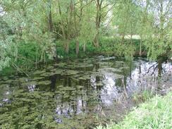
I walked westwards along the A631 and A46 for a couple of miles through Market Rasen, and I was glad that there was a pavement that I could use as they were not the quietest roads in the world. Unfortunately when I had to turn south to follow the A146 southwards the pavement ended, but I only had to follow the road for a few hundred yards before following a track that led to Cedar Farm. This marked the start of a footpath that headed westwards across fields, skirting a stream. It was a relief to be off the road and onto footpaths for the first time today, but on the downside the grass was wet with dew and as I was only wearing trainers my feet soon got soaking wet. This was not too much of a hardship initially, although I was to pay the price for this later in the day. I got slightly lost at one stage where the path crossed from the south to the north bank of the stream, and I had to backtrack to find where the footpath officially crossed.
This setback aside, I soon reached the road in Newton by Toft and started walking along it southwards towards Newtoft. As I was feeling fit I started to yomp; walking for three or four minutes followed by a jog for the same amount of time. This took my average speed up to four miles an hour, which I was quite glad about. My initial target was the trig point to the west of Newtoft, and I soon found it buried deep in a hedgerow just down a driveway off a private road. It was so deeply buried inside the hedge that it was quite hard to photograph it, and I ended up getting some quite unsatisfactory shots of it. After trying to find some better angles I headed back to the road and yomped southwards and then eastwards towards the village of Faldingworth. All the yomping was making my quite tired, so I stopped yomping and started walking as I turned to head south along a footpath past Shaft Wood to the A46.
Fortunately I only had to follow the A46 for a couple of hundred yards before I turned down a road that led southeastwards through Friesthorpe, where there was a house with a series of small windmills outside it. Just outside the village I took a footpath that led across a field of oil-seed rape, skirting the edge of Wickenby Wood before ending at another road. A few yards along this road was a bridge over the railway line, and this marked the second trig point of the day. I had some difficulty finding this pillar, but I eventually found it embedded in the bank between the railway line and the road. If the pillar in Newtoft had been hard to photograph this one was even worse; it was totally encompassed by the hedge and a growth of thick brambles. I eventually managed to scramble up the bank enough to take some photographs and record the flush bracket number, but I have certainly seen better pillars. Another short section of footpath took me to a road, and I then followed this southwards into the village of Snelland.
From Snelland I followed a bridleway that was easy to follow as it headed south along field boundaries towards the northern edge of Stainton Wood, where it turned to head southwards along a broad track. The bridleway through Stainton Wood was pleasant but fairly boring, before reaching the A158 road just to the west of Bullington. I could follow a stretch of old road past a series of parked cars, the occupants of which were munching on bacon sandwiches, hot dogs and burgers. This raised hopes in my ravenously hungry mind that there might be a burger van in the vicinity, and I was very glad when I was found one near the end of the lay-by. I decided to have a small bacon bap, and as there was bacon on the hotplate I got it very quickly, indeed within the time it took me to hand the money over. I munched on the bap as I headed along the road, before leaving it to start the climb uphill along a hedge to reach the location where there was meant to be a trig point.
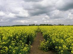
Once I reached the spot where my GPS reported the trig point should be it was not immediately obvious. I wandered around the open section of the field, inspecting the hedges for the pillar, but I could not see it anywhere. I was aware that some of the places I was looking were too far northeast, but I could not really explore the western area due to the tall rape crops. Eventually I gave up, not wishing to trample the crops, and headed back down the edge of the field to the road. I shall have to return here sometime in autumn or winter when there are no crops to se if I can find the pillar. The journey back down the field saw me being covered with yet more rapeseed pollen, and I ended up with my trousers and shirt sleeves being coloured yellow by the pollen. It is certainly a good job that I do not get hay fever! A quick tramp along the road took me past the pub in Langworth, which I was extremely tempted to nip into, but I decided not to and to walk onto the next pub marked on the map, a little under a mile away.
The road crossed the railway line at a level crossing and I soon reached the new pub, which I was disappointed to see was more like a high class restaurant. Covered as I was in a yellow coating of pollen I did not think that I would fit in, so I diverted off to the right that led into Sudbrooke Park. It was here that I got a major surprise when I suddenly came across an enclosure with some nodding donkeys in. I had last seen some of these in the Poole area on my coastal walk, and I had absolutely no idea that there were oil wells (even on a small scale) in Lincolnshire! I took a few photographs of the pump heads moving up and down, before heading on westwards along a track that passed a wooded area that was full of scouts enjoying themselves; apparently the woodland is an official scout camping area. The track was a quite easy and pleasant walk, and it soon led through to a road in a housing estate and then another road.
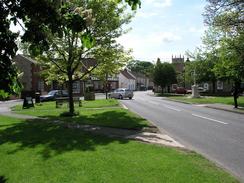
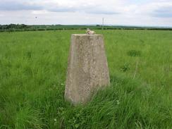
As I walked along the road that leads from Sudbrooke to Nettleham I started to feel quite tired, and I started to feel the effects of the walk so far, particularly in my feet, which had got wet earlier on. I could feel hotspots starting to form on them, and I knew that this was the precursor to getting some serous blisters. Instead of stopping I walked on into the centre of Nettleham, which was a nice little village, before heading out towards the Lincolnshire police headquarters, the buildings of which dominate the western side of the village. Before I reached them, however, I diverted off to the left along a footpath that headed northwards up a slight hill, and after a few hundred yards along this path I turned left and crossed a field to reach the final trig point of the day. This was by far the nest pillar of the three and unlike the two that I had visited earlier in the day, there were actually some views to be had from the slight hill on which it stood.
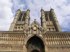
After savouring the views for a few minutes I decided to move on; instead of heading back the way I came I decided to follow field boundaries southwestwards down to the A46. I soon reached the road, and once there I stopped to fill up my main water bottle from my spare, as I was low on water. Ideally I should have done this earlier as by now I was quite thirsty, and I ended up drinking a third of a bottle of water straight down. The A46 headed straight down southwestwards into the centre of Lincoln; a walk that I did not enjoy very much as it was alongside a busy road and my feet were feeling very sore. Eventually I reached the centre of the city and I was greeted by the magnificent and stupendous sight of the Cathedral; a true masterpiece in stone. Despite my weary feet I walked around it, taking photographs of various aspects of the structure, before heading through an archway and started in the walk through the city centre to the station and the end of the walk. Lincoln was bustling with shoppers on this Saturday afternoon, but the only thing that I could focus on was reaching the end and resting my feet. Once I reached the station I plodded the short distance back to my car, happy that I had completed the longest walk of the year so far.
Directions
This walk starts off at Market Rasen railway station. Leave the station and walk northwards along the track that leads up to meet Dear Street by a railway bridge. Turn left and follow Dear Street northwestwards through Market Rasen until it meets the A631 Gainsborough Road. At the junction turn left, and walk westwards along the A631 for about a mile until it reaches Middle Rasen. Continue along the road through Market Rasen, and once out of the village turn left to follow the A46 as it heads southwards for a couple of hundred yards until a track leads off to the right. Follow this track as it heads westwards before curving around to pass Cedar Farm, and then turn right along a footpath that heads westwards across fields. The footpath crosses a stream before following the southern bank of the stream westwards. After a little over a kilometre a track is reached; turn right along this track for a few yards to cross the stream and then turn left to continue westwards along the northern bank of the stream. When this reaches an area of scrubland on the left turn left to cross the stream once more, and then follow the southern bank of the stream for another kilometre until it reaches a shed.
At the shed the footpath turns to the left slightly to turn southwestwards before it finally ends at a road in Newton by Toft. Once at the road turn left and follow it as it turns to the right and then almost immediately to the left, to continue southwards for another kilometre before turning to the right once more. When the road turns to the left again, continue straight on westwards down Alexandria Road; the road soon passes some rusting private road signs; pass these and then turn to the left down an access driveway until a trig point is reached buried in a hedge on the left. Once you have visited the pillar return to Alexandria Road and follow this eastwards back to the public road. Once there turn right and follow it southwards for a couple of miles until it ends at a T-junction, and then turn left along another road that leads eastwards for another kilometre into the village of Faldingworth. Enter the village, but after a short distance turn right down a footpath that heads southwards across a field; it skirts the edge of Shaft Wood before ending at the A46 road. Turn left and follow the A46 eastwards for a hundred yards until the A46 turns sharply to the left by a garage; here turn right down another road.
Follow this road as it heads southeastwards through Friesthorpe, passing the church until it turns sharply to the left at the southern edge of the village. Here turn right down a track for a few yards before turning left to join a footpath that heads southwards across fields; it skirts the western edge of Wickenby Wood before eventually ending at a road. At the road turn left and follow it eastwards for a few yards to a bridge over the railway line and onwards down a slight slope until a house is reached on the left, where a footpath leads off to the right. Turn right to join this footpath; there is another trig point a short way away to the right, sitting in a hedge on the triangular corner formed by the road, the railway line and the field. Otherwise follow the footpath as it heads southwestwards for a couple of hundred yards until it ends at a road. Once at the road turn right and follow it as it heads southwestwards and then southwards into Snelland.
When the road curves to the right in Snelland continue straight on southwards along another road; this soon becomes a track and shortly after it turns sharply to the left turn right and join a bridleway. This bridleway heads southwards along fields before meeting Stainton Wood; it skirts the edge of the woodland for a hundred yards before entering it and following a track southwards for a kilometre through it until it ends at the A158 road. Once at the A158 turn right and follow it southwestwards; a couple of long lay-bys, first on the right and then on the left, means that you can avoid the road; after the second of these a pavement starts on the right-hand side of the road. Follow the A158 into Langworth and then onwards until a level crossing is reached. A few yards beyond the level crossing turn right along a bridleway that heads northwards until it meets a track, and then turn to the left to follow the track westwards for a few yards. It then turns to head northwestwards for a short distance before ending at the locked gates of an oil well compound.
Just before the compound is reached turn left along a track that heads westwards through a wooded area. The track curves around but keeps on a rough westerly course for about a kilometre, joining a road through a housing estate before eventually ending at a T-junction with another road. At this junction turn right to head northwards for a few yards before taking the first road off to the left, which leads on past a little church before heading westwards into Nettleham. The road enters Nettleham along Sudbrooke Road; once in the centre of the village turn right along Vicarage Lane towards the village square, and continue on up for a few yards up East Street. Once Deepdale Lane is reached on the left turn to the left and follow it as it heads westwards. A short distance beyond All Saints Lane on the left turn right and follow a footpath that heads northwards up a slight hill. As it nears the top of the hill turn to the left through a gate and head for a short distance westwards to the trig point, which stands proud in the middle of a field. Continue on past the trig point, and once at a hedge turn left and go through a gate before following the edge of the field down to the A46 Lincoln road.
Once at the A46 road turn left and start following it southwestwards; thankfully there is a pavement that makes the walk safe. Continue on to a roundabout with the A158 road, and then continue straight on along the B1182 Nettleham Road until it reaches another roundabout with the B1273 road. Continue straight on, still following Nettleham Road until it ends about a kilometre later at a crossroads with Eastgate. At the junction take a path that leads off across some grass to the right, passing in front of a statue and reaching the eastern end of Lincoln Cathedral. Follow the southern side of the Cathedral to the main entrance, and then go through a gateway to a small market square. Turn left and start following a road that heads sown a step hill; this soon becomes the High Street as it heads southwards. The gradient flattens as it approaches the bridge over the River Witham before reaching the A57 road near a church. At the A57 turn left and follow the road eastwards for about a hundred yards. Lincoln railway station, where this walk ends, is on the right on the other side of the road.
Distances
| From | To | Distance (m) | Ascent (ft) | Descent (ft) |
|---|---|---|---|---|
| Market Rasen | Friesthorpe | 9.2 | 89 | 131 |
| Friesthorpe | Langworth | 5.9 | 105 | 128 |
| Langworth | Lincoln Station | 9.0 | 295 | 312 |
This makes a total distance of 24.1 miles, with 489 feet of ascent and 571 feet of descent.
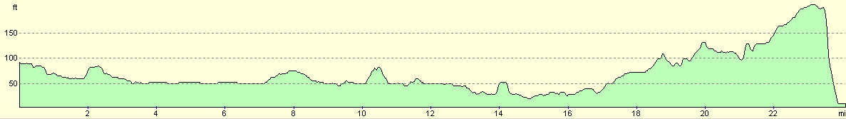
For more information on profiles, ascents and descents, see this page
Transport
There are some train services between Lincoln and Market Rasen. These are slightly irregular, but they are frequent enough to be useful.
Disclaimer
Please note that I take no responsibility for anything that may happen when following these directions. If you intend to follow this route, then please use the relevant maps and check the route out before you go out. As always when walking, use common sense and you should be fine.
If you find any information on any of these routes that is inaccurate, or you wish to add anything, then please email me.
All images on this site are © of the author. Any reproduction, retransmissions, or republication of all or part of any document found on this site is expressly prohibited, unless the author has explicitly granted its prior written consent to so reproduce, retransmit, or republish the material. All other rights reserved.
Although this site includes links providing convenient direct access to other Internet sites, I do not endorse, approve, certify or make warranties or representations as to the accuracy of the information on these sites.
And finally, enjoy your walking!
Nearby walks
| # | Title | Walk length (miles) |
|---|---|---|
| 600 | Newark on Trent to Lincoln | 19.5 |
| 896 | Ancaster to Lincoln | 20.6 |
| 899 | Lincoln to Woodhall Spa | 24.4 |
|
|

|