Walk #600: Newark on Trent to Lincoln
 |
 |
|
General Data
| Date Walked | 09/04/2004 |
| County | Nottinghamshire, Lincolnshire |
| Start Location | Newark-on-Trent station |
| End Location | Lincoln |
| Start time | 08.53 |
| End time | 15.46 |
| Distance | 19.5 miles |
| Description | This was a surprisingly enjoyable road and track walk northeastwards between these two lovely cities. |
| Pack | Today I carried my 30-litre Karrimor HotRock rucksack, which was filled with my waterproof leggings, water bottle, trainers and a couple of spare shirts, together with the usual assortment of odds and ends. It weighed slightly more than usual as I also had a bit of extra kit, such as my Psion, battery charger, cables and a tripod strapped to the side of the rucksack. |
| Condition | I feel slightly more fatigued than usual after this walk, as a result of the fact that I did a little bit of yomping early on. I have no blisters after the walk, and my feet feel absolutely fine. |
| Weather | The day started off foggy as I drove north along the M11, but this was soon replaced by bright sunny skies, and the first warm walking day of the year. There was a slight chilly breeze early on, although as the sun rose in the sky this dissipated. Towards the end of the walk grey clouds came over and these threatened rain, although fortunately this did not occur. All in all it was a lovely day for a walk. |
| OS map | Landranger number 121 (Lincoln & Newark-on-Trent) |
 |
 |
|
Map of the walk
Maps courtesy of Google Maps. Route for indicative purposes only, and may have been plotted after the walk. Please let me have comments on what you think of this new format. For a detailed table of timings for this walk, please see the table file.
Notes
As part of my plan to walk to every county top in Britain, I want to be able to walk to Lincolnshire's highest point, which is situated on the Wolds well to the northeast of Lincoln. I had two options about how to get there; I could either spend a day walking to the top from Grimsby, or I could walk diagonally across the county from Nottingham to Grimsby, and take in the top on the way. I soon decided that the best route would be to follow the Trent from near Nottingham to Newark-on-Trent, and then walk to Lincoln, Market Rasen and from there to the county top, before eventually reaching the sea near Grimsby or the Humber near Barton-upon-Humber. This involves four or five days walking, and I decided that today would be a good opportunity to start it off.
I decided not to start with the obvious first leg to Newark-on-Trent, but to instead do the leg from Newark to Lincoln. This was going to be about twenty miles of road walking, and so I made the decision to wear trainers rather than boots. It was foggy as I set off from Cambridge, but this was soon replaced with glorious sunshine before I reached Newark. The journey was quite quick, and the A1 was remarkably quiet considering that this was the start of a long Easter bank holiday weekend - I can only assume that most people left last night, or were leaving the journey until later in the day. I found a long-stay car park that was right beside Newark Castle railway station, and I paid the couple of pounds that it cost to park there all day before setting off through the town.
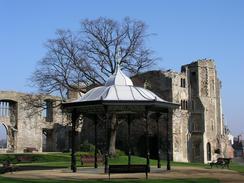
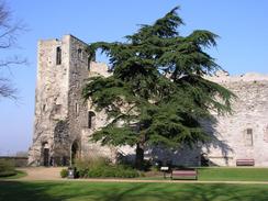
This was my first visit to Newark, and I was immediately massively impressed by it. Newark Castle station itself was not much to write home about, but a hundred yards after leaving it a pretty bridge over the River Trent is reached, and, on the northern bank of the river, the dominating curtain wall of Newark Castle is reached. This was quite a stunning view, and I promptly decided that it was worth spending ten minutes having a look around it. Not much remains aside from the tall riverside curtain wall and the gatehouse, the rest of the castle was destroyed during the Civil War, when the castle was a Royalist stronghold. The first stone castle was built by the Bishop of Lincoln, the so-called 'Alexander the Magnificent' - a title you really would not expect to see a religious man being called!. King John died in the castle in 1216, which caused a weeklong siege after which the castle returned to the ownership of the Bishop of Lincoln. Eventually Henry VIII took over the castle in 1547, and a little under a century later it withstood three bitter sieges in 1643, 1644 and 1646, before eventually being ordered to surrender to the parliamentarians. The grounds of the castle behind the curtain wall are very nice, with a prominent bandstand standing amongst some trees.
The walk around the castle put me in a very good mood, and when I finally left I was delighted to find that the rest of Newark was just as nice. A narrow street took me to the market square, where a bustling market was in progress. A swift walk around the square took me to W.H, Smiths, where I bought a DVD of 'Touching the Void', a marvellous film of a brutal mountaineering mishap in 1986; it is amazing how such stories of hardship can be strangely uplifting. I had a quick look around the massive church, before reluctantly heading eastwards out of the town. The road led me across the East Coast Main Line and the A1(T), before depositing me in the pretty little village of Coddington. I took a few photographs of the church before heading off out of the village, only to reach a long queue of near-stationary traffic at the roundabout on the A17(T). The slow traffic made it quite difficult to find a gap in which to cross the road, and I had to wait for an annoying three or four minutes before I could dash across.
Looking around Newark first thing had slowed my pace down to a little over two miles an hour, and so to get a better average I decide to yomp for a short period. The road I was on passed northeastwards through Stapleford Wood, and as it was quiet I would jog for a minute, walk for two, and the repeat the cycle. I was taught this technique at school, and although it is hard on the feet and legs (particularly with a pack on) it soon allowed me to reach three miles an hour average speed without hurting myself. I stopped yomping when I reached the road emerged from the woodland, and I started walking eastwards into the village of Stapleford. It did not take me long to pass through this tiny village, and the only item of any real interest was the church, standing on its own on the banks of the River Witham.
A track, a short stretch of road and another track took me to a trig point just to the east of Scotwater Bridge. I did my usual trick of photographing the trig point before heading the few yards to the road, where I was amused to find a large pile of what must have been literally tons of carrots. I took some photographs of these before making a little stick man out of carrots, a silly but strangely diverting task. Another miles of road walking took me into Bassingham, where I promptly found the nice church. I walked around it taking photographs of the exterior before deciding to go inside for a look around. I opened the door slightly, only to be greeted by many heads turning my way; I was interrupting their Good Friday service. Startled, I shut the door and headed off back through the village. I had decided to stop in the village for a drink, and when I found that the Bugle Horn pub was open I nipped in for a quick drink. They had a fire on that made the pub stiflingly hot, but a pint of glorious Oyster Stout was swiftly followed by another half pint. It felt nice to be relaxing in a nice country pub, and I found it hard to tear myself away for the rest of the walk.
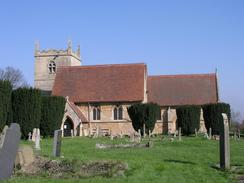
The church at Aubourn is quite strange; it looks strangely incomplete, as if over half the structure has been demolished. Only a small portion of what must have been a much larger church is still extant, and that is in bad condition, as could be seen from misplaced slates on the roof. What remained was quite picturesque, however, and it was well worth taking a picture or two of it. From Aubourn itself a track lead to a bridge over the River Witham; the bridge marked on the map, however, is shown as being in a dangerous state and so I had to diver a couple of hundred yards to a much better bridge. When I got back to the original bridge, however, I saw a family complete with young children crossing it; something that I would not have advised them to do. The track ended at a road in South Hykeham, and this marked the start of the last section of the walk northeastwards into Lincoln.
The road led on through North Hykeham before eventually reaching the A1434 road in Boultham. I had intended to walk along roads into the centre of the city, but I saw signs for a cycle path that skirted the western bank of the River Witham northwards, a far better walk during which I could see the magnificent Lincoln Cathedral on the hillside above me. The fields skirting the path had horse sin them, and a seemingly endless stream of people heading towards with me with bags heavy with shopping, stopped to feed them little titbits such as carrots and apples - they must be very well-fed horses. Eventually the cycle path ended at a road and I was forced to follow roads northwards into the city centre, passing a large works beside the river before reaching the old St Marks, once a busy and bustling railway station, which closed on the relatively late date of May 11th 1985. The area remained derelict until 1993, when (what else!) a shopping centre was built on the site. This is actually quite nice, and apparently the closure of the station and the concentration of all services onto the other station have actually improved services for passengers, as they no longer need to walk between stations when changing trains.
I enjoyed the walk though the shopping centre, with old signs of the railway station having been skilfully merged into the new infrastructure of the shopping centre. I soon arrived at the railway station, and I bought a ticket and had forty minutes to wait for a train back to Newark. I was tempted to walk up the hill towards the Cathedral and Castle, but I eventually decided to have a rest and leave that exploration for the next stage of the trip to Market Rasen - today had been nice and satisfying enough without adding a cathedral onto the end. Today's walk was also notable as it was my six hundredth walk since I started logging them on January 1st, 1999. If you had told me then, as I set off on the walk to Shining Tor, that within five and a half years I would have walked nearly ten thousand miles in 600 walks, I would have found it exceedingly hard to believe you. I am getting no small sense of achievement from reaching this milestone, and I have now set myself the target of reaching my 10,000 mile by the end of the year - I have got 254 miles to go, and this means that it should easily be achievable. I daresay I may treat myself to a drink at that point!
Directions
This walk starts off at Newark Castle railway station, on the northwestern side of the town. Leave the station and turn left to walk southeastwards along the Great North Road, after a hundred yards reaching a bridge over the River Trent, before climbing up a short hill past the castle to a T-junction. At the T-junction turn to the right and then take the first road to the left, which heads eastwards to the Market Square. Cross the square and then continue straight on along Barnaby Gate, before turning to the left down Sherwood Avenue. This turns to the right before ending at a T-junction with Sleaford Road. At the junction turn right and follow the road as it almost immediately crosses over the East Coast railway line, before climbing up Beacon Hill and, a mile after the railway line, reaching a bridge over the A1(T). Continue on along the road as it heads eastwards towards Coddington. On entering the village take the first road to the right, Bornlow Hill, which soon becomes Main Street as it curves around past the church.
Shortly after the road curves to the left a road junction is reached; here turn to the right and follow Beckingham Road eastwards for a little under a kilometre until a roundabout is reached with the A17(T). At the roundabout turn half-left, to take Stapleford Lane northeastwards. This road soon enters Stapleford Woods, and is quite a nice road walk for a couple of miles (note that for the stretch through the woods there may be non-road alternative paths along tracks through the woodland). The lane becomes Coddington Lane halfway through the woods, and it eventually emerges before ending at a T-junction. At this junction turn right and follow Newark Road as it heads eastwards into the village of Stapleford; walk through the village and when the road turns sharply to the left turn right down Broughton Road for literally a couple of yards; from here a footpath leads eastwards towards Stapleford Church. The footpath goes through the churchyard, before continuing on to a bridge over the River Witham and ending at Clay Lane.
At Clay Lane turn left and follow the road as it heads northeastwards until it curves to the right; instead of following the road continue straight on along a track that heads northwards for a little under a kilometre, passing a trig point on the right before ending at a T-junction with the curiously-names Norton Disney Road. Turn right along this road for a hundred yards before turning left along Rinks Lane, which heads northeastwards for a kilometre into the village of Bassingham. Pass the church and the turn right along a road that heads eastwards for a few yards, before taking the first road off to the left. This heads northeastwards, passing the Bugle Horn pub, and heads on until a T-junction is reached. At the junction turn right and then almost immediately to the left, to head northwards for a short distance until a junction with Thurlby Road is reached. Continue straight on northwards along Lincoln Road, which winds around on its northerly course, and becomes Bassingham Road before passing the ruins of Aubourn Church.
The road slowly curves around to a more easterly course, passing a junction with Bridge Road on the left before entering Aubourn. At a one-way system continue straight on along Chapel Lane; when this ends turn left and then immediately right to head eastwards out of the village along Harmston Road. Continue on for a few hundred yards before turning left along a bridleway that passes to the right of a garden before reaching the flood bank of the River Witham. The bridge over the river marked on the Ordnance Survey map is signposted as being dangerous for pedestrians, so turn to the left and walk along the flood bank for a few hundred yards to a footbridge over the river, before returning back to the old bridge along the northern flood bank. Once back at the bridge turn left and follow a track that heads slightly east of northwards for a mile until it ends at a road junction near South Hykeham Church. At this road junction continue straight on along Beck Lane, which can be followed as it becomes Mill Lane and heads northwards.
As the road enters North Hykeham it curves to the northeast and continues in this direction for a little over two miles until it ends at a T-junction with the A1434 Newark Road. Turn right for a few yards before turning left down a cycle path that heads northwards a short distance to the west of the River Witham. The cycle path crosses a stream on a wooden bridge before ending at Hall Drive. Head straight on northwards along Hall Drive, and when it ends continue on along Boultham Park Road as it crosses the B13660 Valentine Road before ending at a T-junction with Coulson Road. Turn right along Coulson Road for a short distance before turning left along another cycle path that follows the western bank of the River Witham northwards. At the third bridge over the river (called the Rope Walk) turn right and follow the road eastwards as it becomes St Mark Street and ends at the High Street in Lincoln. Turn left and head north for a couple of hundred yards as it crosses a level crossing and reaches the A57. Turn right along the A57 and follow it eastwards for a few yards until the forecourt of Lincoln Station is reached on the right, where this walk ends.
Distances
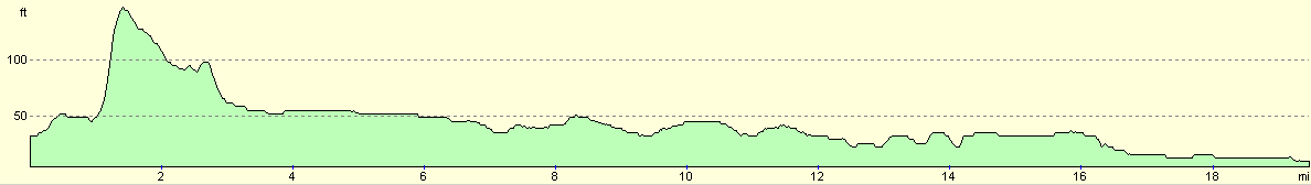
| From | To | Distance (m) | Ascent (ft) | Descent (ft) |
|---|---|---|---|---|
| Newark Castle Station | Bassingham Church | 9.4 | 161 | 161 |
| Bassingham Church | Lincoln Station | 10.1 | 82 | 105 |
This makes a total distance of 19.5 miles, with 243 feet of ascent and 266 feet of descent.
For more information on profiles, ascents and descents, see this page
Transport
There are regular (sometimes less than hourly) railway services between Lincoln and Newark Castle stations. A single ticket cost me £2.90, and the journey takes less than half an hour. There is a long-stay car park adjacent to Newark Castle station.
Disclaimer
Please note that I take no responsibility for anything that may happen when following these directions. If you intend to follow this route, then please use the relevant maps and check the route out before you go out. As always when walking, use common sense and you should be fine.
If you find any information on any of these routes that is inaccurate, or you wish to add anything, then please email me.
All images on this site are © of the author. Any reproduction, retransmissions, or republication of all or part of any document found on this site is expressly prohibited, unless the author has explicitly granted its prior written consent to so reproduce, retransmit, or republish the material. All other rights reserved.
Although this site includes links providing convenient direct access to other Internet sites, I do not endorse, approve, certify or make warranties or representations as to the accuracy of the information on these sites.
And finally, enjoy your walking!
Nearby walks
| # | Title | Walk length (miles) |
|---|---|---|
| 608 | Market Rasen to Lincoln | 24.1 |
| 723 | Newark to Carlton | 20.7 |
| 895 | Bottesford to Ancaster | 20.3 |
|
|

|