Walk #723: Newark to Carlton
 |
 |
|
General Data
| Date Walked | 22/04/2006 |
| County | Nottinghamshire |
| Start Location | Newark-on-Trent station |
| End Location | Carlton station |
| Start time | 09.25 |
| End time | 17.07 |
| Distance | 20.7 miles |
| Description | This was a pleasant walk, mostly following the Trent Valley Way as it heads southwestwards towards Nottingham. |
| Pack | Today I carried my 30-litre Karrimor rucksack filled with my waterproofs, two litres of water, a book and various other odds and ends. |
| Condition | I am relatively okay after this walk, and if I had more time could have walked further. The biggest problem was with some sharp pains in my right hip that flared up occasionally as I walked. |
| Weather | The day was a mixture of sunshine and cloud; it was not too cold a day, but a breeze forced me to war my fleece all day. |
| OS map | Landranger number 120 (Mansfield & Worksop, Sherwood Forest) and Landranger number 129 (Nottingham & Loughborough, Melton Mowbray) |
 |
 |
|
 |
 |
|
Map of the walk
Maps courtesy of Google Maps. Route for indicative purposes only, and may have been plotted after the walk. Please let me have comments on what you think of this new format. For a detailed table of timings for this walk, please see the table file.
 |
 |
|
Notes
I have been feeling bad for some time that I have not yet connected my walk from Newark-on-Trent to Market Rasen up with any other walks, despite them having been done nearly two years ago. For this reason I found myself driving north up the A1 towards Nottinghamshire and Newark. Some road works delayed me slightly, but I soon parked up in the car park at Newark Castle station, paid two pounds for an all-day ticket and got ready for the walk. Before I set off I walked up onto the station platform to check the train times for the journey back, and walked over the level crossing to get a glimpse of the magnificent ruins of Newark Castle.
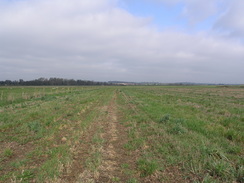
A road led away from the station towards the A46, which proved difficult to cross because of the heavy traffic low, including many cars towing caravans. Once over this a short field led across to the A617 road, which again proved to be slightly difficult to cross. Next came some rugby fields, including a small stand to the left, and after this came more fields. The path across one of these proved to be very tight, with an electric fence only leaving about a foot between it and the fence. As I did not want to disturb the sheep in the field to the left protected by the electric fence, I climbed over the fence and walked in the field to the right.
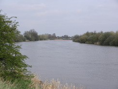
The path ended surprisingly soon at the A617 once more, and almost immediately I crossed the River Trent by the large bridge and followed the road through Kelham. There were a couple of attractive buildings visible to the left that seem to have recently converted into houses or apartments; I assume that these were once part of the buildings related to the nearby Kelham Hall. A minor road led off to the right, and before long I diverted off to the left along a track. This was soon left behind and a footpath headed up a slight hill, giving some good views down over the Trent Valley to the east. The next stretch of footpath proved to be slightly hard to follow as it headed across a series of fields towards a minor road.
On the other side of the road the path headed towards the buildings of Kelham Hall, but before these were reached the path careful crossed what appeared to be a recently-constructed horse gallops, the white railings and damp fresh sand making it look extremely plush. There a sign warning walkers on the Trent Valley Way against oncoming horses, and I checked carefully in both directions before crossing and heading along. I soon reached the other side of the looped gallops, and here the path descended down to another gap in the railings. Again I checked, but as horses were coming I took a few steps back. The first horse seemed to be spooked by my presence near the railings, and as it passed the rider yelled at me to keep right back. This I did, climbing up to the top of the bank and waiting for what seemed like an endless stream of horses to pass by.
Once all of the horses had passed I jogged across the gallops and followed the path as it passed through the stables. Here as well as the classic stables buildings there were also some other round buildings; when I passed one of these I saw that they were split up into four partitions with moving blades rotating inside; in each of these partitions was a horse. I can only assume that this was some form of horse exercising machine. The stables were soon left behind and after passing some houses a path led on though Aveham Park, heading roughly southwards towards the A617 road.
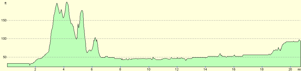
A short stroll along the A617 led me to another footpath that headed steeply up Micklebarrow Hill. As I crossed the stile a man was heading down the hill towards me, and I walked towards him, passing him before I reached a hedge line. This proved to be a mistake as I cold find no trace of the path, and I wandered around fro a few minutes before realising that I had headed in too much of an easterly direction. Annoyed, I walked along the crest of the hill to join the path proper, that passed near to an impressive house before heading down the southern side of the hill. Again I went off course here, heading too far to the west, something I corrected at the bottom of the hill when I rejoined the proper path and headed across one last fields before reaching the A612 road.
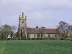
I had to walk carefully along this road as there was no pavement, but it had fairly wide verges and the traffic was light, so this was not too bothersome. Upton seemed like quite a nice little village, and I walked past the pub before reaching the little but remarkably pretty church. I studied this for a couple of minutes before joining a path that headed downhill away from the church, and I stopped occasionally to turn around and take a look at the picturesque view of the church on the skyline, progressively getting smaller as I walked away from it.
Once off the hill the path went over some flat land to reach Car Dyke, and I found myself wondering if this is related to the Roman Carr Dyke canal that ran from Waterbeach near Cambridge to Lincoln. Some more flat land took me towards a golf course, and I had to be careful as the path squeezed between some greens and the River Greet. To my right across the small river I could clearly make out the grandstands of Southwell Racecourse, and I was relieved when the path passed an old mill building and left the golf course. This heralded the entrance to the village of Rolleston, which had a larger but less picturesque church than Upton. I was looking for a footpath that would head south from the village towards Fiskerton and the Trent, but this proved harder than I expected to find, and I thought that I must of passed it before I eventually find the start of the path.
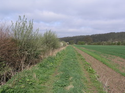
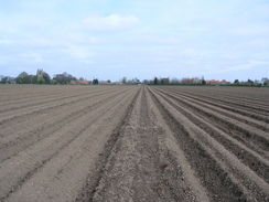
The path headed behind some houses before crossing a recently-ploughed field (for once, the farmer had done a god job of preparing the path for walkers, with little signs and a flattened path across the ruts. It joined some flood banking beside the River Greet as it headed through a nice stretch of trees, and continued on this as it headed away from the river and curved before ending at a road near Fiskerton Mill. Here the road was a few yards away from the river, but within a couple of minutes I was walking alongside the river as it headed through Fiskerton, the road taking a route slightly away from the river. Before I left the village the path passed a pub, and although I was thirsty I decided not to take a break as the pub seemed rather posh, and there was another pub marked on the map a few miles further on, nearer the halfway point of the day.
The path left the village through a curious double gate the gates being attached on the same post and one opening towards me and the other away from me, an arrangement that I have never seen before. These proved to be common as I walked along the Trent, there being several other sets before I reached the weir and lock at Hazelford. The locks is fairly large, and the weir sparkled in the bright sunshine, but as the weir was between myself and the lock I could not get a particularly good view of it. As I headed away from the lock, passing a couple of large boards directing boats away from the weir, I felt a sharp stabbing pain in my right hip. This got worse over the next few steps, and I soon had to stop to give it a rub.
The rub did some good, and I continued on with the aim of stopping at the pub marked on the map at Hazelford Ferry. Unfortunately as I approached this I found that it was now part of a caravan site, and as there were no visible pub signs I decided to walk on without stopping; I have no idea of it is open to the public, or even if it is still a pub, but it was a disappointment not to stop, particularly as my hip was aching on occasion. The next stretch of path was fairly pedestrian, made more interesting by the gliders that were taking off from the airfield high up on the other side of the river. Some of these were self-propelled gliders, and others were towed up by cable. For a couple of the latter I saw the cable drop off the glider once it had been launched and fall to the ground, slowed by a little parachute.
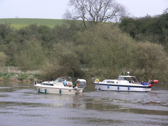
On the other side of the river there was some small sailing boats on some lakes, part of a complex of flooded sand pits, and as I watched these and the gliders overhead a large cruiser came speeding past me on the river, leaving a large wake behind it that soon washed up noisily on the banks near me. The path joined a road for a short distance near Hoveringham, where it passed he entrance to a country park that was apparently very popular as the car park was packed. The road was soon left behind as the path followed the river along a pleasant stretch of river bank that headed southwestwards. Unlike earlier stretches of the walk this was fairly popular, with many people out for a walk on this sunny afternoon.
The river curved around to a more westerly course before reaching Gunthorpe Lock, which was busy and bustling with people. There were several boats in the area, and I quickly walked past before I reached the Toll House pub, that I am sure was not here last time I passed through. As I was fairly tired I wanted to stop for a drink, but the pub looked rather plush and posh, and I hesitated before nipping inside. I bought a pint from the friendly barmaid and headed outside, to sit in the sunshine whilst I supped my drink and watched the people pass by. After a few minutes I decided to give a friend who lives nearby a phone, and we ended up chatting merrily away for half an hour before I eventually realised that I would have to go.
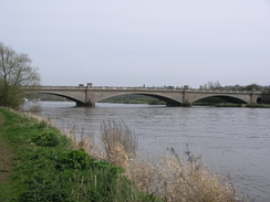
It was a short distance from the pub to Gunthorpe Bridge over the river, which was the first bridge over the river I had passed since Newark. Although the path passes under the bridge I walked up the ramp to the top of the bridge and crossed the road at the top so that I could have a look at some of the views, and look at some of the detailing on the bridge. Once on the other side a little track led down to the side of the river, and I continued along it through some fairly scrubby woodland. As I walked westwards a red boat came past towing a rubber ring with people in it; the people in the ring were obviously having a great time. The path soon emerged from the trees, and started curving around as the river started a big loop around Burton Meadows.
The sun was shining strongly by now, and was glinting off the surface of the river. It made the walk even more enjoyable, and as I strolled along I found myself wishing that I could continue onwards. Unfortunately time was pressing on, and it was now late afternoon, and so when the river curved once more to head away from Burton Joyce I cut across some grass to reach the station in the village. On the platforms I found that a train was due in ten minutes, but looking at the timetable I could see that there was another train in an hour, and the next station on the line, Carlton, was less than an hour's walk away. I therefore decided to walk on, but on studying the map I realised that I could not follow the path along the river and get to the station in time, so instead I elected to walk along the A612 road.
This was made easier by a pavement that ran alongside it, separating me from the traffic that travelled past. There was not much to note on the way into Gedling, except for a new by-pass for the A612 through Gedling that was under construction. To my right I could see the woods in Gedling where a friend lives, and I soon found myself passing under an old railway bridge (the line once ran to Gedling Colliery) and on into the centre of Gedling. A complex junction followed, and another couple of roads took me through a rather uninspiring part of suburban Nottingham to reach Carlton station. One I got there I had about twenty minutes to wait for the train, and so instead of waiting (the station had no seats for passengers) I went for a little walk around Carlton before heading back and sitting on the platform. As I waited the fumes from an adjacent chip shop wafted over me and these made me feel hungry, a situation that was thankfully resolved when the train arrived and I started the journey back to Newark.
Directions
Leave the car park at Newark Castle station and turn right to walk north away from the station for a few yards, before turning left along another road. This is part of the Trent Valley Way that will be followed for the majority of the day, and initially this heads westwards for a short distance before slowly curving to head in a more northwesterly course. After a few hundred yards the road ends, and a gate a footpath leads off to the right, immediately turning to the left to head across a field towards the A46 road. Cross the A46 road and on the other side continue on for a few yards to the A617. Cross this in turn, and continue on northwestwards, passing between some rugby fields on the left and right before entering a field.
The footpath is reasonably easy to follow as it crosses the fields, eventually ending at the A617 by a bridge over the River Trent. Here join the A617 and use it to cross the River Trent before following it through the village of Kelham. After a few hundred yards the road curve sharply to the left; immediately after this bend turn right along another road . Before the houses on the right end turn left and follow a track southwestwards. When this ends turn right and follow a hedge northwestwards, aiming for the corner of a patch of woodland, which it passes around before continuing up onto the Kelham Hills.
The footpath heads northwestwards, making a couple of little sideways jinks before reaching a road. Cross this road, and continue westwards along a footpath as it crosses a gallops twice and head through some stables. The oath joins a track leading away from the stables and passes some houses on the left; when a track leads off to the left join it and follow southwards past Aveham Park. It jinks to the left, right and then left once again, to finally head southeastwards across a field with a hedge to the left before ending at the A617 road. Join the road and turn left for a few yards until a footpath leads off to the right.
The footpath heads southwards up the steep flank of Micklebarrow Hill, and at the top nears, but does not reach, a house before curving to the right slightly to head back down the hill. The path joins the A612 road, and this is followed southwestwards into the village of Upton. Head into the village and pass the pub on the left; shortly after this turn left down a road that leads to Upton Church. Enter the graveyard and pass the church, but before leaving the churchyard turn left to join a footpath that heads south along the boundary. The path leaves the churchyard and heads downhill, crossing a stream before reaching Car Dyke, which it crosses before continuing on across a field, angling towards some flood banking.
The path climbs up onto the top of a flood bank and follows it southeastwards. When a stream comes in from the left the path diverts slightly to the left before crossing it; once across turn right once again and walk back to the flood bank. This heads between a golf course on the left and a river on the right. When an old mill building is reached the path heads to the left to bypass it; head past the building and join a track that crosses a railway line on a level crossing before curving to the left and reaching a road. Join this road and follow it as it heads through Rolleston, passing the church before reaching a road junction on the left. Follow the road past this junction as it curves to the right and then the left; just past this curve turn right along a footpath that heads southwestwards, skirting behind house before entering open fields.
The path crosses a field southwards, and on the other side heads through trees on a bank past Fiskerton Mill. The trees soon end, and the path continues on top of the bank as it curves to the left away from the river and soon to the right, to head southeastwards for a hundred yards to end at a road. Turn right along this road, and when it meets the river walk along the grass between the river on the left and the road on the right. The road soon curves away from the river, but the path continues on alongside the river through Fiskerton, passing a pub before leaving the village.
The river follows the northern bank of the river for about seven miles to Gunthorpe, initially passing Hazelford lock and then Hazelford Ferry, before settling on a more southwesterly course towards Hoveringham, Here the path joins a road for a short distance past the entrance to a country park, before heading off to the left to rejoin the riverside. Eventually the path reaches Gunthorpe Lock, and a short distance on it reaches Gunthorpe Bridge. Here my route leaves the Trent Valley Way that crosses over to the southern bank of the river; my route passes under the bridge and on along the northern bank of the river.
Initially the path heads westwards for about a mile before it starts curving to the left to follow the river in a wide curve around Burton Meadows. After this it curves around the southern side of the village of Burton Joyce, with a railway line immediately to the right. Once the river starts curving to the left away from the railway head slightly to the right across some grass, aiming for a level crossing immediately in front of Burton Joyce station. Join the road and cross the railway line, and head on northeastwards along the road for a couple of hundred yards until it ends at the A612 road.
Turn left and start heading southwestwards along the A612 as it head out of Burton Joyce towards Gedling. There is a pavement all the way, which makes it a safe walk. After a mile and a half the road passes under a rail bridge; immediately after this a road comes in from the right. Head straight on and follow the road as it curves to the left; immediately after this bend turn right along a road that crosses a stream before heading southwestwards for a little under half a mile. Once this road ends at a T-junction turn left, and follow another road south for a few yards until a level crossing is reached. The Newark-bound platforms are immediately on the left before the crossing.
Distances
| From | To | Distance (m) | Ascent (ft) | Descent (ft) |
|---|---|---|---|---|
| Newark station | Rolleston church | 7.6 | 381 | 367 |
| Rolleston church | Gunthorpe Bridge | 8.0 | 75 | 69 |
| Gunthorpe Bridge | Carlton station | 5.1 | 66 | 26 |
This makes a total distance of 20.7 miles, with 522 feet of ascent and 462 feet of descent.
For more information on profiles, ascents and descents, see this page
Transport
There are slightly irregular train serivces running between Carlton and Newark, calling at all of the stations inbetween. More regular services run direct between Nottingham and Newark on their way to Lincoln, and so if there is not a train for a while it may be worthwhile getting a bus into Nottingham and then catching a train. Note that this may need a walk between the bus and train stations, however. Check the National Rail timetables service for more information on rain times between the two stations.
Disclaimer
Please note that I take no responsibility for anything that may happen when following these directions. If you intend to follow this route, then please use the relevant maps and check the route out before you go out. As always when walking, use common sense and you should be fine.
If you find any information on any of these routes that is inaccurate, or you wish to add anything, then please email me.
All images on this site are © of the author. Any reproduction, retransmissions, or republication of all or part of any document found on this site is expressly prohibited, unless the author has explicitly granted its prior written consent to so reproduce, retransmit, or republish the material. All other rights reserved.
Although this site includes links providing convenient direct access to other Internet sites, I do not endorse, approve, certify or make warranties or representations as to the accuracy of the information on these sites.
And finally, enjoy your walking!
Nearby walks
| # | Title | Walk length (miles) |
|---|---|---|
| 66 | Melton Mowbray to Bingham | 16.1 |
| 76 | Bingham to Nottingham | 13.5 |
| 95 | Nottingham to Long Eaton | 10.3 |
|
|

|