Walk #724: Retford to Woodhouse
 |
 |
|
General Data
| Date Walked | 29/04/2006 |
| County | Nottinghamshire, South Yorkshire |
| Start Location | Retford station |
| End Location | Woodhouse station |
| Start time | 09.50 |
| End time | 18.10 |
| Distance | 23.4 miles |
| Description | This was a pleasant walk, following the Chesterfield Canal for most of the way before taking roads and footpaths westwards towards Sheffield. |
| Pack | Today I carried my 30-litre Karrimor rucksack filled with my waterproofs, two litres of water, a book and various other odds and ends. |
| Condition | The biggest problem that I have had today is some severe heat rash on my knees from the strapping that I use. Aside from this my feet were slightly sore, but there were no significant problems. My right knee ached on a couple of ocasions, but nothing too serious or painful. |
| Weather | The day was mostly sunny with some cloud, and there was also a quick shower of drizzle early on. It was a fairly warm day but the wind was slight chilly; all in all it was a nice day for a stroll. |
| OS map | Landranger number 120 (Mansfield & Worksop, Sherwood Forest) |
 |
 |
|
 |
 |
|
Map of the walk
Maps courtesy of Google Maps. Route for indicative purposes only, and may have been plotted after the walk. Please let me have comments on what you think of this new format. For a detailed table of timings for this walk, please see the table file.
 |
 |
|
 |
Notes
I tend to have a habit of planning to walk in a certain area (this year it was the Wales / England border), and then totally ignoring that area and walking elsewhere in the country. Thus, a third of the way through the year, I have done two walks in that area and instead have focussed on walking in other areas. The maps of my walks appears to be quite blank in north Nottinghamshire and South Yorkshire, so a few weeks ago I planned some walks based on Retford, and I found myself driving along the A1 this morning to reach the town and the start of a walk. I had three walks planned in the area, and as the day was sunny I decided to walk west along the Chesterfield canal towards Sheffield.
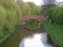
After parking my car in the car park by the station (it cost Ł3.50 for the day, paid before you leave), and started walking away from the station along roads. I soon reached a bridge over the River idle, and according to the map the canal was a few yards away to the north. Unfortunately there was a new housing development under construction in the area, and there was no way up onto the canal towpath. Instead I was forced to walk along the road towards the centre of the town, and one I found an open gate I walked the few yards into the canal towpath. Here the towpath was blocked, and a lady pointed me back to the road and a narrow alleyway a few yards away that led onto the canal by a lock.
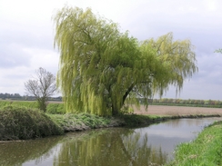
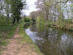
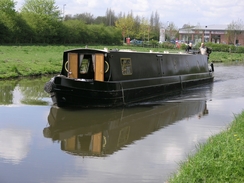
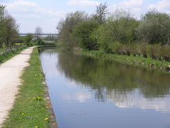
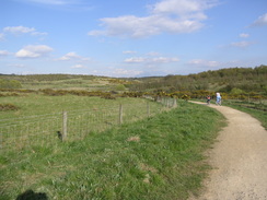
After crossing the canal at the lock I started along the towpath that ran along the northern side of the canal; intially this was a fairly straightforward walk as the canal headed northwestwards out of Retford. The canal passed on an aqueduct over the Rived Idle, which looked very pleasant with grass-lined banks beneath me, before passing a cemetery and passing under a railway bridge to enter open country. The next few miles were a very pleasant walk, with the Forrest flight of locks soon being reached beore the canal joined the A1, and started running southwards alongside the dual carriageway. Although the road was very noisy I only got a few glimpses of it, as the canal towpath was separated from the A1 by a minor road and some trees. The noise was very intrusive, and it contained to be so as the canal went through a series of curves to reach Ranby.
The Chesterfield Canal, which runs from the Trent to Chesterfield, was designed by James Brindley (although he died before completion) and was completed on the 4th of June 1777. It was split in two in 1907 when the roof of the long tunnel at Norwood collapsed, and the entire canal closed in 1962. However it was preserved, and over the years sections have slowly reopened at both the Chesterfield and Worksop areas, leaving just the area around Norwood Tunnel left to be reopened. A list of locks and other items of interest on the canal can be seen on Jim Shead's website and the Chesterfield Canal trust website is an interesting resource.
At Ranby there is a pub, The Chequers, that looked very inviting, but it was still fairly early in the walk for a stop and anyway, the pub was on the wrong side of the canal from the towpath. There is a bridge ove the canal a short distance to the north that I passed, so if you want to visit the pub use that to access the other side of the canal and the pub. The canal turned once more to head under the A1, and then started winding southwestwards. The further I walked the less the quieter the noise from the A1 became, and soon I found myself walking through some pleasant countryside once more.
The towpath crossed over the canal at a bridge and continued on along the southern side of the canal. Buildings near the hall were visible on the other side, including a fascinating octagonal building beside some stables. After about another kilometre the towpath switched over to the northern side of the canal once more, and continued southwestwards towards a large viaduct that carried the Worksop to Retford railway line over the canal. The viaduct was quite an impressive structure, brick built with old rails and tie bars being used to hold the structure together near the tops of the arches. One under the viaduct the canal started to enter the eastern outskirts of Worksop, and the next item of interest was a large brick-built sewage works on the other side of the canal. This looked as though it had been long disused, but the decoration on the building was still vivid, particularly on the tall chimney that stood alongside it.
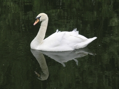
Soon after this the canal passes Bracebeidge Lock and headed on westwards towards the centre of the town. As I walked along the canal there was a duck paddling along, and beside to were two tiny ducklings. One of these was a dull brown colour, but the other was a highly conspicuous yellow that almost glowed against the water. It was a beautiful sight, and I took a few photographs of it before continuing on further along the canal towards the centre of the town. As I was about halfway through the day I decided to stop for a drink, and the first pub I tried had a sign stating no workmen's clothes. I knew that I was slight scruffy in my walking clothes, so I decided not to try this pub and instead walked to the Waterfront pub, which is situated directly over the canal.
I ordered a pint of John Smiths and a pack of crisps, and as the pub was crowded with people watching Manchester United play Chelsea I decided to sit outside in the sunshine. On another table nearby was a woman and three men who were obviously the worse for wear, and I chatted to them for a while as I supped my pint. The lady even said I looked like Gary Linekar, which is probably a sign of her tipsy state rather than an accurate description of how I looked. It was nice resting in the sun, so I decided to delay the walk slightly and have another pint, which again did not take long to drink.
Eventually I could not delay any longer, so I bade them goodbye and shouldered my rucksack, crossing the buy road before walking towards a supermarket to rejoin the canal towpath. This took me on northwestwards through Worksop, which proved to be an enjoyable stretch with a firm path underfoot. At one point the canal passed some playing fields, and players were putting padding around some rugby posts prior to a game. Eventually the A57 was reached near a recently-restored bridge; this section of the canal to the west of Worksop has been restored in the last few years, and the new brick-built bridges are fairly attractive.
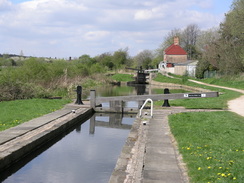
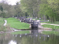
Shortly after this I passed the entrance to Shireoaks marina, which is built on the site of the old Shireoaks Colliery, which closed in the 1980s. From the neat surroundings it is hard to imagine that this sire was a colliery so recently, and although the loss of jobs and change in lifestyle is hard on the area, I cannot help but think that a marina is far nicer than a colliery. Shortly after this the canal passed right by Shireoaks station, and this led onto a long flight of locks, some of which were double locks, with three gates and no intermediate pound. This stretch of the canal had been very well restored, and it was a pleasant walk as the canal slowly rose up to the level of the Norwood Tunnel.
Once the summit level had been reached the canal felt more enclosed by the surrounding trees, and the water was murkier and more choked by weeds - a sign that boats rarely travel this stretch. As I passed a little bypass weir opposite Old Spring Wood I saw something move in the shallow water and was amazed to find a snake swimming around. I stopped to watch it as it repeatedly tried to climb the vertical wall on the far side of the channel, each time getting about a foot up before falling back into the water. I rarely see snakes whilst walking, so seeing one today was a highlight of the walk..
The canal went into a cutting before reaching the road at Kiveton park, and as the canal enters the Norwood Tunnel a few hundred yards to the west of here I said goodbye to the canal and joined a road. This took me uphill into Kiveton Park, and there was little to note or see as the road passed Kiveton Bridge station and entered the strangely-named village of Wales. On the outskirts of Wales there was half a pit wheel with the names of three collieries that used to exist in the area, and of which there are little signs nowadays.
The road continues through Wales, crossing high over the M1 on a bridge, before descending down through Wales Bar to reach the A618 road. From here there were some good (although unfortunately hazy) views over to the west, and in the distance I could just make out the eastern gritstone edges of the Peak District. Once over the A618 a minor road took me on, and I got the impression that this may have been a colliery road as it was quite wide for such a local road and abruptly ended at Waleswood. Once the road ended a bridleway with recently-planted trees took me downhill to the northwest, and occasionally through the trees I got glimpses of what was obviously a landscaped old colliery.
The bridleway passed some ponds on the right before entering what was obviously a country park, and started climbing once again before ending at a main road. Here the route that I was taking joined the Trans Pennine Trail for a short distance, heading along the road before dropping down to walk alongside a railway line. After passing under a viaduct under another railway the path passed some highland cows, which I was surprised to find in the area. There were some newborn calves nearby, and as they were close by I took some photographs before heading on further along the path.
By this stage I was getting tired, and so it was a relief when the path reached another road. Both of my knees were aching by this time; not from the usual problem with them, but from heat rash that had developed under the tight strapping that I use to keep my kneecaps in place when I walk. This was starting to get bothersome, and so it was relief when, after climbing a last hill, the path that led towards Woodhouse station. I found the platform for trains back to Retford and looked at the timetable, to find to my dismay that there was not one due for forty-five minutes.
I sat down on the platform and rolled down the strapping on both knees to revel large patches of redness caused by heat rash. I poured some water from my water bottle to cool them down, and sat with my trouser legs rolled up as the sun slowly dried them up. The wait for the train seemed to fly, but when the single coach train arrived I was dismayed to find that it was standing space only. People were standing in the corridor, and I had to wait for many of the passengers to get off at Worksop before I managed to get a seat.
I arrived back at Retford tired and with a long drive back to Cambridge, but also with a feeling that I had had a very pleasant day. This walk has set me up well for two other walks from Retford; one northeastwards to Gainsborough and another southeastwards to Mansfield; hopefully I will get these two walks done soon.
Directions
This walks starts off at Retford station. Leave the station and turn right to start heading up the B6044 Victoria road; when this meets another road turn right and follow it eastwards, crossing the River Idle by a bridge and heading towards the centre of Retford. Just before a pub is reached on the right turn left along a short, narrow alley that leads to the Chesterfield canal by a lock. Cross the canal using the lock,and one on the other side turn left to follow the canal for about eleven miles to Worksop. It follows the northern bank of the canal for most of the way, swapping over to the southern bank for about a mile to the south of Osberton Hall.
In Worksop the canal skirts a road, before climbing up to another road in the centre of the town beside the Waterfront pub. Cross this road, and then turn left for a few yards before turning right to head down a small road that leads to a supermarket car park. Here join the towpath that runs along the southern bank of the canal, and follow it as it heads northwestwards. After a mile at Shireooks it switches over to the northern bank of the canal; continue along it for around three miles until it reaches an overbridge.
Here leave the towpath and turn right to reach a level crossing by Kiveton park station. Turn left and start following the B6059 Red Hill uphill. At the top the road enters Kiveton Park; continue along the road westwards for a couple of miles as it crosses over the railway next to Kiveton Bridge station, and enters Wales. Continue on for another mile as the road heads through the village, crossing the M1 on a bridge and then descending through Wales Bar to reach the A618.
Carefully cross the A618 and on the other side start walking down the quiet Delves Lane, that soon turns to head northwestwards, becoming Waleswood Road before ending at some houses at Waleswood. The road ends abruptly, but a bridleway continues on, heading downhill with some newly-planted trees on the left, heading northwestwards downhill, eventually reaching some ponds on the right. Here the path opens up at a landscaped site of an old colliery, and turns to the left and right as it passes a series of junctions with other paths and rises, to suddenly end at he A57 road. Turn left and follow the A57 westwards for about fifty yards, as it crosses a railway line; immediately on the other side turn left down Rotherham Road.
After a few yards turn left down a short stub road that ends at the railway line, and then turn left to start following a path northwards. Initially this path clings to the side of the high palisade fencing that guards the railway line, and is easy to follow as it approaches a railway viaduct, carried high overhead on brick arches. Once it has passed under the viaduct the path curves to the left, to join some flood banking that carries it northwestwards, parallel but away from the railway line. Eventually some buildings are reached, and the path soon ends at the B6200 Retford Road.
Turn left along the B6200 and follow it westwards as it passes a pub on the left and descends down to pass a river by a rather imposing flood gate on the let. Shortly after this turn left down the B6064 Furnace Lane, and follow this as it heads up a hill, curving to the right to head southwestwards. Just before a bridge over a railway line is reached turn right, to take a footpath that leads the short distance to Woodhouse station, where this walk end.
Distances
| From | To | Distance (m) | Ascent (ft) | Descent (ft) |
|---|---|---|---|---|
| Retford station | Ranby | 6.0 | 154 | 128 |
| Ranby | Worksop | 5.2 | 128 | 108 |
| Worksop | Kiveton Park station | 5.8 | 377 | 220 |
| Kiveton Park station | Woodhouse station | 6.4 | 335 | 456 |
This makes a total distance of 23.4 miles, with 994 feet of ascent and 912 feet of descent.
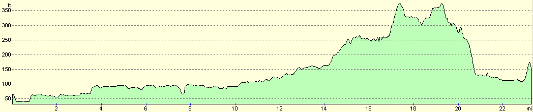
For more information on profiles, ascents and descents, see this page
Transport
There are regular train services (albeit less regular on Sundays) between Woodhouse and Retford, although it should be noted that some stations (e.g. Shireoaks) are closed on Sundays. A single ticket for the journey cost me Ł5.50. Check the National Rail timetables service for more information on rain times between the two stations.
Disclaimer
Please note that I take no responsibility for anything that may happen when following these directions. If you intend to follow this route, then please use the relevant maps and check the route out before you go out. As always when walking, use common sense and you should be fine.
If you find any information on any of these routes that is inaccurate, or you wish to add anything, then please email me.
All images on this site are © of the author. Any reproduction, retransmissions, or republication of all or part of any document found on this site is expressly prohibited, unless the author has explicitly granted its prior written consent to so reproduce, retransmit, or republish the material. All other rights reserved.
Although this site includes links providing convenient direct access to other Internet sites, I do not endorse, approve, certify or make warranties or representations as to the accuracy of the information on these sites.
And finally, enjoy your walking!
Nearby walks
| # | Title | Walk length (miles) |
|---|---|---|
| 772 | Retford to Gainsborough | 22.5 |
| 1043 | Retford to Lincoln | 23.9 |
|
|

|