Walk #772: Retford to Gainsborough
 |
 |
|
General Data
| Date Walked | 05/05/2007 |
| County | Nottinghamshire, Lincolnshire |
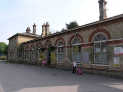
| Start Location | Retford station |
| End Location | Gainsborough Lea Road station |
| Start time | 09.08 |
| End time | 16.45 |
| Distance | 22.5 miles |
| Description | This was a pleasant walk following the Chesteffield Canal and the River Trent in a looping walk between the two towns. |
| Pack | Today I carried my 30-litre Karrimor rucksack, filled with waterproofs, a book and other odds and ends. |
| Condition | My feet have suffered slightly on this walk, mainly due to the firm ground cnditions underfoot and the fact that I had to jog for the last mile though the centre of Gainsborough. |
| Weather | The day started off cloudy with no sight of the sun, but as the morning frew on they lifted, and the afternoon was mostly unbroken sunshine. |
| OS map | Landranger number 120 (Mansfield & Worksop, Sherwood Forest) and Landranger number 112 (Scunthorpe & Gainsborough) |
 |
 |
|
 |
 |
|
Map of the walk
Maps courtesy of Google Maps. Route for indicative purposes only, and may have been plotted after the walk. Please let me have comments on what you think of this new format. For a detailed table of timings for this walk, please see the table file.
 |
 |
|
 |
 |
|
Notes
Today was forecast to be the only dry day of the bank holiday weekend, and so when I awoke early I cast about in my file of planned walks for one to do. A circular walk in Leicestershire was considered and eventually rejected, before I settled on doing this one in Retford, which would be a long walk following the Chesterfield Canal and the River Trent. My last walk in this area was this time last year, and doing this walk would open up several alternative future ones.
The drive up the A14 and A1 was nice and easy, and on schedule I parked outside Retford station - not in the expensive official car park as I did last time, but on a strip of ground opposite some houses nearby. It took me a few minutes to get my rucksack fully packed, and after my GPS had acquired the satellites I set off.
I had walked the first half-mile on a previous walk, and it was interesting to note that the housing development that I had wandered through last year when trying to find my way to the canal was all completed. There were a couple of 'For sale' signs and many 'For rent' signs on the new houses, indicating that they have probably been bought immediately for the rental market. Before too long I was passing along a little alley to reach the Chesterfield Canal - I found the alley with no problems, and I am frequently surprised that I can remember routes through areas that I have walked through once before fairly easily.
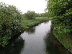
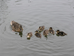
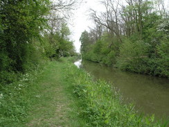
The Chesterfield Canal was joined at a lock in Retford, and after exchanging pleasantries with a couple of locals - how nice to hear good Nottinghamshire accents! - and headed off along the canal towpath. Retford looked quite pleasant from the canal side, and I enjoyed watching ducks and sucklings frolicking about, alarmed as I walked past. Overhead there was cloud and, although not chilly, it was not a warm morning, and there was a breeze that was not quite enough to cause me to put my fleece on. Underfoot there was a nice firm surface designed to help cyclists, and this sped me along the route.
Eventually a railway embankment approached from the right, before curving away once again as the canal passed a solitary lock and headed northwards towards Hayton. Once out of the town there were few people about, only a few fishermen on the banks of the canal disturbing my solitude. I was surprised to find that although the walking was easy I did not feel too positive; the miles seemed to be going slowly by, and I did not seem to be making much forward progress. There was also not much to see or report as the canal headed northwards, winding past Clayworth and Wiseton before reaching Drakeholes.
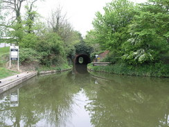
On the map the A631 crosses the canal here, but I was surprised to find that there was a short tunnel passing through Cuckoo Hill; due to the bend I could see straight through it to the other portal. I had to climb up to the B6045 road, and on the opposite side was the White Swan pub / hotel. I was already nine miles through the day, and although this was not quite halfway I decided to nip in for a break - there were not any more pubs for a fair few miles, and it looked like as good a place as any.
Inside I went into a small snug bar where there was no-one else, and ordered a pint of bitter and one of orange and lemonade. There were some people in the other bars in the pub, and the jovial noise drifted over towards me as I concentrated on listening to the radio and supping my drinks. Eventually I had to leave once again, and after saying Goodbye I headed off, and instantly got confused by which way to go to rejoin the towpath after the canal. A local pointed me down a little track that led off the road, passing a farm on the right before dropping down to the northern port of the tunnel.
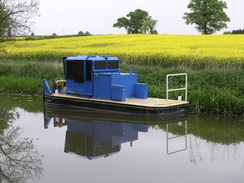
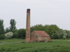
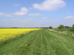
Almost immediately the towpath passed under the A631 road, which passed overhead on a high concrete bridge, and then the canal turned to head in an east-northeasterly direction, which it would keep until it ended at the Trent. I actually started enjoying this walk much more as I strolled along this stretch; a couple of narrow boats passed me, and there was more to see - occasional chimneys dominated the views, and the landscape to the north was a flat plain, green fields occasionally interspersed with yellow of oil seed rape.
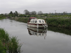
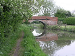
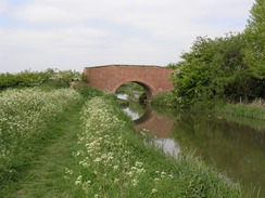
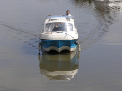
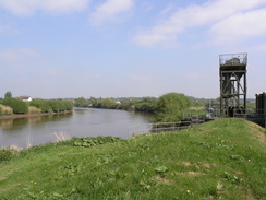
A couple of locks were passed on the way before the canal took a more northeasterly course to reach Misterton. Here the towpath became busier once again, and as the cloud had now disappeared people seemed to be out and about enjoying the sunshine and feeding the ducks. More locks were passed, before the canal passed under a railway bridge and headed arrow-straight for the last kilometre towards the River Trent at West Stockwith. There was a marina and a pub here and both were bustling; it was tempting to nip in for a drink at the adjacent pub, but as I wanted to get an early a train as possible I decided to press on.
There were two groups of people walking along the flood banks of the Trent as I started heading south, passing a factory with a little riverside wharf. After this there was no-one about, and the walk settled to a routine walk along the high flood banks. The views over the tidal river were blocked out by tall hedges to my left, but the views to the right were slightly spoilt by two sets of high power lines that slowly diverged from the river. In the sunshine it was a very pleasant stroll, and I found myself glad that I had brought my Tilley hat with me today, as it kept the worst of the sunshine off me.
The river wound around as it headed southwards, eventually reaching a set of sluice gates over a drainage ditch. There were high fences guarding this and for a moment I was concerned that I would not be able to join the footpath on the other side (in the past I have found tow adjacent footpaths cut off by such gates), but fortunately about fifty yards along the ditch there was a simple footbridge that allowed me to cross. The sun was beating down by now, but I was slightly surprised that there was little or no birdsong - I would have expected much more in such an open area.
After the drainage ditch the river went into a long, narrow loop to the east, but I continued along the flood bank that cut across the neck of the loop, as apparently had many people in the past, from the state of the grass underfoot. This soon led me on to factory buildings at Old Shipyard; a strangely-named place that I can only assume was once a shipyard. The footpath was unclear past the deserted works, but by keeping as close as possible to the river it was easy enough to make my way past piles of wood and waste metal turnings. A couple of metal steps led over the concrete floodwall and then I was out of the complex, with a good cycle path leading me southwards along the towpath.
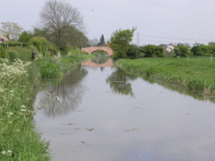
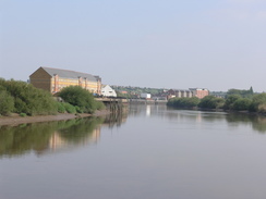
It was now a quick walk down towards the bridge over the river in Gainsborough, a pleasant walk in the sunshine, and a man was out enjoying the sunshine with his two young daughters. After passing a pub the bridge was reached; it is a fairly attractive stone structure, widened from the original, and crossed this, taking many photographs downstream along the river.
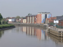
I was now faced with a decision. On the map I could see two stations in Gainsborough; one more central and the other to the south of the bridge, I had no idea which station the train was going to leave from. After looking at the map I decided that the central one looked the most likely bet, if only because of the network of lines that intersected around the town. I therefore walked along to the station through the town, and found myself rather disappointed. I had never been here before, and my only impression of Gainsborough was the famous painter. It was therefore sad to find a town which, away from the regenerated riverside, was decaying and bland. There were lots of people about on the Saturday afternoon, but most of the houses had peeling paint and grimy windows.
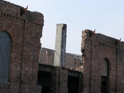
The station was not well signposted and I was forced to ask a couple of people the correct route to go. Eventually a footpath led me up past a large brick mill building, and at the top it was obvious that this was being demolished. He station was a few yards away, and the information boards that were supposed to carry information on train times had been vandalised. I therefore had no idea if I was at the correct station, and I sat down on the steps of the footbridge to wait. After ten minutes a train pulled up, and when I asked the guard it turned out I was at the wrong station - there are only infrequent trains from the Central station to Retford, and another was not due for a couple of hours.
There was only twenty minutes before the 16.49 train and the Lea Road station was a mile to the south, and so I was forced to jog through the town, knowing that I looked a silly sight with my rucksack, camera and balance pockets bouncing around. I made it with a few minutes to spare, but I was then unsure about which platform I had to be on. A man told me that he was waiting for the same train and this was the correct platform, but as a train approached I was sure that he was wrong. I ran down the steps on aching feet and passed under the subway to gain access to the correct platform; a woman with a pram told me it was the correct one. I shouted over to the other man, who sped down the steps and only just made it before the train was departing. This has never happened to me before, and the jogging has taken a lot out of me - as well as adding a mile onto the walk, my feet are in a much worse state that they had been. However this had not taken the edge off what was a fairly enjoyable walk.
 |
 |
|
 |
 |
|
Directions
This walks starts off at Retford station. Leave the station and turn right to start heading up the B6044 Victoria road; when this meets another road turn right and follow it eastwards, crossing the River Idle by a bridge and heading towards the centre of Retford. Just before a pub is reached on the right turn left along a short, narrow alley that leads to the Chesterfield canal by a lock. Cross the canal using the lock,and one on the other side turn left to start following the canal eastwards.
Follow this for a little over eight miles, until the canal reaches a portal of a tunnel under Cuckoo Hill. Here turn left and climb up to a road opposite the White Swan pub. At the road turn right; ignore a road coming in off the left, and after a few yards turn left along a track that passes to the left of a large wall. This path soon drops once more, to rejoin the canal towpath once more.
Continue along the towpath for another six and a half miles as it follows the northern bank of the canal; the going is easy as it eventually reaches the village of Misterton and ends at a marina. Just before the marina is reached, climb up onto the top of Bridge 85 and started heading southwards along the road. After a hundred yards turn left to join a bridleway that runs south along the western bank of the River Trent.
Continue south along this river bank for a little over four miles; at one stage some large metal sluice gates over a drainage ditch are reached. Here turn right and follow a track for a hundred yards along the southern edge of the ditch, before turning to the left to cross it. Once on the other side, rejoin the flood banking and continue southwards.
When Gainsborough Bridge is reached, turn left to cross the river. Where you go on the other side depends on which station you need to get to, Lea Road or Central. To get to Central, continue on eastwards along the road, crossing over Bridge Street until you reach a roundabout. Here turn left to head north along the A159 through the centre of the town. Pass a large Tescos superstore, and then turn right up a little footpath hat heads east uphill. When I walked it there was a large factory building on the left, but there is a possibility that it may be being demolished. Once the gradient slackens out, Gainsborough Central station is straight ahead.
This makes a total distance of 22.5 miles, with 462 feet of ascent and 502 feet of descent.
There are regular train services from Gainsborough to Retford; however, as I found to my cost, there are two possible stations that they could depart from. Most appear to go from the Lea Road station to the south of the town, but occasional services go from the Central station. It would be worth checking this before you set off on the walk, as it may be hard to find out once in Gainsborough.
Please note that I take no responsibility for anything that may happen when following these directions. If you intend to follow this route, then please use the relevant maps and check the route out before you go out. As always when walking, use common sense and you should be fine.
If you find any information on any of these routes that is inaccurate, or you wish to add anything, then please email me.
All images on this site are © of the author. Any reproduction, retransmissions, or republication of all or part of any document found on this site is expressly prohibited, unless the author has explicitly granted its prior written consent to so reproduce, retransmit, or republish the material. All other rights reserved.
Although this site includes links providing convenient direct access to other Internet sites, I do not endorse, approve, certify or make warranties or representations as to the accuracy of the information on these sites.
And finally, enjoy your walking!
Distances
From To Distance (m) Ascent (ft) Descent (ft) Retford station Drakeholes 9.1 151 167 Drakeholes West Stockwith 6.8 131 174 West Stockwith Gainsborough Central station 5.4 157 112 Gainsborough Central station Gainsborough Lea Road station 1.2 23 49 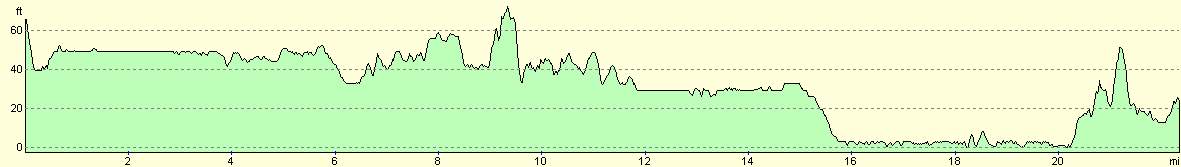
For more information on profiles, ascents and descents, see this page
Transport
Disclaimer
Nearby walks
# Title Walk length (miles) 724 Retford to Woodhouse 23.4
![]() Previous walk
Previous walk
![]() Next walk
Next walk
