Walk #771: Stamford to Peterborough
 |
 |
|
General Data
| Date Walked | 29/04/2007 |
| County | Cambridgeshire, Rutland |
| Start Location | Stamford |
| End Location | Peterborough station |
| Start time | 08.52 |
| End time | 16.05 |
| Distance | 17.7 miles |
| Description | This was a pleasant walk following the Hereward and Nene Ways between the two towns. |
| Pack | Today I carried my 30-litre Karrimor rucksack, filled with waterproofs, a book and other odds and ends. |
| Condition | I feel fine after this walk, with few problems to report. |
| Weather | It was cloudy throughout the day with no sign of the sun, but despite this it fot quite warm as the day went on. |
| OS map | Explorer number 15 (Rutland Water) and Explorer number 227 (Peterborough) |
 |
 |
|
 |
 |
|
Map of the walk
Maps courtesy of Google Maps. Route for indicative purposes only, and may have been plotted after the walk. Please let me have comments on what you think of this new format. For a detailed table of timings for this walk, please see the table file.
 |
 |
|
 |
 |
|
Notes
Sencan and I wanted to do a walk today, and after looking at the map it seemed like the walk between Stamford and Peterborough would be a pleasant Sunday stroll. I had walked this before in the opposite direction in 1999, and felt like it would be a good one, especially as it would not involve too long a drive.
Stamford looked as beautiful as ever when we arrived, the stone almost glowing despite the fact that there was cloud rather than sunshine overhead. It is a town that I have always enjoyed visiting, and In was hopeful that we may be able to get the walk over and done with so that we could have a quick look around later.
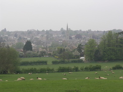
A climb along the Hereward Way took us uphill to the south, and near the top of the climb there were some reasonable views back over the town, with the spires of the churches peering over the top of the trees. A short walk along a road continued uphill, and after this a surfaced track led on into the grounds of Burleigh House, home of the world-famous horse trails. Initially the track passed a golf course, and there were a few people about at this early hour of the morning.
I was surprised by how little I could remember of this stretch of the route; it was nearly seven years since I had previously walked it, but there was little that I recognised. Unfortunately there were no views to be had of Burleigh House down the hill to the north, and for a few yards I was tempted to divert to see if I could locate it for some photos.
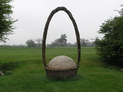
After the path left the gold course it headed across fields, and in places there were signs of the equestrian eventing course, with jumps and ditches scattered about, including a strange jump consisting of a large wooden ball with an oval branch hoop above it; I assume that the horses and riders have to go through the low hoop, which looked almost impossible to me. We had a really pleasant chat as we walked, and eventually the path left the grounds of Burleigh near a sign that stated 'no horses' - which amused me given the equestrian links of the park!
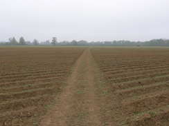
These miles were following the old Roman road, Ermine Street, and it was a pleasant albeit slightly boring walk, the path heading arrow-straight across ploughed fields. After leaving a park the Hereward Way joined a road, heading southeastwards for a few hundred yards before leaving it once again to head southeastwards alongside a wall that marked the boundary of Walcot Hall. At one point there were some gateposts leading in towards the hall, but the gates had obviously long ago been removed. When the wall ended the path continued on across fields, again heading arrow-straight, and the east going allowed us to continue chatting amiably until the path ended at a road in Southorpe.
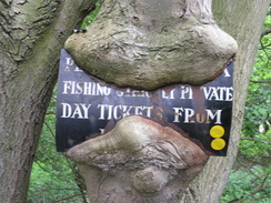
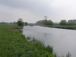
The next couple of miles were fairly boring as it heads southwards, the only things of any note being an old railway bridge (part of the Wansford to Stamford line), and a large pit on the left-hand side of the road. Eventually the road met the A47(T), and we had to very carefully follow this for a short distance; the road was busy and we frequently had to take to the verge, and it was a relief when the Way led off to the left, joining the bank of the Nene and the Nene Way. On the way there was an old metal fisheries sign that had been nailed to a tree, and the tree was actually growing over the sign, giving it a weirdly organic look.
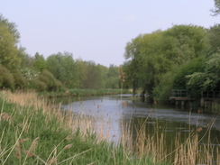
It was nice to be following the river, but it soon headed away, and at a convenient bench we stopped so that Sencan could put some tape on hotspots developing on her feet. This was surprising as she had managed a much longer walk recently with no problems, but today her feet were starting to suffer. Once we had restarted her feet felt better. And the way continued past Sutton Church before heading south along the floodplain of the river until a stretch of boardwalk was reached
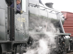
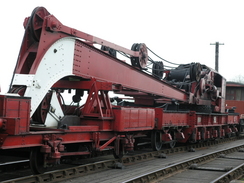
The Nene Valley Railway station at Wansford was on the other side of the bridge, so we climbed up and crossed the footpath that is alongside it; this was good timing, as just as we had finished crossing an 8F steam train came past pulling a large steam crane. It was en evocative sight, and as Sencan went to use the facilities I looked around, seeing the LNER locomotive Mayflower standing on the other side of the turntable. I have never actually travelled on the Nene Valley Railway, and I should really find the time to travel on it sometime.
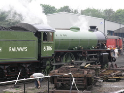
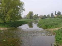
As we recrossed the bridge to rejoin the Hereward Way a Black Five crossed the bridge to run around a train, and again we stopped to watch it pass, the exhaust steam from the cylinders wafting over us. Initially the path followed the railway line eastwards, but it soon left it and field boundaries to rejoin the banks of the Nene. There were a few other walkers about as we headed eastwards, and the day was warming up and the slightly chilly breeze was lessening. It was a really enjoyable stroll, and near an old ox-bow lake the path climbed up the banks of Mill Hill, from where there were some good views along the valley.
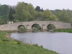
An old brick stump of a windmill, devoid of any top or sails looked quite sad, and after this the path followed the little Back Dike before rejoining the river. By this time we were in need of another break, so just before a bridge carrying the Nene Valley Railway over the river was reached we stopped at a pretty spot by the river and rested for a while. Sencan munched on a muffin and I ate a flapjack, much needed energy as we watched some rafts carrying children passing downstream past us. Eventually we headed off once again, passing under the railway and heading on as the valley side encroached towards the river, forcing us to climb slightly before reaching the beautiful Ferry Bridge, an old and historic river crossing that almost seemed to glow in the sunshine.
A short distance further on Sencan was having more trouble with her feet, so we stopped on a bench beside an area of coppiced willows to find that one of the plasters that she had put on her feet had rolled up into an uncomfortable ball. I had a spare pair of my socks with me, and as they were thicker than the ones she was wearing she changed into them, and despite the fact my feet are much larger than hers they did not seem too bad.
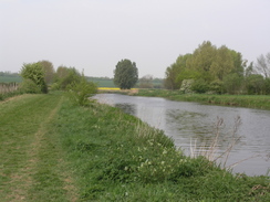
Peterborough council have done a very good job of this stretch of riverside walk, and there are many little items to pique the interest, including many wooden sculptures visible through the trees. We started to push ourselves on as we were hoping to get the train earlier than we were planning, and this proved to be a mistake as it made the situation with Sencan's feet worse. We passed Orton Lock, where canoeists were practising falling off the lockside into the lock, and headed on under the A1260 road.
After another mile of fast walking it became clearer that we would not get the train, and so we stopped off by a little bridge over a side channel and had a rest. On the way we had passed several pieces of sculpture, including a weird concrete one that I remembered from my previous walk, a sort of artistic boat structure at an angle on the bank, although we could not really tell if it was supposed to represent a boat or not. To the left there was a large and long rowing lake, and as a cruiser passed under the bridge beside us we got up and restarted the walk.
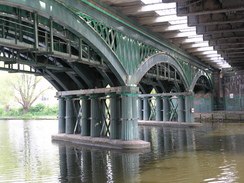
The approach into Peterborough was very pleasant, and on the other side of the river a steam train passed as it started its journey back towards Wansford. It was getting hotter, and even when we approached the very centre of the town the riverside was still neat and tidy. After passing under a series of railway bridges - including a historic cast-iron one, the oldest cast-iron bridge still in use on high-speed railway lines, and we then turned to head north towards the main-line station.
This showed us a less salubrious side of the city as we followed a main road, although even this was far better than I remembered it to be, and the spires of the cathedral were visible over the rooftops to the right. We arrived in plenty of time for the train back to Stamford, but as we bought our tickets we found that the train services had been replaced with busses. We therefore sat down in the cafe and had a drink whilst we waited, and eventually a couple of busses arrived - one heading directly to Leicester, Nuneaton and Birmingham, and the other stopping at all stations to Leicester. We got on the latter, and were surprised to find that we arrived in Stamford at the same time that the train was due to get in. It had been an enjoyable day's walk, although Sencan suffered more than she had on recent walks.
 |
 |
|
 |
 |
|
Directions
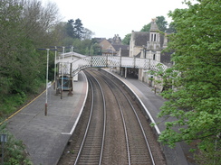
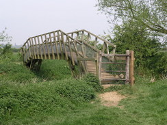
This walk follows the Hereward Way all the way to Peterborough, the second half also coinciding with the Nene Way. Leave the station and immediately turn right, following the railway line eastwards, soon passing a footbridge before heading up some steps that lead onto a road bridge that carries Church Lane over the railway. Turn right and head south up Wothorpe Road until it ends at the A43(T).
Cross the A43(T) and continue on uphill along a footpath; it reaches a stile and then heads uphill with a hedge on the left. When the footpath ends at a track turn left and walk for a few yards to the B1081 road, and then turn right ton continue uphill along this road. When a gateway leading into a golf course is reached turn left and follow the Way as it heads through Burghley Park across a golf course, the route is easy to follow and well waymarked.
After a while the Way sets on a direct course as it follows the old route of Ermine Street for about a mile until it joins a road. Head straight on along this road as it heads southeastwards for a couple of hundred yards, and when it curves to the right continue straight on along a track., with a wall to the left. When the wall ends continue straight on along fields that slowly descend until they reach a road in the little hamlet of Southorpe. Turn right her and almost immediately the road curves to the left at Grange Farm; follow this road as it heads southwards for a couple of mile, soon crossing an old railway bridge. When a road junction comes in from the left the road curves to the right and then the left, before ending at the busy A47(T) road.
Turn right and careful follow the A47(T) as it heads westwards, immediately passing over a bridge over an old railway line before heading slightly downhill. When a lay-by appears on the left enter it, and turn left to join a footpath that heads southeastwards to join the northern bank of the River Nene. It follows this for a few hundred yards before leaving the river and skirting beside an old railway line and heading along a track into Sutton.
When the track ends in Sutton turn left for a few yards towards the church, and then turn right down Lovers Lane. At the end of this turn right along a footpath that heads across a field with a hedge to the right, before thr path turns to the left to head southwards across fields towards a bridge under the railway line. Immediately after the bridge turn to the left, after which the path climbed up to join the railway embankment for as it headed wastwards for a couple of hundred yards.
The path then leaves the embankment and heads to rejoin the river; it then follows this eastwards, leaving it for short distance to climb up Mill Hill before rejoining the river. It is then simply a case of following the riverbank as it curves around towards Peterborough, passing the beautiful Ferry Bridge before reaching the centre of the town. The path passes under a series of railway bridge in the town; after the last of these turn left and leave the river, following a road that heads north before joining a main road that can be followed all of the way to Peterborough railway station.
 |
 |
|
 |
Distances
| From | To | Distance (m) | Ascent (ft) | Descent (ft) |
|---|---|---|---|---|
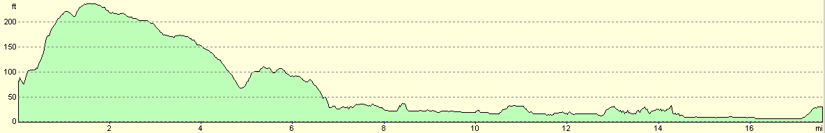
| Stamford station | Wansford station | 8.5 | 325 | 371 |
| Wansford station | Peterborough station | 9.2 | 200 | 207 |
This makes a total distance of 17.7 miles, with 525 feet of ascent and 578 feet of descent.
For more information on profiles, ascents and descents, see this page
Transport
There are regular train services running between Peterborough and Stamford; usually these are hourly, but note that there are no services on Sunday mornings.
Disclaimer
Please note that I take no responsibility for anything that may happen when following these directions. If you intend to follow this route, then please use the relevant maps and check the route out before you go out. As always when walking, use common sense and you should be fine.
If you find any information on any of these routes that is inaccurate, or you wish to add anything, then please email me.
All images on this site are © of the author. Any reproduction, retransmissions, or republication of all or part of any document found on this site is expressly prohibited, unless the author has explicitly granted its prior written consent to so reproduce, retransmit, or republish the material. All other rights reserved.
Although this site includes links providing convenient direct access to other Internet sites, I do not endorse, approve, certify or make warranties or representations as to the accuracy of the information on these sites.
And finally, enjoy your walking!
Nearby walks
| # | Title | Walk length (miles) |
|---|---|---|
| 55 | Peterborough to Whittlesey | 8.6 |
| 56 | Peterborough to Stamford | 16.5 |
| 58 | Stamford to Oakham | 16.8 |
|
|

|