Walk #725: Wivelsfield to Salfords
 |
 |
|
General Data
| Date Walked | 13/05/2006 |
| County | West Sussex, Surrey |
| Start Location | Wivelsfield Station |
| End Location | Salfords station |
| Start time | 09.54 |
| End time | 17.38 |
| Distance | 21.3 miles |
| Description | This was a varied walk, with some rather unspectacular - and somewhat dangerous - road sections and some superb woodland walking. |
| Pack | Today I carried my 30-litre Karrimor rucksack filled with my waterproofs, two litres of water, a book and various other odds and ends. |
| Condition | For the first time in six months I did not walk with strapping on my knees today, and I am glad to say that I had no significant problems, aside from a few momentary twinges from both kneecaps. About halfway through my feet were aching and were very hot, but taking my boots off for ten minutes helped cure this. |
| Weather | The day was quite warm, and started sunny before the clouds started to gather (still with occasional sunny periods) as the day went on. There was a nice, cooling breeze for most of the day, and this helped prevent me from overheating despite the warmth. |
| OS map | Landranger number 198 (Brighton & Lewes, Haywards Heath) and Landranger number 187 (Dorking, Reigate & Crawley area) |
 |
 |
|
 |
 |
|
Map of the walk
Maps courtesy of Google Maps. Route for indicative purposes only, and may have been plotted after the walk. Please let me have comments on what you think of this new format. For a detailed table of timings for this walk, please see the table file.
 |
 |
|
 |
 |
|
Notes
The best weather for today was forecast to be in the southeast, so instead of heading into the rainy north I found myself driving down the M11 and M25 to walk this walk, which I have had planned for two years since I did the Wivelsfield to Newhaven walk in 2004. I knew that a train was due to leave Salfords station at 09.16, and I drove with the intention of catching that train, so it was a relief when I pulled up at the station with about nine minutes to spare. There were no car park signs and so I pulled it up by the fence in front of the station, and went onto the platforms. The booking office was shut, so I bought a permit to travel for one pound and crossed the footbridge to wait for the train.
I had to change trains at Three Bridges, and on this train I was in a very noisy carriage, the noise coming from a group of youths who had music blaring out from a ghetto blaster. This did not bother me too much, and as they all looked tired I assumed that they had been out partying in London all night. The train eventually arrived at Wivelsfield, and I descended a seemingly never-ending set of steps to reach the road outside the station. Whilst I waited for my GPS to acquire satellites I found myself getting some strange looks, and once it had locked on I headed off up the road, slightly embarrassed.
When I had planned this walk a long time ago I had chosen a route that involved a fair amount of road walking, and as I headed north along a straight road I realised with dismay that the traffic was heavier than I expected. A Ferrari passed me twice, and the pavement soon ended as the road started going through a series of curves with narrow verges. It felt unsafe, especially when the road curved sharply to head under a narrow railway bridge. On the other side the road went through a series of more bends as it passed Folly Farm (folly being what I felt at walking along the road), and before I realised it I had reached a bridge over a railway line. This was a surprise, as my route had involved turning left along another road at a roundabout, which I had obviously missed. I backtracked slightly and could not see any roundabout (or even a junction), and could not remember having seen one as I walked. Where it should have been there was a new housing estate, and this led me to wonder if the road had been temporarily closed for the building work. Puzzled, I decided to walk on, and this marked the start of a change of route for the day that was probably for the best.
The road entered the outskirts of Haywards Heath, and I soon diverted off into a housing estate, hoping to resume a more northerly course. A series of roads were crossed before I eventually found the one that I wanted, that curved around through the southern outskirts of the town before reaching the centre via a pretty park. On the way I passed a house that had a large carved dog in the garden, a good likeness that I actually mistook for a real dog when I first caught it through the corner of my eye. The centre of the town was bustling, and there was a street café that was full, people enjoying the morning sunshine as they drunk coffee. I headed north passing the station before leaving the town northwards along the road, eventually heading under a railway bridge. After this the pavement ended, and I was forced to walk along what was another surprisingly busy road.
I frequently had to step onto the verge to avoid oncoming traffic, and this made the walk far from an enjoyable experience. I still had three miles to walk to Balcombe along this road, and as I did not fancy risking this, I decided to find another route. I stood on the verge for a couple of minutes whilst studying the map, and soon plotted a rough route that would avoid the vast majority of the road walking that I would have to do to get back on my original route. Unfortunately this meant that I would not rejoin my route for the rest of the day, but as there were some uncertain areas in that route (I was unsure if I could get through a forested area along a track) this was probably for the best.
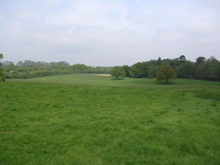
After passing an area of parkland on the left a road headed off to the right, and this proved to be thankfully far quieter. I actually started to enjoy the walk, and the road passed over a railway line before continuing on along the miraculously traffic-free road. Eventually a footpath led off to the left that carried the High Weald Landscape Trail northwards. Initially this crossed some boggy ground (especially around a gateway) before continuing across a field and through some woodland towards a rail bridge. On the way I passed a group of children with some adults who were going around noting the flowers that they were seeing, and it looked as though they were really enjoying themselves.
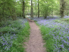
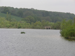
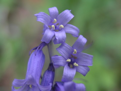
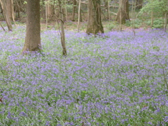
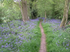
The rail bridge carried the path over a siding (originally the line carried on to meet the Bluebell Line near Horsrted Keynes), and soon plunged into River's Wood. The track through the wood was lined with vast areas of bluebells, and this made the walk spectacular, especially when the sun broke through the trees and lit them up. I knelt down to take a few photographs of some of them, and my knees creakingly gave protest when I got up once again. I really enjoyed the walk through the wood, and it was a shame when it came to an end and the path descended to a couple of bridges over streams. The path then ascended up a steep grassy hill with some nice views to the west, and this led abruptly to a pleasant view over Ardingley Reservoir.
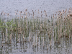
The path met the side of the reservoir by a little marina, and this was busy with people either getting ready to sail or packing up after sailing. Next came the reservoir dam, from where there were some good views to the north along the reservoir, with the water glinting in the sunshine. The dam ended too soon, and a good path headed along the eastern side of the dam, again with some good views across the water. The path ended too soon at a road, and this allowed me to cross the reservoir via a causeway before tackling a steep climb that had me sweating. Near the top there was a little lay-by, and from this there were some good views over the northern half of the reservoir, the last views of it that I would get.
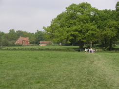
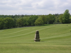
More quiet roads led me on northwards, with only one car passing me in a little under two miles. This was a welcome change from the situation earlier in the day, and I revelled in the periodic views that unfolded at times. Whilst not spectacular or particularly broad, they were good, and the lack of grandeur was more than made up for by the sunshine and sheer pastoral elegance. Eventually I left this road, taking a footpath that headed downhill before climbing up to reach the outskirts of Worth Abbey, which is now a school. Some of the buildings were fairly spectacular, albeit overshadowed by a larger, strangely-shaped structure behind. The footpath diverted away from the track through the school grounds near the tennis courts, going around a large but annoyingly smelly pond that was part of a garden dedicated to Alex Leaney, who I assume was a pupil at the school.
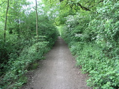
Instead of following the footpath I chose to take the track, and this led through some fairly spectacular gates before dumping me out onto a road. On the other side of the road there was a young man with camera and tripod, taking photographs of the gates, and as I passed we said Hello before I took a track that plunged into Worthlodge Forest. The ground in this forest was again amply bedecked in bluebells, and these made the stroll along the track. Highly enjoyable. Eventually I decided to stop for a break, and so after passing under some power lines and crossing a stream I took my rucksack off and sat down on the grass beside the stream, with clumps of bluebells all around me. It was a magical spot, and I took my boots off and let my feet cool off as I listened to the radio.
The rest did me some good, and once I had set off once again it did not take me long to reach the end of the track, where it meets a road. A cycle path, the Worth Way, came in from the left, and I walked along the road and started walking along a broad track that was signposted for the Worth Way and a footpath. After about a hundred yards I realised that I was going east instead of north, so I walked back, went along the road a little further and then took the correct footpath. This led northwards to Ley House, and then through an area of woodland and past a hotel (with a very full car park) to reach the A624. A road took me through the village of Copthorne, and although I fancied stopping for a drink, the pub that I passed was packed with people watching football. Instead I walked on, and fairly soon afterwards took a footpath that took me across the border into Surrey and deposited me onto another road.
This led to Shipley Bridge, and after walking along this for a short distance to cross the M23 followed another road that took me northwards. As I walked planes flew directly overhead at regular intervals, coming in to land at Gatwick Airport, only a couple of miles directly to the west. They made for a noisy but enjoyable sight, and filled up what was an otherwise pedestrian stroll to a bridge that led under a spur motorway leading to the airport from the M25. On the other side of this a path led off to the left, squeezing between a yard on the right and a fence on the left. The space for the path between the fences slowly got narrower, and eventually I had to duck down to get between shrub-like trees on the left and a barbed wire fence on the right, the latter lazily leaning in towards the path. It was an annoying but reasonably straightforward task to get past these, but later in the year when the brambles and nettles are higher it could well be a different matter.
Once past the yard the path thankfully became wider, and took me alongside the spur motorway, the noise from which intruded much more than that from the overhead planes. After about a kilometre the path ended abruptly at the B2036, and as I turned to walk along this towards Horley I reached a pub. Instantly I decided to stop for a drink, and I went into a pub where one half was packed with people watching the FA Cup Final on a large television. After ordering a pint of Spitfire and a pint of orange and lemonade I went to sit on a bench outside, and lapped up the remaining late afternoon sunshine. Clouds were starting to gather and I found myself wondering if I would finish the walk before the thunderstorms that were forecast for this afternoon arrived.
It did not take me long to drink the pints, and in a more relaxed manner I headed along the road towards the centre of Horley. There was little of real interest on the way, and this continued to be the case as the road joined the A23. As the walk was still under twenty miles I headed off to the right, passing through the middle of a Philips campus and under a railway line, before turning left along a cycle path that headed north through an area of trees, making a very pleasant walk until it reached some factory buildings on the right and, soon afterwards, a road. This led me back under the railway line and then to the station at Salfords, marking the end of what had been a surprisingly enjoyable walk, the diversions that I had been forced to make earlier in the day definitely having been an improvement over my planned route.
Directions
This walk starts off at Wivelsfield station. Leave the station and turn right, initially to follow the road eastwards for a few yards as it heads away from the bridge under the line. The road soon curves to the left, to head northwards along Valebridge Road. After a mile the pavement ends and plunges through some sharp curves under a railway bridge; it heads northwestwards for about a hundred yards before curving to resume a more northerly course. The road curves to cross the railway line on a bridge; continue on for a shirt distance past Sandrocks and then turn left, to take a path that leads down to cross Burchet Close; on the other side follow a path past some houses to reach Bolding Way. Turn left along this and then turn right to cross the car park of a health centre to reach Vale Road.
Walk along this road northwards for a few yards and then turn left along Sheppeys Road, which cuves to parallel the railway line as it heads northwards, becoming Sunnyway Drive. Eventually it curves to the right once more; join Park road and start following this eastwards. About a hundred yards before this road ends at a junction turn left along an alley that leads to Victoria Park; head northwards across the park to reach the A272 South Road in Haywards Heath. Turn left along the road for a short distance, and then cross a pedestrian crossing and head north along the B2028 Perrymount Road. When this reaches a roundabout by the station head straight on along Mill Green Road, which soon ends at a T-junction with a railway bridge on the left.
The route I describe follows roads for the next couple of miles; there is a safer route by turning right and left to follow Wickham way northwards, and when this ends a footpath leads on to river's Farm. My route turns left to pass under the railway bridge, and after this the road curves to the right to head northwestwards along Balcombe Road. When this leaves the town the pavement ends, and the road curves to take a more northerly course, passing the entrance to a park on the left before reaching a junction with Copyhold Lane on the right. Turn right along this road, and follow it as it heads eastwards, crossing a railway line on a bridge before taking a more northeasterly course.
Continue along the road for a few hundred yards from the bridge, and then turn left along a footpath that initially crosses a field before entering a small patch of woodland and continuing on to cross a small branch railway line on a bridge at River's Farm. The path continues on, plunging northwards through River's Wood, descending to emerge in a field that is crossed for a short distance to a bridge over a stream. After this there is another little bridge, and the path starts to ascend a steep hillside, before descending to meet the dam of Ardingley Reservoir by a little car park. Join a path that crosses the dam, and continues on the other side to follow the eastern bank of the reservoir northwards, winding around a couple of inlets before ending at a road.
Turn left and follow the road as it crosses the reservoir on a causeway, and then climbs steeply uphill to the northwest. At the top of the hill there is a road junction; turn right and follow this quiet road as it heads northwards for a little under two miles, passing a crossroads and heading on before reaching a footpath that leads off to the left near Paddockhurst Park. Turn left and follow this path as it initially heads downhill to the northwest, skirting some trees on the right, before turning right to plunges through the trees and joining a track that crosses a stream on what would once have been a magnificent stone bridge, but is now sadly derelict. The track emerges from the woodland and heads uphill, passing some tennis courts on the right before nearing Worth Abbey.
I found the course of the footpath on the ground to be difficult to find, so continue northwards along the track past the tennis courts, passing a pond on the left and head through a gate. To the right is the main building of Worth Abbey; here the track turns slightly to the left to head through another magnificent gate and heads north before ending at the B2110 road at an imposing gateway. Cross the B2110 road, and on the other side head straight on along a track that immediately plunges into Worthlodge Forest. Keep on this track as it heads northwards through the forest for a couple of miles; soon a Y-junction is the track is reached; take the track that veers slightly to the right to head down a slight hill. On the way the track passes under some power lines and descends to cross a stream, before slowly rising to end at a road to the east of Hayheath.
Turn left along the road as it curves to head northwestwards for a few yards; ignore the cycle path that leads off to the right, and instead continue on to a left-hand bend. Here a footpath heads off to the right, to head northwards. This skirts the edge of some trees, before crossing a series of fields to reach a track near Ley House. Here join a track that curves around past the farm buildings, and when this reaches a T-junction turn right for a few yards, and then turn left along another footpath. This path heads northwards, occasionally going through some patches of woodland before reaching the car park of a large hotel. The path skirts the hotel, and then turns left to head beside the access road to the A264 road to the south of Copthorne.
Cross the A264 about fifty yards to the east of a roundabout, and then continue on along a short section of path that ends at Brookhill Road. Follow this road as it heads northwards through Copthorne; after about half a mile the road curves to the left, and shortly after this a footpath leads off to the right. This winds around in a rough northerly direction, before rejoining the road (now called Shipleybridge Lane) shortly before the road ends at the B2037 road at Shipley Bridge. Turn left and follow the B2037 as it heads westwards, climbing up to cross the M23 on a bridge. On the other side of the bridge turn right, to start following Peeks Brook Lane northwards.
A little over a kilometre later the road passes under a spur road from the M23, and immediately after this a footpath leads off to the left, signposted for the Sussex border path. Initially this path is narrow as it heads past a yard, but it widens out slightly as it follows the road westwards before ending after a kilometre at the B2036 Balcombe Road. Turn right and start following this road as it heads slightly west of northwards into Horley. The road passes through Horley, eventually climbing to rise over a railway bridge before ending at a junction with the A23. Continue straight on along the A23 northwards, passing some playing fields on the right before reaching a junction with Crossoak Lane on the right. Turn right along this road as it passes some Philips research buildings, and passes under a railway bridge.
Continue along the road for about a hundred yards past the bridge, and then turn left along a cycle path that follows a green lane northwards for a little under a mile, passing some playing fields on the left before ending at Honeycroft lane. Turn left along this road for a short distance as it passes under a railway bridge, and on the other side turn left along Southern Avenue, which leads south to Salfords railway station, where this walk ends.
Distances
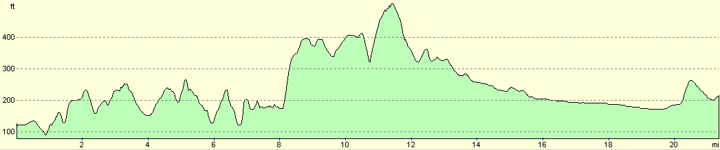
| From | To | Distance (m) | Ascent (ft) | Descent (ft) |
|---|---|---|---|---|
| Wivelsfield station | Haywards Heath | 3.8 | 322 | 285 |
| Haywards Heath | Worth Abbey | 7.5 | 948 | 617 |
| Worth Abbey | Horley | 6.9 | 112 | 417 |
| Horley | Salfords station | 3.1 | 108 | 82 |
This makes a total distance of 21.3 miles, with 1490 feet of ascent and 1401 feet of descent.
For more information on profiles, ascents and descents, see this page
Transport
There are regular train services between Salfords and Wivelsfield, changing at Three Bridges. I believe that Salfords station may be shut on Sundays; check the National Rail timetables service for more information.
Disclaimer
Please note that I take no responsibility for anything that may happen when following these directions. If you intend to follow this route, then please use the relevant maps and check the route out before you go out. As always when walking, use common sense and you should be fine.
If you find any information on any of these routes that is inaccurate, or you wish to add anything, then please email me.
All images on this site are © of the author. Any reproduction, retransmissions, or republication of all or part of any document found on this site is expressly prohibited, unless the author has explicitly granted its prior written consent to so reproduce, retransmit, or republish the material. All other rights reserved.
Although this site includes links providing convenient direct access to other Internet sites, I do not endorse, approve, certify or make warranties or representations as to the accuracy of the information on these sites.
And finally, enjoy your walking!
Nearby walks
| # | Title | Walk length (miles) |
|---|---|---|
| 596 | Wivelsfield to Newhaven | 22.7 |
| 599 | A circular walk from Westhumble to Surrey's highest point | 20.0 |
| 601 | A circular walk along the North Downs from Whyteleafe | 21.6 |
|
|

|