Walk #596: Wivelsfield to Newhaven
 |
 |
|
General Data
| Date Walked | 06/03/2004 |
| County | West Sussex, East Sussex |
| Start Location | Wivelsfield Station |
| End Location | Newhaven Town Station |
| Start time | 08.52 |
| End time | 16.49 |
| Distance | 22.7 miles |
| Description | This was a highly enjoyable walk, taking in a long stretch of the South Downs Way on the way to the coast. |
| Pack | Today I carried my 30-litre Karrimor HotRock rucksack, which was filled with my waterproof leggings, water bottle, trainers and a couple of spare shirts, together with the usual assortment of odds and ends. It weighed slightly more than usual as I also had a bit of extra kit, such as my Psion, battery charger and cables. |
| Condition | At the end of this walk my legs were fine, but my feet were aching a great deal - this has been the case on the last few long walks, and I can only out it down to the fact that I am not walking regularly and that the underside of my feet are getting soft. |
| Weather | The morning was sunny but hazy, with the views annoyingly restricted by the haze. There was a heavy and short shower at lunchtime, and after this there was some thick cloud and not much dun to be seen, although fortunately there was not any more rain until after I finished the walk. It was quite a warm day for the time of the year, and there was not any wind to annoy me. |
| OS map | Landranger number 198 (Brighton & Lewes, Haywards Heath) |
 |
 |
|
Map of the walk
Maps courtesy of Google Maps. Route for indicative purposes only, and may have been plotted after the walk. Please let me have comments on what you think of this new format. For a detailed table of timings for this walk, please see the table file.
Notes
I really wanted to get some hill walking done this weekend, and instead of travelling up to my usual walking areas of Derbyshire or Staffordshire I decided to go down to the South Downs. These are actually nearer than the Peak District, and it is an easy drive along the M11 / M25 to get there. I had planned for today to be the first day of a two-day walk, heading north up towards Croydon, but when I realised that it as not too far away I decided to save the B&B charge and drive back this evening. I arrived at Wivelsfield in good time, and found a parking spot beside a recreation ground a couple of minute's walk away. I felt that I had done enough road walking recently, so the route that I had planned for today was along named trails for the vast majority of the distance; initially the Sussex Border Path, and then the South Downs Way itself.
After doing some limbering-up exercises I left the car and walked to the railway station so that I could make it the official start of the walk. I really did not want to do much road walking today, so when I planned the walk I set out a route that headed east, passing through the strangely named World's End, to gain access to the Sussex Border Path. I passed the place where I had parked my car before heading across a playing field and gaining access to a footpath that was fairly busy with people walking their dogs on this early Saturday morning. The path became a bridleway that went past stables, and consequently there were signs of many hoof prints on the ground as I walked. Once over the B2112 I had a lovely walk southeastwards across Ditchling Common, and this was the first beautiful stretch of many on today's walk. The heather was brown and there was some gorse in flower; a sight and smell that I have loved for years.
I soon joined the Sussex Border Path and followed this south all the way to Ditchling; in places it seemed as though the official path had been diverted off slightly to the west, where there is another parallel footpath; I was definitely on the western footpath yet there were clear and obvious way markers for the named path on the stiles, so I can only assume that I was on the correct path. Just to the north of Ditchling the path passes a farm that is replete with thousands of free-range chickens; after squeezing through a gate I had to pass many of these, and the raw, guttural sound that they made was highly unusual and quite strange - I have never heard anything quite like it. Surprisingly the chickens were quite tame; I was expecting them to run away from me but instead they followed me as I walked along the path!
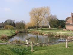
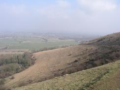
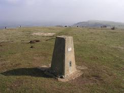
Ditchling is a very pretty village, with some attractive buildings in it. Unfortunately I could not stay to look around, and instead headed south along the Sussex Border Path (again diverted from the route marked on the map). After joining a road for a few yards I was faced with a steep uphill slog onto the South Downs that rose majestically above me; the track was easy to follow as it climbed uphill, but the ascent was steep and caused me to puff more than a little. It was well worth it, however, as he views from the top were good, although sadly foreshortened by the haze. As soon as I reached the top I felt like I was really walking, and I yomped along to the trig point at Ditchling beacon, passing a long queue of Asians on the way. This puzzled me as none of them were dressed for walking, but the answer was soon discovered - just downhill from the trig point there was a car park with three minibuses parked in it.
The South Downs Way from Ditchling Beacon to Blackcap is like a motorway, and it would be exceedingly hard to get lost on this stretch of path. The going was easy, and I made good time to the trig point at Blackcap, where I had been planning to stop for lunch. When I got to the trig point there was a couple already there, and so I sat down near to them and we had a good chat whilst I emptied my left boot of a pebble that had been bothering me for the last couple of miles. During the last couple of walks I had not taken any lunch breaks and it felt strange being stopped, and so after ten minutes I put my pack back on and headed back downhill to the South Downs Way. Blackcap is the place where the South Downs Way leaves the escarpment and heads in a southerly direction; this meant that the views were not as good as they could have been, but the going was easy along broad paths. To the north of Bunkershill Plantation I met a couple of ladies who I chatted to for a few minutes about the local area, before plunging down through the plantation, up the other side and finally downhill once more to reach the A27 road.
The A27 road is dual carriageway and was very noisy; annoyingly the noise followed me for the next couple of miles. A steep climb took me back onto the high hills once more, and the path, although not as dramatic as it had been near Ditchling Beacon, was good nonetheless, with the haze spoiling the view slightly. I could see the village of Kingston near Lewes down to my left, and the path was good as it headed southeastwards. The aching in my feet was growing, but I managed to put this to the back of my mind as I descended past a decaying Braithwaite tank to a farm. A rather good Saturday play on Radio 4 was finishing, and so I submerged myself into the end of this as I walked along the track back towards a road and civilisation.
As I headed down the hill towards the bridge over the River Ouse I was most surprised to find that the attractive Southease Church had a round flint tower. I am used to seeing round towers on churches in Norfolk and Suffolk, where there are many examples, but I had not been aware of any in Sussex. It was so intriguing that despite my aching feet I went in to have a look around the interior, which was a good decision as it is a nice, well-formed church. It proved to be far older than I was expecting - the church is first mentioned in 966, although the existing church is 12th century. I was very taken by this church, and it shoes how much bigger the small hamlet of Southease must have been in the past.
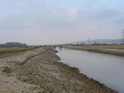
After leaving the church I headed down to the green swing bridge over the River Ouse. I had a choice here of either following the western or eastern banks of the river down into Newhaven, and I decided to follow the western bank. I therefore left the bridge behind me without crossing it, and walked past the tidal waters of the river, which was flowing swiftly out to sea. It felt strange to be walking beside tidal waters once again, so long after I finished my coastal walk, but in a strange way it was also quite relaxing. The path along the top of he flood bank ended at a road, and I followed this past the round-towered church at Pridinghoe and on down into Newhaven. The tide was very out in the town and some ships were sitting on the mud, a curiously strange sight. Further out to sea as I crossed the final bridge over the river I could see a catamaran getting ready for a trip to France, and a few yards further on I reached Newhaven Town station and the end of the walk, which came as a relief as my feet were very tired.
Directions
This walk starts off at Wivelsfield railway station, to the north of Burgess Hill. Leave the station and turn right to head east along Leylands Road for a few yards until it ends at a junction, and then turn left up another road before almost immediately turning right down Janes Lane. A short distance down Janes Lane there is a recreation ground on the right; at the toilet block turn right and cross the recreation ground diagonally to meet Manor Road. Follow this road southeastwards, and shortly after a slight bend to the right turn left to join a footpath. This footpath heads across fields near to the road; when a stream is reached you have to divert to the left to find a plank bridge across it, before resuming the original course. The path crosses the border between West and East Sussex, and there then comes a slightly complex set of junctions as the ground becomes more churned up by horse hooves.
Keep walking along a bridleway in a rough southerly direction; eventually a farm is reached where the bridleway becomes a track and firmer underfoot. The track ends a short distance further on at the B2112 road; cross the road and on the other side take a bridleway that heads off to the right, heading southeastwards along an attractive stretch of Ditchling Common. After about a kilometre the bridleway ends at a road near a depot; cross the road and once on the other side follow a farm track southwards for a few yards. Here our route joins the Sussex Border Path, which will be followed for the next few miles. The path soon leaves the track and heads south across a field to a bridge over a railway line. Cross the bridge and then turn slightly to the left; the path is initially indistinct on the ground so keep the hedge on your left as you skirt near to Clearview Farm to the edge of the field, where there is a stile.
From here the situation became slightly confused; there are a series of clear stiles across small fields in a southerly direction, although the waymarked stiles appear to follow a path a few hundred yards to the west of the one marked on my 1:50,000 OS map. The path passes through a chicken farm before eventually reaching a road in Ditchling. At the road turn right and follow it down to the B2112 road in the village. Once the B2112 is reached turn left and follow the road downhill to a crossroad in the village; at the crossroads head straight on until the B2112 curves to the right, and then head straight on down a footpath that starts in the 'vee' between the road that curves to the right and the road that goes straight on. The path skirts some houses and crosses a little residential roundabout before heading southwards across fields; skirting to the west of a little area patch of woodland and way from Park Barn Farm (note that the footpath has been diverted westwards from that marked on some 1:50,000 OS maps).
When the path ends at a road turn right along the road for a few yards, before turning left along a track that winds its way southwestwards steeply up the side of the South Downs Escarpment. At the top of the hill the gradient slackens, and a fence line marks the point where the Sussex Border Path meets the South Downs Way, which we will be following for most of the rest of the day. At the fence turn left and follow it as it heads eastwards for about a mile to the trig point at Ditchling Beacon. The path is extremely easy to follow and is like a motorway in places. Once at the Beacon continue on past the car park and drop down to the road; cross this and continue eastwards along the South Downs Way. The path is easy to follow for the next four kilometres until it nears the summit of Blackcap, where it turns to the right to head southwards (if you wish to visit the summit of Blackcap then it is only a couple of hundred yards to the east).
The South Downs Way follows a track south for about a kilometre before turning to the left and following a field boundary southeastwards for a couple of kilometres across Balmer Down. The South Downs Way then diverts ff to the right, descending steeply down to skirt through an area of woodland called Bunkershill Plantation. Once at the bottom the path climbs steeply up through the woodland, reaching the summit of the hill and then descends southwards towards the noisy A27 road. The path meets a surfaced track; turn right and follow this westwards for a short distance, passing Housedean Farm before reaching a junction with a surfaced track that leads up to the left. Climb this track to a bridge over the A27 and cross the bridge. On the other side the track turns to the left and heads eastwards, trapped between the A27 and a railway line, before an occupation bridge on the right allows the path to escape to the south.
The path slowly climbs uphill back onto the South Downs in a south-southwesterly direction for a little over a kilometre, before turning to the left and then left once more to head in a more easterly direction towards Kingston near Lewes. The path is exceedingly easy to follow as it nears the village and turns to the right to head southeastwards following the top of the escarpment; near Swanborough Hill it joins a concrete track that continues on to Front Hill before descending down Mill Hill before ending at a track, with a farm close to the right. Turn left and follow this track as it heads northeastwards up towards a road; just before the road is reached turn right along an indistinct path that heads uphill for a short distance before ending at a road junction near the village of Southease; this little stretch of path saves a little amount of road walking that would otherwise have to be done.
At the junction turn right to head south down a road for a few yards before turning left along a minor road that plunges downhill. The road passes the attractive round-towered church before reaching a metal bridge over the River Ouse. Do not cross the bridge, but leave the South Downs Way by turning right and following a footpath that follows the western flood bank of the river southwards. After a couple of kilometres the path ends at a road; turn left and follow this road southeastwards towards the village of Pidinghoe. When Pidinghoe is reached turn left and follow a quiet local road that swings through the village, passing the church before rejoining the previous road once more. Follow this southwards for another couple of kilometres as it heads into the town of Newhaven. The road eventually ends at a T-junction with the A259 North Way; turn left along this road and follow it eastwards to a swing bridge over the River Ouse. Cross this bridge, and once on the other side turn right to head down a slip road that leads to a level crossing by Newhaven Town railway station, where this walk ends.
Distances
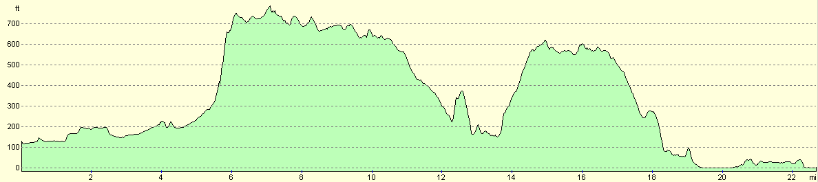
| From | To | Distance (m) | Ascent (ft) | Descent (ft) |
|---|---|---|---|---|
| Wivelsfield Station | Ditchling | 4.3 | 246 | 157 |
| Ditchling | A27 | 8.7 | 1175 | 1198 |
| A27 | Southease | 6.1 | 781 | 915 |
| Southease | Newhaven Town Station | 3.6 | 135 | 194 |
This makes a total distance of 22.7 miles, with 2337 feet of ascent and 2464 feet of descent.
For more information on profiles, ascents and descents, see this page
Transport
There are regular train services between Newhaven Town and Wivelsfield, changing at Lewes on the way. The fare cost me £5.10 for a singe ticket, and the journey took about half an hour.
Disclaimer
Please note that I take no responsibility for anything that may happen when following these directions. If you intend to follow this route, then please use the relevant maps and check the route out before you go out. As always when walking, use common sense and you should be fine.
If you find any information on any of these routes that is inaccurate, or you wish to add anything, then please email me.
All images on this site are © of the author. Any reproduction, retransmissions, or republication of all or part of any document found on this site is expressly prohibited, unless the author has explicitly granted its prior written consent to so reproduce, retransmit, or republish the material. All other rights reserved.
Although this site includes links providing convenient direct access to other Internet sites, I do not endorse, approve, certify or make warranties or representations as to the accuracy of the information on these sites.
And finally, enjoy your walking!
Nearby walks
| # | Title | Walk length (miles) |
|---|---|---|
| 298 | Beachy Head to Peacehaven | 16.7 |
| 299 | Peacehaven to Worthing via Brighton | 20.5 |
| 725 | Wivelsfield to Salfords | 21.3 |
|
|

|