Walk #595: A circular walk from Denstone to Alton
 |
 |
|
General Data
| Date Walked | 29/02/2004 |
| County | Staffordshire |
| Start Location | Denstone car park |
| End Location | Denstone car park |
| Start time | 07.30 |
| End time | 10.23 |
| Distance | 8.0 miles |
| Description | A short but very entertaining walk, taking in Alton Towers, a castle, a ruined abbey and my old school. |
| Pack | Today I carried my 30-litre Karrimor HotRock rucksack, which was filled with my waterproof leggings, water bottle, trainers and a couple of spare shirts, together with the usual assortment of odds and ends. |
| Condition | I feel absolutely fine after this walk, which is to be expected after such a short distance. My legs and feet had not suffered after yesterday's walk, which made this walk all the more enjoyable. |
| Weather | It was very cold first thing, with a thick frost on the ground, but there were very few clouds in the sky and the day soon warmed up. There was a little breeze that slightly chilled me, but this was not too bad considering the temperature. |
| OS map | Landranger number 128 (Derby & Burton upon Trent) |
 |
 |
|
 |
Map of the walk
Maps courtesy of Google Maps. Route for indicative purposes only, and may have been plotted after the walk. Please let me have comments on what you think of this new format. For a detailed table of timings for this walk, please see the table file.
Notes
I had my niece's first birthday party to go to at midday in Derby, which normally would stop me from doing a walk. However since my coastal walk it had been an aim of mine to walk on every date of the year (I only had ten days left before I fulfil this), and February 29th was one of those dates. As I would have another four years until the next opportunity to walk on this date, I decided to try and fit one in before the party. As it would necessarily be a short walk, I decided to make it a good one that would take me back to my roots - a walk in the area where I used to go to school.
Fortunately Denstone, where I planned to start the walk, was only a few miles from where my parents live, so I did not have to get up as early as I did yesterday to drive to the start of the walk. As I got out of the car at Denstone the ground was extremely frosty and it was still below freezing - a cold start to the walk. I walked past the bowls green, which has two old cast-iron mileposts from the long-abandoned Uttoxeter canal sitting in the grounds, to gain access to the Churnet Valley Trail.
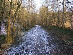
This trail follows the course of the old North Staffordshire Railway main line from Uttoxeter to Macclesfield between Denstone and Oakamoor - the line was closed in the Beeching cuts, and makes a lovely little walk through Staffordshire (and IMHO is better than the parallel Staffordshire Way). I used to go to do this walk regularly when I was at school at Denstone, and walking it for the first time in over twelve years brought back many memories. A bridge takes the path over the River Churnet and I passed my old "thinking place" - a cutting side that I used to go and sit on to think when things were getting to me, as they often do when you are a teenager!
I soon reached another notable place; my school is only three miles away from Alton Towers, and it did not take me long to find the back way in. This involved walking along the Churnet Valley Trail for a couple of miles from Denstone and then turning right, crossing a small section of the Uttoxeter Canal (a 13-mile extension to the Cauldon Canal, it opened in 1811 and was shut in 1845, when most of the route was replaced by the railway line), skirting under a security camera and then heading up a track. I must have been to Alton Towers thirty or forty times by this route, never paying. My school had sports on Wednesday and Saturday afternoons, and if I my ankle was bad and I could not play sports I would often go and visit the amusement park. When I reached the spot today I was not surprised to see that a large fence had been erected to stop such a route being exploited; this would not affect students at Denstone as the year I left Alton Towers let students buy a very cheap season ticket.
I left the railway line at the beautiful Alton railway station. This station was built in 1849 in an Italianate Villa style, and is far grander than any other on the line, and has been restored to its former glory. The reason for the grand architecture is that the station was the stop for the Earl of Shrewsbury, who owned Alton Towers, and the railway company therefore gave him a much better station than the little village really warranted. On the hillside above the station is the 1847-built Alton Castle; an imposing building perched on the valley side. This castle was formerly a girls' school, although that closed a few years ago and I have no idea what it is being used for at the moment.
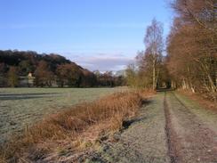
Alton village is a very nice place, and I enjoyed walking through it for the first time in many years. This village also shows the influence of the Earl of Shrewsbury, as some of the buildings are far grander than the location warrants. I nipped into a shop to buy some chocolate (a very unhealthy breakfast) before plodding on out of the village, to join a footpath that headed across fields. The only troublesome spot was a stream that had to be crossed; it took me a few minutes to find the right place to cross, but when I did find it crossing on three stones was simplicity itself.
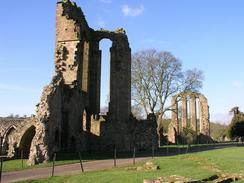
The path met a road by Croxden church, a small but elegant church that has some quite ornate carvings on the exterior for a church of its size. The reason for these carvings becomes obvious a hundred yards down the road; the stone for the church came from the ruins of Croxden Abbey. Construction of this monastery was started in 1179 when Bertram de Verdun, the lord of the manor of Croxden, gave land to Cistercian monks who arrived from Normandy, and is believed to have housed only 12 monks at any time. It took fifty years to build, the stone coming from nearby quarries at Hollington, and it was surrendered in September 1538, and all that remains nowadays are some imposing ruins. The road goes straight through the middle of the site splitting the ruins into two halves; on the smaller side there are some open stone coffins that show just how short people were in medieval times.
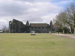
Another walk across fields took me past the farm at Pointhorne and on towards Denstone College. As I got my first views of the college from the stream at the base of coll hill (the intervening slope now having been convert to a golf course) I was surprised by the scale of the grey stone buildings. I carefully picked my way up the slope across the links and approached the college, every step bringing back memories of the five years that I spent at the school. I stood in the Selwyn quadrangle and looked at the buildings towering above me, and it made me realise just how mixed my feelings for my schooldays are - I am a very different person to who I was then. With some regret I left the quiet school buildings and walked down the road back to the centre of the village and the car. On the way I passed a large group of ramblers setting off on a walk, and I got the superior feeling you get at finishing a walk just as other are setting off. This was a truly lovely walk, and despite being less than half the length of yesterday's walk it was a far more interesting tramp.
Directions
This walk starts off at the car park outside the village hall in Denstone. Leave the car park and turn right along a road that heads past the war memorial to a junction with the B5031 road. Just before the B5031 is reached a path leads off to the left between two overgrown platforms; this is the start of the Churnet Valley Trail. Join the trail and follow it as it heads northwestwards for two and a half miles until it passes under a wide road bridge and emerges out into the splendour of Alton Station. As soon as you have emerged from under the bridge turn left and climb up some steps onto the road above. Once on the road turn right and follow the road as it climbs steeply uphill to the south and into Alton village itself.
At the top of he hill the road turns to the right to head southwards through the village; when the road splits by a strange cylindrical building take the middle road, called Dimble Lane, that heads south to the B5032 Denstone Lane. When this road is reached cross it and take a lane on the other side; after a few yards this turns to the right, and a few yards further on take a footpath that leads off to the left. The path heads between two hedges before entering a field, and then heads southwards across the fields before curving onto a slightly more westerly course. After about a kilometre a stream is reached; go down into the little gully and use three small stepping-stones to cross it.
Once on the other side of the stream turn right to follow the footpath as it heads southwestwards, roughly following the stream a short distance away to the right. After a few hundred yards a hedge is met; turn left to follow this hedge as it heads uphill to the south. The path continues on to the south before it eventually emerges onto a lane near to Croxden Church. If you wish to visit the ruins of Croxden Abbey then join the road and follow it past the church to the abbey, before returning to this point. Where the footpath joins the road another footpath leads off to the left; take this footpath as it heads in a rough southeasterly direction for about a kilometre until it meets a track that leads up to the farm at Pointhorne.
Cross the track and then immediately turn to the left to head in a more northeasterly direction, skirting to the right of some farm buildings and passing to the left of a pond before dipping down into a stream. The path then climbs up to meet a road, and on the other side of this the path descends, crossing a track just to the west of some farm buildings before dipping down to a stream. The path then heads directly northeastwards uphill, crossing a gold course before reaching the imposing stone buildings of Denstone College. Go through the grounds of the college to gain access to the main access drive. Follow the driveway past the rugby fields and then on as it descends downhill. It meets a road and curves to the right to head eastwards into Denstone village; this walk ends at the car park by the village hill, just past a distinctive wooden green shop.
Distances
| From | To | Distance (m) | Ascent (ft) | Descent (ft) |
|---|---|---|---|---|
| Denstone | Alton | 3.0 | 295 | 151 |
| Alton | Croxden Abbey | 1.9 | 187 | 220 |
| Croxden Abbey | Denstone | 3.1 | 226 | 337 |
This makes a total distance of 8.0 miles, with 708 feet of ascent and 708 feet of descent.
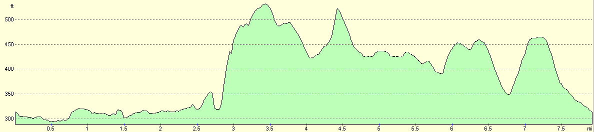
For more information on profiles, ascents and descents, see this page
Disclaimer
Please note that I take no responsibility for anything that may happen when following these directions. If you intend to follow this route, then please use the relevant maps and check the route out before you go out. As always when walking, use common sense and you should be fine.
If you find any information on any of these routes that is inaccurate, or you wish to add anything, then please email me.
All images on this site are © of the author. Any reproduction, retransmissions, or republication of all or part of any document found on this site is expressly prohibited, unless the author has explicitly granted its prior written consent to so reproduce, retransmit, or republish the material. All other rights reserved.
Although this site includes links providing convenient direct access to other Internet sites, I do not endorse, approve, certify or make warranties or representations as to the accuracy of the information on these sites.
And finally, enjoy your walking!
Nearby walks
| # | Title | Walk length (miles) |
|---|---|---|
| 24 | The Weaver Hills | 6.0 |
| 68 | Willington to Doveridge | 12.6 |
| 69 | Doveridge to Thorpe | 14.9 |
|
|

|