Walk #671: Aviemore to Derry Lodge
 |
 |
|
General Data
| Date Walked | 13/05/2005 |
| County | Highlands, Grampian |
| Start Location | Aviemore |
| End Location | Derry Lodge |
| Start time | 08.33 |
| End time | 17.29 |
| Distance | 18.0 miles |
| Description | This was a spectacular walk following the Lairig Ghru pass through the Cairngorms. |
| Pack | Today I carried my 70-litre Craghoppers WildPlaces rucksack, filled with full camping gear. |
| Condition | I feel fine after this walk, which is good considering the length that I have walked. The two small Compeed plasters have worked well on my two blisters, and they gave me essentially no trouble today. |
| Weather | The day started of foggy with the tops obscured from view, but once I started walking this quickly burned away. The morning was very sunny with few clouds and not much wind, but it clouded over in the afternoon and there was even a few minutes of drizzle. The evening however, was generally sunny, and it made for a beautiful evening to chat away the long hours of daylight. |
| OS map | Landranger number 36 (Grantown & Aviemore, Cairngorm Mountains) |
 |
 |
|
 |
 |
|
Map of the walk
Maps courtesy of Google Maps. Route for indicative purposes only, and may have been plotted after the walk. Please let me have comments on what you think of this new format. For a detailed table of timings for this walk, please see the table file.
 |
 |
|
 |
 |
|
Notes
I awoke this morning early, feeling very refreshed and relaxed. The previous evening I had bought a can of baked beans in the supermarket in the town, and I was the first person in the kitchen as I heated these up for my breakfast. I had intended to have an early start, but as I looked outside the window I could see the tops wreathed in mist, and I prevaricated, reading my book for three quarters of an hour before eventually going back to my room and packing my rucksack. The sun was just starting to shine through the mist as I set off down the road, and as I joined the B970 to head eastwards it started to make an appearance. I soon reached the campsite at Coylumbridge, where the other challengers had spent the night, and I joined the track that led south through the Rothiemurchus Forest.
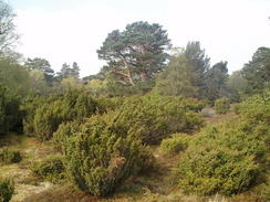
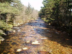
Last night someone told me that the forest was superb, and as I walked I had to agree; it is truly a fantastic place to walk through. The trees encroached the path in places, and in others there were large open spaces, covered in heather, bracken and other low-growing plants. The sheer variety of flora was amazing, and a vast contrast to the sterile and antiseptic coniferous forests that wreath so many other parts of Scotland. I took my time on the walk through the forest as the temperature slowly rose, and I took more photographs of this short stretch of path than I have over any equivalent length of path on the trip so far. I was in seventh heaven, and I crossed the Cairngorm Club Footbridge over a river with unadulterated joy. The bridge is in a fantastic setting, as it runs over boulders with the trees encroaching on either side. The path continued onwards through the forest, skirting the eastern bank of the Allt Druidh as it slowly climbed southeastwards. There was no real boundary edge to the forest as the trees slowly petered out and the open expanses grew wider, until eventually there were only one or two trees scattered about, and eventually even these stopped and I was in the open.
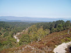
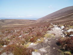
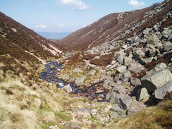
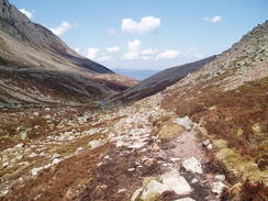
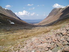
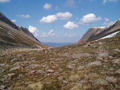
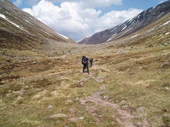
The path was easy to follow as it climbed, and although it was rough in places it was easy to make good time. The views were superb, with Aviemore clearly visible in the distance to the southeast and the hills slowly encroaching on either side. Ahead of me I could see the Lairig Ghru Pass, and as the path climbed the sides grew steeper. I stopped for a while to eat an apple and have a little rest, and as I sat my eyes scanned the views in either direction. I was in an incredibly happy mood, and as I sat off once again I felt like nothing could stop me from running up the hill. A steep, rough section followed, where the path crosses a stream and a little bluff, but after this the path entered the Lairig Ghru proper, the steep sides of the valley enclosing the path. There was a large boulder field to be crossed, and a path cut to the right to bypass the worst of the boulders. Eventually small patches of snow became visible, and before I knew it I was at the summit, with grand views visible to the northwest down the path. At 835 metres this was the highest that I had been on the walk so far, and I felt fit, and amazed that I had reached the top so quickly. A little further ahead I could see some people, and so I set off downhill towards them, passing them and eventually reaching another group who were resting a little further on.
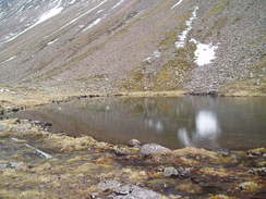
Amongst them were Rik and Sue, whom I had met in Aviemore last night and Inverness before the trip began, and I joined them before heading off again. The path passes the Pools of Dee, two small lochs that in the sunshine reflected the surrounding hillsides in a beautiful manner. As we descended the clouds started to gather, and I found this southern stretch of the Lairig Ghru Pass to be a fairly tedious plod, and it seemed to take us forever to reach the path near the Corrour Bothy. In my original plan I had intended to spend the night at the bothy, but as I was early and I was feeling fit I decided to walk on. There was one solitary tent outside the bothy, although as we walked on as the path climbed up the shoulder of a hill we started to pass other people coming in the opposite direction, heading into the hills for the weekend. As the path headed eastwards towards the Luibeg Burn I started to feel better and I walked slightly ahead of the others.
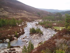
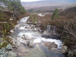
A distinct path headed clearly downhill towards the burn and I followed it down. When I looked back I could see the others heading further north, making for a bridge over the Luibeg Burn. I continued on downhill towards the burn, but when I got there I realised that there as was a ford, but no bridge. The burn was fairly full and fast-running and I did not fancy crossing it there, so I walked upstream for about a hundred yards, looking for a better place to cross. As the sides of the valley rose I gave up, and headed back up the path and worked my way across the rough moorland to the bridge, which was situated in a superb location. Here I met Rik, Mick and Sue, and we all had a rest before heading on for the last couple of miles towards Derry Lodge.
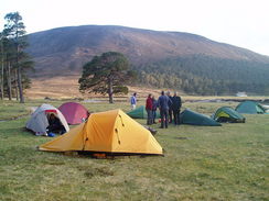
When we reached the lodge there turned out to be a couple of other tents there, and no wonder - it was a great spot for camping. I found it hard to believe that it was the first time I had erected my tent up on this trip despite having carried it so far, and I had a heart-stopping moment when I could not find my tent pegs. I soon located them under the tent and I was soon inflating my roll mat and laying out my sleeping bag. The site was truly superb, and as more people turned up as the afternoon and evening went on the atmosphere became increasingly jovial. There was a large deer on the southern side of the river, and we watched them and other wildlife as the evening drew on. Rik and Sue kindly made me a cup of tea (using dehydrated goat's milk, of all things), and before I retired for the night a local warden turned up to see if we were all okay. For a moment I thought she was going to tell us that we could not camp there, but she was very friendly and did not seem to be bothered by the twelve tents tucked away in the trees. I retired to bed fairly early, and continued to ready my book until it grew dark. It had been a superb day, and a vast improvement on the dreary walk that I had had yesterday.
 |
 |
|
 |
Directions
This walk starts off at the Scottish Youth Hostel in Aviemore. Leave the hostel and turn right to head south along the main road for a short distance, passing a petrol station before reaching the junction with the B970 road. Turn left and start following the B970 as it heads eastwards, crossing the railway line and then the River Spey on bridges. The road passes a road junction in Inverdruie before heading on towards Coylumbridge. Just before the road curves sharply to the left there is a campsite on the right; turn right along a track that heads southwards, skirting the campsite before plunging into the Rothiemurchus Forest. After a few hundred yards a fork in the track is reached; turn left along a track that heads in a more south-easterly direction through the trees. After a couple of kilometres the Cairngorm Club Footbridge over the river is reached; cross the footbridge, and once on the other side turn right to follow a footpath that heads southeastwards before curving away from the river. Take care here, as after a few hundred yards at NH938075 a path leads off to the right; take this path and follow it as it heads southeastwards through the forest.
The path skirts to the north of the Allt Druidh before leaving the forest and continuing on uphill. The path is distinct and easy to follow as it heads southeastwards. As the sides of the valley steepens a boulder field is reached; an indistinct path skirts to the right of this boulder field, missing the worst section, and leads on towards the summit of the Lairig Ghru Pass. Once at the summit the path continues south down the valley, passing the Pools of Dee as it slowly descends. Near NN985955 there is a junction with a path leading to the nearby Corrour Bothy; here the path starts to climb slightly up the flank of Carn a' Mhaim, before settling on an easterly course and descending down the valley of the Allt Preas nam Meirleach. As soon as the path starts steeply descending you have a choice; a good path leads down to a ford over the Luibeg Burn, but a dryer alternative is to head north across the moorland towards the nearby Luibeg Bridge, which is the route I would recommend. Once at the bridge cross it, and on the eastern side climb up a steep bank to gain access to a track; the alternative is to follow the bank of the stream downhill, which appeared to be a much harder walk. From here a distinct and easy to follow path heads eastwards through Glen Luibeg, which makes a pleasant walk for a couple of kilometres until a stream is reached. A footbridge leads over the stream; we camped on the eastern bank of the stream next to the footbridge, with the abandoned Derry Lodge about fifty yards away.
Distances
| From | To | Distance (m) | Ascent (ft) | Descent (ft) |
|---|---|---|---|---|
| Aviemore SYHA | Top of Lairig Ghru Pass | 9.3 | 2333 | 295 |
| Top of Lairig Ghru Pass | Corrour Bothy | 3.7 | 108 | 1056 |
| Corrour Bothy | Derry Lodge | 5.0 | 459 | 886 |
This makes a total distance of 18.0 miles, with 2900 feet of ascent and 2237 feet of descent.
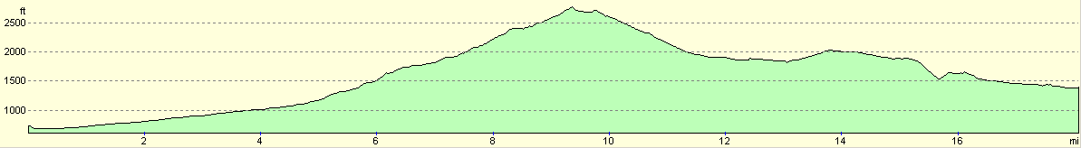
For more information on profiles, ascents and descents, see this page
Accommodation
I camped for the night by the footbridge over the burn at Derry Lodge, which turned out to be a fantastic spot to spend the night.
Disclaimer
Please note that I take no responsibility for anything that may happen when following these directions. If you intend to follow this route, then please use the relevant maps and check the route out before you go out. As always when walking, use common sense and you should be fine.
If you find any information on any of these routes that is inaccurate, or you wish to add anything, then please email me.
All images on this site are © of the author. Any reproduction, retransmissions, or republication of all or part of any document found on this site is expressly prohibited, unless the author has explicitly granted its prior written consent to so reproduce, retransmit, or republish the material. All other rights reserved.
Although this site includes links providing convenient direct access to other Internet sites, I do not endorse, approve, certify or make warranties or representations as to the accuracy of the information on these sites.
And finally, enjoy your walking!
This walk was mentioned in the following routes:
| The Great Outdoors Challenge 2005 |
Nearby walks
| # | Title | Walk length (miles) |
|---|---|---|
| 670 | Kingussie to Aviemore | 15.1 |
| 672 | Derry Lodge to Braemar | 8.9 |
|
|

|