Walk #716: A circular walk from Rosedale around Wheeldale Moor
 |
 |
|
General Data
| Date Walked | 20/02/2006 |
| County | North Yorkshire |
| Start Location | Rosedale |
| End Location | Rosedale |
| Start time | 08.45 |
| End time | 15.45 |
| Distance | 17.4 miles |
| Description | This was a slightly frustrating walk over the moorland to the east of Rosedale, which was let down by impassable forestry paths, inclement weather and boggy moorland, which combined to make walking difficult in places. |
| Pack | Today I carried my 30-litre Karrimor rucksack filled with my waterproofs, two litres of water, a book and various other odds and ends. |
| Condition | My left knee ached a little at times and my right shoulder was still sore, but not enough to be concerned about. Aside from this I feel fine after this walk. |
| Weather | Today had just about everything; sunshine, wind, clouds, rain, drizzle, hail and snow, although it did fortunately remain dry for most of the day. |
| OS map | Landranger number 94 (Whitby & Esk Dale, Robin Hood's Bay) |
 |
 |
|
 |
 |
|
Map of the walk
Maps courtesy of Google Maps. Route for indicative purposes only, and may have been plotted after the walk. Please let me have comments on what you think of this new format. For a detailed table of timings for this walk, please see the table file.
 |
 |
|
 |
Notes
I had arranged to have an earlier breakfast this morning, and so after waking up and opening my curtains to see a grey day with a few blue patches outside, I went down for breakfast at about a quarter to eight. As yesterday, the breakfast was filling and the chat enjoyable, which again delayed me slightly and I eventually started the walk about twenty minutes later than I had initially planned. It was worth it, however, and the B&B had been one of the better ones that I have stayed in. An early start to the walk was necessary as I had a four-hour journey back to Cambridge in front of me, and I wanted to make at least some of that during the daylight hours.
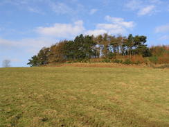
Initially I followed a couple of roads, which climbed up to skirt the sides of a little hillock with some trees on the summit to the left, before descending down steeply to cross Northdale Beck, at which point the clouds started to get darker overhead. The road climbed once more, but before long it turned to the left and a footpath continued on up the hill, although where it went was quite indistinct. I reached the top of the field to find no gate or stile, and at this point I started to hale heavily. The clouds overhead did not look as though they were going to lift, so the large stone wall gave me shelter whilst I put my coat on. I decided not to put my waterproof leggings on, the lower part of my legs being covered by my gaiters.
I had to climb over the wall to gain access to the adjacent field, and once on this unenclosed land the path was obvious; the footpath sign had pointed me into the wrong field. The path continued uphill and soon crossed a track, after which the path became more of a track as it climbed steeply, leading me up onto the moorland at Northdale Rigg. By this time the hale had stopped, and although the sun was not emerging the improved weather made me feel much better about the walk ahead of me. Once the gradient slackened another track was crossed and a narrow path headed on through the heather.
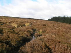
To my right a fire was being started, and I could see the flames reaching up into the sky, causing wreaths of grey smoke to be blown to the south. Before long the path disappeared, and I headed on across the moorland, heading slightly southwards of where the path should have run to get past large patches of heather. This led me down to the Hartoft Beck, which proved to be narrow enough to carefully jump across, although when I put my walking pole in to steady my jump it went in nearly halfway up to the handle; the water was far deeper than I had expected. Once on the other side I headed uphill across the moorland, angling towards wall that I could see in the distance, which I reckoned should have been on the proper path.
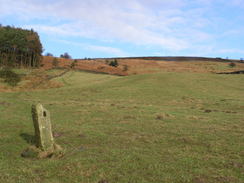
Once at the wall the going became easier as there was a narrow path that ran alongside it, although it looked more like a sheep path than a path people regularly walked along. I made good time as I strolled along, and ahead of me some strange bumps grew on the horizon in front of me. Initially these looked like the Three Howes tumuli that I had seen from a distance on Spaunton Moor yesterday, but on the map they are marked as being disused workings. Soon I was amongst them, their low rounded profiles being punctuated by more angular, smaller mounds, which turned out to be a line of shooting platforms. I wondered if these working were something to do with the old ironstone mines in the area, but whereas yesterday I had seen very little direct evidence of the ironstone mines (mounds, shafts etcetera) these were highly obvious.
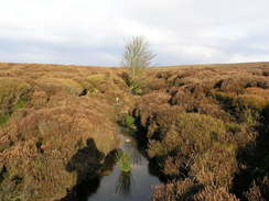
It was a pleasant little area, and the sun came out for a short period as I wandered around the mines before I suddenly stumbled upon a narrow band of tarmac that was the road I was heading for. This proved to be surprisingly busy as I strolled for a short distance along it, with four cars and a small lorry passing me before I reached the junction with the track that leads across the moor. This track follows an administrative boundary eastwards across the moors, and whilst initially it looked very good underfoot as it descended slowly away from the road it got increasingly boggy, and the going much harder. At some points the track was about twenty feet wide and boggy all the way across, with large patches of water lying on the top. In places there was evidence of attempts at improvement; an area of compacted gravel that suddenly ended where it has been eroded, or a section of wooden causey standing inaccessibly in the middle of a patch of bog. Occasionally there were boundary marker stones beside the path, engraved on two faces with a large 'E' and 1850 in a pleasing font.
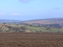
The going was quite hard, and in places I was either walking across the heather to one side or across the middle of the bog if it seemed firm enough. Consequently what should have been a good moorland walk turned out to be a bit of a struggle, and my mood was further dampened when another hailstorm started, the hail being blown directly into my face. This continued as I passed the Blue-Man-i-th'-Moss standing stone and the adjacent Wheeldale Howe Tumuli, which prevented me from getting a good photograph of either of them. This is apparently the largest standing stone on the North Yorkshire Moors, although in the rain and hail it did not particularly look like anything special. The good news was that the path suddenly became less boggy as the path rose slightly, and I managed to increase my pace as the path led me across the moorland, skirting directly to the south of an area of woodland as the sun came out and the moors took on their customary beauty, with the colours of the heather being bought out by the sunshine.
The path started to descend once more and the path became wide and boggy once more, but in the distance I cold see some sheep and, shortly after I passed them, I reached a road that runs across this lonely moor. It had been my intention to continue on across the moors for another couple of miles to the trig pillar on Simon Howe Rigg, but the walk so far had taken me far longer than I expected and so I reluctantly chose to abandon that part of the walk and headed on down the road instead. It soon descended down to cross Wheeldale Beck via a stone ford, and I saw with alarm the flood level marker for the beck that towered alarmingly above the road - do they really get floods that high in the small beck?
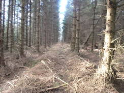
The road climbed up and was joined by some forestry on the left, before finally entering the forest proper and dropping steeply down to cross a small beck. The climb up on the other side was steeper, but after this the going was relatively flat until I reached a footpath leading off to the right. I was in two minds about whether or not to extend the walk here by walking further south and following tracks through the forest, but once I reached the path I decided to stick with my original plan, which soon turned out to be a mistake. Initially the path was easy to follow as it passed through a cleared area and skirted the side of some woodland to a track. This led me on to Low Leaf Howe House, and her things got very hard.
The house - which was deserted, although it looked as if it has been converted into some form of bunkhouse - was easy to reach, but the path onwards was soon blocked by trees that had been blown down. I slowly worked my way around these which proved to be quite difficult; the fallen trees had pulled up large dishes of earth with their shallow roots, and the resultant hollows were boggy and filled with water. The trunks were too low to the ground to go under with my pack, and too high and with too many branches to climb over. It was very slow progress, and when I reached the point where the path was supposed to turn to head northwestwards I was greeted with a large area of blow-down trees. Instead of trying to cross the area I decided to head in a rough westerly direction to the next track, taking the path of least resistance. This was difficult in itself, and the track log of my GPS shows the difficulty that I had in getting through the trees. In places I followed the gap that lay between rows of trees, but these were often blocked by fallen trees that took more time and energy to negotiate.
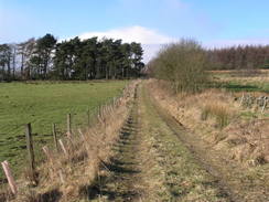
It was therefore a relief when I reached the next track, and I was faced with a choice. My plan had been to walk north to a trig pillar and the head on another path through the trees northwestwards. Not wanting to face another path through trees I decided to stick to the track, heading south towards the farm buildings at High Muffles. After the struggle through the trees this proved to be a fantastically easy walk, and the sun came out as I walked along, further improving my mood. The farm was passed and another track led me on, curving to head westwards through the trees. I took a short stretch of path downhill that took a corner off the tracks and proved easy to walk along, and then headed along another track through the trees northwards.
This was an enjoyable walk, and I was disappointed when the track emerged from the trees near Head House and skirted the hillside with trees to the right. A steep track then led down to cross Hartoft Beck once more near a farm, and on this descent I started to see the smoke from the moorland fires hanging over the valley in front of me. A surface track led from the farm up toa road, and a path then climbed up onto the final stretch of moorland for the day. Unfortunately here it started to hail and then snow, and as the path ascended In started to get slightly chilled by the icy blast of the wind. The snow was wet and was not settling, but it did take any enjoyment out of what should have been an easy and pleasant walk across the moorland.
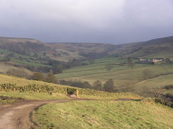
Eventually a road was reached, and as I started the descent off the moorland the snow stopped and the clouds overhead were suddenly replaced by bright sunshine. The path was fairly steep and the grass was slippery, so I took care during the descent along the path that eventually led me to a farm at The Grange. A driveway took me to a road, and I followed this for a short distance northwestwards into Rosedale Abbey, avoiding the large puddles lying at the side of the road. The road entered the village and passed the pubs that I had visited over the last couple of nights, and I made a little diversion to visit the church a little way down one of the roads. I was about to visit the local shop when I noticed the clouds gather overhead, and so instead I decided to press on along the road. It started to rain once again, and I found myself wishing that the walk was over as the road climbed up towards the B&B.
The wish was fulfilled soon enough, and the gap between my bonnet and windscreen was filled with hailstones. I switched my engine on whilst I got my rucksack off and pumped my car tyres up for the long journey back to Cambridge. Compared to the last couple of day's walking today had been far inferior, but in better and dryer weather (and with a better route through Cropton Forest) it could be quite superb. I said goodbye to the B&B and started the drive back, which turned out to be not too bad, and as I drove I found myself vowing to visit the North Yorkshire Moors again sometime this year.
Directions
This walk starts off at the Five Acre View B&B, situated a mile to the northwest of Rosedale Abbey. Leave the B&B and walk up the access driveway to the road, and then turn right to head southeastwards for a couple of hundred yards along the road until a road junction is reached on the left. Here turn left, immediately passing a farm on the right, and follow the road as it skirts the eastern side of a little knoll, before heading downhill steeply to cross Northdale Beck on a bridge. The road starts heading uphill on the other side before curving to the left; pass a building on the right and then turn right along a track that heads steeply uphill to the east. The track carries a bridleway, and when it ends the bridleway turns to the left to continue uphill to the northeast. Shortly the gradient slackens and a track is reached on Northdale Rigg.
Cross the track, and on the other side the bridleway continues on northeastwards across the moorland. It soon became hard to find on the ground, however, and I just kept on in a rough northeasterly direction as the moor heads down to cross Hartoft Beck. On the other side the moorland rises up; aim to reach a wall and keep this to the right as it heads northeastwards towards some mounds marking some old workings. The bridleway winds between the mounds, and continues on before ending at a road high on the moors. Turn left and start walking north along the road for a couple of hundred yards until a track crossing is reached.
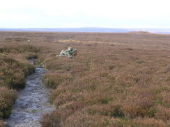
At this point turn right and start following the track as it heads eastwards across the moors. It is wide and distinct, but also very muddy, which made the going for me fairly hard. The track descends slightly and then slowly climbs, passing the Blue Man-I'-th'-Moss standing stone. Here the track becomes narrower and more of a path; it skirts the southern edge of Wheeldale Plantation and continues on across Wheeldale Moor.as it becomes narrower, but was still easy to follow. About half a mile before a road is reached the path becomes a boggy track, and this can be followed as it slowly descends down to the road.
At the road turn right and start following as it heads south, slowly descending down to cross Wheeldale Beck via a ford. The road then climb up with some woodland on the left, and a mile later the road descends to cross another stream and winds its way up the other side, entering the forest at the same time. The road heads south and passes Forest Drive that comes in from the left, and when the road curves to the left and starts heading downhill a footpath leads off to the right. Take this footpath as it heads northwestwards, crossing a couple of stiles before heading across a short area of open land to reach the corner of an area of woodland.
The path enters the woodland and starts heading west, skirting the southern edge of the woods. After a hundred yards the map shows it angling off to the right, but I found it easier to continue straight on along the edge of the woodland through the trees until a track is reached. Here turn right to head northwards along the track, and then turn left along another track that heads westwards for a short distance until Low Leaf Howe House is reached. From here the path heads westwards through the woodland before curving to head northwestwards to Leaf Howe and then west to a track; due to fallen trees I could not follow this path, and I had to force my own way through the trees in a rough westerly direction until the track is reached.
At the track turn left and follow the track southwards for a few hundred yards until a crossroads of tracks is reached immediately to the south of High Muffles. At the crossroads turn right and start following another track that initially heads southwestwards before curving to head west. After a few hundred yards the track curves to the left; here head straight on along a footpath that head downhill westwards through a gap in the trees. This ends at another track; here turn right and start following another forestry track that heads northwards through the woodland. Near Head House the track emerges from the woodland and becomes boggier as it heads on northwards with woodland to the right.
About half a mile after leaving the woodland a bridleway heads off to the left, heading westwards downhill along a walled track. Follow this track as it it passes through a farm at Low Wind Hill, where the track becomes surfaced and crosses Harftoft Beck. On the other side the track climbs uphill, soon ending at a road. Turn left along this road for a few yards and then turn right along a bridleway that climbs westwards, initially with some trees on the left before breaking out into open moorland. It is easy to follow as it heads across the moorland, and after a little under a mile another road is reached by the southwestern corner of Russell's Wood.
Turn right to follow he road as it crosses a cattle grid and then immediately turn left, joining a footpath that starts to head downhill to the west before curving to head in a more northwesterly direction. The path nears a patch of woodland as it leaves the moorland and enters some fields, and then continues on downhill until the gradient slackens, where a footpath junction is reached. Here turn right, and follow this new footpath as it heads northwestwards for a few hundred yards as it heads across fields until a farm at The Grange is reached.
At The Grange turn left and start following the driveway southwards until it ends at a road, and then turn right to start walking northwestwards along the road. After about half a mile the road enters Rosedale Abbey; follow the road through the village, passing a pub and then a hotel on the right. The church is on the left before the road leaves the village, and starts climbing uphill; a mile after the church there is a road junction; turn left down the driveway that leads down to Five Acre View B&B, where this walk ends.
Distances
| From | To | Distance (m) | Ascent (ft) | Descent (ft) |
|---|---|---|---|---|
| Five Acre View B&B | Road on Wheeldale Moor | 7.0 | 856 | 722 |
| Road on Wheeldale Moor | High Muffles | 4.4 | 502 | 374 |
| High Muffles | Five Acre View B&B | 6.0 | 792 | 1054 |
This makes a total distance of 17.4 miles, with 2150 feet of ascent and 2150 feet of descent.
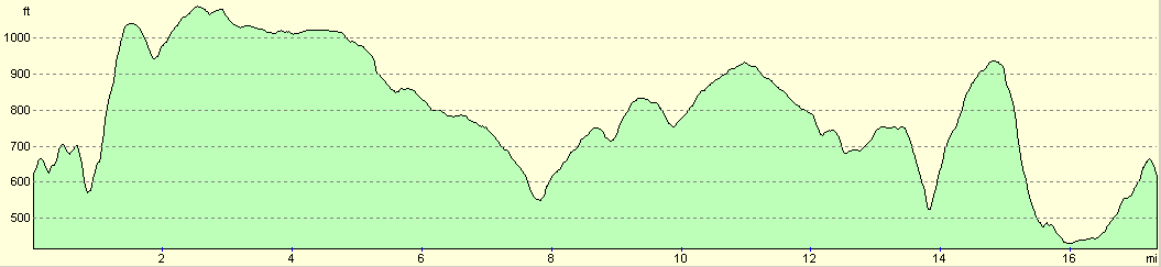
For more information on profiles, ascents and descents, see this page
Disclaimer
Please note that I take no responsibility for anything that may happen when following these directions. If you intend to follow this route, then please use the relevant maps and check the route out before you go out. As always when walking, use common sense and you should be fine.
If you find any information on any of these routes that is inaccurate, or you wish to add anything, then please email me.
All images on this site are © of the author. Any reproduction, retransmissions, or republication of all or part of any document found on this site is expressly prohibited, unless the author has explicitly granted its prior written consent to so reproduce, retransmit, or republish the material. All other rights reserved.
Although this site includes links providing convenient direct access to other Internet sites, I do not endorse, approve, certify or make warranties or representations as to the accuracy of the information on these sites.
And finally, enjoy your walking!
Nearby walks
| # | Title | Walk length (miles) |
|---|---|---|
| 715 | A circular walk from Rosedale to Hutton-le-Hole | 20.8 |
|
|

|