Walk #971: Saxon Shore Way: Hoo Flats to Twinney Wharf
 |
 |
|
General Data
| Date Walked | 09/01/2013 |
| County | Kent |
| Start Location | Hoo Flats |
| End Location | Twinney Wharf |
| Start time | 08.08 |
| End time | 15.46 |
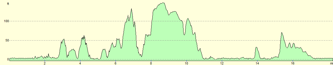
| Distance | 18.3 miles |
| Description | This was a circuitous stroll around teh Medway, passing through Rochester and Gillinham before heading out towards the Isle of Sheppey. It is a varied stroll, with some foreshore and urban walking which also feature a castle and cathedal. |
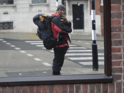
| Pack | Today I carried my Macpac Glissade rucksack containing my North Face Westwind tent, spare clothes, waterproofs, water, and enough food for two days. In total it weighed about thirty-five pounds. |
| Condition | I feel absolutely fine after this walk, and only stopped because I ran out of daylight. |
| Weather | Today started off cloudy with some drizzle in the air; however as teh day progresses, the clouds lightened until there were some clear periods. It was a warm day for January, although the breeze was chilly. |
| OS map | Landranger number 178 (Thames Estuary, Rochester & Southend-on-Sea) |
 |
 |
|
Map of the walk
Maps courtesy of Google Maps. Route for indicative purposes only, and may have been plotted after the walk. Please let me have comments on what you think of this new format. For a detailed table of timings for this walk, please see the table file.
 |
 |
|
Notes
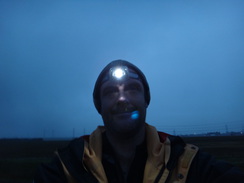
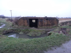
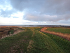
I slept well last night, and woke up to find a cloudier day. I lay in my tent and read until it started to get light before packing my rucksack. As usual I did not bother with any breakfast and was keen to set off as soon as it was light enough. My pack felt lighter on my shoulders this morning, as is often the case when starting off; it would not remain that way for too long. A track paralleled the floodbank, but this was boggy and waterlogged in places. A couple of pillboxes sat next to the track, one of which had been partially buried by the raised bank.
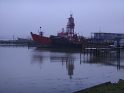
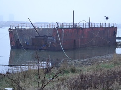
Hoo Marina Park was bustling despite the early hour, including a cafe that was open. Sadly I could not stop so early on in the short day, and so I hurried on past a whole series of boatyards and jetties. The lantern of a lightship became visible on the water, and this was swiftly followed by two others, leaving me to wonder what their collective noun is: a glistening of lightships? Most curious of all was a floating dry dock that was moored close to the shore.
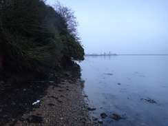
A sign at the end of the marina remarked that the path was liable to flooding, and to check tide tables. I had no access to tide tables, but decided to press on rather than walk back to take the alternative route further up the hillside. Soon a dog-walker warned me that the tide was in, and I had to wade past some bushes; fortunately my gaiters and boots managed to keep my feet dry. This left me on a narrow stretch of beach with an earthen cliff behind; not a good combination with a rising tide.
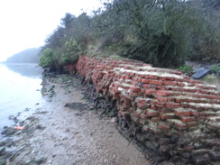
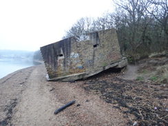
Some massive brick stonework nearly blocked the way as well; this was the remains of Cockham Wood fort. A mystery a little further on was easier to solve: a Second World War pillbox slanted at an angle where it had partially fallen off the cliff; surprisingly, this barely seemed to have changed in the ten years since I had last walked past. Thankfully I managed to reach the road in Lower Upnor without getting cut off by the tide, and was soon striding past a ships figurehead, marking an old navy training school.
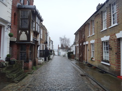
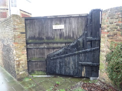
I am quite fond of this stretch of coast; it is varied with lots to be seen on the way. The path climbs near Upnor Castle, and the rails of a narrow-gauge railway line can be seen entering a large wall from a long cutting, an indication of the once-large MOD presence here. The descent down the hillside through Upper Upnor is also interesting, with many quaint houses that end at a wooden gate that was partially made out of an old shipss rudder.
Soon afterwards the trail diverts past a fenced area that warns of dogs guarding a military area. Some construction was going on within the fence, with a new building slowly springing out of the ground. A steep climb was followed by an equally steep descent down towards the Medway.
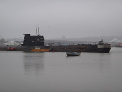
The three Rochester bridges became visible was as I descended, but my attention was taken by a strange shape moored in the water in front of them. It was a submarine, and even from this distance it looked Russian in origin. As I got closer I could see that it was indeed a Russian submarine - U475, a Foxtrot-class that used to be a museum, and may be again if the owner succeeds in his aims. Sadly the boat has seen better days and was listing slightly; it would be good to see it alongside one of the preserved UK submarines to allow a comparison.
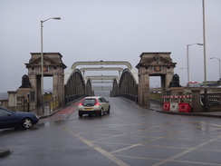
Soon I was crossing Rochester Bridge over the Medway. The bridges paintwork was immaculate and presumably they had been recently renovated. When I reached the Rochester side, it was time to divert from the trail to look for somewhere to get some water. Eventually I found a newsagents who seemed bemused by the scruffy fellow they were chatting to, but I left with enough water to last me the rest of the day.
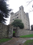
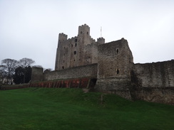
The trail follows the riverside for a short distance before climbing up past Rochester Castle, which I had never seen from such close quarters before. It has three square towers whilst the fourth is round; the latter having been rebuilt after it was undermined during a battle in 1215. It is a magnificent sight, and it is good to see a castle keep that is still in substantially complete condition.
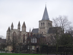
A short distance on is Rochester Cathedral, which is another magnificent structure. It is the second-oldest Cathedral in Britain, and is itself on the site of an ancient Saxon cathedral dating from the 600s. If anything the exterior appears too fresh and new, and its spire seems stylistically wrong for an English cathedral, as if it had been transported from France. In fact, the central spire and tower were only raised in 1904, although are based on the original that fell down.
The trail only skirts the cathedral before heading southeastwards through the conglomerated towns of Rochester and Chatham. It was an enjoyable walk, and one that cemented my determination to spend a few days in the area so I can explore the museums, castle and cathedral. The area has a rich naval history, and a monument on a nearby hillside was prominent. Waymarkers has been rare within the town, but the first signs since the castle became visible on some grassland near Chatham station, which marked the start of a descent back down towards the High Street.
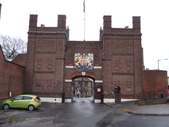
A new and sparkling, if controversial, bus station has been built in the town, after which the trail followed the road past the council offices. Off to the left was Fort Amherst, now a museum, before the path reached a rather glorious entrance gateway to Chatham historic dockyard. Another climb led me up past streets to reach an area of grassland called the Great Lines; this was an area kept clear of buildings to allow cannon clean lines of fire in defence of the dockyard below.
I stopped off at a Greggs in Gillingham to buy some snacks, and scoffed these as I walked past the station and headed towards the coast. After passing a church the signs pointed me in an unexpected direction, away from the direct route to the coast. The different route took me down streets and past a pub; I decided to nip in for a break. I did not order any food, but a pint of bitter shandy slipped down easily as I chatted to the barmaid and a customer. Time was pressing, so I soon said goodbye, hoisted my rucksack onto my aching shoulders and set off.
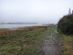
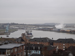
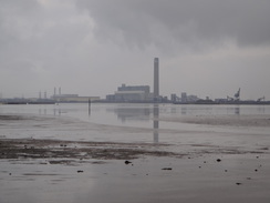
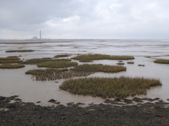
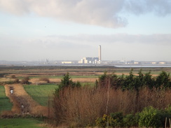
Eventually I rejoined the coastline by the Gillingham Marshes. All todays walking had not got me any further east than where I started this morning, and Kingsnorth power station was clearly visible over the water. The path underfoot was good and the views out over the estuary reasonable, but a stile proved impossible to get through with my pack. Not wanting to go through the timely procedure of taking my pack off, shoving it through the barrier and then following it through before shouldering it once more, I opted to climb over the fence alongside. Sadly I soon came across more of these barriers blocking my way. They are terrible stiles to use on a route that is a named Long-Distance Path, where people may be carrying heavy packs.
A strange machine was driving along the path in front of me, stopping occasionally to direct a large corrugated hose towards various points on the ground. The letters F.I.D.O on a cylinder on the rear of the vehicle gave me a clue about its potential purpose: to vacuum up dog droppings. Try as I might I could not catch up with it, and it eventually passed me on its return journey as I approached another of the accursed barriers.
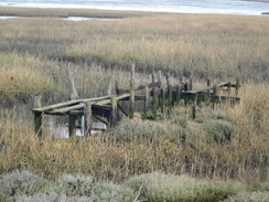
Despite this I quite enjoyed the stroll; I passed an old area of wharfage before meeting the end of a road and heading along a little peninsula. The flood banking ended at the base of Motney Hill, which the trail ascended along a road. Near the entrance to a sewage works, the trail left the road and descended back to the flood banks on Otterham Creek. On the walk down the creek I chatted to a local man and realised that I was not going to reach the place I had been planning to camp. It was supposed to be a 22-mile day, but I was going to run out of daylight well before then.
The trail passed Otterham Quay before climbing up to follow a road towards Upchurch. A bustling village pub looked warm and inviting, but I still wanted to get as many miles done as possible before dark. This area of Kent contains many orchards and I walked through a couple as I bypassed Upchurch and headed towards Ham Green. On my coastal walk I had headed along a road that is nearer to the sea, but the Saxon Shore Way cut through another orchard. Eventually a road led back down to a floodbank.
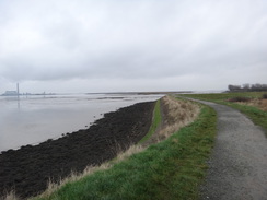
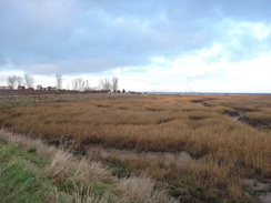
From this point on, I was looking out for somewhere to camp. The area where the path met the sea was dominated by a small boatyard, so instead of stopping I continued along the seawall. Sadly the area at the inland base of the floodbank was waterlogged and unsuitable for camping, forcing me on. Boats were moored at Twinney Wharf, and a few hundred yards further on I found what I guessed was the best spot before I reached Lower Halstow; there was little chance of finding a spot on the trail beyond there before dark fell.
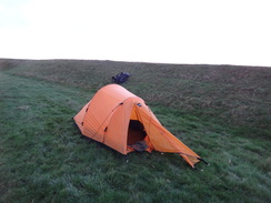
The spot was a grassy verge at the base of the bank, separated from an adjoining field by a ditch. Some houses were visible in the distance, and I waited a few minutes for dusk before erecting my tent. A dog walker gently interrogated me about what I was doing, but he did not object and so I continued attaching the flysheet. As darkness fell I crawled undercover and started reading; soon the temperature dropped and a freezing mist hung over the surrounding fields. It was disappointing not to get as far as I had hoped, but it had been an enjoyable days walk nonetheless.
 |
 |
|
Directions
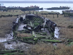
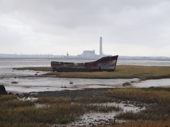
This walk starts off at TQ797717, beside the flood bank at the northern bank of the river Medway about half a mile to the west of Kingsnorth Power Station. Follow either the grassy top of the flood bank, or the rough track at its base as it winds around in a rough westerly direction for about three-quarters of a mile, passing a few anti-tank blocks, a couple of pill boxes and a series of old boats rotting away on the mudlfats.
At TQ787714 the trail goes through a clapper gate beside a field gate to enter a marina; here a diversion path for high tides head inland towards Hoo. If the tide is high, you would be wise taking the alternative route, as the one described here can be impassable.
Pass an industrial shed on the left, and then turn half-left to join a narrow path that runs between palisade fences through the marina. It crosses a concrete track, and the fences take the path along the other side. The path broadens out to become a track that ends at a T-junction with another track. Cross the track ahead, and immediately turn left to join another footpath that runs between more fences. After a few yards this turns sharply right and continues on, before emerging out onto another track; turn half-left to follow this track westwards past boatyards.
As the track curves away to the right, turn sharply left towards some gates and the water, and then right to join another path that runs between fences before going through a gate to reach an area of grass that is used as a boat store. Head straight across this and go through a clapper gate to join a path that follows the edge of the marina, passing a car park on the right.
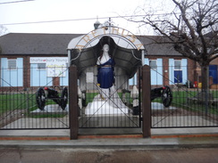
Go through a gate to leave the marina and drop down onto the foreshore. Take care; if the tide is high then turn back and take the inland route. The path passes some large red brick walls belonging to an old fort that are slowly being eroded by the sea, and continues on past a wooded hillside to the right. After a third of a mile some slipways from a sailing club are reached; carefully cross these and continue along the foreshore for another third of a mile until a boatyard is reached. Cross some more slipways, and on the western side climb up off the foreshore to join a path that parallels the water with a fence on the right. The path curves to the left to take a southwesterly course. At TQ762712 go through a clapper gate to join a road; head along this. Shortly after passing a figurehead of Arethusam on the right, the road curves to the right.
Do not follow the road, and instead head straight on along a surfaced path that parallels the shore; it passes through a small car park before continuing on for a few yards to end at Upnor Road opposite the Pier Hotel. Continue along the road; as it curves to the right turn left to join a footpath that enters some trees. Climb some steps with a large wall to the left. At the top, follow the wall on the left with a road away to the right. The path eventually merges with the road near the entrance gateway to Upnor Castle. Pass the gateway and continue to reach a road junction at TQ757705.
Turn left to follow the road south for a few yards; just before the Kings Arms pub is reached, turn left down a cobbled road through Upper Upnor. Follow this road as it heads downhill to the east through Upper Upnor. At the bottom of the hill turn right and descend a slope that joins the foreshore. The path soon curves slightly to the right and joins a fence on the left that protects a military base. Soon a track is reached; pass a gateway through the fence and then continue on uphill, following a fence on the left. When the fence ends, continue along the path as it parallels the A289 dual carriageway. The path curves to the right and then left to reach a dual carriageway immediately to the north of a roundabout at TQ749700.
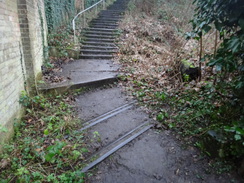
Carefully cross the road using the pedestrian crossing, and join a cycle path on the other side. This immediately curves to the left; after this turn right to climb some steps to join a surfaced path that heads west across scrubland; it emerges out through a clapper gate onto a road. Turn left to follow the road uphill to the southwest. As the road curves to the right, continue straight on along a narrow path that continues climbing, before cresting the summit and starting to fall steeply between fences. The path curves to the left before going through a cycle barrier to reach a road at TQ744695.
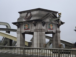
Cross the road and continue straight on along another road called Riverside. This immediately curves to the right and crosses a lock that was once the sea lock of the Thames and Medway canal. Continue along the road for a third of a mile from the lock until the Rochester bridges are reached. Pass under the rail bridge and then carefully cross the approaches to the two road bridges to reach their northern side. Turn left to cross the southernmost bridge, with the river down to the right.
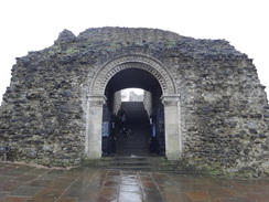
At a crossroads on the other side of the bridge at TQ741687, turn right to follow a road called Esplanade south; this soon passes Rochester Castle on the left. An area of grassland starts on the right; continue on and then take a sloping path that leads up to the left. This meets a road called Bakers walk; join this and follow it as it passes the castle keep on the left, curving slightly to the right and then left before reaching a road junction. Turn left down the a road, with grass and the castles curtain wall off to the left. When a wall on the right ends, turn right to approach Rochester Cathedral at TQ742685.
The road immediately angles to the right, passing the cathedral on the left. It then curves to the right to head towards a stone archway over the road ahead. Just before this is reached, turn left along Manor Canon Road, which soon curves to the right. When the road ends, go through a gap in a wall ahead to enter some parkland. Follow a wide path southeastwards diagonally across the park, aiming for the far corner. The path emerges out onto a road junction. Head straight on for a few yards to a second road junction.
Here turn left to follow the B2097 East Row southeastwards. When the road curves to the left, turn right and immediately left to follow a narrow road called Gravel Walk. This becomes a path that ends at King Street. Turn left along this road for a few yards until it ends at a T-junction with Delce Road. Turn right along the road and then immediately left up a short alley that leads onto the A2 Star Hill road. Turn right up this road to reach a roundabout at TQ746679.
Carefully cross the roundabout to reach a gap in a low wall that leads into a park and join a surfaced path. At a junction turn right to head back towards the road, and then left along another surfaced path that runs along the top of a bank, with tennis courts below. When the bank ends the path curves slightly to the left and heads downhill to reach a rough road. Turn right and follow it as it heads uphill, passing the University for the Creative Arts on the right. When the road ends at a T-junction with Fort Pitt Hill, turn sharply to the right to follow it uphill.
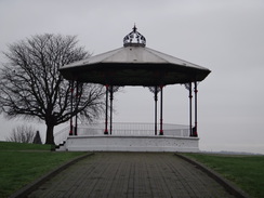
After a short distance turn left up a couple of steps to join a surfaced path that heads through another park. This approaches, but never joins, a road on the left; when the path ends turn left to head downhill along a surfaced path through the park, passing a bandstand away to the left. When another path is reached, turn right down a slope and a few steps to reach the A2 at TQ753678.
Carefully cross the road, and on the other side head straight on down a road called Hamond Hill; this ends at a T-junction with the High Street. Turn right along the High Street and then take the first road to the left, Medway Street. This soon curves to the right before ending at a T-junction. Turn left to reach the new Rochester bus station. Follow the road as it curves to the right past the bus stops, and at a T-junction turn left to join the A231 Dock Road.
Follow the road as it climbs up a slight hill; it soon curves to the right. When an imposing gateway into Chatham Dockyard is reached on the left, cross the road using the pedestrian subway and take some steps leading uphill to the right. The steps lead to a sloping surfaced path and more steps that lead between blocks of flats. The path becomes a road that continues uphill before ending at a T-junction with another road. Head straight on along Garden Street, passing The King George V pub on the way. When the road ends, cross a road ahead and continue on along a road called Sally Port. This curves to the right to take a more southeasterly course, passing playing fields on the way. Go past a vehicle barrier as the road becomes a path that eventually emerges out through another vehicle barrier onto Marlborough Road at TQ768682.
Turn left to follow the road as it heads downhill, with the playing fields on the left. After a quarter of a mile a road junction is reached; turn right up the High Street. As the road curves to the left, continue straight on along the pedestrianised High Street until Gillingham railway station is reached at TQ774683. Carefully cross the road ahead and head down Railway Street, passing the entrance to the station on the right and then paralleling the tracks. Take the first road off to the left, Kingswood Road, and follow this as it heads north. After a sixth of a mile the road curves to the left, paralleling a railway line in a cutting below to the right. Soon afterwards, the road ends at a T-junction at TQ776688.
Turn right along the road, immediately crossing the railway line on a bridge. The road immediately curves slightly to the left as it descends; 150 yards after the bridge turn right past a cycle barrier to join a surfaced path, following a fence on the left. The path heads east, dropping slightly before climbing steeply. Pass a cycle barrier and then a school on the right, before passing a vehicle barrier to become a road which ends at a T-junction with Church Street at TQ782688. Turn left down the road for a few yards, and then right up another road that ends at the gateway leading into a churchyard.
Go through the gate and follow a surfaced path that leads past the church on the left. The path curves slightly to the left before ending at a bend in Grange Road, Head straight on along the road for a few yards before turning left through a gateway that leads into a park. Head north along a surfaced path, with the church away to the left. The path curves slightly to the left and when it ends beside house gable, turn right for a few yards to reach the end of Layfield Road.
Walk east down the road; at a T-junction turn left down Court Lodge Road for a few yards, passing the Ship Inn on the left. When the road soon ends go past some bollards and turn right to join a pavement beside the A289. Cross the end of a road and continue along the dual carriageway until a pedestrian crossing is reached on the left. Use this to cross the road, and then immediately turn left along Waterside Lane. When the road ends at a T-junction, continue straight on along a path that heads between houses ad through a cycle barrier to meet a riverside walkway at TQ788691.
Turn right along the walkway; go through a cycle-stile and continue along a waterfront road called Owens Way that passes houses and then industrial buildings on the right. This road then curves to the right and becomes wider as it curves to the left. As it swings to the right once more to approach the main road, turn left along a surfaced path that follows a fence on the left. The path soon curves to the left and approaches the foreshore once more. When it ends, climb a couple of steps and turn right to join a good path along Gillingham Seawall at TQ792690.
Follow the path along the seawall; it passes a country park and a little island called Horris Hill, which is connected by a causeway to the mainland. Sadly there are many narrow squeeze stiles to negotiate as the path continues along the shore. After 2.5 miles it passes Blow Wharf (now disused) and approaches a road and car park at TQ821675.
Just before the road is reached, turn left along a good path that squeezes between the road and shore; after a while it climbs up onto a flood bank. 0.4 miles after the car park cross a stile beside a vehicle barrier and drop down to meet the road. Follow the road up Molney Hill; at the top of the hill it passes a few houses on the left, and after a quarter of a mile the road approaches the gate leading into a sewage works.
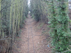
Do not go through the gate, and instead turn right through a clapper gate to join a path that immediately curves to the left through scrubland. The path soon curves to the right and heads downhill, following a chain-link fence on the left; it crosses a footbridge over a ditch and then climbs up steps to reach the top of a floodbank at TQ830681 beside Otterham Creek. Turn right and follow the floodbank as it winds around in a rough southerly direction for about two-thirds of a mile until the end of the creek is reached. At the end, turn left to follow a good path that heads southeastwards with a palisade fence and factory off to the left. After a fifth of a mile it joins a track that becomes a concrete track that ends at Otterham Quay road at TQ831670.
Turn left along the road; as it curves to the right turn left up a footpath that climbs steeply up a hillside, following a fence on the left. It skirts a garden wall on the right; almost immediately afterwards the path emerges into an orchard. The path heads diagonally across the orchard, but it may be best to walk around the edges to reach the opposite corner. Once there, go through a squeeze stile in the hedge to reach a track. Turn right down this track for a few yards to reach a bend in a road at T834673.
Continue straight on along the road as it heads east-northeastwards towards the village of Upchurch; on a right-hand bend after 0.4 miles, turn left across a stile and down some steps to enter a yard. Follow a track that passes a vehicle barrier and then a house on the right. The track becomes rougher as it heads past fields before becoming better quality once more.
Shortly after it curves to the left towards a lake, turn right through a gap in a fence to reach a clapper gate into a field. Head straight across this field aiming for a corner ahead; go through a clapper gate to reach Poot Lane at TQ844681. Turn left to follow the lane north for 200 yards, and then turn right to join a path that runs between fences. The path and fences curve to the right to reach a clapper gate. Cross a paddock and go through a second clapper gate and head on to a squeeze stile. Continue past some short sections of hedges to enter an orchard; head through this. The path becomes a track that emerges through a stile beside a gate onto Poot Lane at TQ846688.
Turn right along Poot Lane, and immediately after passing a house on the left, turn left along Shoregate Lane. Follow this as it heads northeastwards for a quarter of a mile until a little boatyard is reached at TQ849691. At a gateway that leads into a boatyard, turn right to join a footpath that follows a flood bank in a rough southerly direction. After 0.4 miles the bank curves to the right inland; drop down to the left off the bank and head across a boggy area to reach a track and a few boats.
Walk past the boats and rejoin the flood bank. After another third of a mile Twinney Wharf is reached at TQ853681; cross the track leading to the wharf and head on along the flood bank. Pass through a clapper gate that leads onto an open area of floodbank; this walk ends at TQ856680.
 |
 |
|
Distances
| From | To | Distance (m) | Ascent (ft) | Descent (ft) |
|---|---|---|---|---|
| Hoo Flats | Rochester Bridge | 5.2 | 256 | 256 |
| Rochester Bridge | Gillingham Marshes | 5.8 | 489 | 492 |
| Gillingham Marshes | Twinney Wharf | 7.3 | 220 | 220 |
This makes a total distance of 18.3 miles, with 965 feet of ascent and 968 feet of descent.
For more information on profiles, ascents and descents, see this page
Accommodation
I camped for the night in the lee of a flood bank near Twinney Wharf at TQ856680.
 |
 |
|
 |
 |
|
 |
 |
|
 |
 |
|
 |
 |
|
 |
 |
|
 |
 |
|
 |
 |
|
 |
 |
|
 |
 |
|
 |
 |
|
 |
 |
|
 |
 |
|
 |
Disclaimer
Please note that I take no responsibility for anything that may happen when following these directions. If you intend to follow this route, then please use the relevant maps and check the route out before you go out. As always when walking, use common sense and you should be fine.
If you find any information on any of these routes that is inaccurate, or you wish to add anything, then please email me.
All images on this site are © of the author. Any reproduction, retransmissions, or republication of all or part of any document found on this site is expressly prohibited, unless the author has explicitly granted its prior written consent to so reproduce, retransmit, or republish the material. All other rights reserved.
Although this site includes links providing convenient direct access to other Internet sites, I do not endorse, approve, certify or make warranties or representations as to the accuracy of the information on these sites.
And finally, enjoy your walking!
Nearby walks
| # | Title | Walk length (miles) |
|---|---|---|
| 176 | Gravesend to Rochester | 17.2 |
| 179 | Sittingbourne to Faversham | 13.9 |
| 281 | Stanford-le-Hope to Wennington | 16.9 |
|
|

|