Walk #281: Stanford-le-Hope to Wennington
 |
 |
|
General Data
| Date Walked | 29/11/2002 |
| County | Essex, London |
| Start Location | Stanford-le-Hope |
| End Location | Wennington |
| Start time | 08.02 |
| End time | 14.27 |
| Distance | 16.9 miles |
| Description | This was a walk that may well have been boring for many people, but I found it very interesting, if not particularly scenic. |
| Pack | Today I carried my 30-litre Karrimor HotRock rucksack, which was filled with my packed lunch, waterproof leggings, water bottle and a couple of spare shirts, together with the usual assortment of odds and ends. |
| Condition | Yet again I feel absolutely fine, and could easily have walked further if the need had arisen. |
| Weather | Today's weather was predominantly cloudy with only occasional sunny periods to be seen. Fortunately there was not any rain during the day, despite some of the clouds being quite black. It was also a quite warm day, and I managed to keep quite warm, as there was not much wind to cool me down. |
| OS map | Landranger number 177 (East London, Billericay & Gravesend) |
 |
 |
|
 |
Map of the walk
Maps courtesy of Google Maps. Route for indicative purposes only, and may have been plotted after the walk. Please let me have comments on what you think of this new format. For a detailed table of timings for this walk, please see the table file.
Notes
This was an interesting walk, most of which was beside the River Thames. This walk would not be everyone's cup of tea, but I enjoyed it in a very strange way. It mixed pre and postindustrial landscapes ell, all intermingled with the unceasing flow of traffic along and across the river.
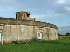
I found the nineteenth century Coalhouse Fort very impressive, and spent a few minutes walking around it. The stonework is on a very impressive scale, and I could image in it and it's partner on the south side of the river at Cliffe in action, firing over the river. I wanted to find out more about the fort, but almost amazingly there were no information boards explaining about the fort. There was a little notice on a door saying that the next guided tour of the fort was going to be in March 2003, but that was hardly of use to me. Fortunately I know a good website which contains detailed information about all the Thames forts, so I can link to that site once the walk has finished. It is a real shame that the local council have seen fit to provide a nice car park for the local dog walkers but cannot provide information about the fort itself.
The walk beside Tilbury power station was beside a large concrete wall, which protects the power station from high tides. This wall was covered in graffiti and daubings, some of it stupid and inane but some of it fairly thought provoking, which is highly unusual for graffiti. Some of it had obviously been there for some time as there were references to the NUM, mods, 1988 and Rocky III, all of which are mid or late eighties references. I am loath to call graffiti artwork, but some of the paintwork was actually very good, at least to my untrained eye.
Shortly afterwards I passed Tilbury Fort, which has a lovely entrance building. This is an English Heritage site, and is open to the public for most of the year. This is exactly the sort of place that I would love to stop and look around, but my schedule really does not allow such stops which is a shame. I spent nearly five years in London and never really explored this side of London, which was something I perhaps should have done. The fort is an impressive complex of moats, ramparts and walls, which was mainly constructed in the late seventeenth century. It stands where Elizabeth the first stood to review the army that was assembled to face the Spanish Armada in 1588. Shornemead Fort, its partner fort on the other side of the river, could work with it to seal the Thames with crossfire in a similar way to Coalhouse and Cliffe Forts. I visited the site of Shornemead Fort on a walk earlier this year and it has mostly been demolished, so it is nice to see what it originally would have looked like.
I had to make a diversion inland around Tilbury Docks, as there was no right of way marked on the map and I did not want to waste time trying to find if there was one. This meant that I walked a fair few miles away from the river, but I managed to find even this interesting.
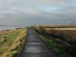
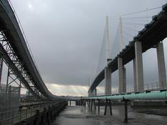
The walk westwards from Grays to Purfleet Station was along the riverbank, although for long periods I could not see the sea as there was a big concrete wall between the river and me. This stretch of the walk was through a very industrial area, but I found it a fascinating walk, with factories to my right and the river to my left. I passed the largest electricity transmission tower I have ever seen, which is one of a pair that carry cables over the Thames, and passed right under the approach viaduct to the cable-stayed Queen Elizabeth II'nd bridge at Dartford. I have always loved this bridge (which was under construction when I was a Geological Engineering student at Queen Mary and Westfield College in Mile End), so it was quite nice passing right underneath it and seeing details of how it was built (yes, I am that sad). Right next to the bridge are the ventilation shafts for the tunnel, which now carries anticlockwise M25 traffic whilst the bridge carries the clockwise traffic. Technically the QEII bridge is the first crossing over the Thames, but I am not sure if there was a footpath or it, and I want to walk as far as Westminster anyway.
Tomorrow I am getting to an interesting section of the walk as I enter the East End, an area I lived and worked in for a few years. I am very much looking forwards to this, and I am hoping that the forecast rain will hold off for this stretch.
Directions
This walk starts off at the Walton Hall campsite, which is to the northeast of Linford in Essex. Leave the campsite and turn right to walk southwestwards along Walton Hall Road for a few hundred metres until it ends at a T-junction. Be careful when walking along this road as there is no pavement and the road has blind bends, coupled with many lorries that use this road.
At the junction turn left to head south-eastwards along Tilbury Road, passing through Linford and East Tilbury before reaching the imposing Coalhouse Fort. Pass to the right of the fort and continue on along a tarmac path to the river at Coalhouse Point. At the river turn right to continue on westwards past East Tilbury Marshes. The path soon becomes unsurfaced and slightly muddy, but the Tilbury power station is soon reached. At the power station the path runs along the bottom of a concrete river wall, passing under a large conveyor passing out into the river.
The path leaves the power station behind before reaching the area around Tilbury Fort. Walk along the wall beside the fort and continue past it, where Fort Road runs parallel to the wall for a short distance before it ends near the Tilbury Ferry buildings on the left. Pass in front of the ferry buildings until a roundabout with the A1089 Ferry Road is met. Turn right to head northwards along the A1089, which runs past the entrance to Tilbury Docks on the left.
Follow the road past Tilbury Town Station and becomes dual carriageway. It rises up to climb over the railway line and descends down to a roundabout, which leads off to an industrial estate on the left. Continue straight on northwards along the A189(T) along the pavement. After a kilometre the pavement leaves the road and ends at a local road. Turn left down this road for a few yards before it ends at a T-junction with the A126 road. Turn left to walk westwards along the A126 into the town of Grays. After about a kilometre turn left down Bridge Road, which heads south, crossing over the railway line and then head right down Argent Street.
Follow this road as it heads westwards, passing to the left of three tower blocks before reaching some more modern housing. Continue along this road and at the end turn left to join the seawall. At the seawall turn right and walk westwards along it as it slowly curves to head southwestwards, passing under a massive electricity transmission tower before reaching Stone Ness. Here the path curves around to head northwestwards through an industrial area, passing under the approach viaduct to the Queen Elizabeth II'nd bridge and past the ventilation shaft for the Dartford Tunnel. The path continues beside the river wall, this time on the inland side, until it gets near to Purfleet where it leaves the wall and starts to head inland along a narrow and dinghy path which comes out by the station on the A1090 road.
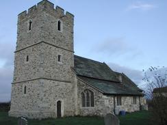
Turn left along the A1090 road and follow it as it curves around to head northwards crossing a railway line on a level crossing before ending at the A1306 road. When I walked this route work on Phase 2 of the Channel Tunnel Rail Link was ongoing, so the road layout in this area could well change. At the A1306 road turn left and follow it northwestwards to a roundabout with the A13(T). This stretch of road does not have a pavement, but I managed to walk okay and the verge. At the roundabout continue straight on over the A13(T) bridge to another roundabout, and continue straight on down the A1306. There is a pavement on the left-hand side of the road. After about half a kilometre a junction with the B1335 Wennington Road is reached on the left. Turn left down this road to head westwards into Wennington, passing the fire station before reaching the attractive church, where this walk ends.
Distances
| From | To | Distance (m) | Ascent (ft) | Descent (ft) |
|---|---|---|---|---|
| Campsite in Linford | Grays | 9.8 | 125 | 144 |
| Grays | Wennington | 7.1 | 154 | 138 |
This makes a total distance of 16.9 miles, with 279 feet of ascent and 282 feet of descent.
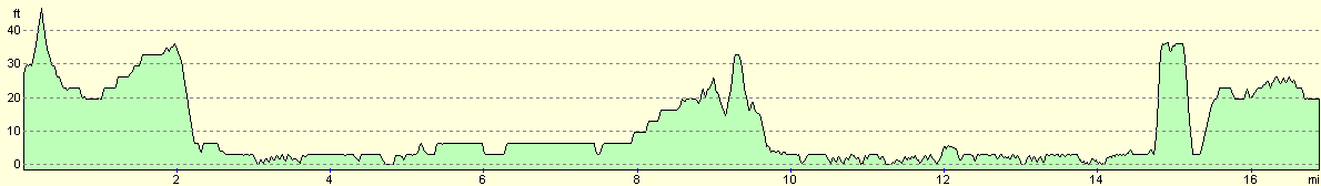
For more information on profiles, ascents and descents, see this page
Accommodation
We were finding it hard to find accommodation in East London, so we drived on a short distance from Wennington to Rainham, where we parked Mervan on a quiet road near a pub.
Disclaimer
Please note that I take no responsibility for anything that may happen when following these directions. If you intend to follow this route, then please use the relevant maps and check the route out before you go out. As always when walking, use common sense and you should be fine.
If you find any information on any of these routes that is inaccurate, or you wish to add anything, then please email me.
All images on this site are © of the author. Any reproduction, retransmissions, or republication of all or part of any document found on this site is expressly prohibited, unless the author has explicitly granted its prior written consent to so reproduce, retransmit, or republish the material. All other rights reserved.
Although this site includes links providing convenient direct access to other Internet sites, I do not endorse, approve, certify or make warranties or representations as to the accuracy of the information on these sites.
And finally, enjoy your walking!
This walk was mentioned in the following routes:
| My walk around the coastline of Britain |
Nearby walks
| # | Title | Walk length (miles) |
|---|---|---|
| 123 | Mile End to Dartford | 15.0 |
| 161 | Gravesend to Dartford | 7.2 |
| 176 | Gravesend to Rochester | 17.2 |
|
|

|