Walk #280: Chalkwell to Stanford-le-Hope
 |
 |
|
General Data
| Date Walked | 28/11/2002 |
| County | Essex |
| Start Location | Chalkwell |
| End Location | Stanford-le-Hope |
| Start time | 08.32 |
| End time | 15.26 |
| Distance | 16.8 miles |
| Description | This was a long walk along footpaths and road, slowly following the northern bank of the Thames westwards towards the centre of London. |
| Pack | Today I carried my 30-litre Karrimor HotRock rucksack, which was filled with my packed lunch, waterproof leggings, water bottle and a couple of spare shirts, together with the usual assortment of odds and ends. |
| Condition | I feel absolutely fine after this walk, and have no significant problems to report. |
| Weather | The day started off quite sunny, but later on it started to cloud over more, and late on it started to rain. The rain was in showers, some of which were heavy, and the wind made it quite unpleasant at time. The majority of the day was dry and sunny, however, so all in all I have had worse days. |
| OS map | Landranger number 178 (Thames Estuary, Rochester & Southend-on-Sea) |
 |
 |
|
 |
 |
|
Map of the walk
Maps courtesy of Google Maps. Route for indicative purposes only, and may have been plotted after the walk. Please let me have comments on what you think of this new format. For a detailed table of timings for this walk, please see the table file.
Notes
This was a landmark day, as I finally passed the 1,000 mile mark of my walk. This has taken me 59 days, which makes an average of almost exactly seventeen miles a day. I find this figure to be almost overwhelming - it is much more than the shortest Land's End to John O'Groats and I have done it in a much shorter time than I had been expecting. I find it quite overwhelming to think exactly how far I have come and how far I have still to go - it is probably best not to think about the latter figure, as it is just too vast a distance to contemplate.
My next target is to complete 20% of the walk, which should be at 1,100 miles in less than a week's time, and this should be just the other side of London. We will not celebrate that target, but it is an important psychological target for me to reach, as will 25%, or a quarter of the walk.
To celebrate the achievement Sam cooked me a lovely dinner of trout with potatoes, and we cracked open a bottle of champagne to make the evening go with even more of a bang. This meant that I woke up the next morning with a little bit of a champagne hangover, but that is never as bad as a beer hangover, and it soon disappeared.
There was still some food left over from last night, and so Sam offered to meet me at lunchtime so that she could reheat the leftovers and I could have it for lunch. After looking at the map we agreed to meet at Pitsea Station, where I had two large helpings of spaghetti bolognaise which meant that for the next hour of the walk I was wobbling slightly. Her cooking is absolutely superb, although perhaps eating two helpings at lunchtime was not the most sensible thing I could have done.
It was whilst I was eating my lunch that I noticed that I would have to change my route. I had intended to head south from Stanford-le-Hope along footpaths, but I noticed that there was gap in the footpath coverage around Mucking Flats, so I decided to make it a road walk around the local villages. Unfortunately after I reached Corringham it started to rain, with one long heavy shower, and so I decided to cut the walk short and instead of walking to Coalhouse Fort to the southeast of East Tilbury, I decided to stop a the campsite. This was probably a good decision, as after I stopped there was another heavy shower, and it will allow me to have an early start tomorrow without Sam having to drive me anywhere.
The last part of the journey along the road from Mucking was absolutely horrid. The rain was streaming down and the road was thick with wet mud. This would have been okay if it had not been for a stream of large lorries which kept on passing me, each one having a haze of brown mist behind it. Unfortunately this mist seemed to be almost magnetically attracted to me, and after each one passed I was covered in a thick gloop, which in one case was so thick that I could not read the map properly without wiping it with my sleeve. To make matters worse, the road was quite twisting and I had to walk very carefully to ensure that any of these lorries, which were essentially going down a country lane, did not hit me. This made the walk understandable unpleasent, and I was glad when that stretch of road finally ended.
We had a phone call tonight from a lady who we had met at the campsite in Edinburgh. She called to tell us that her dog, who had been at the site and Sam had befriended, had died. She had looked at our website and was wondering how I was doing, so Sam told her the details. It feels really strange to be in contact with someone who is associated in my mind with the start of the walk in Edinburgh, the start of the walk, and it is a massive coincidence that she should get in contact with us on the day I completed 1,000 miles.
Directions
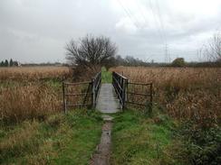
This walk starts off at Chalkwell, just to the west of the station. Walk westwards along the road until a park is reached on the left. Head through the park and then cross the railway line by means of a pedestrian footbridge. On the other side of the bridge descend down onto the path which runs beside the railway line and then turn right to head westwards alongside the railway line. The path passes a yacht club before ending at a road in Leigh-on-Sea. Continue straight on down this road and follow it around beside the railway line until it passes Leigh-on-Sea station.
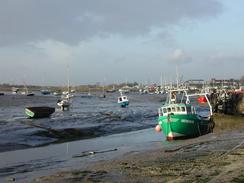
Join the road that passes the station and then turn right down a footpath that follows the top of a bank that heads in a roughly westwards direction. The path crosses over the road that leads to Two Tree Island and continues on the other side, passing across Hadleigh Marsh. After a few miles the path reaches Benfleet Creek, where many boats are moored, and passes the large tidal barrier before ending at a bend in the main road.
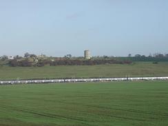
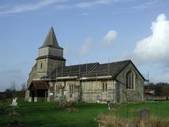
Join the main road and follow it for a short distance northwestwards to Benfleet Station. At the station join a path that runs along the top of the bank once more as it heads in a rough westerly direction once more for about a mile to the A130 road. The path passes under the A130 road and then leaves the bank to cross the Bowers Marshes. The path across the marshes is waymarked but it is very twisting, and I got myself lost and had to make my own way across the marshes. The path eventually makes its way northwards to the railway line, which is crossed by a bridge before turning to the left. The path descends from the bridge to follow the railway line westwards, passing a church before continuing on to meet a road beside Pitsea Station.
Turn right down this road and follow it as it heads under the A13 and meets the B1464 road. Turn left down the B1464 and follow it as it passes through Vange for a couple of miles until it ends at a roundabout above the A13. At the roundabout turn left across the A13 to another roundabout, and head straight on down another road for a couple of miles until it nears the church in Fobbing. In Fobbing turn right down another road, and then take a footpath that leads off to the left. This path heads westwards until it emerges beside Corringham Church.
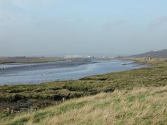
Go through the church graveyard and on the other side take a path that leads to the dual carriageway A4014 road. Cross the road and follow the path on the other side as it heads towards the farm at Old Hall. The path then turns to the right until it nearly reaches the A4014 road once more. It then turns to the left to head southwestwards for a short distance until it meets a surfaced road. Follow this road as it heads southwestwards once more, passing Oak Farm. When the road turns sharply to the right turn to the left down a track for a few yards before turning to the right down another footpath, which roughly follows the line of some overhead power lines until it ends at a road to the southeast of Stanford-le-Hope.
Turn left down this road and follow it as it heads under a railway bridge. On the other side of the bridge climb up the embankment to the right and follow a footpath that leads southeastwards and ends at a road in Mucking. Turn right down this road and immediately pass the church, which is now a private residence, and cross over the railway line using a level crossing before reaching the end of the road. At the end of the road turn left and follow Butts Lane as it twists and turns southwestwards. After about a mile the campsite is reached on the right at Walton Hall Farm, where this walks ends.
Distances
| From | To | Distance (m) | Ascent (ft) | Descent (ft) |
|---|---|---|---|---|
| Chalkwell | Pitsea Station | 8.5 | 259 | 295 |
| Pitsea Station | Campsite in Stanford-le-Hope | 8.3 | 318 | 341 |
This makes a total distance of 16.8 miles, with 577 feet of ascent and 636 feet of descent.
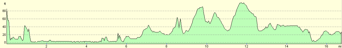
For more information on profiles, ascents and descents, see this page
Accommodation
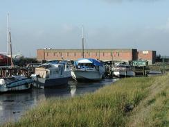
We stayed at Walton Hall Museum, Walton Hall Road, Linford, Stanford-le-Hope, Essex SS17 0RH, telephone 01375 671874. This little campsite was on the site of a farm museum with many interesting exhibits, and although they were full they rolled out an electricity lead for us, which was very kind of them. The site cost us six pounds for the night, although they did not have a shower.
Disclaimer
Please note that I take no responsibility for anything that may happen when following these directions. If you intend to follow this route, then please use the relevant maps and check the route out before you go out. As always when walking, use common sense and you should be fine.
If you find any information on any of these routes that is inaccurate, or you wish to add anything, then please email me.
All images on this site are © of the author. Any reproduction, retransmissions, or republication of all or part of any document found on this site is expressly prohibited, unless the author has explicitly granted its prior written consent to so reproduce, retransmit, or republish the material. All other rights reserved.
Although this site includes links providing convenient direct access to other Internet sites, I do not endorse, approve, certify or make warranties or representations as to the accuracy of the information on these sites.
And finally, enjoy your walking!
This walk was mentioned in the following routes:
| My walk around the coastline of Britain |
Nearby walks
| # | Title | Walk length (miles) |
|---|---|---|
| 161 | Gravesend to Dartford | 7.2 |
| 176 | Gravesend to Rochester | 17.2 |
| 276 | Althorne to Battlesbridge | 17.7 |
|
|

|