Walk #517: Strathcanaird to Altandhu
 |
 |
|
General Data
| Date Walked | 03/08/2003 |
| County | Highlands |
| Start Location | Strathcanaird |
| End Location | Altandhu |
| Start time | 09.45 |
| End time | 17.05 |
| Distance | 14.9 miles |
| Description | This was a walk of two halves; a strenuous and exhilarating walk along a path to Achduart was followed by an enjoyable road walk northwestwards to Altandhu. |
| Pack | Today I carried my 30-litre Karrimor HotRock rucksack, which was filled with my packed lunch, waterproof leggings, water bottle and a couple of spare shirts, together with the usual assortment of odds and ends. |
| Condition | I did not feel as bad as I did yesterday (which was a good thing considering how strenuous the walk was), but my cough was still bad, and I was sick twice early on in the walk. As well as this, my right shoulder ached today, which was annoying. |
| Weather | The main feature of today's walk was the wind, which gusted quite strongly at times during the day. There was also a fair amount of cloud, but this was tempered with some sunshine. Just before lunch there was a light shower, but I missed most of this during lunch. It was not a warm day, which is annoying considering that the weather is supposed to be lovely in the rest of the country. |
| OS map | Landranger number 15 (Loch Assynt, Lochinver & Kylesku) |
 |
 |
|
 |
 |
|
Map of the walk
Maps courtesy of Google Maps. Route for indicative purposes only, and may have been plotted after the walk. Please let me have comments on what you think of this new format. For a detailed table of timings for this walk, please see the table file.
 |
Notes
When I woke up yesterday morning I felt absolutely rotten, as I had been coughing hard all night and had not slept well. I was in two minds about whether to do a walk or take my eleventh day off of the walk, and my mind was made up when I stood up and the world started spinning. The weather outside was cloudy and the wind was gusting, and my mood matched the lousy weather in a very suitable manner. Sam had booked Mervan into a place in Inverness for it's MOT, and so I had to reluctantly get up and dress ready for the long drive. One positive thing about taking a day off was that I could give Sam some company on her drive, and I enjoyed the drive across the country immensely as it passed through areas that I had walked through before, such as Garve.
I really did not want to sit around whilst the MOT was done, so Sam dropped me off in Inverness so that I could do some shopping. I ended up buying myself a small camera tripod and 25 recordable CDROM's, which should last me until the end of the walk. Whilst walking through the city I passed a street vendor who was selling garlic, and the small made me feel nauseous and I started coughing and retching. I managed to run into some public toilets (which coast twenty pence to spend a penny), before I was sick. Unfortunately it looked as though I had taken too much on considering that I was not one hundred percent. Eventually I decided on some retail therapy and went into Waterstone's and bought three books - one of which I had nearly completed this morning. Sam phoned up to tell me that Mervan had passed the MOT except for a tyre that needed replacing and a number plate bulb that was out, so these got fixed and she came to meet me in the city.
Sam did not fancy looking around Inverness and so we drove back to Ullapool, calling in at the Aultguish Inn on the way to have a drink and break the journey. Once we arrived in Ullapool we drove to the supermarket, and we stayed in the car park until about eight. There was no overnight parking in the car park, so we moved onto a nearby street near a school. Up until now the day had been a nice one (despite my being sick), but unfortunately this was to change.
I went to bed early as I was feeling under the weather, and at a few minutes before midnight we were both awoken by a furious hammering on the door and side of Mervan. I was naked, so whilst I struggled under the bed trying to find my clothes Sam went out in her pyjamas. I could hear much shouting outside, and so I ended up putting my coat on over my boxers and stepping out. I was greeted with a short and slightly dishevelled Scotsman yelling at Sam, and Sam trying her best to remain civil. I interjected, and as the man spoke at me I was greeted with a face full of spit and drivel, and the smell of stale alcohol almost overwhelmed me. He wanted us to move the van immediately because it was in front of his house and if we did not do so 'we would know about it' (quite what he was threatening us with he did not reveal). I tried to explain that according to the law we could park on the roadside legally and we apologised for any inconvenience that may have resulted, but he just threatened us again (I found this funny as he was a good six inches shorter than me and had to shout up at me). I was loathe to move at that time of night, and so I tried to explain that I was doing a walk for charity, but he brushed it aside with the comment 'We don't believe in charity - charity begins at home'. In which case, I thought, I hope that none of your family ever become ill, as you would not want to have the help of any of the thousand of charities out there that help people. A nasty thought, I have to admit, but one that I could not help having.
It was more than obvious that we would have to move, so Sam went in and started getting Mervan ready whilst I tried one last attempt to reason with the rather drunken man. This was almost bound to fail, and so I jumped into Mervan and we drove off, leaving the man waving his hands above his head in celebration. Ullapool had more than lost its attractions after this little event, and so we decided to drive on to the little car park where we had spent the previous night which would mean that I could start the walk earlier in the morning. It is a shame, but events like this put a stain on a place in our minds, particularly when we have never been there before, and Ullapool will remind me of this man for some time.
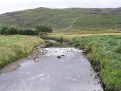
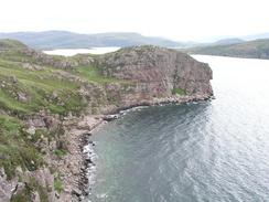
Because of these events when I woke up this morning I was exceedingly tired. I was also, however, feeling slightly better, and although I was still coughing I resolved to do a walk today. I had a few coffees to wake me up, and then set out on the walk. The first part of the walk was a short stroll along a road to Blughasary and the River Runie, where I joined a path that headed westwards. The path over this stretch was very distinct, and although rough in places as easy going. Before the path reached the fort near Dun Canna it divert steeply uphill, and this started one of the most exhilarating stretches of path that I have done for some time. The initial stretch went steeply uphill, and the exertion caused me to have a coughing fit that made me retch and eventually be sick. This happened once more before the terrain levelled off and I was left with a superb walk along a fairly distinct path through rocky valleys - an excellent walk, and one that I would love to do it again sometime.
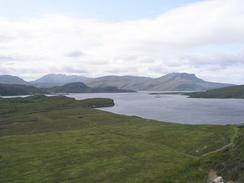
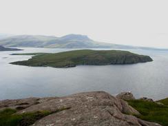
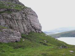
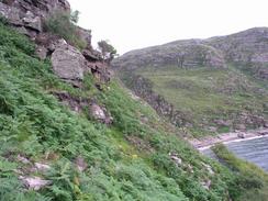
The going remained good until just before I had to descend down into the valley of the Garbh Allt, which was a steep descent along a steep-sided cliff. On the other side of the stream I was faced wit a very steep climb, and due to the vegetation having burned off I could not see the path, although I had seen it higher up on the descent. I made my way uphill, and eventually found the path. It was a very hard walk, and over the course of an hour I walked a mile, which shows exactly how strenuous the terrain was. I was glad when the terrain levelled off and I could follow a good path past Culnacraig and on towards the road at Achduart. As I was walking along the path I found that I could get Radio 5 for the first time in two weeks, and so with great joy I could listen to the end of the Formula One race from Germany.
I met Sam for a late lunch in Badenscallie, and she kindly made me a bowl of soup. I had been walking for a relatively long time and had covered nine miles, which shows exactly how hard the walk was. The rest of the day's walk was a simple stroll northwestwards along roads to the little hamlet of Altandhu, where I finished about fifty yards up the road from the pub. I was extremely tempted to walk on further, but I was fairly tied after the exertions of this morning and I was aware that I was not well, and so I decided to stop the walk in the village. We went into the pub for a short while in the evening for a quick drink, although as I was feeling rotten I only had an orange and lemonade.
Directions
This walk starts off at a car park immediately south of the bridge that carries the A835 road over the River Canaird in Strathcaanaird. Leave the car park and turn right to cross the bridge over the river, and on the other side turn left down a road that parallels the river westwards until it ends at Blughasary. When the road ends continue straight on down a rack until a bridge over the River Runie is reached. Do not cross the bridge that takes the bridge that carries the track over the river, but take a footbridge that is a few yards away to the left.
The footbridge leads to a footpath that leads westwards across some rocky moorland. The path is very distinct but a bit rough, and eventually it meets the river once more. About fifty yards before the path meets a gate in a fence another, rougher, path heads uphill to the right. This path is marked by occasional cairns and wooden posts, but in places these are not frequent, and this is the case on this first ascent. Eventually the path flattened out and what follows is a beautiful walk westwards through rocky valleys, along a path that is extremely rough in places. The path starts getting rougher again as it skirts along a rough cliff past Geodha Mor and descends down into the valley of the stream of the Garbh Allt.
From here the path heads steeply uphill up the northern side of the valley, before skirting the cliffs below Garbh Choireachan westwards. It is quite indistinct on the ground and the path is extremely rough; care must be taken as one slip could easily be fatal. It is a hard walk but strangely rewarding, and I was disappointed when the gradient slackened and the path became far easier. It crosses the Allt nan Coische and heads towards the buildings at Culancraig, but do not head uphill towards the buildings but take a distinct path that heads westwards across the moorland for a little over a mile until it joins a track and then a road at Achduart.
Join the road and follow it as it heads northwards through Achnacarinan until it ends at a T-junction. Turn left at the junction and follow the road northwestwards through Achvraie and past the car park of a youth hostel, after which is heads through a long string of houses stung out along the road, through places such as Polglass and Achilitibuie. The road passes a war memorial, and by some public toilets turn left down another road. Follow this road as it passes a little beach and then climbs up through Polbain and on past two lochs and into Altandhu. This walk ends about fifty yards up the road from the pub in the village.
Distances
| From | To | Distance (m) | Ascent (ft) | Descent (ft) |
|---|---|---|---|---|
| Strathcanaird | Achduart | 7.2 | 1647 | 1578 |
| Achduart | Altandhu | 7.7 | 748 | 778 |
This makes a total distance of 14.9 miles, with 2395 feet of ascent and 2356 feet of descent.
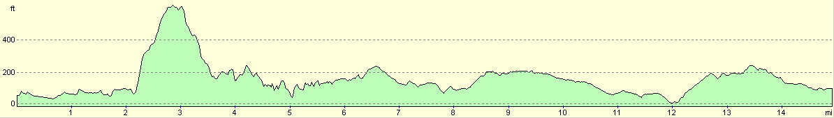
For more information on profiles, ascents and descents, see this page
Accommodation
We parked Mervan in a roadside lay-by a hundred yards or so down the road from the pub in Altandu. We were hesitant about parking on the roadside after last night's events, and we could only hope that we would be okay as the pub car park was a little too small for us to park in.
Disclaimer
Please note that I take no responsibility for anything that may happen when following these directions. If you intend to follow this route, then please use the relevant maps and check the route out before you go out. As always when walking, use common sense and you should be fine.
If you find any information on any of these routes that is inaccurate, or you wish to add anything, then please email me.
All images on this site are © of the author. Any reproduction, retransmissions, or republication of all or part of any document found on this site is expressly prohibited, unless the author has explicitly granted its prior written consent to so reproduce, retransmit, or republish the material. All other rights reserved.
Although this site includes links providing convenient direct access to other Internet sites, I do not endorse, approve, certify or make warranties or representations as to the accuracy of the information on these sites.
And finally, enjoy your walking!
This walk was mentioned in the following routes:
| My walk around the coastline of Britain |
Nearby walks
| # | Title | Walk length (miles) |
|---|---|---|
| 515 | Little Gruinard to Blarnalearoch | 20.3 |
| 516 | Blarnalearoch to Strathcanaird | 19.0 |
|
|

|