Walk #515: Little Gruinard to Blarnalearoch
 |
 |
|
General Data
| Date Walked | 31/07/2003 |
| County | Highlands |
| Start Location | Little Gruinard |
| End Location | Blarnalearoch |
| Start time | 09.02 |
| End time | 17.18 |
| Distance | 20.3 miles |
| Description | This was a nice walk, along both road and tracks, taking me from Little Loch Broom to Loch Broom itself. |
| Pack | Today I carried my 30-litre Karrimor HotRock rucksack, which was filled with my packed lunch, waterproof leggings, water bottle and a couple of spare shirts, together with the usual assortment of odds and ends. |
| Condition | I feel absolutely fine after this walk, and have no significant problems to report. My shoulder and neck were fine for the first time for a while, and my feet gave me no trouble either. I could easily have walked further, but there was no real need and would lead me to doing a shorter day tomorrow. Unfortunately there is one non-walk related problem to report; I have a nasty cough that seems to have got worse over the last couple of days, but it has not got bad enough yet to interfere with the walk. |
| Weather | Today was a generally cloudy day with only occasional sunshine. There was also some drizzly rain, although this we never heavy or sustained for any significant period. It was quite a warm day, although it was quite windy when I was in exposed places. |
| OS map | Landranger number 19 (Gairloch & Ullapool, Loch Maree) and Landranger number 20 (Beinn Dearg & Loch Broom, Ben Wyvis) |
 |
 |
|
 |
 |
|
Map of the walk
Maps courtesy of Google Maps. Route for indicative purposes only, and may have been plotted after the walk. Please let me have comments on what you think of this new format. For a detailed table of timings for this walk, please see the table file.
Notes
I woke up this morning undecided about what my plns for the day were. It had rained overnight, and it was raining sporadically first thing in the morning whe I woke up. I was in two minds about what to do during the day, and I eventually decided that I would delay the decision until lunchtime, a classic example of my prevarication. I have had trouble with one of my walking poles recently as I could not tighten up the lower section of one of them. I knew that there was a possibility that I may have to go over rough ground today, and so I took the pole apart to see what was wrong. I have had both poles for years and they have given sterling service, but I was afraid that it had finally given up the ghost. Fortunately when I had taken it to pieces I found that the screw thread was all gunked up, and once I had degunked it I could tighten it up easily and securely. This small thing put me in a good mood, as the poles have been with me since before the Pennine Way, and they seem as much a part of my walking as any other part of my kit.
Because I was unsure of what I was doing I decided that an early start would be necessary, as this would give me flexibility to make a decision to extend the walk later if I wanted. The initial part of the walk was a long and fairly uninteresting plod along the A832 road, which was only enlivened by occasional glimpses over to Gruinard Island. Things became better when the road climbed up eastwards towards the top of Druim nam Fuath at nearly 180 metres. At the top of this there was a car park from where there were some superb views up and down Little Loch Broom, and I stopped for a few minutes to admire the view. It was here that I made the decision not to walk around the peninsular to Cailleach Head; there is a rough path long the southern side of this peninsular from the end of the road at Badrallach, but no path on the northern side. I could see fairly magnificent hills, including the beautiful 635-metre Beinn Ghobhlach, and I could imagine that any route along the northern side of these mountains would be strenuous and not worth the bother.
Sam had been into a hostel in Camusnagaul to use the Internet, and we have had some nice emails about the walk and website, which I shall have to reply to when I get to Ullapool. I met Sam at the Dundonnell Hotel, which we retired to so that I could have a drink and use the facilities - the pint of John Smiths was far from nice, and I am looking forward to being able to get a decent pint sometime. After we got back to the van I had to commit myself to where I was going to complete the day's walk, and as I was feeling fit I decided to end at the road opposite Ullapool beside Loch broom. This involved doing a couple of miles along pathless terrain at the end of the day, but this was just more of a challenge.
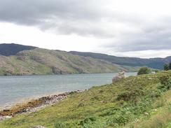
A nice if rocky suspension bridge took me over the Dundonnell River and towards a public road through an estate. A stiff climb north uphill followed this with some superb views back over Little Loch Broom and An Teallach. Eventually I started the descent down to the Altnaharrie Hotel along a rough track, but just before I reached this I diverted east along another track that soon ended. What followed was a nice if strenuous walk along the side of the loch, sometimes on the foreshore and at others climbing up other small cliffs. Despite the strenuous nature of the walk I very much enjoyed it, and in a strange way I was sad when I eventually dropped down to the foreshore of Camas A' Chonnaidh for the last time to make my way to some shielings, where a path took me onwards to the road and the end of the walk.
Tomorrow I have a long road walk to do around Loch Broom and through Ullapool; as this is the last town of any size that we shall pass through until Thurso or Wick I intend to spend some time in the town getting things ready for the next few weeks. Cape Wrath and the end of the east coast is getting closer, and I can hardly wait to get there and start the north coast, although the scenery over the next few days should be fantastic.
I have been sent a link for more information on the camusnagaul and Dundonnell areas.
Directions
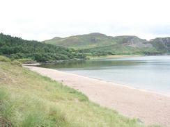
This walk starts off at a car park by Little Gruinard Beach beside the A832 road. Leave the car park and turn right to follow the A832 northeastwards as it crosses the Gruinard River, where it heads northwards for a mile past Gruinard House. The road then turns to the right to head eastwards uphill beside the Allt Mhungasdail towards the summit of Druim nam Fuath, where there is a car park with some terrific views. The road then slowly descends past Badcaul, where it joins the southern bank of Little Loch Broom that it follow eastwards through Camusnagaul to the end of the loch at Dundonnell.
Pass the Dundonnell Hotel and a little car park, before taking a track that leads off to the left towards a farm. The track passes through the middle of the farm before turning to the right to head in an easterly direction for about half a mile, after which it turns to the left and reaches a suspension bridge. Cross the bridge and on the northern side join a track that heads southeastwards past Eilean Darach before ending at a public road. Turn to the left and follow this road as it heads eastwards for a couple of hundred metres before turning to the left to climb uphill northwards through woodland.
Eventually the road breaks out of the woodland and heads northwards past a high hill to the right until it reaches a summit at nearly 236 metres high. At a hairpin bend continue straight on down a track that heads northeastwards downhill past Loch na h-Airbhe towards the Altnaharrie Hotel. When the path to the ferry leads off to the left continue straight on down the track that heads eastwards for another couple of hundred yards. When the track ends continue straight on along a very indistinct path, and from here just follow the coast around. The hardest section is where there is a small patch of woodland; I had to climb up through this to avoid a cliff that I could not skirt below. Eventually the little bay of Camas A' Chonnaidh is reached, and as the tide was low I could follow the foreshore around this bay until a white cottage is reached. At the cottage turn right to head inland to some ruined barns, and then turn left along a track that heads southeastwards uphill to the end of the road in Blarnalearoch. This walk ends a couple of hundred yards down the road in a lay-by.
Distances
| From | To | Distance (m) | Ascent (ft) | Descent (ft) |
|---|---|---|---|---|
| Little Gruinard | Dundonnell | 11.7 | 1532 | 1496 |
| Dundonnell | Blarnalearoch | 8.6 | 1385 | 1243 |
This makes a total distance of 20.3 miles, with 2917 feet of ascent and 2739 feet of descent.
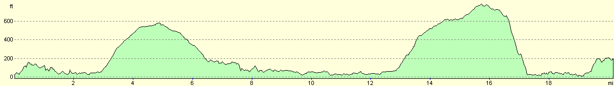
For more information on profiles, ascents and descents, see this page
Accommodation
We parked for the night in a lay-by a few hundred yards south of the end of the road in Blarnalearoch. There were no facilities nearby and the midges were biting, but we have certainly parked in worse places.
Disclaimer
Please note that I take no responsibility for anything that may happen when following these directions. If you intend to follow this route, then please use the relevant maps and check the route out before you go out. As always when walking, use common sense and you should be fine.
If you find any information on any of these routes that is inaccurate, or you wish to add anything, then please email me.
All images on this site are © of the author. Any reproduction, retransmissions, or republication of all or part of any document found on this site is expressly prohibited, unless the author has explicitly granted its prior written consent to so reproduce, retransmit, or republish the material. All other rights reserved.
Although this site includes links providing convenient direct access to other Internet sites, I do not endorse, approve, certify or make warranties or representations as to the accuracy of the information on these sites.
And finally, enjoy your walking!
This walk was mentioned in the following routes:
| My walk around the coastline of Britain |
Nearby walks
| # | Title | Walk length (miles) |
|---|---|---|
| 514 | Poolewe to Little Gruinard | 19.8 |
| 516 | Blarnalearoch to Strathcanaird | 19.0 |
|
|

|