Walk #279: Little Wakering to Chalkwell via Southend-on-Sea
 |
 |
|
General Data
| Date Walked | 27/11/2002 |
| County | Essex |
| Start Location | Little Wakering |
| End Location | Chalkwell |
| Start time | 07.50 |
| End time | 15.02 |
| Distance | 18.9 miles |
| Description | This was a nice walk along riverbanks and roads into and then slightly out of Southend-on-Sea. The highlight of the day had to be Southend pier, which I just had to walk down. |
| Pack | Today I carried my 30-litre Karrimor HotRock rucksack, which was filled with my packed lunch, waterproof leggings, water bottle and a couple of spare shirts, together with the usual assortment of odds and ends. |
| Condition | I feel absolutely fine, although slightly fatigued, after this walk. I have had no problems of any significance, and I could have walked further after a little rest if I had needed to. |
| Weather | The weather today was lovely, with sunshine for most of the day with some cloudy periods. There was no sign of any rain, although there was gusting, strong wind in exposed places. All in all it was another lovely day. |
| OS map | Landranger number 178 (Thames Estuary, Rochester & Southend-on-Sea) |
 |
 |
|
 |
 |
|
Map of the walk
Maps courtesy of Google Maps. Route for indicative purposes only, and may have been plotted after the walk. Please let me have comments on what you think of this new format. For a detailed table of timings for this walk, please see the table file.
Notes
The first part of today was yet another boring walk along river banks, with very little of any interest to be seen. I simply put my Walkman onto Radio Five and walked on, ignoring what I could hear, see or, in the area opposite the tip on Barling Marsh, smell. Doing this makes the time pass more quickly than a more interesting walk where I savour every moment, but even so that part of the walk did not go fast enough, and I was very thankful when the route along the riverbanks ended for the day and I had joined the road.
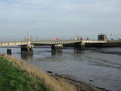
I had planned to walk as far as possible along the public footpath which follows the seawall towards the Ministry of Defence Shoeburyness firing range, but when I reached the bridge over to Foulness Island I found the gate well and truly locked. The grass on the other side of the gate was well trodden, so I can only assume that they lock the gates whenever firing is occurring and that it is open at all other times. This is fair enough, but I was annoyed that I had to walk half a mile back to Oxenham Farm to avoid the ranges; it would be much better if there could be a sign at the farm saying whether or not the footpath is closed further on. The sound of the firing was quite impressive at times, and as I walked alongside the access road later on I saw an artillery piece being towed away by an army tractor. It led me to wonder exactly what happens on the range - I am sure that I would find it very interesting to see what happens over there and how everything works. The range was established in 1858 to test Armstrong guns against Ironclad warships, which must have been a sight on its day.
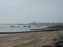
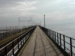
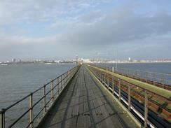
The highlight of today has to be Southend Pier, which is the longest pleasure pier in the world. It looked fairly impressive as I walked up to it, and as I had shortened my walk slightly around the firing ranges I decided to go for a walk along the pier. This was a pleasant walk in the afternoon sun, and as I walked the railway line which runs from the shore to the pier head passed me several times. As I walked my mind flashed back to the starting scenes of the later series of the 'Minder' TV program, where the two main characters are walking along the pier, and I could not help but starts singing the theme tune, 'I Could be so good for you', which seems to amuse some people passing by. The pier (which replaced an earlier one) was opened in 1889 and was extended slightly in 1897 with the addition of the New Pier Head. The railway line was originally an electric tramway, and one of the green 'Toast Rack' cars is at the entrance to the pier. It opened in 1890 and carried 65 million passengers until they were replaced with modern trains in 1949. The pier has had a turbulent history, and in 1976 a massive fire that gutted the entire two-storey structure devastated the New Pier Head. Fortunately the cast iron piles survived undamaged, and this allowed the deck to be reconstructed in 1989, the hundredth anniversary of the pier. In 1986 the Coaster 'Kingsabbey' hit the pier and destroyed the Pier Head lifeboat house, and this was replaced with the modern structure in 1991. At the Pier Head it was nice to see a large amount of work going on to create a new boathouse and crew facilities for the RNLI station and to reopen the sundeck to the public. I was very interested to see the work in progress, and the way the massive baulks of timber sat upon the cast iron supports.
By the time it got towards eleven I was desperately in need of going to the toilet. I decided the best way of doing this was to go into the Shoeburyness Hotel when I passed it, and I had a pint of John Smiths on order to be able to use their facilities. On the way to the toilet I passed a poster advertising three local men who did a 30-day, 2,000 mile bike ride around Britain to raise money for a local charity, and I copied details down so that I could get in contact with them about what they did.
Tomorrow I will have reached the 1,000 mile of my walk, which I feel is a major achievement in anyone's book. I find it extremely strange that I have been going for two months, but Spud Talbot-Ponsonby did a 4,500 mile walk, and so I have the same distance still to do that she did in the entirety of her walk. This 1,000 mile difference is all accounted for in the estuaries I have to walk up, and I have found out in the last few weeks exactly how long and time-consuming these diversions are.
Directions
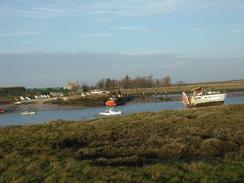
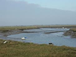
This walk starts off at the church in Little Wakering. From the church head north up the road for a little under a kilometre, following is as it curves to the left and then the right. Just after the village sign turn right down a surfaced footpath that leads to the end of a creek. At the creek take the right-hand fork to skirt the southern edge of the creek. The path continues beside the creek as it heads eastwards before turning northeastwards to Fleet Head and then going in a large loop northwards, squeezed between Barling Marsh and Potton Island, before reaching the bridge that leads to Potton Island.
Continue on beside the creek as it heads southwards, passing a little boatyard before turning around a small creek to head around to Oxenhame Farm. If there is not artillery firing going on the path through the range may be open; if not then climb down the bank and enter the farm. Walk through the farm and then take a footpath that follows a track southwards for about half a mile before ending at a road in Samuel's corner. Follow the road around a left-hand bend and at the start of the right-hand bend continue straight on down a footpath that leads southwestwards beside the fence into the MOD ranges. When the path ends at a road turn right down this road to head westwards along a road, which does not have a pavement. Take the first road to the left, Wakering Road, and follow it as it heads into Shoeburyness.
At Shoeburyness Station continue on until just before the Shoeburyness Hotel is reached, and then turn right down a road that continues westwards for a kilometre until it ends at the B1016 road. Turn left down the B1016 road and follow it southwards until it meets the sea by the coastguard station. At the seafront turn right and follow the promenade beside the beach (or walk along the beach) westwards for three miles to Southend Pier. If you want you can then walk along the pier; it would be a shame not to do this as it is a nice walk in good weather. From the pier entrance continue on westwards along the promenade through Westcliff-on-Sea beside the Western Esplanade, until the Crow Stone is reached. Here I turned right to head inland along Chalkwell Avenue, passing under the railway line before turning left along Grand Parade, which slowly rose up past Chalkwell Station and continued on for another few hundred yards, where Sam picked me up.
Distances
| From | To | Distance (m) | Ascent (ft) | Descent (ft) |
|---|---|---|---|---|
| Little Wakering | Samuel's Corner | 7.6 | 85 | 98 |
| Samuel's Corner | Southend-on-Sea pier head | 7.6 | 66 | 72 |
| Southend-on-Sea pier head | Chalkwell | 3.7 | 157 | 72 |
This makes a total distance of 18.9 miles, with 308 feet of ascent and 242 feet of descent.
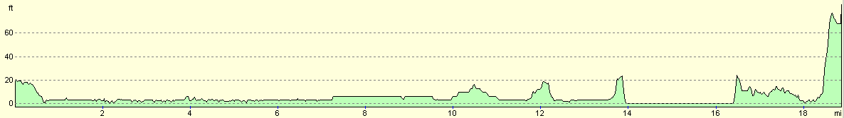
For more information on profiles, ascents and descents, see this page
Accommodation
We stayed at Braehead, 87 Rayleigh Avenue, Leigh-on-Sea, SS9 5DL, telephone 01702 524411. This was a very nice site, with clean toilet and powerful shower, which we had to feed ten pence pieces into. The site cost us five pounds for the night, which was good value.
Disclaimer
Please note that I take no responsibility for anything that may happen when following these directions. If you intend to follow this route, then please use the relevant maps and check the route out before you go out. As always when walking, use common sense and you should be fine.
If you find any information on any of these routes that is inaccurate, or you wish to add anything, then please email me.
All images on this site are © of the author. Any reproduction, retransmissions, or republication of all or part of any document found on this site is expressly prohibited, unless the author has explicitly granted its prior written consent to so reproduce, retransmit, or republish the material. All other rights reserved.
Although this site includes links providing convenient direct access to other Internet sites, I do not endorse, approve, certify or make warranties or representations as to the accuracy of the information on these sites.
And finally, enjoy your walking!
This walk was mentioned in the following routes:
| My walk around the coastline of Britain |
Nearby walks
| # | Title | Walk length (miles) |
|---|---|---|
| 275 | Tillingham Marshes to Althorne Station | 16.0 |
| 276 | Althorne to Battlesbridge | 17.7 |
| 277 | Battlebridge to Wallasea | 15.4 |
|
|

|