Walk #278: Wallasea to Little Wakering
 |
 |
|
General Data
| Date Walked | 26/11/2002 |
| County | Essex |
| Start Location | Wallasea |
| End Location | Little Wakering |
| Start time | 08.14 |
| End time | 14.50 |
| Distance | 18.4 miles |
| Description | This was another day of walking along riverbanks, and another day when I did not end very far from where I started despite a fairly long walk. The main reason for this was the fact that I had to walk up and down the River Roach as far as Rochford in order to cross it. |
| Pack | Today I carried my 30-litre Karrimor HotRock rucksack, which was filled with my packed lunch, waterproof leggings, water bottle and a couple of spare shirts, together with the usual assortment of odds and ends. |
| Condition | I feel absolutely fine after this walk, and have no problems to report. My ankle ached again slightly for a period, but nothing I was worried about as it soon stopped. With a short rest I could easily have walked further, but this endpoint was a very convenient place to stop. |
| Weather | The day started off fairly foggy, but this all vanished within an hour of the start of the walk. The fog was replaced with a mostly sunny day with only a few clouds, It was another fairly warm day for the tie of year, and I can only hope that this sort of weather will continue for as long as possible. |
| OS map | Landranger number 178 (Thames Estuary, Rochester & Southend-on-Sea) |
 |
 |
|
 |
 |
|
Map of the walk
Maps courtesy of Google Maps. Route for indicative purposes only, and may have been plotted after the walk. Please let me have comments on what you think of this new format. For a detailed table of timings for this walk, please see the table file.
Notes
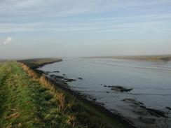
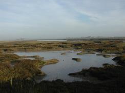
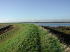
The day started off foggy, so I set off on the walk expecting not to be able to take many good photographs during this walk. Fortunately the fog soon cleared and was replaced with nice sunshine, so I ended up taking lots of photographs of the various creeks and rivers that I walked along, all of which looked glorious in the sunshine.
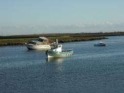
Whilst I was walking along the riverbank near Paglesham Eastend I saw two dogs come running towards me from a boat near the little boatyard there. I am well used to dogs running towards me, so I kept on walking. As they got closer I noticed that they were both border collies, which I normally equate with being friendly dogs. These were far from being friendly, however, as when they reached me one of them went behind me and the other in front of me and they both started growling fiercely. I kept on walking as I was definitely on a right of way, but the dog behind me gave me a nip on my right calf through my waterproofs, trousers, and base layer. I kept on walking, and the other dog joined the dog behind me, and as I walked past a boathouse they stopped there, which I assumed must have been their home. I was absolutely furious about this, and although the dog did not draw blood it was a powerful little nip. Dogs that do that should not be allowed to run loose over public rights of way.
I ate the sandwiches which Sam had made me within a couple of hours this morning, and by lunchtime I was getting quite hungry once more. Whilst walking through the industrial estate near Sutton Bridge I came across a sandwich van parked on the roadside. Immediately my stomach took advantage in a temporary lack of willpower and I found myself stopping to order a bacon and egg baguette. By the time the order came by some amazing process it had transmogrified into a burger, onion, bacon and egg baguette. Since this only cost me two pounds and seventy pence I did not feel like complaining too much, and I ravenously devoured it as I walked along the road.
One of the things that amazed me today was how quickly the tide came up the river - I was only away from the river for a relatively short period and in that time the mudflats which had been exposed were all covered in water. Before the tide came in it could have been possible to walk across the river it seemed so small (provided you would not have minded getting stuck in the mud), but after the tide came in it seemed a totally different sort of river.
The walk ended at the 11th century Church of St Mary the Virgin in Little Wakering, which is a lovely little church. It has a Rood Staircase (although the rood loft is not present) and an ancient whipping post. Unfortunately I could not go in to see these as the door was locked, something that is probably necessary but annoys me every time that I see it.
Tomorrow will be my last day of walking around innumerable creeks as I reach the mouth of the Thames, where the walk becomes slightly more sane and I can start motoring along the Thames. I must admit that I will not really miss the winding route, and I am very keen to get to London which I have many fond memories of.
Directions
This walk starts off in a lay-by on Creeksea Ferry Road at TQ 92563 94595. A public footpath leads off southeastwards from the lay-by for a short distance to the left of a little creek. After a hundred yards it turns to the right and crosses the creek on a bridge before heading southwestwards across a field. The path closely parallels some overhead power lines for most of the way, and when these turn off to the right continue straight on until the western extremity of Paglesham Creek is reached.
At the creek turn right and climb up onto the top of a bank. Follow this bank as it heads eastwards along the southern edge of Paglesham Creek for a mile before it turns to the right to head southeastwards along Paglesham Pool. After a couple of kilometres the bank meets the River Roach and turns to head southwestwards past a little boatyard until Blackedge Point is reached.
Continue following the north bank of the river as it heads westwards. A diversion has to be made inland near Barton Hall around a little creek before continuing on past Great Stambridge Hall. About a kilometre past here the path along the riverbank is private and the footpath turns to the right to head northwards. When the end of a track is reached turn left along a footpath that heads across a field and crosses a bridge over an old millpond before ending at a road.
Turn left to head southwards down the road for a few yards before turning down a bridleway that leads off to the left. This bridleway curves around a factory before crossing the very end of the River Roach on a bridge. On the other side of the bridge the bridleway turns to the right through an area of scrub woodland. Follow the bridleway for a few yards past the bend and then turn left down a footpath that heads southwards before ending at a road in an industrial estate.
Turn left down the road and then almost immediately turn right down another road. When this road ends at a T-junction turn right and follow this road as it curves around to head southwestwards past some large DIY shops before it ends at a public road by Sutton Bridge. Turn left, cross the bridge and continue on along the road. Take the first road off to the left which heads past Sutton Hall and past the end of some high-tension power lines until it curves to the right. At this bend continue straight on along a surfaced track for about a hundred yards. When the track curves to the left to head northwards past Butlers Farm follow it. It soon becomes unsurfaced as it continues on before turning to the right and heading eastwards for over a mile, passing Mucking Hall before ending at a road.
Turn left up this road and when it curves to the right after a short distance continue straight on up a footpath until it ends at a riverbank on the southern side of the River Roach. Climb up the bank and turn right to follow the footpath which runs along the top as it heads eastwards for a couple of miles until Baring Ness is reached. Here the riverbank turns to the right and joins Potton Creek as it heads southwards, with Barling Marsh to the right. The path curves around and passes a busy (and unfortunately smelly) tip before reaching a few boats moored at Barling. It then heads southeastwards once more along a much rougher section of riverbank. The path curves around to head westwards once more to head into Little Wakering. At the end of the creek continue straight on down a surfaced footpath until it ends at a road at the northern end of the village. Turn left down this road and follow it for a little under a kilometre until Little Wakering church is reached, where this walk ends.
Distances
| From | To | Distance (m) | Ascent (ft) | Descent (ft) |
|---|---|---|---|---|
| Layby next to Wallasea Island | Sutton Bridge | 10.5 | 102 | 105 |
| Sutton Bridge | Little Wakering | 7.9 | 131 | 115 |
This makes a total distance of 18.4 miles, with 233 feet of ascent and 220 feet of descent.
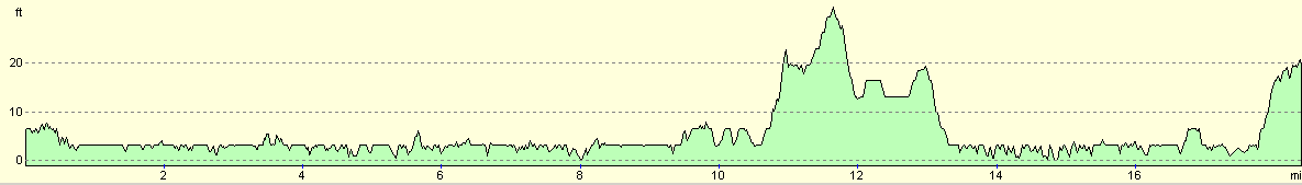
For more information on profiles, ascents and descents, see this page
Accommodation
We had more problems finding a site in the immediate area of the end of the walk, so we asked the landlord of the Castle Inn in Little Wakering if we could stay in the car park. He kindly agreed, and so we spent the night there. In the next couple of nights it may be nice if we found a site so that I could update my website, but it is not vital yet.
Disclaimer
Please note that I take no responsibility for anything that may happen when following these directions. If you intend to follow this route, then please use the relevant maps and check the route out before you go out. As always when walking, use common sense and you should be fine.
If you find any information on any of these routes that is inaccurate, or you wish to add anything, then please email me.
All images on this site are © of the author. Any reproduction, retransmissions, or republication of all or part of any document found on this site is expressly prohibited, unless the author has explicitly granted its prior written consent to so reproduce, retransmit, or republish the material. All other rights reserved.
Although this site includes links providing convenient direct access to other Internet sites, I do not endorse, approve, certify or make warranties or representations as to the accuracy of the information on these sites.
And finally, enjoy your walking!
This walk was mentioned in the following routes:
| My walk around the coastline of Britain |
Nearby walks
| # | Title | Walk length (miles) |
|---|---|---|
| 273 | Maldon to St Lawrence | 16.0 |
| 275 | Tillingham Marshes to Althorne Station | 16.0 |
| 276 | Althorne to Battlesbridge | 17.7 |
|
|

|