Walk #275: Tillingham Marshes to Althorne Station
 |
 |
|
General Data
| Date Walked | 23/11/2002 |
| County | Essex |
| Start Location | Tillingham Marshes |
| End Location | Althorne Station |
| Start time | 08.06 |
| End time | 14.40 |
| Distance | 16.0 miles |
| Description | This was a slightly boring walk along sea banks, passing through Burnham-on-Crouch on the way. |
| Pack | Today I carried my 30-litre Karrimor HotRock rucksack, which was filled with my packed lunch, waterproof leggings, water bottle and a couple of spare shirts, together with the usual assortment of odds and ends. |
| Condition | After this walk I felt fine, with no problems to report aside from a little fatigue. A little while after the walk finished, however, my left ankle started aching and did not stop until I went to bed, which I find slightly worrying. |
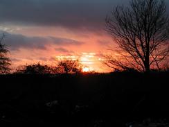
| Weather | Today's weather was mainly cloudy with some stiff breezes. There were a couple of light showers but these were not enough to annoy me. Unlike yesterday there not much of the sun to be seen although it did make occasional appearances. |
| OS map | Landranger number 168 (Colchester, Halstead & Maldon) |
 |
 |
|
 |
 |
|
Map of the walk
Maps courtesy of Google Maps. Route for indicative purposes only, and may have been plotted after the walk. Please let me have comments on what you think of this new format. For a detailed table of timings for this walk, please see the table file.
Notes
As I walked along the track away from the sea wall yesterday afternoon I realised that the van could be driven down the public road as far as Grange Farm, which would save me about a kilometre of walking. This is therefore what we did today - there was plenty of room at the end of the public road in which to turn Mervan before I set off.
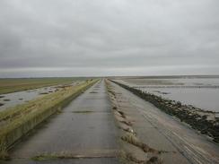
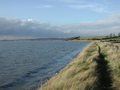
I must admit that I found the first part of this walk as far as Burnham-on-Crouch to be fairly boring. The sea banks seemed to be endless, and although the path was not rough and I could make god time along them I still found this stretch of the walk to be boring, and I had to turn to Radio 5 for some background entertainment as I walked. One of the highlights of this section (if it can be called such) was seeing Foulness Island across the mouth of the River Crouch - the island is a military artillery testing range and I could just make out the high twin tower of an artillery target on the island.
Whilst I was walking along the sea banks near Holiwell Farm I came across a couple of fishermen fishing. As I passed the first of these he caught a fish, which was the first fish that I have seen caught on the entire walk. I chatted to him for a couple of minutes before taking a photograph of him with the fish - a small whiting which he was rather embarrassed about being photographed with. He was a nice fellow, and was exceedingly jolly.
As I was approaching Burnham-on-Crouch I had a phone call from Terry, who was parked at the station in the town. We agreed to meet up at the Ship Inn in the town, and so I went in and ordered a pint of Adnams Broadside whilst I waited. The locals were all very friendly as I chatted to them about what I was doing, and I also spent some time looking at the charts of the local area on the wall. It is strange seeing sea charts - they are a sort of inverse of OS maps. The OS maps show great details on land but not much of the sea, whilst the charts show great detail of he sea but relatively little of the land. I had asked Terry if he could get me OS LandRanger map number 167, which I did not have and I needed for about three or four miles of tomorrows walk to get to the first crossing point of the River Crouch. When he came he bought the map with him, and so I sat down and started doing some preliminary planning for tomorrows walk. Whilst I did this I also had another pint, which with hindsight was a mistake as it made the last few miles of the day much harder than they should have been.
Creeksea is reputed to be the place where King Canute attempted to hold back the tide (this is also claimed by Bosham in Sussex). The river is fairly wide at this point, and as I stood near the sailing club I found myself wishing that I could old back he tide and walk across the river - it would certainly have saved many miles of walking over the next two days.
I am now starting to find all these long estuaries to be very boring and quite bad for my spirit - it is not the fault of the estuary as I have found other estuaries to be quite interesting, but it is the fault of the miles of sea banks with very little of any interest to be seen. I find this to be quite soul destroying, and it is with relief that I realise that today was probably the last day of this sort of walking for some time, as I am now approaching areas with lots of towns and villages as I start my final approach to London.
Directions
This walk starts off at the end of the public road at Grange Farm (grid reference TM 01296 02294). From the end of the public road continue straight on down a track that turns to the left to lead to Howe Farm. Follow the track past the farm as it turns to the left to head eastwards until it reaches the sea bank.
Climb up onto the sea bank and turn right to follow it southwards. The bank heads south past tidal marshland to the left, and when this marshland ends a seawall begins which continues until Holliwell Point is reached. At Holliwell Point the bank starts to curve around to head westwards.
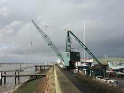
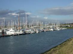
Continue on westwards along the banks for many more miles until they approach and enter Burnham-on-Crouch. The path becomes surfaced as it enters the town and passes the lovely 1930's building of the Royal Corinthians Yacht Club. It continues on, passing the Royal Burnham yacht Club, the Crouch Yacht Club and the Burnham Sailing Club before reaching the Burnham Yacht Club.
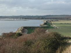
Walk around the yacht club harbour and then continue along the sea bank on the other side. When this reaches the road in Creeksea continue along this road as it curves to the right. Pass a house on the left and then turn left down a footpath that heads across a field before reaching the sea bank once more beside a little creek.
The sea bank continues on north-westwards before leaving the sea bank and climbing up beside the edge of a cliff. From he top of this little cliff there are some nice views back to the east and forwards to the west. Continue down from the cliff and rejoin the sea bank that soon passes the start of Althorne Creek, with the flooded remnants of Bridgemarsh Island on the other side of the creek. The bank diverts inland for a short distance before heading out again and going westwards towards a marina and boatyard at Althorne. Go through the yard and then turn right to head northwards up a track towards Althorne Station, where this walk ends.
Distances
| From | To | Distance (m) | Ascent (ft) | Descent (ft) |
|---|---|---|---|---|
| Tillingham Marshes | Burnham-on-Crouch | 11.4 | 62 | 89 |
| Burnham-on-Crouch | Althorne Station | 4.6 | 174 | 151 |
This makes a total distance of 16.0 miles, with 236 feet of ascent and 240 feet of descent.
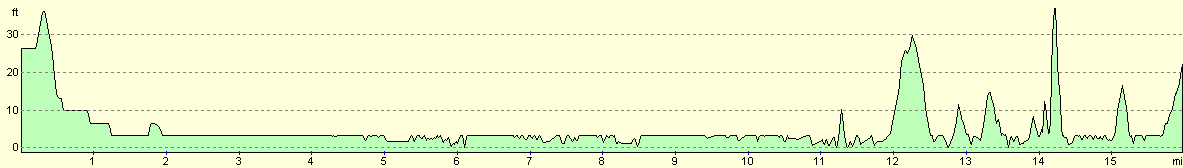
For more information on profiles, ascents and descents, see this page
Accommodation
We stayed at the Creeksea Place Caravan Park, Ferry Road, Burnham-on-Crouch, Essex CM0 8PJ. They can be contacted on (01621) 782387. This was a fairly nice site, which was unfortunately fairy muddy after the rain of the last few weeks. The owner was very nice, and very kindly gave us a donation to our charity, and the site costs about twelve pounds per night with electricity hook-up. The site closes for three months at the end of November, and so we were quite lucky to get on the site, particularly when we could not find any other sites that were open in the area.
Disclaimer
Please note that I take no responsibility for anything that may happen when following these directions. If you intend to follow this route, then please use the relevant maps and check the route out before you go out. As always when walking, use common sense and you should be fine.
If you find any information on any of these routes that is inaccurate, or you wish to add anything, then please email me.
All images on this site are © of the author. Any reproduction, retransmissions, or republication of all or part of any document found on this site is expressly prohibited, unless the author has explicitly granted its prior written consent to so reproduce, retransmit, or republish the material. All other rights reserved.
Although this site includes links providing convenient direct access to other Internet sites, I do not endorse, approve, certify or make warranties or representations as to the accuracy of the information on these sites.
And finally, enjoy your walking!
This walk was mentioned in the following routes:
| My walk around the coastline of Britain |
Nearby walks
| # | Title | Walk length (miles) |
|---|---|---|
| 271 | Fingringhoe to Tollesbury | 16.7 |
| 272 | Tollesbury to Maldon | 17.2 |
| 273 | Maldon to St Lawrence | 16.0 |
|
|

|