Walk #274: St Lawrence to Tillingham Marshes
 |
 |
|
General Data
| Date Walked | 22/11/2002 |
| County | Essex |
| Start Location | St Lawrence |
| End Location | Tillingham Marshes |
| Start time | 08.46 |
| End time | 14.09 |
| Distance | 14.4 miles |
| Description | This was a short but spiritually uplifting walk which has to rank as one of the best of the trip so far, if only for the experience rather than the scenery. |
| Pack | Today I carried my 30-litre Karrimor HotRock rucksack, which was filled with my packed lunch, waterproof leggings, water bottle and a couple of spare shirts, together with the usual assortment of odds and ends. |
| Condition | I feel absolutely fine after this trip, and had absolutely no trouble at all. Even if I had had trouble, I think that my high spirits would have seen me through. |
| Weather | The day dawned sunny after some heavy rain during the night. The first few hours were lovely and sunny, an absolutely marvellous morning, but this was spoilt by a heavy twenty-minute rain shower. Fortunately the sun came out again and that and the light winds dried me off within half an hour. There was another light shower of rain towards the walk, but it was so light and short that I did not even bother putting the hood of my coat up for it. |
| OS map | Landranger number 168 (Colchester, Halstead & Maldon) |
 |
 |
|
 |
 |
|
Map of the walk
Maps courtesy of Google Maps. Route for indicative purposes only, and may have been plotted after the walk. Please let me have comments on what you think of this new format. For a detailed table of timings for this walk, please see the table file.
Notes
Today could well be the best day of the trip so far, not because of the scenery or the weather, but simply because it was probably the most spiritually uplifting day I have had for a long, long time.
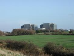
Early on in the walk I passed the two nuclear reactors of the Bradwell power station. which was housed in two rather ugly and unattractive buildings. I was slightly annoyed that I could not find any information about the power stations or any information boards about them - a vast difference to Torness power station where there were nice and informative information boards everywhere. I later found out that this station is an early Magnox-style power station which began operating in 1962.
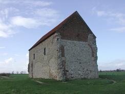
I had read that the Church of St Peter-on-the-Wall to the south of Bradwell is probably the oldest church still substantially complete in the country. Since I was passing right past the church I felt that it would be a shame if I did not go and visit it. I therefore went past a sign stating the Othona Community when suddenly I was approached by a man, who asked me what I was doing. I explained what I was doing, and he invited me to their canteen for a cup of tea. I was in no particular hurry, and so I decided to accept the invitation.
The Othona Community is a group of people working together to form a community. Although it has a Christian base there are members who cannot share a Christian faith. Whilst they made me the cup of tea we chatted about many things, and it was a really, really nice experience as everyone was nice and friendly. More details can be found at www.othona.org/bradwell/.
Whilst I was at Othona I looked through a bookcase to see what they had there. I was absolutely amazed to find a book called 'Walking the edge', by Graham F Jones and ISBN 1-897913-62-1 which is about the author's recent 2000-mile walk around the coastline of England. From the few little glances I saw of it, it is quite a well-written book, and I would like to obtain a copy sometime. It is just a sign of exactly how stupendous today was.
To make matters even better, as I was walking south away from the church there was a little amount of drizzle in the air and when I looked behind me the church was surrounded by a glorious but indistinct rainbow, with the church almost glowing white and red against the dark sky. It was a lovely sight which typifies the day.
The church itself is very interesting - it was built around 654 A.D., which makes it probably the oldest church which is still substantially complete in England. It looks very much like a barn and could easily be passed as such (indeed, for a few centuries it was used as a barn) but closer inspection shows that it is of great antiquity. The building itself is made from the remains of the Roman fort of Othona, and Roman tiles are obvious in parts of the building. The building interior is extremely atmospheric and has a simplicity that is so marvellous in a church. Although I find much church architecture to be fantastic and interesting, you really do not need fancy interiors to worship - all you really need are people.
Terry made a comment tonight that when I mention Sams name my eyes glaze over and I have a longing look on my face. I cannot say whether this is true or not, but what I do know is that I am missing her terribly, and that I love her immensely. I have felt like I have been in love many times before, but now that it has really come I feel like I have been hit in the face with a fifteen-pound sledgehammer. I can be walking along in a torrential rainstorm, with a howling gale blowing the rain straight into my face, and Sam will come into my head and my whole heart and body warms up - such is the effect that she has on me. I feel really soppy mentioning this but it is how I feel about her. She sometimes drives me to distraction (and I daresay that I do the same to her), but just her smile alone can melt the hardness of my heart. If this is not love then I do not know what is.
Today was the first time on the walk that I have had to make a substantial walk inland to get picked up. The section of coast that I am currently on is fairly remote and has no roads going to it, so I had no choice but to walk for a couple of miles to a road where I could meet Terry and Mervan.
Once Terry had picked me up we drove into Burnham-on-Crouch so that we could have a bite to eat. Burnham is a pleasant little town, and I particularly liked the clock tower that was attached to an old school. We tried a pub but they were not serving food, and whilst we were walking up the road to find another pub that served food we found an Internet café. This served food, so we both had a meal there and followed this by a free half-hour in which I read me latest emails.
Directions
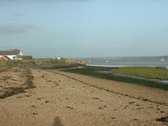
This walk starts off at the car park beside the St Lawrence Inn, in St Lawrence. Leave the car park, not by the road but enter the caravan park behind it. Walk through the park towards the sea bank, and then carefully climb over the fence that is covered with an anti-climb gel. Once on the sea bank turn right and follow the bank as it heads southeastwards. I actually walked along the beach and across the marshes as the tide was out, which probably made for a slightly better walk.
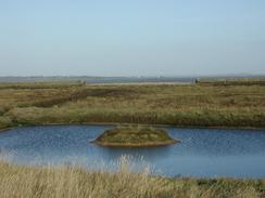
Continue along he top of the sea bank as it heads eastwards before slowly turning to head north-eastwards. The path leaves the sea bank and heads inland alongside fields for a little over a mile where the sea bank has been breached to create new high-level salt marshes. Shortly after the path meets the sea bank one more it meets the marina at Bradwell Waterside.
Once the marina is met turn right alongside it and then left, to head along a road past the marina. When the road reaches the imposing marina tower on the left pass it and then turn left along a footpath that runs alongside the top of the bank once more. Follow this path as it passes the Bradwell nuclear power station and then turns to head eastwards and then southeastwards past Sales Point, where it turns to head southwards.
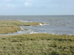
The path continues along the top of the bank as it passes the grounds of the Othona Community and then the St Peter-on-the-wall church. Continue on along the outermost of the seawalls as it heads southwards past the Tillingham Marshes on the right and the Dengie Flats on the left. When the bank turns to the right beside a little outlet called Howe Outfall follow it, and when it turns to the left to head southwards once more continue straight on westwards down a track that leads westwards to Howe Farm. The track curves to the left past the farm and then turns to the right to head westwards past Grange Farm. At this point the track becomes a public road, which ends at a T-junction with another road by a public phone box, where this walk ends.
Distances
| From | To | Distance (m) | Ascent (ft) | Descent (ft) |
|---|---|---|---|---|
| St Lawrence | Bradwell Waterside | 4.8 | 98 | 98 |
| Bradwell Waterside | St Peter's Church | 3.6 | 30 | 30 |
| St Peter's Church | Tillingham Marshes | 6.0 | 33 | 10 |
This makes a total distance of 14.4 miles, with 161 feet of ascent and 138 feet of descent.
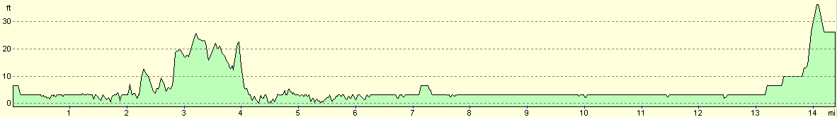
For more information on profiles, ascents and descents, see this page
Accommodation
We stayed at the Creeksea Place Caravan Park, Ferry Road, Burnham-on-Crouch, Essex CM0 8PJ. They can be contacted on (01621) 782387. This was a fairly nice site that was unfortunately fairy muddy after the rain of the last few weeks. The owner was very nice, and very kindly gave us a donation to our charity, and the site costs about twelve pounds per night with electricity hook-up. The site closes for three months at the end of November, and so we were quite lucky to get on the site, particularly when we could not find any other sites that were open in the area.
Disclaimer
Please note that I take no responsibility for anything that may happen when following these directions. If you intend to follow this route, then please use the relevant maps and check the route out before you go out. As always when walking, use common sense and you should be fine.
If you find any information on any of these routes that is inaccurate, or you wish to add anything, then please email me.
All images on this site are © of the author. Any reproduction, retransmissions, or republication of all or part of any document found on this site is expressly prohibited, unless the author has explicitly granted its prior written consent to so reproduce, retransmit, or republish the material. All other rights reserved.
Although this site includes links providing convenient direct access to other Internet sites, I do not endorse, approve, certify or make warranties or representations as to the accuracy of the information on these sites.
And finally, enjoy your walking!
This walk was mentioned in the following routes:
| My walk around the coastline of Britain |
Nearby walks
| # | Title | Walk length (miles) |
|---|---|---|
| 269 | Clacton-on-Sea to Brightlingsea | 18.8 |
| 270 | Brightlingsea to Fingringhoe | 15.2 |
| 271 | Fingringhoe to Tollesbury | 16.7 |
|
|

|