Walk #899: Lincoln to Woodhall Spa
 |
 |
|
General Data
| Date Walked | 16/05/2011 |
| County | Lincolnshire |
| Start Location | Lincoln car park |
| End Location | Woodhall Spa |
| Start time | 07.32 |
| End time | 16.15 |
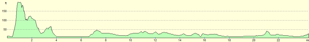
| Distance | 24.4 miles |
| Description | This was a pleasant walk following the Viking Way eastwards out of Lincoln. It was a fairly flat walk aside from the climb up to Lincoln Cathedral at the beginning of the day. |
| Pack | Today I carried my 30-litre Karrimor rucksack, filled with water, my waterproofs, a couple of books and other odds and ends. |
| Condition | I feel a little tird after this walk, but otherwise feel fine. |
| Weather | The day started off wet, with a combination of drizzle and periodic light rain that was blown along by a westerly wind. Things improved during the day, and there was even a few glimpses of the sun towards the late afternoon. |
| OS map | Landranger number 121 (Lincoln & Newark-on-Trent) and Landranger number 122 (Skegness & Horncastle) |
 |
 |
|
Map of the walk
Maps courtesy of Google Maps. Route for indicative purposes only, and may have been plotted after the walk. Please let me have comments on what you think of this new format. For a detailed table of timings for this walk, please see the table file.
 |
 |
|
Notes
It had been a couple of weeks since I had last down a walk, and I was keen to continue my mission along the Viking Way. had walked to Lincoln so far, and the next stretch of over twenty miles was going to be as far as Woodhall Spa, from where a bus could be caught back to the county town. For once I actually checked up on the car parks at my destination and after an early morning drive I parked at a small car park a couple of hundred yards from the railway station; the ticket for a day cost a reasonable £4.
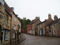
The weather forecast had been for cloudy but dry weather, and like a fool I had believed it. Rain started to fall about halfway to Lincoln, and although it died down there was still a heavy drizzle by the time that I got my kit together and started my stroll through the city. This was surely a shame as Lincoln is a city that demands sunshine. It is a beautiful place and I made slow time as I continually stopped to take as many photos as I could in the grey weather.
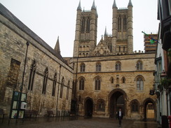
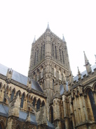
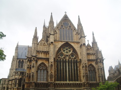
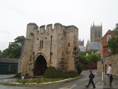
A steep climb took me uphill towards the Cathedral that dominates the city. It is a truly magnificent structure, and I have happy memories from my childhood of being guided around the place by my parents, and of the Lincoln Imp, a carving inside the church that has become a mascot of the city. Sadly I could not afford the time to go in, so I ignored the pealing bells and headed through the drizzle along the grand southern side of the structure.
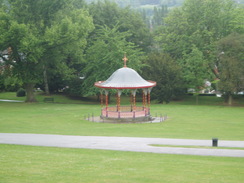
Roads took me down towards the large Arboretum Park. There was plenty to be seen from the path and the park was filled with interesting objects, such as a bandstand, a giant carved lion and even what appeared to be a small circular maze set in low hedges. The OS map seemed to show the next stretch of the walk as being through an area of housing, but instead a good - if sometimes narrow - path squeezed past the backs of some housing and past a hospital. Some good views unfolded down over the valley below, showing how the medieval city had expanded with the industrial revolution.
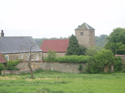
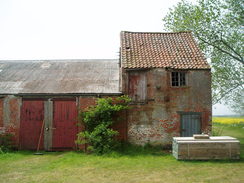
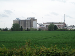
A road led through a large industrial estate, and I decided not to have a bacon butty from the burger van on the roadside, instead getting a couple of chocolate bars that I could scoff on the way. Soon afterwards the path left the urban areas and entered the countryside, initially following a railway line before crossing it. The ground around Greetwell Hall and its small church was very uneven, with great trenches making what looked on the map to be a simple walk more difficult. These look like they must have at some stage been related to buildings, but try as I might I could not work out what they were.
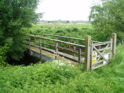
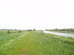
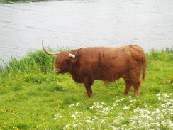
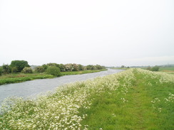
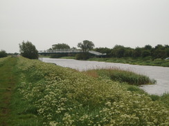
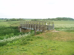
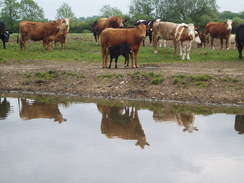
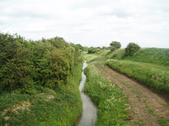
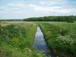
A path led down to the southern bank of the River Whitham, which I had followed earlier in the trail near Long Bennington. Then it had been little more than a small, trickling stream; now it was a broad, arrow-straight watercourse that was flowing lazily towards Boston and the sea. The walk along it was fairly uninteresting, but fortunately the drizzle was coming from behind instead of ahead; a bonus as the wind was becoming increasingly blustery. The wind stopped me from taking too many glances back towards Lincoln Cathedral, which was clearly visible on the hillside in the distance. Three Highland cows stopped chewing the grass to watch me pass, as if they resented my intrusion. Eventually a large metal footbridge that spanned the river came into view.
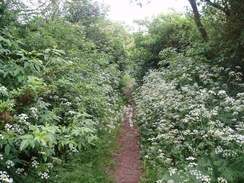
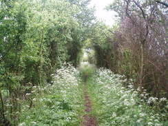
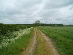
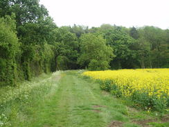
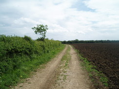
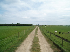
Here the route left the river, choosing to head north past Fiskerton, where a couple waiting for a bus told me the rain was due to end by ten. A quick glance at my watch showed me that it was a few minutes to ten, but the clouds were still heavy and threatening. Fortunately the trail did not stick to the road for long, and instead started along a green lane. This was a pleasant stroll, even when the path narrowed so much that branches brushed against me, soaking my coat. Many of the green lanes and tracks on the Viking Way are badly rutted, but this one was an absolute pleasure to walk along.
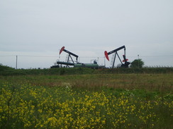
Soon a strange sight became visible to my left; two nodding donkeys sitting in a field. Both were motionless, and a slight hint of heavy oil hung in the air. I had not expected to see oil drilling in Lincolnshire, but the donkeys were far preferable and less intrusive than a wind turbine (which, given the wind, would have been doing good business today). These were part of the Fiskerton Airfield oil well, which started producing in 1998.
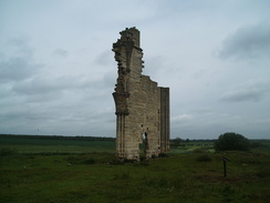
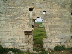
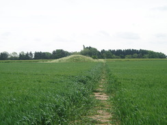
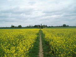
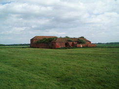
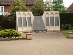
The green lane became a path across fields that ended at the ruins of Barlings Abbey, the only remains of which was one solitary wall that had a large hole at its base. Everything else had gone, leaving lumps and bumps in the field and scattered stone blocks jutting out of the grass. Cows serenely munched the grass around the blocks as if they were channelling the spirits of the monks who once lived here.
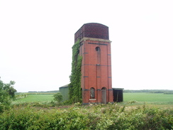
More paths and roads took me further northeastwards, before the trail chose to strike southwards past Stainfield. Eventually it approached the ruins of Bardney Abbey; as this was slightly off the trail I did not bother visiting it and instead walked past a fairly striking water tower.
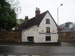
A pub was marked on the map in the village of Bardney, and I diverted off the trail to see if this was open. As I suspected it was not, so I returned to the trail and took a good track southeastwards. This was in company with a new cycle path that mostly follows he old railway line that ran between Lincoln and Boston; this path soon diverted off to the right, leaving the Viking Way to skirt the side of Southrey Wood. I was starting to feel a little tired by this stage, and I was hopeful that I would find a place to stop in the tiny village of Southrey. However as I entered the village a local man told me that the pub was still open for business, but, typically, it was shut on Mondays!
My feet were starting to ache slightly from the stroll so it seemed like a good idea to stop for a few minutes. There had been no rain, so I moved a few yards off the road into a field and took off my boots to allow my feet to cool down a little. A hedge kept the worst of the wind off me as I scoffed down a few slices of homemade fruitcake, a very welcoming trail food.
Time was starting to press now; the last bus from Woodhall Spa back to Lincoln was just before five, and so I had to make sure that I got there before then. The trail took paths, first northeastwards, then southeastwards, crossing roads to reach Stixwould, where there had once been yet another abbey. I did not spend long looking around as I was hopeful that I could catch the next bus - I had about forty minutes to walk a little over two miles. I pressed on as the path headed south, and I reached the road on the outskirts of Woodhall Spa about a minute before the bus was due.
The problem was that I had little idea where the bus stop was. Fortunately I saw one a few yards down the road, so with weary feet I jogged the distance only to find that I had written down the wrong bus times and it had left ten minutes before. Slightly dejected, I strolled into the centre of the town, bought myself a compensatory ice cream and waited for the next bus. When this came it turned out I was the only person on it, and this continued to be the case it wound its way around the country lanes, eventually dropping me off in the centre of Lincoln.
It took me a while to drive back to Woodhall Spa and to find the campsite, but when I did I was greeted with a friendly, attractive and efficient place. It was still sporadically raining, so I picked a dry gap in which to pitch my tent. All in all it had been a good - if long - day's walk.
 |
 |
|
Directions
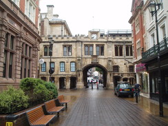
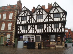
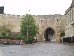
This walk starts off at the car park on Chaplin Street, which is at SK973705 to the south of the city centre. Leave the car park and turn left down Chplin Street; at its end turn right and follow the High Street northwards through the city, immediately passing the railway station on the right and passing under the Saltergate. Shortly after crossing the B1308 after 0.4 miles turn half-right along the Strait. This curves slightly to the left as it becomes the aptly-named Steep Hill. When the Magna Carta pub is reached on the right (with the castle on the left), turn right to head down a road that leads towards and under an archway to reach Lincoln Cathedral.
The trail heads eastwards, following Minster Yard with the mass of Lincoln Cathedral to the left. When this road ends at a mini-roundabout, turn right to follow Pottergate southeastwards towards the archway of Pottergate. Keep this to the right as the roads ends at the A15. Turn left along this road, and then turn right down Upper Lindum Street.
This curves to the right to head south, soon ending at a T-junction with Lindum Terrace. Turn left and follow this eastwards for 100 yards; just before Eastcliff Road comes in from the left, turn right through a gateway to enter the Arboretum Park. Take an obvious path as it winds around before reaching a broad terraced track called Arboretum Path beside a fountain. Turn left to start following this path eastwards through the park.
At the eastern end of the park go through a gate to continue eastwards along another path; this goes through another gate to end at Milman Road. Turn right to head downhill for a few yards and then turn left to take a narrow surfaced path that squeezes past a house on the right. This continues for half a mile as it passes the ends of rows of houses on the right before opening out and passing the grounds of a hospital on the left. The path heads on, ending at Hillside Avenue. Turn left along this road for a few yards to another junction, and then turn right to continue eastwards along Tower Drive. This heads downhill to end at the B1303; turn left along this road for a few yards and take the first road off to the right, Crofton Road. This heads eastwards for a quarter of a mile through an industrial estate, and when it ends turn right to head south down Dowding Road. When this ends, turn left to cross an area of grass, then head down a few steps to a hedge.
On the other side of the hedge turn right to head a short distance to a railway line. Then turn left and continue on with the railway line on the right. After a couple of hundred yards turn right and go through a pedestrian gate to carefully cross the railway line on a level crossing. Go through the gate on the other side and turn left to head eastwards with the railway line on the left. After half a mile the path passes Greetwell Hall on the right; here it angles away to the right to head across rough grass for a short distance and cross a cattle grate to reach a bend in a road at TF014716. Join the road for a few yards and then turn right to head diagonally southeastwards across a field towards the far corner.
At the bottom of the field turn half-right to squeeze through the hedge and continue southwards with a hedge on the left and a fence on the right; aim for a church on the hillside in the distance. After a fifth of a mile the path crosses a footbridge over a stream to reach the northern bank of the River Whitham. Turn left and cross a metal clappergate to follow the broad bank eastwards for 2.5 miles until it reaches a footpath at TF058715, with a large metal footbridge to the right.
Turn left to join a road, immediately crossing a bridge over a stream. Head north for a quarter of a mile until the road ends at a T-junction with Ferry Road, immediately to the east of Fiskerton.
Turn left along Ferry Road, and then take the first road to the right, Hall Lane. This immediately curves to the right and then the left before settling on a northerly course. As the road curves to the right after a quarter of a mile continue straight on to head northwards along a green lane called Long Close Lane, initially with a cottage on the right. This lane slowly curves to the right to take a more northeasterly course. Continue straight on as the track jinks to the right and then immediately to the left to continue on a rough easterly course. The track ends at TF076734 and is replaced with a footpath that cuts eastwards across a field. At the end of this field cross a footbridge over a stream and turn half-left to continue across a couple of fields with a hedge on the left; the hedge slowly curves to the before ending at a road at TF086736.
Turn right to head southeastwards until the road ends after about 100 yards at Low Barlings. Turn left to head through the farm, passing a barn on the left, and just before the farmhouse is reached turn right through a gate to enter a field. In the field turn left to head eastwards past the solitary remaining wall of Barlings Abbey to reach a footbridge over Barlings Eau. On the other side of the bridge continue with a drain on the left. After about two-thirds of a mile the track curves away to the right; do not take this, but head across a grassy area between the track on the right and the drain on the left. Go through a metal gate to reach a bend in a road near Court House Farm at TF095745.
Follow the road northeastwards for a third of a mile until the road curves to the left; here turn right through a metal gate to follow a bridleway southeastwards across three fields with a fence on the right. At the end of this field go through a gate and cross a ditch via a footbridge. Head straight across this next field, passing the end of a hedge on the right to enter a third field. The path eventually joins a hedge starts on the left before ending at another road at TF108739. Cross the road and head for a few yards along a rough grassy area to cross Sambre Beck, before turning left to follow the stream northeastwards, with the beck on the left. After a fifth of a mile turn right, heading across a field for a few yards before joining Foxhall Wood on the right. Follow the edge of the woodland as it curves to take a southerly course before ending at a road in Stainfield, with a cottage on the right.
Turn right and follow the road as it winds southwestwards for a quarter of a mile. Immediately after passing the church of Stainfield Hall on the left, turn left to head south across a field (ignore the track off to the left). This crosses a couple of metal clappergates between fields, heading slightly uphill before crossing a stile to reach a road at TF111727. Turn left down the road past a few houses on the right, and then turn right along another footpath. Do not take the track that runs southwestwards alongside the hedge and instead turn half-left to head due south across another field, paralleling some power lines on the right. The path crosses a footbridge over a ditch before going through a gap in a hedge and rejoining the same road.
Turn right to head south along this road; at a T-junction turn left. A lay-by is reached on the right ater two-thirds of a mile. Pass this and then turn right to head up a track towards the farm, crossing a drain on the way. The path heads on through the farm to enter a field; immediately turn to the left to head southeastwards with some farm buildings, a hedge and then a paddock on the left. After a short distance the path jinks to the left alongside the paddock to reach a corner of a field. Here turn right to follow a hedge south-southeastwards for a little under half a mile.
The path crosses a drain on a bridge and continues in the same direction; shortly after this it squeezes through a hedge and heads straight on across a field. When a faint track is reached with a mound of earth on the left, turn right to head west-southwestwards along this track, with a hedge soon starting on the left. After 0.4 miles this ends at Abbey Road with a water tower to the left. Turn left to head south-southeastwards along the road towards Bardney.
Carron Close is passed on the left after nearly half a mile; immediately after this turn right down a track. This heads southwestwards between hedges; the hedge on the right soon ends and the path continues on with the hedge on the left. This hedge ends as the path crosses a track and passes through a clappergate in a hedge; continue straight on across the field until it reaches another hedge. Go through another clappergate and then turn left to follow this hedge southwards with a fence on the right. It soon reached another clappergate; cross this and turn right as the path squeezes between houses to end at the B1190 road in Bardney at TF115692.
Turn left to head northeastwards along this road for a short distance, and then turn right down an unsurfaced track with a fence on the left. It continues southeastwards between fields, passing some buildings on the right before curving slightly to the left to approach Southrey Wood.
When a track junction is reached immediately before the wood continue straight on with the trees on the left. When a sewage farm is passed on the left the track becomes rougher. Keep the trees on the left past the woodland. When the trees end the track curves to the right; after a few yards turn left to join a track called Westfield Road. Follow this south-southeastwards; after a quarter of a mile it curves to the left, and then it curves to the left once more to head in a more easterly direction.
It passes a farm on the left; after this farm turn right down High Thorpe Road. This curves to the left to wind eastwards for a fifth of a mile through Southrey until it ends at a T-junction with Ferry Road. Turn left to head north along this road for a few yards, and then turn right through a gap in a hedge to join a track.
Head eastwards along this track; at the end of the first field it crosses a drain and angles slightly to the left to head northeastwards across a field to reach a footbridge over another drain. Cross this and continue on along a track with a hedge on the left. Go through a gate to pass Abbey Warren Farm on the left and then go through second gate to continue northeastwards along the good track. Half a mile after the farm the track curves to the right to head southeastwards for nearly half a mile until it ends at Campney Lane at TF156672.
Cross Campney Lane and continue straight on along a track. After a few yards this curves slightly to the right and then the left, following a hedge on the left. Pass a gate through a hedge and continue southeastwards across a field; when this ends go through a hedge to join a track that heads east-southeastwards towards Willow Farm. At the farm the track curves to the left to head into the farm; here continue straight on through a gate to skirt south of the farm before the track is rejoined. Continue on until a road is reached at TF167665.
Turn left along the road, and as it reaches a T-junction after a few yards turn right down another road. This soon crosses the Catchwater Drain at Duckpool Bridge; after half a mile it curves to the south to enter Stixwould. As the road swings to the left, turn right to head south along Station Road for a third of a mile. Follow the road as it swings to the left to head eastwards for another third of a mile to another road junction.
Turn right to head south down this road for a couple of hundred yards. As the road starts to swing to the left turn right down a track, immediately passing a house on the left. This track crosses a stile to emerge into a field; turn left to follow another track south with a hedge on the left. This crosses a ditch on a bridge; on the other side of the bridge turn half-right to join a footpath that heads southwestwards across a field, aiming for a wooden clappergate and bridge over another ditch to the west of a barn.
Cross this bridge and follow the path southwards as it runs between fields for a quarter of a mile until the northern edge of some woodland is reached. Turn left to keep the woodland on the right, and as the corner of the woodland is reached turn right to head south, still with the trees on the right.
Once the trees end go through a gap in a hedge and turn left to follow a path east-southeastwards between fields. When some trees are reached ahead, turn right to head southwestwards with the trees on the left. After a fifth of a mile turn left to head through the band of trees and reach a track by a bridge over a ditch. Continue on south-southeastwards, immediately crossing the bridge and continuing on along the track for a third of a mile until it reached Green Lane at TF182630.
Turn right along this road for a few yards and then turn left to head southeastwards along a rough path between hedges, It crosses two roads before ending at the B1191 Witham Road. Turn left and follow the B1191 northeastwards for 0.4 miles until a crossroads is reached with the B1192 in Woodhall Spa at TF192630. Carefully cross the crossroads and continue on until a Co-Op store is reached on the right, where this walk ends.
 |
 |
|
Distances
| From | To | Distance (m) | Ascent (ft) | Descent (ft) |
|---|---|---|---|---|
| Lincoln car park | Fiskerton | 6.9 | 325 | 315 |
| Fiskerton | Bardney | 8.8 | 112 | 125 |
| Bardney | Woodhall Spa | 8.8 | 102 | 85 |
This makes a total distance of 24.5 miles, with 539 feet of ascent and 525 feet of descent.
For more information on profiles, ascents and descents, see this page
Accommodation
I spent the night at the Woodhall Spa Camping and Caravanning Club site. This is situated a couple of miles out of the town. The facilities at the site were good, and the toilets and showers were clean and tidy.
Transport
Hourly busses run between Woodhall Spa and Lincoln; Lincs Interconnect Service 5, which runs between Boston and Lincoln.
 |
 |
|
 |
 |
|
 |
 |
|
 |
 |
|
 |
 |
|
 |
 |
|
 |
 |
|
 |
 |
|
 |
 |
|
 |
 |
|
 |
 |
|
 |
 |
|
 |
 |
|
 |
 |
|
 |
 |
|
 |
 |
|
 |
 |
|
 |
 |
|
 |
 |
|
 |
Disclaimer
Please note that I take no responsibility for anything that may happen when following these directions. If you intend to follow this route, then please use the relevant maps and check the route out before you go out. As always when walking, use common sense and you should be fine.
If you find any information on any of these routes that is inaccurate, or you wish to add anything, then please email me.
All images on this site are © of the author. Any reproduction, retransmissions, or republication of all or part of any document found on this site is expressly prohibited, unless the author has explicitly granted its prior written consent to so reproduce, retransmit, or republish the material. All other rights reserved.
Although this site includes links providing convenient direct access to other Internet sites, I do not endorse, approve, certify or make warranties or representations as to the accuracy of the information on these sites.
And finally, enjoy your walking!
Nearby walks
| # | Title | Walk length (miles) |
|---|---|---|
| 600 | Newark on Trent to Lincoln | 19.5 |
| 608 | Market Rasen to Lincoln | 24.1 |
| 896 | Ancaster to Lincoln | 20.6 |
|
|

|