Walk #717: A circular walk from Dunstable to Ivinghoe Beacon
 |
 |
|
General Data
| Date Walked | 05/03/2006 |
| County | Bedfordshire, Buckinghamshire |
| Start Location | Dunstable |
| End Location | Dunstable |
| Start time | 09.45 |
| End time | 16.32 |
| Distance | 18.7 miles |
| Description | This was a walk of two halves; the first half taking the high ground of the Chilterns to Ivinghoe Beacon, and the second half going over the lower, flatter ground back to Dunstable. |
| Pack | Today I carried my 30-litre Karrimor rucksack filled with my waterproofs, two litres of water, a book and various other odds and ends. |
| Condition | My right knee ached a little at times during the walk, although it was never very significant. Aside fromt his I had no other problems, and this allowed me to enjoy the wonderful walk all the more. |
| Weather | The day was bright and sunny, with a few cloudy periods at times. It was a cold day, and there was a breeze that meant that exposed locations were very chilly. The skies were clear, however, and this allowed for some expansive views over the plains to the north. |
| OS map | Landranger number 166 (Luton & Hertford, Hitchin & St Albans) and Landranger number 165 (Aylesbury & Leighton Buzzard, Thame & Berkhamstead) |
 |
 |
|
 |
 |
|
Map of the walk
Maps courtesy of Google Maps. Route for indicative purposes only, and may have been plotted after the walk. Please let me have comments on what you think of this new format. For a detailed table of timings for this walk, please see the table file.
 |
 |
|
 |
 |
|
Notes
The weather forecast for today was for sunny, clear weather, and so instead of doing the local walk that I planned I decided instead to go somewhere a bit more sunny. A quick look on the map made me decide to visit Ivinghoe Beacon, and I soon had a circular walk planned from Dunstable, the first half of which I had done before at the end of 2000. The drive down took longer than I had expected it to take, and as I set off slightly late the long-stay car park in Dunstable was fairly full, although I was glad to find that it was free on Sundays.
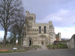
It did not take me long to get my kit together, but before I set off I made a little diversion across the car park to see the frontage of Dunstable Priory, an unusual church that looked remarkable incomplete, with a large arched door on the right and a smaller one on the left. It turns out that the larger door was originally a central one with a mirror-image smaller door on the right, but that part of the building has since been demolished. The route through Dunstable was not easy to find, although the signposts helped me find the path that led to a short-stay car park on the other side of the A5, where the public toilets came in handy after the drive. From here a track took me on passing a cemetery before reaching a road. Her some teenagers asked me why I was walking, and it was obvious that as I tried to explain that they just could not understand why someone would want to put a rucksack on their back and walk twenty miles in a day, just as I cannot understand why they would want to be hanging around on street corners.
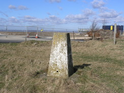
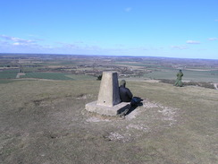
A path led on uphill, initially between hedges before crossing a golf course, from where there were some good views to the northwest and northeast over Dunstable. There were few people on the golf course, and the gradient was slight so I made good time up to the main road on Dunstable Downs, where there were some superb views to be had to the north and west, so I stopped for a few minutes to let them soak in. As I wanted to visit the trig pillar on Dunstable Downs (the highest point in Bedfordshire) I left the Icknield Way here and headed up the road for a short distance to the trig pillar, next to which there was a new building under construction.
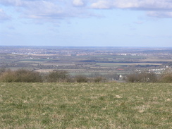
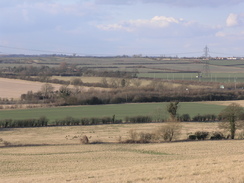
A track led on with some good views over the plains to the north , which sadly ended when the track entered some woodland for a period before emerging and heading down towards the village of Whipsnade. On the way I passed Whipsnade Tree Cathedral (I have no idea what that is!), before heading on along the Icknield Way. This soon started skirting the high fence that marks the boundary with Whipsnade Wild Animal Park, and through the fence I could see Wallabies frolicking on the grass. This sight cheered me up, and I enjoyed the occasional glimpses of the animals that I got through the fence as I walked. The fence went through a series of turns, and in the corner of one of these there was a herd of deer crowded around a little hut, and although the views were sadly obscured slightly by two fences, they were still a lovely sight.
After leaving the fence behind the path crossed a golf course, and whilst I normally have no problems crossing these I had a little trouble on one fairway on this course. To my left were four people on a tee, and one of them had just teed off. The fairway was about twenty yards across, and as one of the other men stooped down to put his ball on the tee I started to cross, knowing it would take him a minute or two to get ready to hit the ball. Once I was halfway across one of the men called out, and although he was still not in a position to strike the ball I jogged back across to the safety of the hedge. I had to wait for a few minutes whilst two of the men teed off, and one of the balls landed only six feet away from me with a distinct thud - I could easily have been across the fairway if they had not called out.
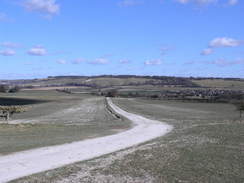
Near the clubhouse I came across a group of other walkers, and after chatting to them for a few minutes I headed down a steep path to a road, after which a muddy and very slippery path led on to the A4146 road in Dagnall. I had to follow this road for a short period, but there was a pavement all the way until the pub was reached, which unfortunately was not yet open. Next came a long track that headed southwestwards, and as it slowly climbed uphill there were some good views to the north, and to the west there was the ridgeline of Ivinghoe Beacon. At Hog Hall the track ended and a path continued on, the views becoming more expansive as it rose; to the right there was a herd of deer in a field. Once Ward's Hurst Farm was reached the nature of the path changed as it plunged into a path of dark woodland, descending downhill before eventually emerging out into the sunshine right before the start of the ridge.
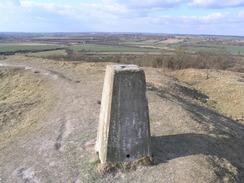
The views up towards the ridge were superb, and so I stopped to take some photographs that ended up making a good panorama. The climb up onto the ridge was easy, and after passing a stone that marked the convergence of the Ridgeway national trail and the Icknield Way, I headed on up to the summit. At the top I was exposed to the full fury of the stiff breeze, and I instantly started to feel quite chilled by it despite my hat and fleece. The top was crowded with people, including some people flying remote-controlled gliders off the ridge, whilst high above them in the blue sky their full-size brothers glided elegantly overhead. The views were lovely, but I was really feeling chilled and so after taking a few photographs I headed off down a path that led along the ridge, before dropping down another steep one to a road.
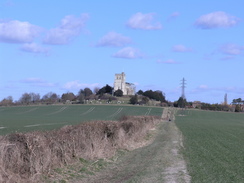
A sign stated that there was a pub in Ivinghoe Aston, but the footpath that I was to take headed off before the village was reached. The footpath was a pleasant and easy walk, following a track, and the final climb up towards Edlesborough church was very nice, with the church clowly growing in size as I approached. The Nave of the church was covered in scaffolding that spoiled the photographs somewhat, but I was pleased to see that on the other side of the road to the church was a pub, the Bell. I entered this and had a pint of Bass whilst I watched the cricket (the last day of the South Africa versus Australia test) and scoffed down a packet of crisps. The pint was very nice, but I ignored the temptation to have another and started walking on down the road through the village. On the way I passed a young man carrying a Bergen on the other side of the road, and it turned out that he was an army man who was doing a similar circular walk to me, except in the opposite direction.
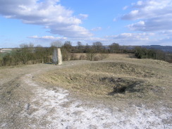
The road led on into Eaton Bray, and led to another bridleway and footpath that headed on into the village of Totternhoe. The footpath was dominated by an abrupt hill straight ahead, and I was soon climbing this via a track that led up to the top of Totternhoe Castle. The trig pillar stands right on top of the motte, the white of the chalk path contrasting sharply with the dark greens of the grass. The views from the pillar were superb in most directions, and although it was chilly in the wind it was nowhere near as bad as it had been on Ivinghoe Beacon. I took some more photos and admired the view fro a while, before heading across the bailey, crossing three defensive ditches on the way. Although only the motte mound remains of the castle it is till an impressive location, and was particularly nice to visit in the sunshine.
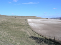
The track descended downhill and it was obvious that the whole area to the north of the castle has been extensively quarried in the past, with a flat plain ending on a couple of sides with bright chalk cliffs where the hillside had disappeared. Another track took me on towards a works, and another one on towards Sewell. Here I climbed up onto an old railway embankment to find a cycle path (not marked on the map) running along the top. It was tempting to follow this into Dunstable,but as this would have shortened the walk I decided to walk on along the road that slowly climbed uphill from Sewell, and from the top of the hill there were some expansive views to the north.
The road ended by the A5 at Chalk Hill, and a boring walk followed along the A5 through a deep cutting, and I was glad that there was a pavement beside the road. The outskirts of Dunstable were not very interesting, the only building of note being an attractive school to the left. Eventually I reached the junction with the A505, where a plaque on a building announced that this used to be the site of Queen Eleanor's Cross, marking one of the places where the funeral cortege of King Edward I'st Consort rested overnight in 1291. Shortly after this I reached my car once again, and I was disappointed to find that the walk was under twenty miles in length - I was hoping that it would have been that length. All in all it was a highly enjoyable walk, with some great views from the high points of the walk.
Directions
This route follows the Icknield Way for the first half of the day, excepting a section on Dunstable Downs where I went to visit the Trig point, which is Bedfordshire's highest point. The walk starts at the long-stay car park by the Priory in Dunstable, just off the A505. Turn left onto the A505 and then left again down the A5(T) for a few yards, until just before a clock tower is reached, where a sign takes you to the right along a path that leads through a car park. Pass a Salvation Army building and continue on along an insignificant gravel track, which soon becomes wider and paved beside a cemetery. At the end of this road turn left to climb up a slight hill. When this road curves sharply to the left continue uphill along a narrow track that soon brings you out onto some open land that houses a golf course. Pass the golf course clubhouse and continue in a roughly southerly direction until the path meets the B5451 road.
The Icknield Way continue on over the road past the viewpoint, but as I wanted to visit the trig point at Bedfordshire's highest point, I turned left up the road for a short distance. Pass a minor road junction and when the road bends slightly to the left a farm track leads off to the right. At the junction of the road and the farm track is the trig pillar. Turn right down the farm track as it leads towards Chute Farm. Pass under two high-tension power lines and head towards an area of woodland. The path skirts under a tall communications mast before entering the woodland along a track; this heads south through the woodland for a short distance before emerging to meet another track near Chute Farm.
Follow this track as it heads southeastwards; it passed the farm on the right and some houses on the left, before the path diverts off to the left to enter a small area of common land, which it skirts as it parallels the road, which it joins again for a few yards before heading off to the right, heading away from the road for a few yards before turning to the left to skirt the tree cathedral at Whipsnade and reaching the B4540.
Turn right along the road for a short distance and then turn left to descend down to a track that leads to the southeast. Turn left down this track as it skirts to the left of a chain link fence, behind which is Whipsnade Wild Animal park. When the fence turns to the right, leave the track and take a footpath that heads off to the right beside the fence and continues southwards.
Continue following the fence as it weaves left and right slightly for about a mile. The path then leaves the fencing and the park and heads southwestwards through a golf course. Follow the signs through the golf course (taking care of people teeing off and flying golf balls). The path turns to the right to head northeastwards past the car parks for the golf course and enters some woodland, where the path descends steeply to meet a road. Turn right down this road for a short distance and then left down a footpath that leads past fields to meet the A4146 in Dagnall. Turn right down this road for a short distance, cross over a roundabout between the A4146 and B4506. Pass a pub and continue until you meet a track leading off to the left.
Turn left down this path, and follow it as it heads straight to the southwest past the turnoff for Dagnall Farm. The track then starts to climb uphill past some woodland and emerges out by Ward's Hurst Farm. On the outskirts of the farm the path turns right by a pond and enters some woodland, where it starts to descend quite steeply, but fortunately there are steps down the steepest sections. At the bottom of the hill the path meets the edge of the woodland and some fields. The path angles in slightly away from the edge of the woodland and is easy to follow as it goes through the wood. When it emerges the path heads slightly uphill and then angles to the south-northwest, where it starts to climb uphill to meet a minor road. At this road turn right and head north over a small hill, before descending and then climbing again to the top of Ivinghoe Beacon.
From the trig pillar at the beacon turn right to head eats along the ridge for a few yards, descending slight until a stile is reached. Here turn left and head down a steep footpath that heads downhill to the north, entering some scrubby woodland before ending at the B489 road. Carefully cross the road, and on the other side a road junction leads off. Follow this road as it heads northwestwards for about a kilometre, and just before the village of Ivinghoe Aston is reached a bridleway heads off to the right. Turn right and join this bridleway as it follows a track northeastwards, descending to cross a small stream before climbing uphill once more to reach the A4146 road by Edlesborough church.
Cross the A4146 road and head straight on along another local road that heads northeastwards for about half a mile before curving to take a more northerly course past Moor End and ending at a T-junction with another road in Easton Bray. Turn left along this road and follow it northwestwards; pass the church in the left and soon afterwards at a complex junction turn sharp right along a minor road. This heads eastwards past some houses, and immediately after some old greenhouses on the left turn left and join a bridleway. This heads northeastwards, and is easy to follow; the bridleway soon ends but a footpath continues on, crossing a stream before ending at a road in Totternhoe.
Turn left along this road and follow it northwestwards for a couple of hundred yards; shortly after a road comes in from the left turn right along a track that passes a livery yard on the left before climbing further uphill, curving to the right and, shortly afterwards, to the left. At this latter bend continue straight on along a steep path that heads uphill for a short distance to reach the trig pillar standing on the motte of Totternhoe Castle. From the pillar follow a path that heads slightly north of east, crossing the bailey and three defensive ditches before reaching the track once again. Follow this track as it heads downhill in a rough easterly direction, and near the bottom of the hill after a sharp left-hand bend a junction with another track is reached.
At this junction turn left and follow another track that heads northwestwards for about half a mile though an area of old quarry workings; the track approaches some large works buildings, and when a track is reached on the right turn right and follow this new track as it heads eastwards. This is easy to follow although tough underfoot; after about a mile a bridge is reached on the let, taking a footpath under an old railway line. Turn left and head under this bridge, which leads out onto a road in Sewell. Join this road and follow it as it heads northeastwards for a little under a mile until it ends at a T-junction with the A5 at Chalk Hill. Turn right and follow the A5 southeastwards for a couple of kilometres; there is a pavement that make the walk safer. Once the junction with the A505 is reached at Queen Eleanor's Cross turn left to head down the A505 for a few yards, before turning right to head up the access road to the car park, where this walk ends.
Distances
| From | To | Distance (m) | Ascent (ft) | Descent (ft) |
|---|---|---|---|---|
| Dunstable | Dunstable Downs | 2.0 | 331 | 3 |
| Dunstable Downs | Ivinghoe Beacon | 6.9 | 636 | 701 |
| Ivinghoe Beacon | Eaton Bray | 3.8 | 121 | 525 |
| Easton Bray | Dunstable | 6.0 | 577 | 436 |
This makes a total distance of 18.7 miles, with 1665 feet of ascent and 1665 feet of descent.
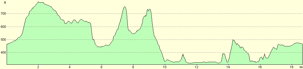
For more information on profiles, ascents and descents, see this page
Disclaimer
Please note that I take no responsibility for anything that may happen when following these directions. If you intend to follow this route, then please use the relevant maps and check the route out before you go out. As always when walking, use common sense and you should be fine.
If you find any information on any of these routes that is inaccurate, or you wish to add anything, then please email me.
All images on this site are © of the author. Any reproduction, retransmissions, or republication of all or part of any document found on this site is expressly prohibited, unless the author has explicitly granted its prior written consent to so reproduce, retransmit, or republish the material. All other rights reserved.
Although this site includes links providing convenient direct access to other Internet sites, I do not endorse, approve, certify or make warranties or representations as to the accuracy of the information on these sites.
And finally, enjoy your walking!
Nearby walks
| # | Title | Walk length (miles) |
|---|---|---|
| 127 | Hitchin to Luton | 13.2 |
| 129 | Dunstable to Tring | 14.1 |
| 130 | Tring Station to Hemel Hempstead Station | 8.0 |
|
|

|