Walk #127: Hitchin to Luton
 |
 |
|
General Data
| Date Walked | 02/12/2000 |
| County | Bedfordshire, Hertfordshire |
| Start Location | Hitchin |
| End Location | Luton Station |
| Start time | 08.40 |
| End time | 13.00 |
| Distance | 13.2 miles |
| Description | This was a pleasant walk following the Icknield Way south-westwards from Hitchin, including two Trig points with lovely views. |
| Pack | I carried no pack today. |
| Condition | I feel fine after this walk, and had no problems of any kind. My feet are fine as well, probably because I used my other walking boots, so I did not suffer from soreness in the underside of them. My shoulders are also okay, due to the fact that I did not carry any pack with me. |
| Weather | Today's weather was quite reasonable. It attempted to spit with rain at on stage, but this did not develop into anything. Fortunately it was not too cold, although when the medium-strength wind caught me it was quite chilly. |
| OS map | Landranger number 166 (Luton & Hertford, Hitchin & St Albans) |
 |
Map of the walk
Maps courtesy of Google Maps. Route for indicative purposes only, and may have been plotted after the walk. Please let me have comments on what you think of this new format. For a detailed table of timings for this walk, please see the table file.
Notes
Before I set out on this walk I decided to take no pack with me, and to carry everything that I needed in my coat. There were two reasons for this; firstly I did not need to carry much stuff with me on such a short, local walk; and secondly my right shoulder had not fully recovered after my walks of the previous weekend. Hopefully things will be fully better in time for my next walk, as walking without a pack does not keep me as fit.
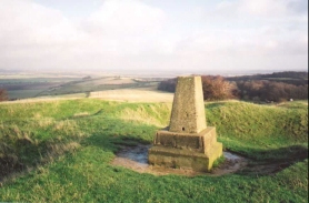
This was a lovely walk, with great views being available from both of the Trig points that were encountered; in particular the ones from the 172-metre high Deacon Hill were very spectacular. It is nice to know that even in an area which has such a high population density beautiful views can still be found. The next section of the walk westwards from Luton to Dunstable Downs and onto Ivinghoe Beacon should also be very attractive.
I had planned for this walk to end at the Luton Leagrave station, where I would catch a train one station south to the main station in Luton. However because I was under very tight timescales (it was my Christmas party in the evening, which I had to get ready for) and the situation with the trains, I decided to walk down to the main Luton station, bypassing Luton Leagrave.
The going today was very muddy in places, but not as bad as the previous three walks had been. On the places where chalk surfaces were exposed they were quite slippery, in particular some sections of the Icknield Way heading up the hill from beside Deacon Hill to the Treasure Grove car park. The worst section for mud was the bridleway heading from Ickleford to Pirton, which in a few places was standing water from one side of the path to the other. Unfortunately I doubt that the ground will get any better for all of the winter, as the ground is well and truly sodden after the wet autumn that we have just had (indeed, apparently it was the wettest autumn on record in England and Wales).
I parked at Woodside car park in Hitchin, which is near the city centre and cost two pounds for the whole day. Hitchin itself has quite a nice centre, with some quite attractive (although not very historic or architecturally noteworthy) buildings. Luton however, is quite the opposite, modern, ugly and concrete, although the shopping centre was quite nice).
Directions
The first stage of the walk is to head northwards out from Hitchin towards the church in Ickleford. This is all road walking, and I started off by going into the city centre from the car park in Walsworth Road and heading down Hermitage Road. I then turned right down Bancroft Road past a parade of shops to the Nightingale Road. Cross over and head up Ickleford Road, which becomes Whitehurst Avenue after the junction with Bearton Road. This comes out onto Strathmore Avenue opposite a company called Webbs Spare Parts.
Turn left down Strathmore Avenue and then walk to the end. At the T-junction opposite Strathmore Infant School turn right down Old Half Way. This eventually becomes Arlesley Road as it heads into Ickleford. At a roundabout near the church turn left down Turnpike Lane. Cross the A600 and follow Westmill Lane, and then turn right and follow a bridleway northwards. After a short distance this turns westwards and heads along a path that soon becomes an unpaved track into Pirton.
The track rises up a slight hill on the outskirts to Pirton, and eventually becomes a road calls Hembridge Way. At the end turn left down Walnut Tree Lane, and almost immediately right through a kissing gate past the church. Beside the church is an mound which was part of an old Motte and Bailey, which was probably part of an ancient fort. The way passes between the mound and the church onto a road. Turn left down this road and follow it as it bends past Great Green. When the road curves sharply to the right at a junction continue straight on down an unpaved track.
This track continues in a south-westerly direction before bending to the south around the western edge of Tingley Wood. The track then meets up with the B655. Turn right down the B655, and just before a right-hand bend in the road turn left down another track that heads uphill. About half a kilometre up this track a stile is in the hedge to the right. This stile leads to a path that heads across some access land and up to the Trig Point on the top of Deacon Hill (172 metres), which has some wonderful views to the north and northeast, and is well worth a visit.
The track continues past the stile and heads up to the top of Telegraph Hill. It then descends down an easy track to the Treasure Grove car park at TL10283. Exit the car park and follow the road that goes straight on. When the road bends sharply round to the left by a farm building after half a kilometre continue straight on down another track, and follow this for a kilometre until just past a golf course on the left. Here a signpost for the Icknield Way denotes where the northern branch splits off from the southern branch, which we will be following.
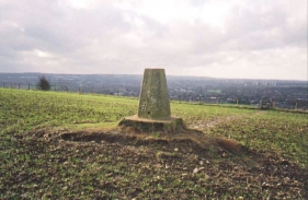
Turn left off the track and follow a footpath for a short distance across the golf course and into some woodland. The path heads uphill onto the top of Galley Hill. From here it descends in roughly a southerly direction. The path meets a badly rutted and muddy green lane called Dray's Ditched, which it crosses and heads uphill towards the summit of Warden Hill. the path follows the western side of the fence, although a stile allows access to the summit of Warden Hill (195 metres), which has some interesting views to the west and southwest over Luton.
Continue on following the fence and descend down the hill. Near the bottom the path heads of sharply to the right and heads westwards into the outskirts of the city. The path enters a housing estate and meets a road. Turn left down this road to a T-junction with another road. Opposite the junction is a wide, surfaced path. Head down this in a southerly direction to a roundabout. Cross over this roundabout and follow the Old Bedford road, again in a southerly direction. Follow this road for just over three kilometres to the railway and bus stations.
For more details of the Icknield Way sections of this route, see "The Icknield Way Path - A walkers' guide", by the Icknield Way Association, ISBN 0 9521819 1 6.
Multimap is a very good way of obtaining detailed route plans, particularly in city or built-up areas, where you can obtain road names.
Distances
| From | To | Distance (m) | Ascent (ft) | Descent (ft) |
|---|---|---|---|---|
| Hitchin Woodside car park | Pirton | 4.3 | 121 | 131 |
| Pirton | Luton bus station | 8.9 | 787 | 679 |
This makes a total distance of 13.2 miles, with 908 feet of ascent and 810 feet of descent.
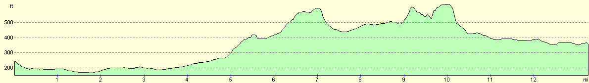
For more information on profiles, ascents and descents, see this page
Transport
There are bus services running from Luton to Hitchin that depart from Luton bus station at regular intervals. Currently this service is the 100/101, running from Luton to Hitchin to Stevenage.
Disclaimer
Please note that I take no responsibility for anything that may happen when following these directions. If you intend to follow this route, then please use the relevant maps and check the route out before you go out. As always when walking, use common sense and you should be fine.
If you find any information on any of these routes that is inaccurate, or you wish to add anything, then please email me.
All images on this site are © of the author. Any reproduction, retransmissions, or republication of all or part of any document found on this site is expressly prohibited, unless the author has explicitly granted its prior written consent to so reproduce, retransmit, or republish the material. All other rights reserved.
Although this site includes links providing convenient direct access to other Internet sites, I do not endorse, approve, certify or make warranties or representations as to the accuracy of the information on these sites.
And finally, enjoy your walking!
Nearby walks
| # | Title | Walk length (miles) |
|---|---|---|
| 121 | Royston to Hitchin | 17.3 |
| 122 | Biggleswade to Hitchin | 11.6 |
| 129 | Dunstable to Tring | 14.1 |
|
|

|