Walk #122: Biggleswade to Hitchin
 |
 |
|
General Data
| Date Walked | 08/10/2000 |
| County | Bedfordshire, Hertfordshire |
| Start Location | Biggleswade |
| End Location | Hitchin |
| Start time | 09.45 |
| End time | 14.37 |
| Distance | 11.6 miles |
| Description | This walk was a mixture of road and path walking southwards from Biggleswade. It was not a very inspiring walk, but was nonetheless enjoyable. |
| Pack | Today I carried a minimal pack, with no tent or spare clothes. |
| Condition | I am more tired than I was after yesterday's longer walk, and I found the last few miles a bit more of a struggle, but nothing too major. I have a hotspot on the side of my left-hand heel that may develop into a blister that was caused by some mud getting into my boot whilst crossing a ploughed field. My shoulders also ache slightly, and I had a tiny amount of trouble with the underside of my left knee, a legacy of may trip to Scotland a fortnight ago. |
| Weather | After a very wet day yesterday I was praying for dry weather, and fortunately my prayers were answered and there was no rain. There was a mixture of sun and cloud periods and not too much wind, but today was definitely an autumnal day, and the temperature did not get too high. All in all a good walking day. |
| OS map | Landranger number 153 (Bedford & Huntingdon, St Neots & Biggleswade) and Landranger number 166 (Luton & Hertford, Hitchin & St Albans) |
Map of the walk
Maps courtesy of Google Maps. Route for indicative purposes only, and may have been plotted after the walk. Please let me have comments on what you think of this new format. For a detailed table of timings for this walk, please see the table file.
Notes
Today was a fairly boring day, and the only reason for doing it was to link up the walks I had completed south from Huntingdon with the one that I finished yesterday in Huntingdon. I have now completed a circular walk from Waterbeach - Huntingdon - Hitchin - Royston - Great Chesterford and back to Waterbeach (but not all legs were done in the same direction), which is a nice feeling, and gives my 'silly walks' generator more alternative routes to get it's teeth into. It also gives me the ability to extend the walk along he Icknield Way from Hitchin southwest past Luton and on towards Tring and the start of the Ridgeway. I was not expecting to be able to do any walking this weekend, but the visitor I was due to have cancelled, which gave me a free weekend which I could use to do these two walks.
For some reason I found today harder going than yesterday, despite the fact that the weather was far better (it was not bucketing it down) and the walk was shorter. There was more road walking involved, which is always harder on my feet than path walking, especially when I am wearing my X-Adventure 7 boots. Unfortunately my boots were still damp (and the left one wet) from yesterday, so my socks got damp as soon as they went into the boots, which did not make for ideal walking. The main crux of the problem was mental, as soon after I started I lost most of my impetus for doing the walk. This situation only recovered when I was in the pub in Ickleford, when I started to feel better. Of course, this had nothing to do with he pint that I had. ;-)
I have now completed four walks in the last two weekends, which makes a nice total of over 50 miles. I will not be able to do nay walks for the next two weekends, as I have a visitor next weekend and the weekend after that I am going to visit a friend and my family.
The going was very rough on some of the path sections due to ploughing and the heavy rain that there has been over the last few days. All I needed to do was take a few steps in a field and I would end up with large clods of mud glued to the soles of my boots, weighing them down. Of course this also made the walking harder, but at least my trousers did not get dirty as they did with the combination of rain and mud yesterday.
When I was at Oldfield Farm south of Henlow I passed just to the east of Henlow Airfield, an MOD airfield, and quite a few airplanes could be seen overhead at various times. At one stage four planes flew overhead in classic aerobatics formation, with three planes in a triangle and another trailing slightly further behind. According to the farmer who was in the field the pilots would be undergoing aerobatic training. Another curiosity was that beside the track heading south towards Oldfield Farm I passed an MOD sewerage farm which was part of the Henlow Airfield site. I am surprised by the fact that the MOD have their own water treatment facilities and do not use the public ones, bit there you go - the military always have to do things independently!
Directions
From Biggleswade railway station turn right towards the town centre and past the police station. When you reach the square turn right and head over the railway bridge. Just over the bridge turn right by the Red Lion Pub and head along London Road. Continue on and turn right down Elm Road when it is reached, and then left along Mead End. Just past Oak Crescent a footpath leads off to the right. At the end turn left down Holme Court Avenue. Continue on and then turn right down another footpath which leads to another road. To the left is a grassy area skirting the A1. Follow this grassy area southwards until you reach a track that leads through a bridge under the A1.
Continue south on this track, being careful not to be sidetracked by many of the other tracks in the area. Eventually the track ends and the bridleway continues on to the south and ends at a T-junction with another track. Turn right down this track, cross the railway and follow the track as it becomes East Road and ends at the A6001 in Langford.
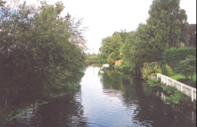
Turn left and head south along the A6001 through Langford, passing some shops and the church. A couple of hundred yards past Station Road a footpath leads off to the right just before a sharp left-hand bend in the road. Take this footpath and cross a bridge over the River Hiz. At the other side of the bridge take a footpath to the left that heads across some fields to the south-southwest.
This footpath ends at the A6001. Turn to the right and just past the garden centre a footpath heads across fields to the left. Unfortunately today this field was ploughed and fairly hard going, so I opted to walk along the A6001 which is a bit longer but does have a pavement the whole way. Walk west along the A6001 and then south after a bend until Henlow is reached. Walk southwards through Henlow on the A6001 until a roundabout is reached. Cross over this roundabout and another is almost immediately reached. Cross over this one and head south along the A6001 towards Hitchin. After nearly a kilometre a farm called The Cedars is reached on the left. Just past this farm a track, Middlefield Lane, heads away in a more-or-less southerly direction.
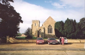
Follow the lane past south past an MOD sewage farm and when the track ends at a T-junction with another track take a path heading straight on beside a drainage ditch to Oldfield Farm. Skirt to the left of the farm buildings and continue south to a bridge over a stream (note that when I did this walk many of the bridges over the streams on this section of the walk were very overgrown). Cross the stream and head across to another track. Cross the track and head southeast across a couple of small drainage ditches to New Ramerwick Farm. Follow the footpath south from the farm for just under a kilometre until a T-junction with a bridleway is reached. Turn left down the bridleway until it becomes a track in Lower Green. This track soon bends around to the south and becomes paved before meeting Arlesley road in Ickleford. Turn right down this road and head south to Ickleford Church.
Just past the church take the left-hand fork in the road and continue south towards Hitchin. After just over a kilometre take the first major road to the left, called Strathmore Avenue, opposite a school. This road leads to a roundabout which you can cross over to join Water Lane. Water Lane soon ends and you can turn right down Grove Road to meet a main road. Turn left down this main road and after a couple of roundabouts Walsworth Road leads uphill to the right just before the railway line is reached. The Station Approach is almost immediately to the left up Walsworth Road.
Distances
| From | To | Distance (m) | Ascent (ft) | Descent (ft) |
|---|---|---|---|---|
| Biggleswade | Henlow Church | 5.2 | 89 | 66 |
| Henlow Church | Ickleford | 4.6 | 102 | 66 |
| Ickleford | Hitchin Station | 1.8 | 98 | 20 |
This makes a total distance of 11.6 miles, with 289 feet of ascent and 152 feet of descent.
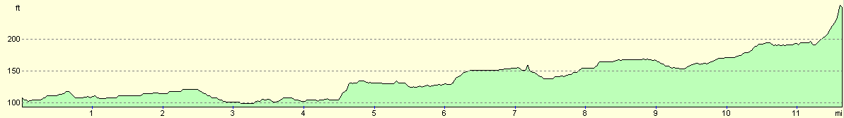
For more information on profiles, ascents and descents, see this page
Transport
There are regular train services between Hitchin and Biggleswade, with an intermediate station at Arlesley.
Disclaimer
Please note that I take no responsibility for anything that may happen when following these directions. If you intend to follow this route, then please use the relevant maps and check the route out before you go out. As always when walking, use common sense and you should be fine.
If you find any information on any of these routes that is inaccurate, or you wish to add anything, then please email me.
All images on this site are © of the author. Any reproduction, retransmissions, or republication of all or part of any document found on this site is expressly prohibited, unless the author has explicitly granted its prior written consent to so reproduce, retransmit, or republish the material. All other rights reserved.
Although this site includes links providing convenient direct access to other Internet sites, I do not endorse, approve, certify or make warranties or representations as to the accuracy of the information on these sites.
And finally, enjoy your walking!
Nearby walks
| # | Title | Walk length (miles) |
|---|---|---|
| 120 | St Neots to Biggleswade | 13.0 |
| 121 | Royston to Hitchin | 17.3 |
| 127 | Hitchin to Luton | 13.2 |
|
|

|